close
-
Layers w
- Weather Layers
- Pro
- Pro
- Pro
- Pro
- Pro
- Pro
- More Layers
- Pro
- Pro
- Pro
- Pro
-
Upgrade to

3D
Trail Conditions
- Unknown
- Snow Groomed
- Snow Packed
- Snow Covered
- Snow Cover Partial
- Freeze/thaw Cycle
- Icy
- Prevalent Mud
- Wet
- Variable
- Ideal
- Dry
- Very Dry
Trail Flow (Ridden Direction)
Trailforks scans users ridelogs to determine the most popular direction each trail is ridden. A good flowing trail network will have most trails flowing in a single direction according to their intension.
The colour categories are based on what percentage of riders are riding a trail in its intended direction.
The colour categories are based on what percentage of riders are riding a trail in its intended direction.
- > 96%
- > 90%
- > 80%
- > 70%
- > 50%
- < 50%
- bi-directional trail
- no data
Trail Last Ridden
Trailforks scans ridelogs to determine the last time a trail was ridden.
- < 2 days
- < 1 week
- < 2 weeks
- < 1 month
- < 6 months
- > 6 months
Trail Ridden Direction
The intended direction a trail should be ridden.
- Downhill Only
- Downhill Primary
- Both Directions
- Uphill Primary
- Uphill Only
- One Direction
Contribute Details
Colors indicate trail is missing specified detail.
- Description
- Photos
- Description & Photos
- Videos
Trail Popularity ?
Trailforks scans ridelogs to determine which trails are ridden the most in the last 9 months.
Trails are compared with nearby trails in the same city region with a possible 25 colour shades.
Think of this as a heatmap, more rides = more kinetic energy = warmer colors.
- most popular
- popular
- less popular
- not popular
ATV/ORV/OHV Filter
Max Vehicle Width
inches
US Cell Coverage
Legend

Radar Time
Activity Recordings
Trailforks uses anonymized public activity data.
?
Activity Recordings
Trailforks uses anonymized public activity data.
?
Personal Heatmap
▶
Activity Types
all
/
none
▶
Options
2
Date range
month
–
Winter Trails
Warning
A routing network for winter maps does not exist. Selecting trails using the winter trails layer has been disabled.
Missing Trails
Most Popular
Least Popular
Trails are colored based on popularity. The more popular a trail is, the more red. Less popular trails trend towards green.
Jump Magnitude Heatmap
Heatmap of where riders jump on trails. Zoom in to see individual jumps, click circles to view jump details.
BC Backroad Status
![map legend]()
Service Road Atlas is a free to use, community-driven service for viewing and creating reports on the numerous back-country service roads around B.C. and Alberta.

Slope Aspect
Direction the slope faces
Trails Deemphasized
Trails are shown in grey.
Only show trails with no bike usage.
Suggested Layers
Based on selected activity type
Save the current map location and zoom level as your default home location whenever this page is loaded.
Save
No description for Aurel has been added yet!
Login or register to submit one.
This region uses the Uk/Euro style trail grading system.
Activities Click to view
- Mountain Bike
6 trails
- Hike
6 trails
- Trail Running
6 trails
Region Details
- 3
- 1
- 2
Region Status
Open as of May 10, 2024Stats
- Avg Trail Rating
- Trails (view details)
- 6
- Trails Mountain Bike
- 6
- Trails E-Bike
- 1
- Trails Hike
- 6
- Trails Trail Running
- 6
- Total Distance
- 8 miles
- Total Descent Distance
- 4 miles
- Total Descent
- 3,209 ft
- Total Vertical
- 2,091 ft
- Highest Trailhead
- 4,430 ft
- Reports
- 1
- Ridden Counter
- 7
Popular Aurel Mountain Biking Trails
• 5 ★ 5.0 • 2 miles • 0 ft • 1 •
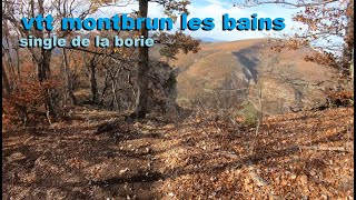
Monter par la piste depuis montbrun vers barret de lioure puis direction col de l homme mort , la un single balcon monte au depart du single et evite le sommet col pointu et col nu ..de la debut de la descente pres du ravin a votre...
• 5 ★ 5.0 • 1 mile • 50 ft • 1 •
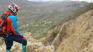
Descente assez facile pour rejoindre la chapelle de la donne ..attention falaise et rocher au point de vue ,voir video jointe ..acces depuis barret de lioure par une piste voir ign et retour par une autre piste au bas de barret ..michmich
• 5 ★ 0.0 • 3 miles • 9 ft • 1 • • hike
Less popular red difficulty singletrack. This hike primary trail can be used downhill primary. Trail visibility is always easy to follow.
Aurel Mountain Bike Routes
33 miles • 3,299 ft • 0 • Point to Point •
The fourth stage of Vaucluse Great Crossing made for mtb by the Vaucluse Tourism Office From Aurel, the...
Videos of Aurel Mountain Bike
7:57 |
95 |
Mar 9, 2023 , Aurel
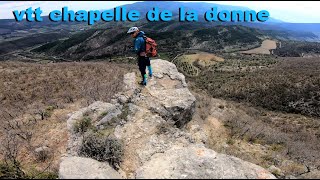
trail: Chapelle De La Donne
8:06 |
95 |
Mar 9, 2023 , Aurel
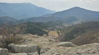
trail: Liaison Chapelle De La Donne
8:06 |
56 |
Feb 9, 2023 , Aurel

7:57 |
59 |
Feb 9, 2023 , Aurel
7:57 |
128 |
Feb 9, 2023 , Aurel
Recent Trail Reports
| status | trail | date | condition | info | user |
|---|---|---|---|---|---|
| Liaison Chapelle De La Donne | May 9, 2024 @ 8:17am May 9, 2024 | Dry | Tom39 |
Activity Feed
| username | action | type | title | date |
|---|---|---|---|---|
| 0um6Q3 | wishlist | trail | activity #96159755 | Jun 3, 2026 @ 9:04am Jun 3, 2026 |
| FrC74 | wishlist | trail | activity #84623144 | Nov 23, 2025 @ 1:09pm Nov 23, 2025 |
| provencemb | add | trail | activity #60630144 | Oct 17, 2024 @ 10:06pm Oct 17, 2024 |
| Tom39 | add | report | activity #52364187 | May 10, 2024 @ 5:36am May 10, 2024 |
| michmich6639 | add | video | activity #37998676 and 1 more | Mar 9, 2023 @ 10:42am Mar 9, 2023 |
Recent Comments
| username | type | title | comment | date |
|---|---|---|---|---|
| trail | Voir la video jointe pour comprendre la fin | Feb 9, 2023 @ 10:44am Feb 9, 2023 | ||
| trail | La fin n est pas sur cet trace mais il faut... | Feb 9, 2023 @ 10:43am Feb 9, 2023 |
Activity Type Stats
| activitytype | trails | distance | descent | descent distance | total vertical | rating | global rank | state rank | photos | reports | routes | ridelogs |
|---|---|---|---|---|---|---|---|---|---|---|---|---|
| Mountain Bike | 6 | 8 miles | 3,209 ft | 4 miles | 2,090 ft | #6,478 | #275 | 1 | 1 | 354 | ||
| E-Bike | 1 | 1 | 2 | |||||||||
| Hike | 6 | 8 miles | 3,209 ft | 4 miles | 2,090 ft | #10,606 | #544 | 1 | 16 | |||
| Trail Running | 6 | 8 miles | 3,209 ft | 4 miles | 2,090 ft | #10,239 | #524 | 1 |
Frequently Asked Questions About Aurel
▼
What are the highest rated mountain biking trails in Aurel?
The highest rated mountain biking trails in Aurel are:
- Chapelle De La Donne (4.1/5)
- Col Nu Bories Montbrun Les Bains (4.1/5)
- Clos Arthaud (0/5)
▼
What is the best time of the year to ride in Aurel?
Based on ride log data, the most popular months to ride in Aurel are:
- July (5 activities)
- October (4 activities)
- March (3 activities)
▼
Where can I park to ride in Aurel?
Check the Aurel trail map for trailhead and parking information. Community members regularly update access and parking details for trails in the area.
▼
What is the longest trail in Aurel?
The longest trail in Aurel is Clos Arthaud at 2.8 miles. View all trails sorted by distance.
- By tomzaniroli
 TRAILFORKS TFFRANCE & contributors
 - Admins: tomzaniroli
- #23338 - 683 views
- aurel activity log | embed map of Aurel mountain bike trails |
Downloading of trail gps tracks in kml & gpx formats is enabled for Aurel.
You must login to download files.