close
-
Layers w
- Weather Layers
- Pro
- Pro
- Pro
- Pro
- Pro
- Pro
- More Layers
- Pro
- Pro
- Pro
- Pro
-
Upgrade to

3D
Trail Conditions
- Unknown
- Snow Groomed
- Snow Packed
- Snow Covered
- Snow Cover Partial
- Freeze/thaw Cycle
- Icy
- Prevalent Mud
- Wet
- Variable
- Ideal
- Dry
- Very Dry
Trail Flow (Ridden Direction)
Trailforks scans users ridelogs to determine the most popular direction each trail is ridden. A good flowing trail network will have most trails flowing in a single direction according to their intension.
The colour categories are based on what percentage of riders are riding a trail in its intended direction.
The colour categories are based on what percentage of riders are riding a trail in its intended direction.
- > 96%
- > 90%
- > 80%
- > 70%
- > 50%
- < 50%
- bi-directional trail
- no data
Trail Last Ridden
Trailforks scans ridelogs to determine the last time a trail was ridden.
- < 2 days
- < 1 week
- < 2 weeks
- < 1 month
- < 6 months
- > 6 months
Trail Ridden Direction
The intended direction a trail should be ridden.
- Downhill Only
- Downhill Primary
- Both Directions
- Uphill Primary
- Uphill Only
- One Direction
Contribute Details
Colors indicate trail is missing specified detail.
- Description
- Photos
- Description & Photos
- Videos
Trail Popularity ?
Trailforks scans ridelogs to determine which trails are ridden the most in the last 9 months.
Trails are compared with nearby trails in the same city region with a possible 25 colour shades.
Think of this as a heatmap, more rides = more kinetic energy = warmer colors.
- most popular
- popular
- less popular
- not popular
ATV/ORV/OHV Filter
Max Vehicle Width
inches
US Cell Coverage
Legend

Radar Time
Activity Recordings
Trailforks uses anonymized public activity data.
?
Activity Recordings
Trailforks uses anonymized public activity data.
?
Personal Heatmap
▶
Activity Types
all
/
none
▶
Options
2
Date range
month
–
Winter Trails
Warning
A routing network for winter maps does not exist. Selecting trails using the winter trails layer has been disabled.
Missing Trails
Most Popular
Least Popular
Trails are colored based on popularity. The more popular a trail is, the more red. Less popular trails trend towards green.
Jump Magnitude Heatmap
Heatmap of where riders jump on trails. Zoom in to see individual jumps, click circles to view jump details.
BC Backroad Status
![map legend]()
Service Road Atlas is a free to use, community-driven service for viewing and creating reports on the numerous back-country service roads around B.C. and Alberta.

Slope Aspect
Direction the slope faces
Trails Deemphasized
Trails are shown in grey.
Only show trails with no bike usage.
Suggested Layers
Based on selected activity type
Save the current map location and zoom level as your default home location whenever this page is loaded.
Save
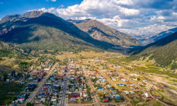
No description for Bigfork has been added yet!
Login or register to submit one.
Activities Click to view
- Mountain Bike
94 trails
- E-Bike
3 trails
- Gravel Bike
19 trails
- Adaptive Bike
23 trails
- Winter Fat Bike
36 trails
- Horse
4 trails
- Hike
101 trails
- Trail Running
99 trails
- Snowshoe
10 trails
- Backcountry Ski
3 trails
- Nordic Ski
13 trails
Region Details
- 12
- 1
- 11
- 36
- 31
- 3
Region Status
Caution as of Jun 2, 2026Local Trail Association
Stats
- Avg Trail Rating
- Trails (view details)
- 121
- Trails Mountain Bike
- 94
- Trails E-Bike
- 3
- Trails Gravel Bike
- 19
- Trails Adaptive Bike
- 23
- Trails Winter Fat Bike
- 36
- Trails Horse
- 4
- Trails Hike
- 101
- Trails Trail Running
- 99
- Trails Dirtbike/Moto
- 1
- Trails ATV/ORV/OHV
- 2
- Trails Snowshoe
- 10
- Trails Backcountry Ski
- 3
- Trails Nordic Ski
- 13
- Total Distance
- 178 miles
- Total Descent
- 37,425 ft
- Total Vertical
- 4,621 ft
- Highest Trailhead
- 7,518 ft
- Reports
- 805
- Photos
- 445
- Ridden Counter
- 4,974
Articles
The Top 9 Small Adventure Towns in the U.S.
Apr 16, 2025 from outsideonline.com
These tiny hamlets, with less than 6,000 locals, provide the perfect blend of quaint vibes and outdoor fun
Sub Regions
-
Crane Mountain Trails
- 1
- 19
- 12
- 2
-
Harrell Forest Community Trails
- 4
-
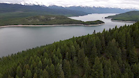
Jewel Basin
- 3
- 4
- 14
- 2
Popular Bigfork Mountain Biking Trails
• 90 ★ 4.8 • 3,846 ft • 90 ft • 140 •
This route is the easy way to access the top of the trail. There is a more popular route to the top. This trail has several drops and long rock-rolls to make it one of the most popular trails in the area.
• 70 ★ 4.2 • 7 miles • 315 ft • 137 •
This trail was rated the 5th best mountain bike trail in the state and you can shuttle it. Just drive up Crane Mountain road 9 miles to the top trail-head. From the top you start with an easy climb for 1.5 miles then it's time to go...
• 95 ★ 4.0 • 1,905 ft • 26 ft • 114 •
Trail is off of the trail. Entrance is slightly hidden currently, but trail opens up. Nice drops, views, and steep descents characterize this trail. Built as a practice fire line originally by the Flathead Hotshot fire crew.
• 75 ★ 0.0 • 3 miles • 88 ft • 110 •
Popular white difficulty paved path. This multi-use trail can be used both directions and has a easy overall physical rating with a 88 ft green climb. On average it takes 12 minutes to complete this trail.
• 90 ★ 4.2 • 3 miles • 478 ft • 107 •
From Hwy 35 it's going to be a push for most of us up to one of the best views of Flathead Lake. That's a great out and back that way. From The Crane Road the trail starts out as a steep climb but only for a distance then the trail...
• 80 ★ 3.7 • 2,107 ft • 153 ft • 102 •
Just a short trail to one of the best views of the area.
• 90 ★ 3.5 • 1,865 ft • 3 ft • 85 •
Popular blue difficulty singletrack. This mountain bike primary trail can be used downhill primary and has a moderate overall physical rating. On average it takes 5 minutes to complete this trail.
Bigfork Mountain Bike Routes
12 miles • 1,935 ft • 4 • Shuttled •
From the top, to the lake, back to the bottom.
15 miles • 4,419 ft • 4 •
The recommended loop I am creating is based on a local Whitefish MTBer. Apparently, this direction gives...
• 7 miles • 344 ft • 1 •
• 4 miles • 841 ft • 3 •
• 1 mile • 113 ft • 2 •
• 3 miles • 451 ft • 2 •
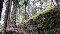
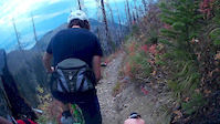
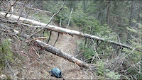
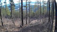
Videos of Bigfork Mountain Bike

trail: Crevice
0:12 |
|
May 16, 2025

trail: Crevice
0:12 |
31 |
May 16, 2025
trail: Crevice
0:12 |
|
May 16, 2025
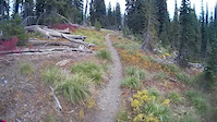
trail: Jimmy Ridge
0:16 |
116 |
May 26, 2020
trail: Jimmy Ridge
0:01 |
386 |
Sep 28, 2015
trail: Jimmy Ridge
3:01 |
476 |
Sep 28, 2015
trail: Phillips Trail
3:15 |
105 |
Apr 1, 2015
trail: Crator Notch
2:38 |
115 |
Mar 9, 2015
Recent Trail Reports
Activity Feed
| username | action | type | title | date |
|---|---|---|---|---|
| FAMB | add | report | activity #96113594 | Jun 2, 2026 @ 3:33pm Jun 2, 2026 |
| Oldschool55 | comment | trail | activity #95887867 | May 30, 2026 @ 2:32pm May 30, 2026 |
| Oldschool55 | vote | trail | activity #95887709 and 2 more | May 30, 2026 @ 2:30pm May 30, 2026 |
| Oldschool55 | ridden | trail | activity #95887700 and 2 more | May 30, 2026 @ 2:30pm May 30, 2026 |
| kntr | add | report | activity #95768522 | May 29, 2026 @ 5:02am May 29, 2026 |
Recent Comments
| username | type | title | comment | date |
|---|---|---|---|---|
| trail | Great rock features with solid pucker factors.... | May 30, 2026 @ 2:32pm May 30, 2026 | ||
| trail | New trail in crane mtn area, after logging | Oct 28, 2025 @ 2:29pm Oct 28, 2025 | ||
| trail | This is a great blue technical trail! Keep... | Aug 27, 2025 @ 4:11pm Aug 27, 2025 | ||
| trail | I agree with the look before you leap. ... | Aug 27, 2025 @ 4:09pm Aug 27, 2025 | ||
| trail | I rode this on 7/9/25 from the road up top to... | Jul 10, 2025 @ 2:55pm Jul 10, 2025 |
Local Badges
-

10 Blue Trails30 awarded -

10 Black Trails6 awarded -

Epic Ride Climb 2k46 awarded -

Climbing 10k Badge8 awarded -

Climbing 100k Badge1 awarded -

Epic Ride Descent 2k41 awarded
Local Trail Supporters
- The Trust For Public Land
- Montana Land Reliance
- Flathead Land Trust
Activity Type Stats
| activitytype | trails | distance | descent | descent distance | total vertical | rating | global rank | state rank | photos | reports | routes | ridelogs |
|---|---|---|---|---|---|---|---|---|---|---|---|---|
| Mountain Bike | 94 | 149 miles | 31,785 ft | 57 miles | 4,249 ft | #1,319 | #501 | 410 | 793 | 2 | 3,053 | |
| E-Bike | 3 | 12 miles | 2,336 ft | 9 miles | 3,356 ft | #5,967 | #1,824 | 3 | 479 | 85 | ||
| Gravel Bike | 19 | 40 miles | 5,141 ft | 12 miles | 3,383 ft | #316 | #945 | 1 | 79 | 40 | ||
| Adaptive Bike | 23 | 52 miles | 5,233 ft | 18 miles | 3,327 ft | #252 | #1,607 | 70 | 1 | |||
| Winter Fat Bike | 36 | 52 miles | 9,304 ft | 18 miles | 4,045 ft | #175 | #973 | 268 | ||||
| Horse | 4 | 17 miles | 4,524 ft | 12 miles | 3,675 ft | #1,899 | #1,068 | 265 | ||||
| Hike | 101 | 167 miles | 34,318 ft | 64 miles | 4,623 ft | #914 | #415 | 25 | 718 | 778 | ||
| Trail Running | 99 | 164 miles | 33,901 ft | 62 miles | 4,623 ft | #1,052 | #390 | 718 | 313 | |||
| Dirtbike/Moto | 1 | 9 miles | 2,260 ft | 8 miles | 2,211 ft | 259 | 11 | |||||
| ATV/ORV/OHV | 2 | 10 miles | 2,431 ft | 9 miles | 2,211 ft | 260 | ||||||
| Snowshoe | 10 | 9 miles | 1,483 ft | 3 miles | 4,514 ft | #963 | #470 | 12 | 33 | |||
| Backcountry Ski | 3 | 2 miles | 1,040 ft | 1 mile | 1,296 ft | #565 | #173 | 8 | 151 | |||
| Nordic Ski | 13 | 7 miles | 571 ft | 2 miles | 295 ft | #145 | #38 | 6 | 7 | 157 |
Frequently Asked Questions About Bigfork
▼
What are the best places to ride in Bigfork?
Bigfork has 5 areas to explore for mountain biking. The top rated areas are:
▼
What are the highest rated mountain biking trails in Bigfork?
The highest rated mountain biking trails in Bigfork are:
- Original Sin (4.6/5)
- Hammer Bear Ridge (4.2/5)
- Birch Loop (4.1/5)
- River View Trail (4.1/5)
- Summit Loop (4.1/5)
▼
What is the best time of the year to ride in Bigfork?
Based on ride log data, the most popular months to ride in Bigfork are:
- July (63 activities)
- May (41 activities)
- August (37 activities)
▼
Where can I park to ride in Bigfork?
There are 18 parking locations listed in Bigfork. The most popular parking spots are:
- Parking
- Lower pick-up & parking area.
- Parking
- Top drop-off and parking area.
- Main Trailhead Parking Area.
Activities
Trails
- By MONTANABIKERMAN
 FTF & contributors
 - Admins: FAMB, JeffVonKiper
- #6080 - 14,144 views
- bigfork activity log | embed map of Bigfork mountain bike trails | bigfork mountain biking points of interest
Downloading of trail gps tracks in kml & gpx formats is enabled for Bigfork.
You must login to download files.