close
-
Layers w
- Weather Layers
- Pro
- Pro
- Pro
- Pro
- Pro
- Pro
- More Layers
- Pro
- Pro
- Pro
- Pro
-
Upgrade to

3D
Trail Conditions
- Unknown
- Snow Groomed
- Snow Packed
- Snow Covered
- Snow Cover Partial
- Freeze/thaw Cycle
- Icy
- Prevalent Mud
- Wet
- Variable
- Ideal
- Dry
- Very Dry
Trail Flow (Ridden Direction)
Trailforks scans users ridelogs to determine the most popular direction each trail is ridden. A good flowing trail network will have most trails flowing in a single direction according to their intension.
The colour categories are based on what percentage of riders are riding a trail in its intended direction.
The colour categories are based on what percentage of riders are riding a trail in its intended direction.
- > 96%
- > 90%
- > 80%
- > 70%
- > 50%
- < 50%
- bi-directional trail
- no data
Trail Last Ridden
Trailforks scans ridelogs to determine the last time a trail was ridden.
- < 2 days
- < 1 week
- < 2 weeks
- < 1 month
- < 6 months
- > 6 months
Trail Ridden Direction
The intended direction a trail should be ridden.
- Downhill Only
- Downhill Primary
- Both Directions
- Uphill Primary
- Uphill Only
- One Direction
Contribute Details
Colors indicate trail is missing specified detail.
- Description
- Photos
- Description & Photos
- Videos
Trail Popularity ?
Trailforks scans ridelogs to determine which trails are ridden the most in the last 9 months.
Trails are compared with nearby trails in the same city region with a possible 25 colour shades.
Think of this as a heatmap, more rides = more kinetic energy = warmer colors.
- most popular
- popular
- less popular
- not popular
ATV/ORV/OHV Filter
Max Vehicle Width
inches
US Cell Coverage
Legend

Radar Time
Activity Recordings
Trailforks uses anonymized public activity data.
?
Activity Recordings
Trailforks uses anonymized public activity data.
?
Personal Heatmap
▶
Activity Types
all
/
none
▶
Options
2
Date range
month
–
Winter Trails
Warning
A routing network for winter maps does not exist. Selecting trails using the winter trails layer has been disabled.
Missing Trails
Most Popular
Least Popular
Trails are colored based on popularity. The more popular a trail is, the more red. Less popular trails trend towards green.
Jump Magnitude Heatmap
Heatmap of where riders jump on trails. Zoom in to see individual jumps, click circles to view jump details.
BC Backroad Status
![map legend]()
Service Road Atlas is a free to use, community-driven service for viewing and creating reports on the numerous back-country service roads around B.C. and Alberta.

Slope Aspect
Direction the slope faces
Trails Deemphasized
Trails are shown in grey.
Only show trails with no bike usage.
Suggested Layers
Based on selected activity type
Save the current map location and zoom level as your default home location whenever this page is loaded.
SaveBright is a town in northeastern Victoria, Australia, 319 metres above sea level at the southeastern end of the Ovens Valley. At the 2021 census, Bright had a population of 2,620. It is located in the Alpine Shire local government area.
The town serves as an ideal launch pad for a range of outdoor activities, from a substantial mountain bike scene to access to the various ski resorts in the region.
The town serves as an ideal launch pad for a range of outdoor activities, from a substantial mountain bike scene to access to the various ski resorts in the region.
Activities Click to view
- Mountain Bike
118 trails
- E-Bike
120 trails
- Gravel Bike
8 trails
- Adaptive Bike
6 trails
- Winter Fat Bike
2 trails
- Hike
80 trails
- Trail Running
84 trails
- Dirtbike/Moto
0 trails
Region Details
- 1
- 1
- 8
- 14
- 2
- 1
Region Status
Caution as of 1 dayStats
- Avg Trail Rating
- Trails (view details)
- 27
- Trails Mountain Bike
- 118
- Trails E-Bike
- 120
- Trails Gravel Bike
- 8
- Trails Adaptive Bike
- 6
- Trails Winter Fat Bike
- 2
- Trails Hike
- 80
- Trails Trail Running
- 84
- Reports
- 331
- Photos
- 93
- Ridden Counter
- 11,005
Articles
Kona Factory Team Australia - National Series Round 3 by Lube
Apr 6, 2026 from pinkbike.com
Check out Australia's fastest racers going flat out at. We can't wait to see Hill, Kovarik, and Fearon race more this season.

Destination Showcase: High Country Victoria, Australia
Jan 29, 2020 from pinkbike.com
Discover the best trails, places to eat and drink and a few local secrets in Bright, Beechworth, and Falls Creek.
Sub Regions
-
Mystic Bike Park
- 14
- 56
- 24
- 7
Popular Bright Mountain Biking Trails
• 100 ★ 4.7 • 1 mile • 12 ft • 2,715 •
is one of Mystic's crowd favourites. This machine built flow trail is full of Berms ✔ Speed ✔ Jumps ✔ & Flowy Goodness✔ It's one hell of a ride all the way back to Morses Creek and the car park.
• 100 ★ 4.2 • 518 ft • 0 ft • 2,698 •
Popular blue difficulty singletrack. This mountain bike primary trail can be used one direction and has a moderate overall physical rating with a 0 ft green climb. It features berm. Trail visibility is always easy to follow. On average it takes minutes to complete this trail.
• 90 ★ 4.5 • 2,795 ft • 3 ft • 2,645 •
Mystic's trail is a 3km flow trail filled with big berms and jumps of all sizes. Most of the jumps can be rolled over or have optional A & B lines. It is highly recommended to do a sighting run first, to get to know the flow.
• 90 ★ 4.3 • 1,125 ft • 0 ft • 2,531 •
Great little track to blast down! Roots, little jumps and mainly flat corners. It'll leave you smiling at the end.
• 90 ★ 3.8 • 509 ft • 12 ft • 2,444 •
Small Linking trail around the Dam --- This trail only links into Shred Kelly now down the ttps://www.trailforks.com/trails/link-214739/]link[/L]
• 80 ★ 4.0 • 2,287 ft • 5 ft • 1,963 •
Flowing hand built track. Nothing too technical.
Bright Mountain Bike Routes
Loop 4 - Hot Wheels (White) Featured
★ 4.5 • 1 mile • 45 ft • 1 • Loop •
is a fun 2km loop with many berms, twists and turns. It is ideal for beginners looking for a wide...
Loop 5 - Pine Planters (Purple) Featured
★ 4.0 • 4 miles • 651 ft • 9 • Loop •
A long and varied loop ride in pine and eucalypt forest, with rolling tracks in old mine tailings along...
★ 3.0 • 6 miles • 1,105 ft • 8 • Loop •
A popular intermediate loop ride that takes in some of Mystic's most fun flow trails: Trail and . Follow...
★ 1.0 • 4 miles • 404 ft • 7 • Loop •
This is a predominantly easy loop that introduces sections of intermediate trail on cross country...
★ 2.0 • 8 miles • 1,480 ft • 13 • Loop •
24 Carat is a long and varied loop that takes in a bit of everything Mystic has to offer. The descent has...
★ 2.7 • 5 miles • 847 ft • 14 • Loop •
Loop 3 - Eureka - is a blue rated loop trail with a steep black pinch half way. It requires a moderate...
Photos of Bright Mountain Bike
Videos of Bright Mountain Bike
featured
![Gravity Uplift & Check-in for Mystic Bike...]()

0:04 |
167 |
Nov 17, 2024
featured
![Flowmingo | Mystic Bike Park | GoPRO Trail Of...]()
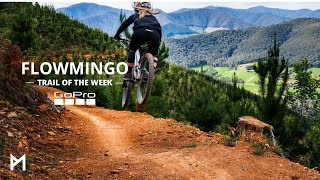
trail: Lower Flowmingo
4:51 |
539 |
Nov 7, 2024 , Bright
featured
![Mystic Mountain Bike Park]()
3:01 |
306 |
May 22, 2024
featured
![Shred Kellys last stand]()

trail: Shred Kelly's Last Stand
4:21 |
1538 |
Dec 2, 2018 , Bright
trail: Shred Kelly's Last Stand
0:12 |
38 |
Oct 11, 2025
trail: Brexit
0:05 |
97 |
Oct 9, 2023

trail: Lower Hero
2:09 |
118 |
Aug 31, 2023
trail: Lockdown
0:10 |
64 |
Dec 4, 2022
Recent Trail Reports
| status | trail | date | condition | info | user |
|---|---|---|---|---|---|
| Slider | Jun 8, 2026 @ 10:43am (Australia/Melbourne) 1 day | Ideal | streddaz CCMBC | ||
| Jayne Link | Jun 8, 2026 @ 10:43am (Australia/Melbourne) 1 day | Ideal | streddaz CCMBC | ||
| Hokey Pokey Extension | Jun 8, 2026 @ 10:43am (Australia/Melbourne) 1 day | Ideal | streddaz CCMBC | ||
| Tombstone | Jun 8, 2026 @ 10:43am (Australia/Melbourne) 1 day | Ideal | streddaz CCMBC | ||
| Jumping Jacks | Jun 8, 2026 @ 10:43am (Australia/Melbourne) 1 day | Ideal | streddaz CCMBC | ||
| Upper Flowmingo | Jun 8, 2026 @ 10:43am (Australia/Melbourne) 1 day | Ideal | streddaz CCMBC | ||
| Stairway to Shreddin’ | Jun 8, 2026 @ 10:43am (Australia/Melbourne) 1 day | Ideal | streddaz CCMBC | ||
| Marcus' Mayhem | Jun 8, 2026 @ 11:26am (Australia/Melbourne) 1 day | Ideal | Dirtandwater | ||
| 24 Sycamore | May 31, 2026 @ 10:18pm (Australia/Melbourne) May 31, 2026 | Ideal | ashg08 | ||
| Huggins Downhilll | May 31, 2026 @ 10:16pm (Australia/Melbourne) May 31, 2026 | Dry | ashg08 |
Activity Feed
| username | action | type | title | date |
|---|---|---|---|---|
| skipatrol01 | add | trail | activity #96533085 and 1 more | Jun 8, 2026 @ 5:36am 20 hours |
| skipatrol01 | add | trail | activity #96533063 and 11 more | Jun 8, 2026 @ 5:35am 20 hours |
| streddaz | add | report | activity #96522524 and 6 more | Jun 7, 2026 @ 11:08pm 1 day |
| Dirtandwater | add | report | activity #96519837 | Jun 7, 2026 @ 9:23pm 1 day |
| streddaz | add | report | activity #96516726 | Jun 7, 2026 @ 7:35pm 1 day |
Recent Comments
| username | type | title | comment | date |
|---|---|---|---|---|
| trail | Tree down on up track after first betm | Jun 6, 2026 @ 7:35pm 2 days | ||
| trail | Good xc trail | May 20, 2026 @ 1:57am May 20, 2026 | ||
| trail | In the running for the worst climbing trail on... | May 20, 2026 @ 1:55am May 20, 2026 | ||
| trail | Pretty fun trail with some hairy features that... | May 20, 2026 @ 1:54am May 20, 2026 | ||
| trail | Fun trail but I don’t know whether I’d... | May 20, 2026 @ 1:53am May 20, 2026 |
Local Badges
-

10 Expert Trails99 awarded -

Descent 100k Badge18 awarded -

Big Ride 30k4,469 awarded -

Epic Ride 50k1,708 awarded -

Descent 10k Badge333 awarded -

Top 10 Trails11 awarded
Bike & Skill Parks
| name | type | city | rating |
|---|---|---|---|
| Mystic Bike Park | bike park | Bright | |
| Dirt Jumps | skill park | Bright | |
| Pump Track | skill park | Bright |
Local Trail Supporters
- Mountain Planning
![World Trail]()
- Bright Flow Plumbing
![]()
Activity Type Stats
| activitytype | trails | distance | descent | descent distance | total vertical | rating | global rank | state rank | photos | reports | routes | ridelogs |
|---|---|---|---|---|---|---|---|---|---|---|---|---|
| Mountain Bike | 118 | #242 | #17 | 91 | 512 | 1 | 4,258 | |||||
| E-Bike | 120 | #1,572 | #92 | 506 | 1 | 726 | ||||||
| Gravel Bike | 8 | #469 | #116 | 2 | 2 | 119 | ||||||
| Adaptive Bike | 6 | #287 | #169 | 1 | 7 | |||||||
| Winter Fat Bike | 2 | #283 | #93 | 1 | ||||||||
| Hike | 80 | #7,777 | #238 | 402 | 301 | |||||||
| Trail Running | 84 | #6,694 | #209 | 402 | 314 |
Frequently Asked Questions About Bright
▼
What are the highest rated mountain biking trails in Bright?
The highest rated mountain biking trails in Bright are:
- Shred Kelly's Last Stand (4.6/5)
- Buddha Hood (4.5/5)
- Lower Hero (4.4/5)
- Boogaloo (4.4/5)
- Tombstone Extension (4.4/5)
▼
What is the best time of the year to ride in Bright?
Based on ride log data, the most popular months to ride in Bright are:
- January (7 activities)
- November (3 activities)
▼
Where can I park to ride in Bright?
There are 2 parking locations listed in Bright. The most popular parking spots are:
▼
What is the longest trail in Bright?
The longest trail in Bright is Bennetts Trail at 3.3 miles. View all trails sorted by distance.
Activities
Trails
- By skipatrol01
 & contributors
 - Admins: Victoria
- #72290 - 2,228 views
- bright activity log | embed map of Bright mountain bike trails | bright mountain biking points of interest
Downloading of trail gps tracks in kml & gpx formats is enabled for Bright.
You must login to download files.