close
-
Layers w
- Weather Layers
- Pro
- Pro
- Pro
- Pro
- Pro
- Pro
- More Layers
- Pro
- Pro
- Pro
- Pro
-
Upgrade to

3D
Trail Conditions
- Unknown
- Snow Groomed
- Snow Packed
- Snow Covered
- Snow Cover Partial
- Freeze/thaw Cycle
- Icy
- Prevalent Mud
- Wet
- Variable
- Ideal
- Dry
- Very Dry
Trail Flow (Ridden Direction)
Trailforks scans users ridelogs to determine the most popular direction each trail is ridden. A good flowing trail network will have most trails flowing in a single direction according to their intension.
The colour categories are based on what percentage of riders are riding a trail in its intended direction.
The colour categories are based on what percentage of riders are riding a trail in its intended direction.
- > 96%
- > 90%
- > 80%
- > 70%
- > 50%
- < 50%
- bi-directional trail
- no data
Trail Last Ridden
Trailforks scans ridelogs to determine the last time a trail was ridden.
- < 2 days
- < 1 week
- < 2 weeks
- < 1 month
- < 6 months
- > 6 months
Trail Ridden Direction
The intended direction a trail should be ridden.
- Downhill Only
- Downhill Primary
- Both Directions
- Uphill Primary
- Uphill Only
- One Direction
Contribute Details
Colors indicate trail is missing specified detail.
- Description
- Photos
- Description & Photos
- Videos
Trail Popularity ?
Trailforks scans ridelogs to determine which trails are ridden the most in the last 9 months.
Trails are compared with nearby trails in the same city region with a possible 25 colour shades.
Think of this as a heatmap, more rides = more kinetic energy = warmer colors.
- most popular
- popular
- less popular
- not popular
ATV/ORV/OHV Filter
Max Vehicle Width
inches
US Cell Coverage
Legend

Radar Time
Activity Recordings
Trailforks uses anonymized public activity data.
?
Activity Recordings
Trailforks uses anonymized public activity data.
?
Personal Heatmap
▶
Activity Types
all
/
none
▶
Options
2
Date range
month
–
Winter Trails
Warning
A routing network for winter maps does not exist. Selecting trails using the winter trails layer has been disabled.
Missing Trails
Most Popular
Least Popular
Trails are colored based on popularity. The more popular a trail is, the more red. Less popular trails trend towards green.
Jump Magnitude Heatmap
Heatmap of where riders jump on trails. Zoom in to see individual jumps, click circles to view jump details.
BC Backroad Status
![map legend]()
Service Road Atlas is a free to use, community-driven service for viewing and creating reports on the numerous back-country service roads around B.C. and Alberta.

Slope Aspect
Direction the slope faces
Trails Deemphasized
Trails are shown in grey.
Only show trails with no bike usage.
Suggested Layers
Based on selected activity type
Save the current map location and zoom level as your default home location whenever this page is loaded.
SaveThe Dial Range has some great singletrack, including the epic Iron Tor trail all created and maintained by the Cradle Coast Mountain Bike Club. There are also plenty of old fire roads to explore out to the south of the Range. More singletrack is planned so watch this space
Primary Trail Type: Cross-Country
Shuttleable: YES
Land Status: Community Forest
Land Manager: Tasmanian Parks and Wildlife
 google parking directions
Links
Region Supporters & Maintainers
![]()
Cradle Coast Mountain Bike Club
since 2012Maintainer
Activities Click to view
- Mountain Bike
48 trails
- E-Bike
30 trails
- Horse
6 trails
- Hike
52 trails
- Trail Running
52 trails
- Dirtbike/Moto
6 trails
- ATV/ORV/OHV
6 trails
Region Details
- 11
- 4
- 23
- 2
Region Status
Caution as of May 23, 2026Stats
- Avg Trail Rating
- Trails (view details)
- 48
- Trails Mountain Bike
- 48
- Trails E-Bike
- 30
- Trails Horse
- 6
- Trails Hike
- 52
- Trails Trail Running
- 52
- Trails Dirtbike/Moto
- 6
- Trails ATV/ORV/OHV
- 6
- Total Distance
- 20 miles
- Total Descent
- 6,962 ft
- Total Vertical
- 2,085 ft
- Highest Trailhead
- 2,172 ft
- Reports
- 311
- Photos
- 87
- Ridden Counter
- 2,937
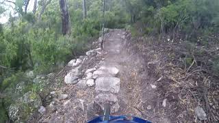
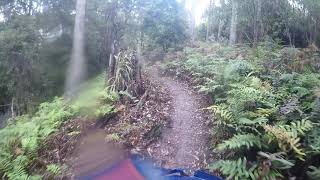
Popular Dial Range Mountain Biking Trails
• 100 ★ 4.4 • 4 miles • 533 ft • 457 •
The is the first official MTB trail in the Dial Range. At about 6km in length with easy grading, this trail is an awesome introduction to the Dial Range and can be ridden in combination with the trails of the Penguin MTB park. This...
• 100 ★ 4.7 • 2 miles • 114 ft • 425 •
is a bolder strewn, berm filled, adrenaline pumping descent that leads you back onto the from the and the climb trail. The Trail is a dark blue rated trail with black features. Caution is need for less experienced riders or sending it...
• 95 ★ 4.0 • 2 miles • 757 ft • 393 •
This trail takes you from the up to the intersection of the trail and the trail. It is a solid climb but the stunning views from the and awesome descent of will make it all worth while.
• 100 ★ 3.0 • 564 ft • 0 ft • 355 •
The View trail veers off the trail and climbs to a spectacular lookout. It then rejoins after descending off the high point.
• 95 ★ 4.6 • 4,701 ft • 335 ft • 280 •
The trail will lead you from the Climb and continue the climb to the Mount Dial Summit. Some of the best MTB trail views out to the west can be had from three lookouts along the trail as well at the view out to the east from the summit...
• 5 ★ 0.0 • 0 ft • 0 ft • 1 •
Less popular blue difficulty singletrack. This mountain bike primary trail can be used both directions and has a moderate overall physical rating with a 0 ft blue climb. It features berm. Trail visibility is always easy to follow.
Dial Range Mountain Bike Routes
5 miles • 1,162 ft • 1 • Out & Back • Race •
A challenging climb and a super fast and fun descent. The descent is regularly used as a stage of the Tas...
• 8 miles • 1,530 ft • 6 •
• 10 miles • 2,054 ft • 8 •
• 7 miles • 1,043 ft • 1 •
• 5 miles • 796 ft • 1 •
• 4 miles • 619 ft • 1 •
Photos of Dial Range Mountain Bike
Videos of Dial Range Mountain Bike

trail: Montgomery Loop
6:17 |
125 |
Sep 30, 2019

trail: Ironcliffe Ridge
9:23 |
154 |
Apr 19, 2023 , Penguin

trail: Iron Tor
9:23 |
267 |
Apr 19, 2023 , Penguin

trail: Iron Tor
7:57 |
283 |
Feb 8, 2023 , Penguin

trail: Iron Tor
6:20 |
238 |
Jan 26, 2023 , Penguin
trail: Ironcliffe Ridge
16:12 |
371 |
Dec 12, 2020 , Penguin

trail: Iron Tor
4:16 |
554 |
Dec 10, 2020 , Penguin
trail: Iron Tor (Climb)
18:59 |
319 |
Dec 10, 2020 , Penguin
Recent Trail Reports
| status | trail | date | condition | info | user |
|---|---|---|---|---|---|
| Iron Tor view trail | May 24, 2026 @ 3:13pm (Australia/Hobart) May 23, 2026 | Ideal | streddaz CCMBC | ||
| Iron Tor | May 24, 2026 @ 3:13pm (Australia/Hobart) May 23, 2026 | Ideal | streddaz CCMBC | ||
| Iron Tor (Climb) | May 24, 2026 @ 3:13pm (Australia/Hobart) May 23, 2026 | Ideal | streddaz CCMBC | ||
| Ironcliffe Ridge | Feb 8, 2026 @ 9:23am (Australia/Hobart) Feb 7, 2026 | Ideal | streddaz CCMBC | ||
| Montgomery Loop | Oct 12, 2025 @ 8:47am (Australia/Hobart) Oct 11, 2025 | Ideal | streddaz CCMBC | ||
| Hales Road (Gnomon to Duncan carparks) | Oct 4, 2025 @ 6:54am (Australia/Hobart) Oct 3, 2025 | Variable | streddaz CCMBC | ||
| Monty Short Link | Sep 21, 2025 @ 12:29pm (Australia/Hobart) Sep 20, 2025 | Variable | streddaz CCMBC | ||
| Dial Creek Track | Dec 26, 2024 @ 10:09am Dec 26, 2024 | Variable | streddaz CCMBC | ||
| Bannons Bridge Track | Jul 29, 2024 @ 8:41pm Jul 29, 2024 | Wet | streddaz CCMBC | ||
| Dial Road | May 11, 2024 @ 2:07am May 11, 2024 | Ideal | streddaz CCMBC |
Activity Feed
| username | action | type | title | date |
|---|---|---|---|---|
| streddaz | add | report | activity #95383503 and 2 more | May 24, 2026 @ 12:53am May 24, 2026 |
| streddaz | add | report | activity #91251707 and 1 more | Mar 25, 2026 @ 1:42am Mar 25, 2026 |
| streddaz | comment | trail | activity #90841926 and 1 more | Mar 18, 2026 @ 11:39pm Mar 18, 2026 |
| toquerider | ridden | trail | activity #90835768 and 3 more | Mar 18, 2026 @ 6:59pm Mar 18, 2026 |
| toquerider | comment | trail | activity #90835756 and 1 more | Mar 18, 2026 @ 6:59pm Mar 18, 2026 |
Recent Comments
| username | type | title | comment | date |
|---|---|---|---|---|
| trail | You shouldn’t be riding the walking track... | Mar 18, 2026 @ 11:42pm Mar 18, 2026 | ||
| trail | It definitely fits within the IMBA guidelines... | Mar 18, 2026 @ 11:39pm Mar 18, 2026 | ||
| trail | Expect a rocky technical descent. The "blue"... | Mar 18, 2026 @ 7:05pm Mar 18, 2026 | ||
| trail | Rocky and brutish. Except for the steps, the... | Mar 18, 2026 @ 6:59pm Mar 18, 2026 | ||
| trail | Unreal track with great rock tech and optional... | Feb 20, 2025 @ 11:07pm Feb 20, 2025 |
Nearby Areas
| name | distance | ||||
|---|---|---|---|---|---|
| Penguin MTB Park | 5 | 5 | 3.7 km | ||
| Stubb's Road | 3 | 2 | 9.2 km | ||
| Kelcey Tier | 11 | 9 | 3 | 14.7 km | |
| Winterbrook Falls Regional Reserve | 1 | 18.2 km | |||
| Wild Mersey | 5 | 3 | 1 | 21.3 km |
Activity Type Stats
| activitytype | trails | distance | descent | descent distance | total vertical | rating | global rank | state rank | photos | reports | routes | ridelogs |
|---|---|---|---|---|---|---|---|---|---|---|---|---|
| Mountain Bike | 48 | 12 miles | 2,831 ft | 5 miles | 1,299 ft | #4,818 | #237 | 87 | 310 | 1 | 1,573 | |
| E-Bike | 30 | 12 miles | 3,150 ft | 6 miles | 1,299 ft | #4,415 | #222 | 282 | 315 | |||
| Horse | 6 | 6 miles | 1,056 ft | 2 miles | 1,289 ft | #1,069 | #42 | 9 | ||||
| Hike | 52 | 20 miles | 6,644 ft | 10 miles | 2,087 ft | #5,521 | #158 | 292 | 87 | |||
| Trail Running | 52 | 20 miles | 6,644 ft | 10 miles | 2,087 ft | #5,103 | #158 | 292 | 156 | |||
| Dirtbike/Moto | 6 | 6 miles | 1,056 ft | 2 miles | 1,289 ft | #288 | #10 | 9 | ||||
| ATV/ORV/OHV | 6 | 4 miles | 125 ft | 3,015 ft | 1,165 ft | #196 | #10 | 9 |
Frequently Asked Questions About Dial Range
▼
What are the highest rated mountain biking trails in Dial Range?
The highest rated mountain biking trails in Dial Range are:
- Iron Tor (4.5/5)
- Ironcliffe Ridge (4.3/5)
- Montgomery Loop (4.2/5)
- Iron Tor (Climb) (4/5)
- Iron Tor view trail (3.8/5)
▼
What is the best time of the year to ride in Dial Range?
Based on ride log data, the most popular months to ride in Dial Range are:
- February (26 activities)
- January (24 activities)
- December (22 activities)
▼
Where can I park to ride in Dial Range?
There are 3 parking locations listed in Dial Range. The most popular parking spots are: View all parking and trailhead locations on the map to plan your visit.
▼
What is the longest trail in Dial Range?
The longest trail in Dial Range is Montgomery Loop at 3.6 miles. View all trails sorted by distance.
Activities
Trails
- By SchrodingersGat
 MRTG & contributors
 - Admins: Sekt, SchrodingersGat, CCMBC
- #9782 - 11,820 views
- dial range activity log | embed map of Dial Range mountain bike trails | dial range mountain biking points of interest
Downloading of trail gps tracks in kml & gpx formats is enabled for Dial Range.
You must login to download files.