close
-
Layers w
- Weather Layers
- Pro
- Pro
- Pro
- Pro
- Pro
- Pro
- More Layers
- Pro
- Pro
- Pro
- Pro
-
Upgrade to

3D
Trail Conditions
- Unknown
- Snow Groomed
- Snow Packed
- Snow Covered
- Snow Cover Partial
- Freeze/thaw Cycle
- Icy
- Prevalent Mud
- Wet
- Variable
- Ideal
- Dry
- Very Dry
Trail Flow (Ridden Direction)
Trailforks scans users ridelogs to determine the most popular direction each trail is ridden. A good flowing trail network will have most trails flowing in a single direction according to their intension.
The colour categories are based on what percentage of riders are riding a trail in its intended direction.
The colour categories are based on what percentage of riders are riding a trail in its intended direction.
- > 96%
- > 90%
- > 80%
- > 70%
- > 50%
- < 50%
- bi-directional trail
- no data
Trail Last Ridden
Trailforks scans ridelogs to determine the last time a trail was ridden.
- < 2 days
- < 1 week
- < 2 weeks
- < 1 month
- < 6 months
- > 6 months
Trail Ridden Direction
The intended direction a trail should be ridden.
- Downhill Only
- Downhill Primary
- Both Directions
- Uphill Primary
- Uphill Only
- One Direction
Contribute Details
Colors indicate trail is missing specified detail.
- Description
- Photos
- Description & Photos
- Videos
Trail Popularity ?
Trailforks scans ridelogs to determine which trails are ridden the most in the last 9 months.
Trails are compared with nearby trails in the same city region with a possible 25 colour shades.
Think of this as a heatmap, more rides = more kinetic energy = warmer colors.
- most popular
- popular
- less popular
- not popular
ATV/ORV/OHV Filter
Max Vehicle Width
inches
US Cell Coverage
Legend

Radar Time
Activity Recordings
Trailforks uses anonymized public activity data.
?
Activity Recordings
Trailforks uses anonymized public activity data.
?
Personal Heatmap
▶
Activity Types
all
/
none
▶
Options
2
Date range
month
–
Winter Trails
Warning
A routing network for winter maps does not exist. Selecting trails using the winter trails layer has been disabled.
Missing Trails
Most Popular
Least Popular
Trails are colored based on popularity. The more popular a trail is, the more red. Less popular trails trend towards green.
Jump Magnitude Heatmap
Heatmap of where riders jump on trails. Zoom in to see individual jumps, click circles to view jump details.
BC Backroad Status
![map legend]()
Service Road Atlas is a free to use, community-driven service for viewing and creating reports on the numerous back-country service roads around B.C. and Alberta.

Slope Aspect
Direction the slope faces
Trails Deemphasized
Trails are shown in grey.
Only show trails with no bike usage.
Suggested Layers
Based on selected activity type
Save the current map location and zoom level as your default home location whenever this page is loaded.
Save
No description for Killingly has been added yet!
Login or register to submit one.
Activities Click to view
- Mountain Bike
55 trails
- E-Bike
9 trails
- Gravel Bike
0 trails
- Winter Fat Bike
0 trails
- Hike
59 trails
- Trail Running
59 trails
- Snowshoe
46 trails
Region Details
- 11
- 16
- 20
- 6
- 2
Region Status
Caution as of May 8, 2026Stats
- Avg Trail Rating
- Trails (view details)
- 60
- Trails Mountain Bike
- 55
- Trails E-Bike
- 9
- Trails Hike
- 59
- Trails Trail Running
- 59
- Trails Snowshoe
- 46
- Total Distance
- 31 miles
- Total Descent Distance
- 13 miles
- Total Descent
- 1,956 ft
- Total Vertical
- 530 ft
- Highest Trailhead
- 666 ft
- Reports
- 409
- Photos
- 115
- Ridden Counter
- 4,425
Sub Regions
-
Old Furnace State Park
- 8
- 10
- 6
- 2
-
Quinebaug River Trail
- 7
- 9
Popular Killingly Mountain Biking Trails
• 100 ★ 0.0 • 1,181 ft • 0 ft • 212 •
Popular green difficulty doubletrack. This multi-use trail can be used both directions. On average it takes 1 minutes to complete this trail.
• 95 ★ 0.0 • 988 ft • 10 ft • 210 •
Popular blue difficulty singletrack. This multi-use trail can be used both directions and has a easy overall physical rating with a 10 ft green climb. It features bridge. Trail visibility is always easy to follow. On average it takes 2 minutes to complete this trail.
• 95 ★ 3.8 • 1 mile • 125 ft • 191 •
Popular black diamond difficulty singletrack. This multi-use trail can be used both directions with a 125 ft blue climb. It features berm, drop, jump, log ride, rock garden and skinny. On average it takes 13 minutes to complete this trail.
• 90 ★ 0.0 • 981 ft • 16 ft • 172 •
Popular black diamond difficulty singletrack. This multi-use trail can be used both directions and has a hard overall physical rating. It features rock garden. On average it takes minutes to complete this trail.
• 85 ★ 0.0 • 561 ft • 5 ft • 168 •
Popular green difficulty singletrack. This multi-use trail can be used both directions. On average it takes 1 minutes to complete this trail.
• 55 ★ 0.0 • 643 ft • 13 ft • 165 •
Moderately popular green difficulty singletrack. This multi-use trail can be used both directions. On average it takes 3 minutes to complete this trail.
• 35 ★ 2.0 • 2 miles • 126 ft • 165 •
Less popular black diamond difficulty singletrack. This multi-use trail can be used downhill primary. It features jump, log ride, skinny and other. On average it takes 19 minutes to complete this trail.
• 100 ★ 0.0 • 1,260 ft • 29 ft • 164 •
Popular black diamond difficulty singletrack. This multi-use trail can be used both directions with a 29 ft black diamond climb. On average it takes 7 minutes to complete this trail.
Killingly Mountain Bike Routes
11 miles • 242 ft • 18 • Loop •
Mutli use trails through Danielson and Brooklyn, CT. Some bridges over water.
8 miles • 902 ft • 14 •
2024 advanced loop for the fun ride. Remember: miles count double!
6 miles • 542 ft • 9 •
2024 intermediate loop for the fun ride. Remember: miles count double!
6 miles • 566 ft • 11 • Loop •
They don't lie when they say "miles count double" at Old Furnace. This short loop is a good "taste" of...
8 miles • 828 ft • 21 • Loop •
Good loop that includes all the good stuff. You could loop in but personally I don't think it is worth it....
7 miles • 782 ft • 23 • Loop •
This is the first loop I did out there except I didn't do Tom Foolery until the next day. The loop will...
Photos of Killingly Mountain Bike
Videos of Killingly Mountain Bike
youtuber
![The Best of Old Furnace MTB // 2023]()

13:32 |
201 |
Feb 17, 2023
youtuber
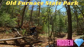
![A Hidden CT Gem! Old Furnace State Park]()
5:42 |
284 |
Jan 16, 2022

0:59 |
411 |
Jul 1, 2020 , Killingly

trail: Down To Earth
2:04 |
380 |
Aug 30, 2008
Recent Trail Reports
| status | trail | date | condition | info | user |
|---|---|---|---|---|---|
| Haunted Hollow | May 8, 2026 @ 8:20pm (America/New_York) May 8, 2026 | Unknown | Fatbiker77 | ||
| Orange Crush | May 7, 2026 @ 6:08pm (America/New_York) May 7, 2026 | Unknown | Fatbiker77 | ||
| HH/Orange Connector | Apr 28, 2026 @ 6:33pm (America/New_York) Apr 28, 2026 | Dry | Heethr QC NEMBA | ||
| 395 Trail | Apr 13, 2026 @ 6:42pm (America/New_York) Apr 13, 2026 | Unknown | Shadowdrums | ||
| Tomfoolery | Apr 11, 2026 @ 11:30am (America/New_York) Apr 11, 2026 | Unknown | Fatbiker77 | ||
| Riverside Singletrack V2 (North) | Mar 20, 2026 @ 12:36pm (America/New_York) Mar 20, 2026 | Unknown | Shadowdrums | ||
| Access Trail | Nov 4, 2025 @ 7:26pm (America/New_York) Nov 4, 2025 | Ideal | Heethr QC NEMBA | ||
| South Pond Loop | Nov 4, 2025 @ 6:49pm (America/New_York) Nov 4, 2025 | Ideal | Heethr QC NEMBA | ||
| Fern Gulley | Nov 2, 2025 @ 5:33pm (America/New_York) Nov 2, 2025 | Ideal | Heethr QC NEMBA | ||
| Access trail from RT6 to parking lot | Nov 2, 2025 @ 5:33pm (America/New_York) Nov 2, 2025 | Ideal | Heethr QC NEMBA |
National Scenic Trails & Official Routes
-
North-South Trail
- Mountain Bike
- Hike
- Trail Running
- Snowshoe
- Nordic Ski
Activity Feed
| username | action | type | title | date |
|---|---|---|---|---|
| brme4312 | wishlist | region | activity #94669061 | May 13, 2026 @ 9:26pm May 13, 2026 |
| Fatbiker77 | add | report | activity #94291436 | May 8, 2026 @ 5:20pm May 8, 2026 |
| Fatbiker77 | add | report | activity #94243829 | May 7, 2026 @ 3:08pm May 7, 2026 |
| Heethr | add | report | activity #93609182 and 2 more | Apr 28, 2026 @ 3:33pm Apr 28, 2026 |
| Shadowdrums | add | report | activity #92561505 and 1 more | Apr 13, 2026 @ 3:22pm Apr 13, 2026 |
Recent Comments
| username | type | title | comment | date |
|---|---|---|---|---|
| report | Tree cut back off of trail | Dec 21, 2024 @ 6:56am Dec 21, 2024 | ||
| report | Thanks David! Will get on it. | Nov 17, 2024 @ 10:23am Nov 17, 2024 | ||
| trail | Not a trail, but an assembly of sidewalks and... | Oct 28, 2022 @ 11:07am Oct 28, 2022 | ||
| trail | what type of riding is it, jumps, rock rolls, etc | Jun 30, 2020 @ 10:04am Jun 30, 2020 | ||
| trail | Rode here first time with my son. Definilty... | Mar 22, 2020 @ 12:41pm Mar 22, 2020 |
Local Badges
-

10 Blue Trails57 awarded -

Epic Ride Climb 2k9 awarded -

Climbing 10k Badge11 awarded -

Climbing 100k Badge0 awarded -

Epic Ride Descent 2k9 awarded -

Descent 10k Badge11 awarded
Activity Type Stats
| activitytype | trails | distance | descent | descent distance | total vertical | rating | global rank | state rank | photos | reports | routes | ridelogs |
|---|---|---|---|---|---|---|---|---|---|---|---|---|
| Mountain Bike | 55 | 30 miles | 1,663 ft | 12 miles | 531 ft | #6,888 | #2,307 | 78 | 407 | 9 | 2,305 | |
| E-Bike | 9 | 9 miles | 223 ft | 4 miles | 184 ft | #7,865 | #2,380 | 298 | 3 | 57 | ||
| Hike | 59 | 31 miles | 1,952 ft | 13 miles | 531 ft | #3,329 | #1,169 | 37 | 409 | 4 | 410 | |
| Trail Running | 59 | 31 miles | 1,916 ft | 13 miles | 531 ft | #5,517 | #1,742 | 409 | 3 | 110 | ||
| Snowshoe | 46 | 20 miles | 1,588 ft | 7 miles | 404 ft | #827 | #383 | 91 | 3 | 16 |
Frequently Asked Questions About Killingly
▼
What are the best places to ride in Killingly?
Killingly has 4 areas to explore for mountain biking. The top rated areas are:
▼
What are the highest rated mountain biking trails in Killingly?
The highest rated mountain biking trails in Killingly are:
- DNR (4.1/5)
- Rejuvenation (4/5)
- Tomfoolery (3.9/5)
- South Pond Loop (3.7/5)
- Orange Crush (3.6/5)
▼
What is the best time of the year to ride in Killingly?
Based on ride log data, the most popular months to ride in Killingly are:
- June (78 activities)
- April (66 activities)
- November (59 activities)
▼
Where can I park to ride in Killingly?
There are 4 parking locations listed in Killingly. The most popular parking spots are: View all parking and trailhead locations on the map to plan your visit.
Activities
- By Herrluc79 & contributors
- Admins: HCH, NEMBAEXEC, QC NEMBA
- #14369 - 2,321 views
- killingly activity log | embed map of Killingly mountain bike trails | killingly mountain biking points of interest polygons
Downloading of trail gps tracks in kml & gpx formats is enabled for Killingly.
You must login to download files.