close
-
Layers w
- Weather Layers
- Pro
- Pro
- Pro
- Pro
- Pro
- Pro
- More Layers
- Pro
- Pro
- Pro
- Pro
-
Upgrade to

3D
Trail Conditions
- Unknown
- Snow Groomed
- Snow Packed
- Snow Covered
- Snow Cover Partial
- Freeze/thaw Cycle
- Icy
- Prevalent Mud
- Wet
- Variable
- Ideal
- Dry
- Very Dry
Trail Flow (Ridden Direction)
Trailforks scans users ridelogs to determine the most popular direction each trail is ridden. A good flowing trail network will have most trails flowing in a single direction according to their intension.
The colour categories are based on what percentage of riders are riding a trail in its intended direction.
The colour categories are based on what percentage of riders are riding a trail in its intended direction.
- > 96%
- > 90%
- > 80%
- > 70%
- > 50%
- < 50%
- bi-directional trail
- no data
Trail Last Ridden
Trailforks scans ridelogs to determine the last time a trail was ridden.
- < 2 days
- < 1 week
- < 2 weeks
- < 1 month
- < 6 months
- > 6 months
Trail Ridden Direction
The intended direction a trail should be ridden.
- Downhill Only
- Downhill Primary
- Both Directions
- Uphill Primary
- Uphill Only
- One Direction
Contribute Details
Colors indicate trail is missing specified detail.
- Description
- Photos
- Description & Photos
- Videos
Trail Popularity ?
Trailforks scans ridelogs to determine which trails are ridden the most in the last 9 months.
Trails are compared with nearby trails in the same city region with a possible 25 colour shades.
Think of this as a heatmap, more rides = more kinetic energy = warmer colors.
- most popular
- popular
- less popular
- not popular
ATV/ORV/OHV Filter
Max Vehicle Width
inches
US Cell Coverage
Legend

Radar Time
Activity Recordings
Trailforks uses anonymized public activity data.
?
Activity Recordings
Trailforks uses anonymized public activity data.
?
Personal Heatmap
▶
Activity Types
all
/
none
▶
Options
2
Date range
month
–
Winter Trails
Warning
A routing network for winter maps does not exist. Selecting trails using the winter trails layer has been disabled.
Missing Trails
Most Popular
Least Popular
Trails are colored based on popularity. The more popular a trail is, the more red. Less popular trails trend towards green.
Jump Magnitude Heatmap
Heatmap of where riders jump on trails. Zoom in to see individual jumps, click circles to view jump details.
BC Backroad Status
![map legend]()
Service Road Atlas is a free to use, community-driven service for viewing and creating reports on the numerous back-country service roads around B.C. and Alberta.

Slope Aspect
Direction the slope faces
Trails Deemphasized
Trails are shown in grey.
Only show trails with no bike usage.
Suggested Layers
Based on selected activity type
Save the current map location and zoom level as your default home location whenever this page is loaded.
Save
No description for La Table has been added yet!
Login or register to submit one.
This region uses the Uk/Euro style trail grading system.
Activities Click to view
- Mountain Bike
19 trails
- E-Bike
18 trails
- Adaptive Bike
- Horse
1 trails
- Hike
9 trails
- Trail Running
9 trails
- Dirtbike/Moto
0 trails
- Observed Trials
0 trails
- ATV/ORV/OHV
0 trails
Region Details
- 4
- 1
- 3
- 6
- 5
Region Status
Open as of Oct 8, 2025Stats
- Avg Trail Rating
- Trails (view details)
- 19
- Trails Mountain Bike
- 19
- Trails E-Bike
- 18
- Trails Horse
- 1
- Trails Hike
- 9
- Trails Trail Running
- 9
- Total Distance
- 25 miles
- Total Descent Distance
- 11 miles
- Total Descent
- 9,010 ft
- Total Vertical
- 5,085 ft
- Highest Trailhead
- 6,777 ft
- Reports
- 39
- Photos
- 36
- Ridden Counter
- 384
Popular La Table Mountain Biking Trails
• 80 ★ 4.5 • 1 mile • 0 ft • 31 • • hike
Partie final du single du Grand Chat. Des virages rélevés naturels en sous bois, des racines... super joueur!
• 85 ★ 0.0 • 4,180 ft • 0 ft • 29 • • hike
Super single en crête. Début joueur et facile suivi d'une partie avec pas mal de rochers, un petit peu d'exposition et de passage techniques avant d'entrer dans la forêt.
• 95 ★ 0.0 • 3,251 ft • 408 ft • 27 • • hike
Montée sur la . Possibilité de le faire dans les deux directions. En montée difficile de faire beaucoup sur le vélo, il faudra souvent pousser/porter le vélo ! Climb to la , It's possible to do it on both directions. When you climb...
• 90 ★ 0.0 • 2,139 ft • 8 ft • 26 • • hike
Super single en crête avec une vue incroyable sur le Mont Blanc. Très roulant et joueur. Nice singletrack on a ridge, with a 360 view all around ! Fun to ride !
• 75 ★ 0.0 • 876 ft • 0 ft • 26 •
Steep downhill, with some burms and jumps and steep chute ! Jolie sentier type dh, avec quelques virages sauts, de bonne rupture de pente !
• 100 ★ 0.0 • 528 ft • 0 ft • 24 • • hike
Short singletrack, nice turns, fun to ride, steeper than the other track Jolie sentier en variante du , virage sympa, de la pente ! Cool à rouler
• 35 ★ 5.0 • 2 miles • 2 ft • 16 • • hike
Super signle en forêt, suivant le GR. Alternative à la descente VTT noir qui descend tout droit dans le pentu.
• 55 ★ 0.0 • 3,783 ft • 4 ft • 15 • • hike
Descente sur la face nord du Chapotet. Début très joueur et agréable, suivi des parties assez expo et techniques. Attention aux randonneurs.
Photos of La Table Mountain Bike
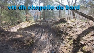
Videos of La Table Mountain Bike
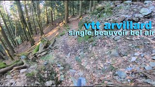
trail: descente beauvoir bel air
7:00 |
54 |
Mar 9, 2023 , La Table
8:03 |
122 |
Mar 9, 2023 , La Table
Recent Trail Reports
| status | trail | date | condition | info | user |
|---|---|---|---|---|---|
| Traversée du Grand Cucheron | Oct 8, 2025 @ 9:36am (Europe/Paris) Oct 8, 2025 | Variable | Petrus3888 | ||
| Descente Du Nant | Oct 8, 2025 @ 9:36am (Europe/Paris) Oct 8, 2025 | Variable | Petrus3888 | ||
| Single du Grand Chat - partie basse | Oct 8, 2025 @ 9:36am (Europe/Paris) Oct 8, 2025 | Variable | Petrus3888 | ||
| Liaison descente du Grand Chat | Oct 8, 2025 @ 9:36am (Europe/Paris) Oct 8, 2025 | Variable | Petrus3888 | ||
| La Richesse | Oct 8, 2025 @ 9:36am (Europe/Paris) Oct 8, 2025 | Variable | Petrus3888 | ||
| Refuge D'Arbarétan | Oct 8, 2025 @ 9:36am (Europe/Paris) Oct 8, 2025 | Variable | Petrus3888 | ||
| Vers L'Arbarétan | Oct 8, 2025 @ 9:36am (Europe/Paris) Oct 8, 2025 | Variable | Petrus3888 | ||
| Le Chapotet: face nord | Oct 8, 2025 @ 9:36am (Europe/Paris) Oct 8, 2025 | Variable | Petrus3888 | ||
| Montée ouest Chapotet | Oct 8, 2025 @ 9:36am (Europe/Paris) Oct 8, 2025 | Ideal | Petrus3888 | ||
| Montée du Bois Brûlé | Oct 8, 2025 @ 9:36am (Europe/Paris) Oct 8, 2025 | Ideal | Petrus3888 |
Activity Feed
| username | action | type | title | date |
|---|---|---|---|---|
| Petrus3888 | add | report | activity #81990665 and 10 more | Oct 9, 2025 @ 12:19am Oct 9, 2025 |
| matteofab | like | report | activity #73671864 | Jun 13, 2025 @ 4:41am Jun 13, 2025 |
| matteofab | wishlist | region | activity #73671707 | Jun 13, 2025 @ 4:34am Jun 13, 2025 |
| aurelsodouda | wishlist | trail | activity #50152430 and 2 more | Mar 18, 2024 @ 4:01am Mar 18, 2024 |
| judlp | add | report | activity #48638732 | Jan 28, 2024 @ 12:58pm Jan 28, 2024 |
Recent Comments
| username | type | title | comment | date |
|---|---|---|---|---|
| trail | Je voudrais apporter des précisions sur la... | Jul 31, 2023 @ 11:45am Jul 31, 2023 | ||
| trail | Magnifique single moins dur que le debut | Jan 31, 2023 @ 1:31pm Jan 31, 2023 | ||
| trail | Un vrai single dh assez difficile par endroit | Jan 31, 2023 @ 1:30pm Jan 31, 2023 | ||
| trail | A faire et refaire avec plaisir | Jan 31, 2023 @ 1:02am Jan 31, 2023 |
Local Badges
-

Epic Mountain Bike Climb 2k10 awarded -

Climbing 10k Badge1 awarded -

Mountain Biking 100k Badge0 awarded -

Epic Ride Descent 2k10 awarded -

Descent 10k Badge1 awarded -

Descent 100k Badge0 awarded
Bike & Skill Parks
| name | type | city | rating |
|---|---|---|---|
| pumptrack de St François Lonchamp | skill park | La Table |
Activity Type Stats
| activitytype | trails | distance | descent | descent distance | total vertical | rating | global rank | state rank | photos | reports | routes | ridelogs |
|---|---|---|---|---|---|---|---|---|---|---|---|---|
| Mountain Bike | 19 | 25 miles | 9,009 ft | 11 miles | 5,085 ft | #4,090 | #132 | 36 | 39 | 195 | ||
| E-Bike | 18 | 24 miles | 7,812 ft | 9 miles | 5,085 ft | #3,959 | #225 | 39 | 24 | |||
| Horse | 1 | 4,843 ft | 951 ft | 4,843 ft | 951 ft | #2,408 | #111 | 1 | ||||
| Hike | 9 | 12 miles | 3,734 ft | 4 miles | 4,823 ft | #7,060 | #264 | 39 | 40 | |||
| Trail Running | 9 | 12 miles | 3,734 ft | 4 miles | 4,823 ft | #7,390 | #310 | 39 | 9 |
Frequently Asked Questions About La Table
▼
What are the highest rated mountain biking trails in La Table?
The highest rated mountain biking trails in La Table are:
- GR du Grand Chat (4.1/5)
- Vtt Dh chapelle du bard partie 4 (4.1/5)
- descente beauvoir bel air (4.1/5)
- Single du Grand Chat - partie basse (4.1/5)
- Crête du Grand Chat (0/5)
▼
What is the best time of the year to ride in La Table?
Based on ride log data, the most popular months to ride in La Table are:
- February (2 activities)
- October (1 activities)
- June (1 activities)
▼
Where can I park to ride in La Table?
Check the La Table trail map for trailhead and parking information. Community members regularly update access and parking details for trails in the area.
▼
What is the longest trail in La Table?
The longest trail in La Table is Traversée Des Marais at 2.0 miles. View all trails sorted by distance.
Activities
Trails
Points of Interest
- By freerider48
 TRAILFORKS TFFRANCE & contributors
 - Admins: LSBP, freerider48, provencemb, fredhornybsm, Whipperman
- #36669 - 818 views
- la table activity log | embed map of La Table mountain bike trails |
Downloading of trail gps tracks in kml & gpx formats is enabled for La Table.
You must login to download files.