close
-
Layers w
- Weather Layers
- Pro
- Pro
- Pro
- Pro
- Pro
- Pro
- More Layers
- Pro
- Pro
- Pro
- Pro
-
Upgrade to

3D
Trail Conditions
- Unknown
- Snow Groomed
- Snow Packed
- Snow Covered
- Snow Cover Partial
- Freeze/thaw Cycle
- Icy
- Prevalent Mud
- Wet
- Variable
- Ideal
- Dry
- Very Dry
Trail Flow (Ridden Direction)
Trailforks scans users ridelogs to determine the most popular direction each trail is ridden. A good flowing trail network will have most trails flowing in a single direction according to their intension.
The colour categories are based on what percentage of riders are riding a trail in its intended direction.
The colour categories are based on what percentage of riders are riding a trail in its intended direction.
- > 96%
- > 90%
- > 80%
- > 70%
- > 50%
- < 50%
- bi-directional trail
- no data
Trail Last Ridden
Trailforks scans ridelogs to determine the last time a trail was ridden.
- < 2 days
- < 1 week
- < 2 weeks
- < 1 month
- < 6 months
- > 6 months
Trail Ridden Direction
The intended direction a trail should be ridden.
- Downhill Only
- Downhill Primary
- Both Directions
- Uphill Primary
- Uphill Only
- One Direction
Contribute Details
Colors indicate trail is missing specified detail.
- Description
- Photos
- Description & Photos
- Videos
Trail Popularity ?
Trailforks scans ridelogs to determine which trails are ridden the most in the last 9 months.
Trails are compared with nearby trails in the same city region with a possible 25 colour shades.
Think of this as a heatmap, more rides = more kinetic energy = warmer colors.
- most popular
- popular
- less popular
- not popular
ATV/ORV/OHV Filter
Max Vehicle Width
inches
US Cell Coverage
Legend

Radar Time
Activity Recordings
Trailforks uses anonymized public activity data.
?
Activity Recordings
Trailforks uses anonymized public activity data.
?
Personal Heatmap
▶
Activity Types
all
/
none
▶
Options
2
Date range
month
–
Winter Trails
Warning
A routing network for winter maps does not exist. Selecting trails using the winter trails layer has been disabled.
Missing Trails
Most Popular
Least Popular
Trails are colored based on popularity. The more popular a trail is, the more red. Less popular trails trend towards green.
Jump Magnitude Heatmap
Heatmap of where riders jump on trails. Zoom in to see individual jumps, click circles to view jump details.
BC Backroad Status
![map legend]()
Service Road Atlas is a free to use, community-driven service for viewing and creating reports on the numerous back-country service roads around B.C. and Alberta.

Slope Aspect
Direction the slope faces
Trails Deemphasized
Trails are shown in grey.
Only show trails with no bike usage.
Suggested Layers
Based on selected activity type
Save the current map location and zoom level as your default home location whenever this page is loaded.
Save
Activities Click to view
- Mountain Bike
295 trails
- E-Bike
72 trails
- Gravel Bike
0 trails
- Adaptive Bike
0 trails
- Winter Fat Bike
0 trails
- Horse
81 trails
- Hike
337 trails
- Trail Running
332 trails
- Snowshoe
43 trails
- Nordic Ski
51 trails
Region Details
- 42
- 4
- 76
- 80
- 66
- 10
Region Status
Caution as of Jun 4, 2026Stats
- Avg Trail Rating
- Trails (view details)
- 297
- Trails Mountain Bike
- 297
- Trails E-Bike
- 72
- Trails Horse
- 81
- Trails Hike
- 337
- Trails Trail Running
- 332
- Trails Snowshoe
- 43
- Trails Backcountry Ski
- 1
- Trails Nordic Ski
- 51
- Total Distance
- 154 miles
- Total Descent
- 21,680 ft
- Total Vertical
- 959 ft
- Highest Trailhead
- 1,115 ft
- Reports
- 5,648
- Photos
- 1,699
- Ridden Counter
- 63,867
Sub Regions
-
Antietam Lake Park
- 15
- 15
- 8
-
Blue Marsh Lake
- 8
- 15
- 1
-
Green Hills Preserve
- 8
- 1
-
Monocacy Hill
-
Mount Penn Preserve
- 1
- 24
- 33
- 56
- 9
-
Neversink Mountain Preserve
- 1
- 11
- 10
- 3
- 1
-
Reading Urban Trails
- 2
- 4
Popular Reading Mountain Biking Trails
• 90 ★ 3.7 • 4,790 ft • 43 ft • 1,180 •
Fast, tight, winding single track with some punchy, short up hills.
• 100 ★ 4.0 • 2 miles • 187 ft • 758 •
Two miles of fun, machine-built flow trail between the Lower Stilling Basin Parking Lot and the Water Road Parking Lot. Built by DirtSculpt as part of BAMBA's Blue Marsh Trail Restoration Project-Phase 2, in partnership with USACE.
• 95 ★ 4.4 • 3,491 ft • 0 ft • 757 •
Constructed dirt jump trail. Upper section is very rocky until you get to the log drop (4-6ft), middle section is packed dirt and shale with several dirt drops (1-2ft), rollers, and berms. Lower section is packed dirt with large tables,...
• 100 ★ 3.0 • 875 ft • 6 ft • 711 •
Feeder trail from/to BAMBA lot. Meets up with south of the lot.
• 100 ★ 4.6 • 4 miles • 330 ft • 612 •
This trail is dedicated in memory to cyclist, Loren Holl. Machine-built flowy trail providing more fun options by the State Hill Boat Launch area. This trail was built by as part of 's Blue Marsh Trail Restoration Project-Phase 3, in...
• 90 ★ 3.8 • 1,033 ft • 0 ft • 599 •
Packed dirt singletrack with several 8-12" rock ledges. please be mindful of people ripping down this if you are climbing up.
• 100 ★ 3.5 • 2,575 ft • 38 ft • 595 •
New singletrack machine built flow trail that runs parallel to the old . Runs from Old State Hill Road to near Dike C
• 100 ★ 4.5 • 541 ft • 10 ft • 579 •
just a simple trail that allows you to bypass pushing back up a jump line.
Reading Mountain Bike Routes
9 miles • 608 ft • 4 • Out & Back •
This route starts at the State Hill Boat Launch parking area and hits all of the new mountain bike trails...
13 miles • 515 ft • 3 • Loop •
Gibraltar, Exeter Scenic Trail and Neversink loop for the Berks Bike Ramble 2021 *please note: the start...
★ 4.5 • 7 miles • 843 ft • 77 • Point to Point •
Tried to build the rockiest route I could down the mountain. This route is extremely rocky and gnarly and...
★ 4.0 • 2 miles • 189 ft • 13 •
Easy Loop from BAMBA Lot - to Ferndale
★ 3.5 • 5 miles • 921 ft • 18 •
Route from Exeter Scenic Path to McElvain Pavilion on easy paths. Turn around or try the intermediate...
7 miles • 891 ft • 11 • Loop •
Intermediate loop for the Berks Bike Ramble 2021
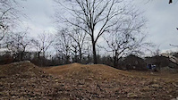
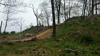
Photos of Reading Mountain Bike
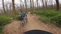
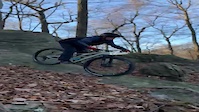
Videos of Reading Mountain Bike
trail: Boomsauce (Lower)
0:11 |
30 |
May 28, 2025
trail: Skyline
0:14 |
350 |
Apr 17, 2023
trail: Skyline
0:45 |
334 |
Dec 31, 2022
trail: Rocky Rotary 2
0:15 |
178 |
Nov 18, 2020
trail: Deer Head
0:43 |
257 |
Aug 5, 2020
trail: Stage 3
0:16 |
457 |
Mar 8, 2020
trail: Stage 3
2:46 |
275 |
Sep 25, 2016
trail: Stage 3
0:14 |
333 |
Jun 12, 2016
Current Trail Warnings
| status | trail | date | condition | user | info |
|---|---|---|---|---|---|
| State Hill Loop | May 28, 2026 @ 5:12pm (America/New_York) May 28, 2026 | Unknown | CoalIronScrap | tree down blocking trail |
Recent Trail Reports
| status | trail | date | condition | info | user |
|---|---|---|---|---|---|
| Sting Like a Bee | Jun 4, 2026 @ 3:24pm (America/New_York) Jun 4, 2026 | Unknown | jsharrison1 BAMBA | ||
| Red Trail | Jun 3, 2026 @ 9:44am (America/New_York) Jun 3, 2026 | Ideal | jesslp2401 | ||
| Twisted Sister | May 31, 2026 @ 1:41pm (America/New_York) May 31, 2026 | Ideal | JasonzrTzp8 | ||
| Boomsauce (Lower) | May 31, 2026 @ 1:41pm (America/New_York) May 31, 2026 | Ideal | JasonzrTzp8 | ||
| Boomsauce (Upper) | May 31, 2026 @ 1:41pm (America/New_York) May 31, 2026 | Ideal | JasonzrTzp8 | ||
| Climb Trail from Fruit Farm | May 31, 2026 @ 1:41pm (America/New_York) May 31, 2026 | Ideal | JasonzrTzp8 | ||
| Wizard of Oz | May 31, 2026 @ 1:41pm (America/New_York) May 31, 2026 | Ideal | JasonzrTzp8 | ||
| Wizard of Oz branch. | May 31, 2026 @ 1:41pm (America/New_York) May 31, 2026 | Ideal | JasonzrTzp8 | ||
| Angora Road Trailhead to Fruit Farm | May 31, 2026 @ 1:41pm (America/New_York) May 31, 2026 | Ideal | JasonzrTzp8 | ||
| Tulpy Flow Trail | May 27, 2026 @ 7:03pm (America/New_York) May 27, 2026 | Unknown | theLark |
Activity Feed
| username | action | type | title | date |
|---|---|---|---|---|
| Aut3nWJ | wishlist | route | activity #96556671 | Jun 8, 2026 @ 12:16pm 16 hours |
| rondixon | add | karma | activity #96530468 | Jun 8, 2026 @ 4:29am 23 hours |
| jsharrison1 | comment | report | activity #96389230 | Jun 6, 2026 @ 11:05am 3 days |
| 1kmjennings | ridden | trail | activity #96379360 | Jun 6, 2026 @ 9:25am 3 days |
| jsharrison1 | add | report | activity #96245441 | Jun 4, 2026 @ 12:24pm Jun 4, 2026 |
Recent Comments
| username | type | title | comment | date |
|---|---|---|---|---|
| report | 3 trees down | Jun 6, 2026 @ 11:05am 3 days | ||
| report | 3 total lowdown trees in this section on... | Apr 6, 2026 @ 2:28pm Apr 6, 2026 | ||
| report | This was already cleared when I rode tonight. | Oct 3, 2025 @ 6:26pm Oct 3, 2025 | ||
| report | Tree is at the last switch back heading toward... | Sep 30, 2025 @ 5:01pm Sep 30, 2025 | ||
| report | Thanks, Mitch. I'll bring a chainsaw out tomorrow. | Sep 30, 2025 @ 1:00pm Sep 30, 2025 |
Local Badges
-

10 Green Trails366 awarded -

Descent 100k Badge9 awarded -

Epic Ride 50k848 awarded -

10 Expert Trails71 awarded -

Completionist0 awarded -

Big Ride 30k1,823 awarded
Bike & Skill Parks
| name | type | city | rating |
|---|---|---|---|
| Blue Marsh Bike Skills Area | skill park | Reading |
Activity Type Stats
| activitytype | trails | distance | descent | descent distance | total vertical | rating | global rank | state rank | photos | reports | routes | ridelogs |
|---|---|---|---|---|---|---|---|---|---|---|---|---|
| Mountain Bike | 295 | 144 miles | 19,865 ft | 59 miles | 958 ft | #184 | #70 | 1,685 | 5,671 | 19 | 41,407 | |
| E-Bike | 72 | 42 miles | 4,705 ft | 17 miles | 912 ft | #2,494 | #1,007 | 1 | 3,691 | 2 | 3,046 | |
| Horse | 81 | 51 miles | 6,398 ft | 21 miles | 758 ft | #870 | #609 | 2,452 | 5 | |||
| Hike | 337 | 151 miles | 21,296 ft | 63 miles | 958 ft | #303 | #148 | 17 | 5,587 | 1,980 | ||
| Trail Running | 332 | 150 miles | 20,843 ft | 62 miles | 958 ft | #647 | #241 | 1 | 5,581 | 2 | 1,702 | |
| Snowshoe | 43 | 42 miles | 3,825 ft | 17 miles | 308 ft | #441 | #141 | 298 | 10 | |||
| Backcountry Ski | 1 | 4 miles | 413 ft | 2 miles | 164 ft | 47 | 3 | |||||
| Nordic Ski | 51 | 43 miles | 4,377 ft | 18 miles | 607 ft | #483 | #145 | 250 | 23 |
Frequently Asked Questions About Reading
▼
What are the best places to ride in Reading?
Reading has 9 areas to explore for mountain biking. The top rated areas are:
▼
What are the highest rated mountain biking trails in Reading?
The highest rated mountain biking trails in Reading are:
- Dane's Run (4.5/5)
- Too Fast Kids (4.4/5)
- Loren Holl Memorial Loop (4.3/5)
- The Bowl perimeter trail (4.3/5)
- Boomsauce (Lower) (4.3/5)
▼
What is the best time of the year to ride in Reading?
Based on ride log data, the most popular months to ride in Reading are:
- July (492 activities)
- August (412 activities)
- September (400 activities)
▼
Where can I park to ride in Reading?
There are 34 parking locations listed in Reading. The most popular parking spots are: View all parking and trailhead locations on the map to plan your visit.
Activities
Trails
Points of Interest
- By brenthillier
 NSMBA TRAILFORKS & contributors
 - Admins: BAMBA
- #5657 - 23,145 views
- reading activity log | embed map of Reading mountain bike trails | reading mountain biking points of interest polygons
Downloading of trail gps tracks in kml & gpx formats is enabled for Reading.
You must login to download files.