close
-
Layers w
- Weather Layers
- Pro
- Pro
- Pro
- Pro
- Pro
- Pro
- More Layers
- Pro
- Pro
- Pro
- Pro
-
Upgrade to

3D
Trail Conditions
- Unknown
- Snow Groomed
- Snow Packed
- Snow Covered
- Snow Cover Partial
- Freeze/thaw Cycle
- Icy
- Prevalent Mud
- Wet
- Variable
- Ideal
- Dry
- Very Dry
Trail Flow (Ridden Direction)
Trailforks scans users ridelogs to determine the most popular direction each trail is ridden. A good flowing trail network will have most trails flowing in a single direction according to their intension.
The colour categories are based on what percentage of riders are riding a trail in its intended direction.
The colour categories are based on what percentage of riders are riding a trail in its intended direction.
- > 96%
- > 90%
- > 80%
- > 70%
- > 50%
- < 50%
- bi-directional trail
- no data
Trail Last Ridden
Trailforks scans ridelogs to determine the last time a trail was ridden.
- < 2 days
- < 1 week
- < 2 weeks
- < 1 month
- < 6 months
- > 6 months
Trail Ridden Direction
The intended direction a trail should be ridden.
- Downhill Only
- Downhill Primary
- Both Directions
- Uphill Primary
- Uphill Only
- One Direction
Contribute Details
Colors indicate trail is missing specified detail.
- Description
- Photos
- Description & Photos
- Videos
Trail Popularity ?
Trailforks scans ridelogs to determine which trails are ridden the most in the last 9 months.
Trails are compared with nearby trails in the same city region with a possible 25 colour shades.
Think of this as a heatmap, more rides = more kinetic energy = warmer colors.
- most popular
- popular
- less popular
- not popular
ATV/ORV/OHV Filter
Max Vehicle Width
inches
US Cell Coverage
Legend

Radar Time
Activity Recordings
Trailforks uses anonymized public activity data.
?
Activity Recordings
Trailforks uses anonymized public activity data.
?
Personal Heatmap
▶
Activity Types
all
/
none
▶
Options
2
Date range
month
–
Winter Trails
Warning
A routing network for winter maps does not exist. Selecting trails using the winter trails layer has been disabled.
Missing Trails
Most Popular
Least Popular
Trails are colored based on popularity. The more popular a trail is, the more red. Less popular trails trend towards green.
Jump Magnitude Heatmap
Heatmap of where riders jump on trails. Zoom in to see individual jumps, click circles to view jump details.
BC Backroad Status
![map legend]()
Service Road Atlas is a free to use, community-driven service for viewing and creating reports on the numerous back-country service roads around B.C. and Alberta.

Slope Aspect
Direction the slope faces
Trails Deemphasized
Trails are shown in grey.
Only show trails with no bike usage.
Suggested Layers
Based on selected activity type
Save the current map location and zoom level as your default home location whenever this page is loaded.
Save
No description for Third Flats has been added yet!
Login or register to submit one.
 google parking directions
google parking directions Activities Click to view
- Mountain Bike
30 trails
- E-Bike
27 trails
- Horse
5 trails
- Hike
32 trails
- Trail Running
32 trails
- Dirtbike/Moto
27 trails
- Observed Trials
6 trails
- ATV/ORV/OHV
21 trails
Region Details
- 5
- 3
- 17
- 4
Region Status
Open as of Mar 21, 2026Stats
- Avg Trail Rating
- Trails (view details)
- 31
- Trails Mountain Bike
- 30
- Trails E-Bike
- 27
- Trails Horse
- 5
- Trails Hike
- 32
- Trails Trail Running
- 32
- Trails Dirtbike/Moto
- 27
- Trails Observed Trials
- 6
- Trails ATV/ORV/OHV
- 21
- Total Distance
- 79 miles
- Total Descent
- 12,375 ft
- Total Vertical
- 2,656 ft
- Highest Trailhead
- 7,261 ft
- Reports
- 142
- Photos
- 35
- Ridden Counter
- 4,929
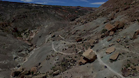
Popular Third Flats Mountain Biking Trails
• 90 ★ 3.3 • 4,261 ft • 216 ft • 946 •
Half of a loop from First Flats Trailhead that takes riders and hikers right to the boundary of the rized zone and makes a nice connection with the rized loop via a short connector. This trail winds through rocky P/J Forest, through a...
• 75 ★ 4.0 • 4,719 ft • 268 ft • 575 •
This is the first half of the motorized singletrack trail, . It was constructed at the end of 2017 by MTRA and makes a nice connector from Twist-n-Shout to Snake Skin. It can be continued with Bottom back to Twist-n-Shout near the...
• 65 ★ 3.8 • 6 miles • 976 ft • 466 •
The singletrack trail is a motorized, motorcycle trail that was built with state motorized funds and is a great example of a motorized trail that is a great mountain bike trail. Please be aware that you may see motorcycles on the trail,...
• 65 ★ 4.2 • 3 miles • 228 ft • 316 • • moto
This is the second half of the motorized singletrack trail, . It was constructed at the end of 2017 by MTRA and makes a nice connector from to . It can be continued from or connected to from the short connector that comes from .
• 60 ★ 2.9 • 2 miles • 443 ft • 247 • • moto
Moderately popular blue difficulty doubletrack. This dirtbike/moto primary trail can be used downhill primary. Adaptive MTB rating: amtb green. On average it takes 17 minutes to complete this trail.
• 30 ★ 4.5 • 8 miles • 366 ft • 155 •
This wonderful new, motorized singletrack trail (2020) parallels Road, but you will never see the road until you rejoin it, and the views are amazing. Instead of staying on the plain, it stays near the canyon edge, sometimes crossing...
• 75 ★ 3.0 • 587 ft • 0 ft • 129 • • moto
Popular black diamond difficulty doubletrack. This dirtbike/moto primary trail can be used both directions. Adaptive MTB rating: amtb blue. On average it takes minutes to complete this trail.
• 60 ★ 3.0 • 820 ft • 0 ft • 122 • • moto
Moderately popular blue difficulty singletrack. This dirtbike/moto primary trail can be used both directions. On average it takes minutes to complete this trail.
Third Flats Mountain Bike Routes
10 miles • 830 ft • 6 •
AKA Gunny Shuttle. A shuttled ride from Third Flats Trailhead back to the main Lunch Loops Parking lot....
26 miles • 3,941 ft • 2 • Loop •
Great ebike loop with first 10 mi all singletrack, losing ~1300'. Then it's some pretty awesome views on...
★ 1.5 • 19 miles • 2,859 ft • 7 •
This is an e-bike preferred route, although it is used by both mt bikes and motos. It is mostly single...
15 miles • 2,133 ft • 25 • Loop •
This route is ORV/Moto, both 2 and single track, ideal for e-mtb or a strong traditional mtb'r. It starts...
8 miles • 1,121 ft • 2 • Loop •
Third Flats is one of the only areas around Grand Junction that allows eBIkes. This is an easy loop for...
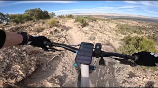
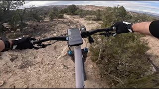
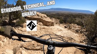
Photos of Third Flats Mountain Bike
Videos of Third Flats Mountain Bike

trail: Butterknife
3:56 |
105 |
Dec 18, 2018
trail: Butterknife
3:51 |
3592 |
Jul 14, 2015
trail: Snake Skin
5:45 |
34 |
Nov 9, 2025 , Grand Junction
trail: Good Vibes
4:32 |
46 |
Nov 8, 2025 , Grand Junction
trail: Butterknife
29:22 |
154 |
Apr 28, 2025 , Grand Junction

trail: Quad Rocker Loop
2:50 |
248 |
Mar 25, 2021 , Grand Junction

trail: Rocky Stumble
2:58 |
229 |
Mar 25, 2021 , Grand Junction
Recent Trail Reports
| status | trail | date | condition | info | user |
|---|---|---|---|---|---|
| Butterknife | Mar 21, 2026 @ 8:33am (America/Denver) Mar 21, 2026 | Very Dry | loamersonly | ||
| Twist-n-shout | Mar 21, 2026 @ 8:33am (America/Denver) Mar 21, 2026 | Very Dry | loamersonly | ||
| Second Thoughts | Mar 21, 2026 @ 8:33am (America/Denver) Mar 21, 2026 | Very Dry | loamersonly | ||
| Snake Skin | Mar 14, 2026 @ 11:08am (America/Denver) Mar 14, 2026 | Very Dry | loamersonly | ||
| Good Vibes | Mar 14, 2026 @ 11:08am (America/Denver) Mar 14, 2026 | Very Dry | loamersonly | ||
| RAMPAGE | Nov 12, 2025 @ 10:25am (America/Denver) Nov 12, 2025 | Ideal | loamersonly | ||
| Quad Rocker | Nov 12, 2025 @ 10:25am (America/Denver) Nov 12, 2025 | Ideal | loamersonly | ||
| Canyon View | Sep 5, 2025 @ 5:09pm Sep 5, 2025 | Ideal | Joelsu78iV | ||
| Roll Over Ridge | Sep 5, 2025 @ 5:09pm Sep 5, 2025 | Ideal | Joelsu78iV | ||
| Easy Rider | Sep 5, 2025 @ 5:09pm Sep 5, 2025 | Ideal | Joelsu78iV |
Activity Feed
| username | action | type | title | date |
|---|---|---|---|---|
| ShannonTupaa7S | ridden | trail | activity #95782763 | May 29, 2026 @ 9:20am May 29, 2026 |
| snagcliffs | vote | trail | activity #94527580 and 4 more | May 11, 2026 @ 5:15pm May 11, 2026 |
| snagcliffs | comment | trail | activity #94527521 | May 11, 2026 @ 5:14pm May 11, 2026 |
| wheresjono | ridden | trail | activity #94464399 | May 10, 2026 @ 3:34pm May 10, 2026 |
| snagcliffs | add | photo | activity #94450839 and 1 more | May 10, 2026 @ 12:32pm May 10, 2026 |
Recent Comments
| username | type | title | comment | date |
|---|---|---|---|---|
| trail | Trying to climb this was humbling, but still a... | May 11, 2026 @ 5:14pm May 11, 2026 | ||
| trail | This is an extraordinary trail in both... | Dec 14, 2025 @ 11:00am Dec 14, 2025 | ||
| trail | I also agree with you...I think this is a... | Dec 11, 2025 @ 10:58am Dec 11, 2025 | ||
| trail | Considering this on a moto. What makes it... | Nov 15, 2025 @ 10:59am Nov 15, 2025 | ||
| trail | * | Jul 17, 2025 @ 6:01pm Jul 17, 2025 |
Nearby Areas
| name | distance | ||||
|---|---|---|---|---|---|
| Lunch Loops | 9 | 28 | 18 | 3 | 2.2 km |
| Bangs Canyon | 3.8 km | ||||
| Redlands | 27 | 14 | 1 | 4.9 km | |
| Gunnison River Bluffs | 4 | 1 | 5.1 km | ||
| Colorado State Park | 11 | 5.8 km |
Local Badges
-

Completionist0 awarded
Activity Type Stats
| activitytype | trails | distance | descent | descent distance | total vertical | rating | global rank | state rank | photos | reports | routes | ridelogs |
|---|---|---|---|---|---|---|---|---|---|---|---|---|
| Mountain Bike | 30 | 75 miles | 11,463 ft | 37 miles | 2,657 ft | #3,251 | #1,136 | 33 | 142 | 6 | 2,323 | |
| E-Bike | 27 | 73 miles | 11,194 ft | 36 miles | 2,657 ft | #2,254 | #765 | 134 | 4 | 446 | ||
| Horse | 5 | 36 miles | 7,362 ft | 24 miles | 2,582 ft | #1,308 | #668 | 32 | 2 | |||
| Hike | 32 | 79 miles | 12,375 ft | 39 miles | 2,657 ft | #3,278 | #1,136 | 142 | 2 | 410 | ||
| Trail Running | 32 | 79 miles | 12,375 ft | 39 miles | 2,657 ft | #2,624 | #648 | 142 | 2 | 86 | ||
| Dirtbike/Moto | 27 | 73 miles | 11,194 ft | 36 miles | 2,657 ft | #69 | #34 | 2 | 37 | 2 | 51 | |
| Observed Trials | 6 | 12 miles | 1,073 ft | 4 miles | 1,306 ft | #70 | #20 | 1 | ||||
| ATV/ORV/OHV | 21 | 55 miles | 7,940 ft | 26 miles | 2,657 ft | #35 | #23 | 33 | 6 |
Frequently Asked Questions About Third Flats
▼
What are the highest rated mountain biking trails in Third Flats?
The highest rated mountain biking trails in Third Flats are:
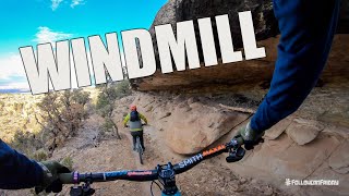
- Windmill (4.4/5)
- RAMPAGE (4.1/5)
- Snake Skin (4.1/5)
- Second Thoughts (4.1/5)
- Billings Canyon Jeep Trail (4/5)
▼
What is the best time of the year to ride in Third Flats?
Based on ride log data, the most popular months to ride in Third Flats are:
- April (23 activities)
- May (17 activities)
- October (17 activities)
▼
Where can I park to ride in Third Flats?
There are 8 parking locations listed in Third Flats. The most popular parking spots are: View all parking and trailhead locations on the map to plan your visit.
▼
What is the longest trail in Third Flats?
The longest trail in Third Flats is Windmill at 7.8 miles. View all trails sorted by distance.
Activities
Trails
Points of Interest
- By todd
 Trailforks & contributors
 - Admins: COPMOBA-GVT, COPMOBA-GVT
- #4883 - 12,336 views
- third flats activity log | embed map of Third Flats mountain bike trails | third flats mountain biking points of interest
Downloading of trail gps tracks in kml & gpx formats is enabled for Third Flats.
You must login to download files.