more stats
449 ft
Distance
-90 ft
Descent
00:03:54
Avg time
-91 ft
Altitude change
77 ft
Altitude min
171 ft
Altitude max
168 ft
Altitude start
79 ft
Altitude end
-20.3%
Grade
-63.2%
Grade max
13 ft
Distance climb
341 ft
Distance down
95 ft
Distance flat
00:03:54
Avg time

Elastomania Details

  • Activities
    • Mountain Bike
  • Riding Area
    Puszcza Bukowa
    Szczecin
  • AKA
    Mandat Wariat
  • Difficulty Rating
  • Local Popularity
    20 in Mountain Biking
  • Global Ranking
    #123520 in Mountain Biking
  • Trail Type
    Wilderness Trail
  • Bike Type
    DH, AM
  • Direction
    Downhill Only
    Popular Direction Shown
  • Physical Rating
    Hard
  • Trail Visibility
    Sometimes hard to follow
  • TTFs on Trail
    Berm, Drop, Jump, Other
  • Year Opened
    2020

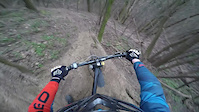
Zjazd jest wariantem przedłużającym trasę Mandat. Zaczyna się bardzo stromą ścianką, następnie przechodzi w wąski i techniczny trawers z agrafką w lewo. Przed nami kolejny wąski trawers, hopa, za którą trzeba złożyć się w prawy zakręt o 120 stopni, kolejne strome miejsce, kilka zakrętów i hopo - drop z kamieni. Potem już tylko końcówka - dojazdówka.

Wersja testowa

This trail is unsanctioned.

Recent Activity on Trail

Past Week
  • 0 rides
  •  
6 Months
  • 0 rides
  •  
All
  • 2 rides
  • Last: Apr 11, 2026
c1c2c3c4
January
February
March
April
May
June
July
August
September
October
November
December
update trails status or condition

Elastomania Trail Reports

statusdatedescription
Jan 6, 2024 @ 2:42am
Jan 6, 2024
reporter
Jan 6, 2022 @ 12:37am
Jan 6, 2022
reporter
Dec 10, 2021 @ 8:01am
Dec 10, 2021
reporter
Feb 21, 2021 @ 4:17am
Feb 21, 2021
reporter Środek trasy wymaga naprawy, uszkodzony profil z belką na kamienie
Jan 18, 2021 @ 11:45am
Jan 18, 2021
reporter
more »
Status:
on Jan 6, 2024
Snow Covered
Avg: 4.39 (4 votes)
Your vote: 0

view (59)
close
3D
Trail Conditions
  • Unknown
  • Snow Groomed
  • Snow Packed
  • Snow Covered
  • Snow Cover Partial
  • Freeze/thaw Cycle
  • Icy
  • Prevalent Mud
  • Wet
  • Variable
  • Ideal
  • Dry
  • Very Dry
Trail Flow (Ridden Direction)
Trailforks scans users ridelogs to determine the most popular direction each trail is ridden. A good flowing trail network will have most trails flowing in a single direction according to their intension.
The colour categories are based on what percentage of riders are riding a trail in its intended direction.
  • > 96%
  • > 90%
  • > 80%
  • > 70%
  • > 50%
  • < 50%
  • bi-directional trail
  • no data
Trail Last Ridden
Trailforks scans ridelogs to determine the last time a trail was ridden.
  • < 2 days
  • < 1 week
  • < 2 weeks
  • < 1 month
  • < 6 months
  • > 6 months
Trail Ridden Direction
The intended direction a trail should be ridden.
  • Downhill Only
  • Downhill Primary
  • Both Directions
  • Uphill Primary
  • Uphill Only
  • One Direction
Contribute Details
Colors indicate trail is missing specified detail.
  • Description
  • Photos
  • Description & Photos
  • Videos
Trail Popularity ?
Trailforks scans ridelogs to determine which trails are ridden the most in the last 9 months. Trails are compared with nearby trails in the same city region with a possible 25 colour shades. Think of this as a heatmap, more rides = more kinetic energy = warmer colors.
  • most popular
  • popular
  • less popular
  • not popular
ATV/ORV/OHV Filter
Max Vehicle Width
inches
US Cell Coverage
Legend
cell carrier legend

Radar Time
Activity Recordings
Trailforks uses anonymized public activity data. ?
Activity Recordings
Trailforks uses anonymized public activity data. ?
Personal Heatmap
Activity Types
all / none
Options
2
Date range month
Winter Trails
Warning A routing network for winter maps does not exist. Selecting trails using the winter trails layer has been disabled.
Missing Trails
Most Popular
Least Popular
Trails are colored based on popularity. The more popular a trail is, the more red. Less popular trails trend towards green.
Jump Magnitude Heatmap
Heatmap of where riders jump on trails. Zoom in to see individual jumps, click circles to view jump details.
BC Backroad Status

Service Road Atlas is a free to use, community-driven service for viewing and creating reports on the numerous back-country service roads around B.C. and Alberta.

map legend
Slope Aspect
Direction the slope faces
Flat N NE E SE S SW W NW
Trails Deemphasized
Trails are shown in grey.
disable
Only show trails with no bike usage.
Enable
Suggested Layers
Based on selected activity type

    Save the current map location and zoom level as your default home location whenever this page is loaded.

    Save
        Directions to elastomania trailhead (53.371320, 14.618770)

        Photos

        2 more »
        324 |
        Feb 16, 2020 @ 10:48am
        Feb 16, 2020
        385 |
        Feb 16, 2020 @ 10:45am
        Feb 16, 2020

        Videos

        1 more »
        Elastomania
        3:35 | 488 | Feb 22, 2020 , Szczecin

        1 Review & Comments


        We hope you've been enjoying Trailforks!

        Create a FREE account to view trail comments and much more.

        • #252916 - 1,737 views

        Frequently Asked Questions About Elastomania

        Where is Elastomania located?
        Elastomania is located in Puszcza Bukowa, Szczecin, Poland. It is part of the Puszcza Bukowa trail network. The trailhead is located at coordinates 53.37132, 14.61877.
        How hard is Elastomania?
        Elastomania is rated as Black difficulty. The physical rating is Hard. The average grade is 20.3%.
        What is the elevation gain for Elastomania?
        The trail has 90 ft of elevation descent. The elevation ranges from 77 ft to 171 ft.
        Is Elastomania a point to point trail?
        Yes, Elastomania is a point to point trail. The direction is Downhill Only. The trail type is wilderness trail.

        Hit the Trail

        Open in App

        Get this trail on your phone instantly.
        open trail in app

        Download Trail

        Save to wishlist, Garmin & download.
        save the trail

        Find Related Routes

        Find routes and users activities that include this trail.
        find routes for this trail

        You must enter a description before submitting.