more stats
3,625 ft
Distance
7 ft
Climb
-298 ft
Descent
00:04:39
Avg time
-292 ft
Altitude change
913 ft
Altitude min
1,205 ft
Altitude max
1,205 ft
Altitude start
912 ft
Altitude end
-8.1%
Grade
-28.8%
Grade max
11.1%
Grade min
226 ft
Distance climb
2,552 ft
Distance down
823 ft
Distance flat
00:04:39
Avg time

War Eagle Details

  • Activities
    • Mountain Bike
    • Winter Fat Bike
    • Hike
    • Trail Running
    • Snowshoe
  • Riding Area
    Gateway Trails
    La Crosse, Wisconsin
  • Difficulty Rating
  • Local Popularity
    60 in Mountain Biking [+]
    • 60 in Trail Running
    • 100 in Hiking
    • 5 in Snowshoeing
  • Global Ranking
    #86343 in Mountain Biking [+]
    • #41138 in Trail Running
    • #26001 in Hiking
  • Trail Type
    Singletrack
  • Bike Type
    AM, XC, Fat
  • Direction
    Downhill Primary
    Popular Direction Shown
  • Climb Difficulty
    Black Diamond
  • Physical Rating
    Hard
  • Trail Visibility
    Always easy to follow
  • Dogs Allowed
    Yes
  • TTFs on Trail
    Berm, Drop, Rock Face, Rock Garden
  • Year Opened
    2020
  • Land Owner
    Outdoor Recreation Alliance "ORA Trails"

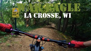
New in fall of 2020, part of the Grandad Bluff Trails as a partnership with City of La Crosse / Outdoor Recreation Alliance / IMBA Trail Solutions / VeloCity Projects. Built By Rock Solid Trail Contractors. This trail has tight corners, with one rock roll into a corner, a couple smaller rock drops, and some small rock gardens. This is a good example new school singletrack with an old school feel. Preferred direction of Travel is Downhill, but some people have tested their technical climbing abilities on this trail. Please watch for hikers as this is a shared use system.

Trail Supporters
Local Trail Association

Recent Activity on Trail

Past Week
  • 2 rides
  • 13 miles average
6 Months
  • 30 rides
  • 10 miles avg distance
All
  • 258 rides
  • Last: Jun 5, 2026
c1c2c3c4
January
February
March
April
May
June
July
August
September
October
November
December
update trails status or condition

War Eagle Trail Reports

statusdatedescription
Mar 25, 2026 @ 7:21am (America/Chicago)
Mar 25, 2026
Oct 27, 2024 @ 9:14am
Oct 27, 2024
Loose leaves make braking a challenge in some steep sections
Nov 18, 2023 @ 9:19am
Nov 18, 2023
Tree down
Nov 22, 2022 @ 1:06pm
Nov 22, 2022
reporter Freeze / Thaw cycles, melting snow and muddy conditions expected until real winter arrives
Jul 22, 2022 @ 8:29pm
Jul 22, 2022
Broken glass at entrance between first two entry rock gardens.
more »
Status:
on Mar 25, 2026
Ideal
Avg: 4.32 (4 votes)
Your vote: 0

view (2,116)
close
3D
Trail Conditions
  • Unknown
  • Snow Groomed
  • Snow Packed
  • Snow Covered
  • Snow Cover Partial
  • Freeze/thaw Cycle
  • Icy
  • Prevalent Mud
  • Wet
  • Variable
  • Ideal
  • Dry
  • Very Dry
Trail Flow (Ridden Direction)
Trailforks scans users ridelogs to determine the most popular direction each trail is ridden. A good flowing trail network will have most trails flowing in a single direction according to their intension.
The colour categories are based on what percentage of riders are riding a trail in its intended direction.
  • > 96%
  • > 90%
  • > 80%
  • > 70%
  • > 50%
  • < 50%
  • bi-directional trail
  • no data
Trail Last Ridden
Trailforks scans ridelogs to determine the last time a trail was ridden.
  • < 2 days
  • < 1 week
  • < 2 weeks
  • < 1 month
  • < 6 months
  • > 6 months
Trail Ridden Direction
The intended direction a trail should be ridden.
  • Downhill Only
  • Downhill Primary
  • Both Directions
  • Uphill Primary
  • Uphill Only
  • One Direction
Contribute Details
Colors indicate trail is missing specified detail.
  • Description
  • Photos
  • Description & Photos
  • Videos
Trail Popularity ?
Trailforks scans ridelogs to determine which trails are ridden the most in the last 9 months. Trails are compared with nearby trails in the same city region with a possible 25 colour shades. Think of this as a heatmap, more rides = more kinetic energy = warmer colors.
  • most popular
  • popular
  • less popular
  • not popular
ATV/ORV/OHV Filter
Max Vehicle Width
inches
US Cell Coverage
Legend
cell carrier legend

Radar Time
Activity Recordings
Trailforks uses anonymized public activity data. ?
Activity Recordings
Trailforks uses anonymized public activity data. ?
Personal Heatmap
Activity Types
all / none
Options
2
Date range month
Winter Trails
Warning A routing network for winter maps does not exist. Selecting trails using the winter trails layer has been disabled.
Missing Trails
Most Popular
Least Popular
Trails are colored based on popularity. The more popular a trail is, the more red. Less popular trails trend towards green.
Jump Magnitude Heatmap
Heatmap of where riders jump on trails. Zoom in to see individual jumps, click circles to view jump details.
BC Backroad Status

Service Road Atlas is a free to use, community-driven service for viewing and creating reports on the numerous back-country service roads around B.C. and Alberta.

map legend
Slope Aspect
Direction the slope faces
Flat N NE E SE S SW W NW
Trails Deemphasized
Trails are shown in grey.
disable
Only show trails with no bike usage.
Enable
Suggested Layers
Based on selected activity type

    Save the current map location and zoom level as your default home location whenever this page is loaded.

    Save
        Directions to war-eagle trailhead (43.811630, -91.205340)

        Photos

        13 more »
        601 |
        Dec 16, 2020 @ 3:06pm
        Dec 16, 2020
        315 |
        Oct 5, 2020 @ 6:43am
        Oct 5, 2020
        280 |
        Oct 5, 2020 @ 6:43am
        Oct 5, 2020
        279 |
        Oct 5, 2020 @ 6:36am
        Oct 5, 2020

        Videos

        4 more »
        Bottoming Out on War Eagle! - Grandad Bluff...
        10:08 | 237 | Mar 23, 2024 , La Crosse
        War Eagle Mountain Bike Trail, La Crosse, WI
        5:37 | 382 | Apr 30, 2023 , La Crosse
        Upper Hixon Forest Mountain Biking - War Eagle
        3:45 | 431 | Sep 25, 2021 , La Crosse
        War Eagle, La Crosse, WI
        275 | Sep 23, 2021 , La Crosse

        1 Review & Comments


        We hope you've been enjoying Trailforks!

        Create a FREE account to view trail comments and much more.

        • By blum585TF Pro & contributors
        • #327325 - 3,050 views

        Frequently Asked Questions About War Eagle

        Where is War Eagle located?
        War Eagle is located in Gateway Trails, La Crosse, Wisconsin, United States. It is part of the Gateway Trails trail network. The trailhead is located at coordinates 43.81163, -91.20534.
        How hard is War Eagle?
        War Eagle is rated as Black Diamond difficulty. The physical rating is Hard. The average grade is 8.1%. The climb difficulty is rated Black Diamond.
        What is the elevation gain for War Eagle?
        War Eagle has 7 ft of elevation gain. The trail has 298 ft of elevation descent. The elevation ranges from 913 ft to 1,205 ft.
        Is War Eagle a point to point trail?
        War Eagle is not a point to point trail. The direction is Downhill Primary. The trail type is singletrack.

        Hit the Trail

        Open in App

        Get this trail on your phone instantly.
        open trail in app

        Download Trail

        Save to wishlist, Garmin & download.
        save the trail

        Find Related Routes

        Find routes and users activities that include this trail.
        find routes for this trail

        You must enter a description before submitting.