
| Type: |  Lodge Lodge |
| Activities: |
|
-
7,994Checkins
-
7,761MTB
-
186Hike
-
0Moto
-
0Ski
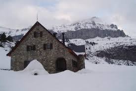
Situado al final del valle de Aragües del Puerto, justo pegado al valle de Hecho, en el llano de Lizara.
PLAZAS
75.
SERVICIOS
Agua potable, duchas e inodoros, agua caliente sanitaria, bar, servicio de comidas, mantas, botiquín y enfermería, aula polivalente, taquillas, guardaesquíes, calzado de descanso, teléfono, radiosocorro.
GUARDADO
Todo el año.
TITULAR
Mancomunidad Forestal de Aragüés del Puerto y Jasa
GESTIÓN
Federación Aragonesa de Montañismo (F.A.M.)
COMO LLEGAR
En coche hasta el mismo refugio por pista asfaltada desde la localidad de Aragüés del Puerto.
RESERVAS
Refugio de Lizara
22730 – Aragüés del Puerto (Huesca)
Tel. 974 34 84 33
[email protected]
Reservas on-line: https://www.alberguesyrefugios.com/lizara/reservar
Más info: https://www.alberguesyrefugios.com/lizara/
ACTIVIDADES
Travesías-senderismo: Lizara-Gabardito GR11.1, Lizara-Estanés-Candanchú, Lizara-Llano de los Sarrios-Foya de Aragüés-Bozo,...
Ascensiones: Bisaurín, Peña Mediodía, Aspe, Aguerri, Llena del Bozo, Llena de la Garganta,...
Otras actividades:escalada, cascadas de hielo, barrancos, esquí de montaña, espeleología.
Info por fam.es, más refugios libres en https://fam.es/refugios/listado-de-refugios.
PLAZAS
75.
SERVICIOS
Agua potable, duchas e inodoros, agua caliente sanitaria, bar, servicio de comidas, mantas, botiquín y enfermería, aula polivalente, taquillas, guardaesquíes, calzado de descanso, teléfono, radiosocorro.
GUARDADO
Todo el año.
TITULAR
Mancomunidad Forestal de Aragüés del Puerto y Jasa
GESTIÓN
Federación Aragonesa de Montañismo (F.A.M.)
COMO LLEGAR
En coche hasta el mismo refugio por pista asfaltada desde la localidad de Aragüés del Puerto.
RESERVAS
Refugio de Lizara
22730 – Aragüés del Puerto (Huesca)
Tel. 974 34 84 33
[email protected]
Reservas on-line: https://www.alberguesyrefugios.com/lizara/reservar
Más info: https://www.alberguesyrefugios.com/lizara/
ACTIVIDADES
Travesías-senderismo: Lizara-Gabardito GR11.1, Lizara-Estanés-Candanchú, Lizara-Llano de los Sarrios-Foya de Aragüés-Bozo,...
Ascensiones: Bisaurín, Peña Mediodía, Aspe, Aguerri, Llena del Bozo, Llena de la Garganta,...
Otras actividades:escalada, cascadas de hielo, barrancos, esquí de montaña, espeleología.
Info por fam.es, más refugios libres en https://fam.es/refugios/listado-de-refugios.
close
3D
Trail Conditions
- Unknown
- Snow Groomed
- Snow Packed
- Snow Covered
- Snow Cover Partial
- Freeze/thaw Cycle
- Icy
- Prevalent Mud
- Wet
- Variable
- Ideal
- Dry
- Very Dry
Trail Flow (Ridden Direction)
Trailforks scans users activity logs to determine the most popular direction each trail is ridden. A good flowing trail network will have most trails flowing in a single direction according to their intension.
The colour categories are based on what percentage of users are riding a trail in its intended direction.
The colour categories are based on what percentage of users are riding a trail in its intended direction.
- > 96%
- > 90%
- > 80%
- > 70%
- > 50%
- < 50%
- bi-directional trail
- no data
Trail Last Used
Trailforks scans activity logs to determine the last time a trail was ridden.
- < 2 days
- < 1 week
- < 2 weeks
- < 1 month
- < 6 months
- > 6 months
Trail Ridden Direction
The intended direction a trail should be ridden.
- Downhill Only
- Downhill Primary
- Both Directions
- Uphill Primary
- Uphill Only
- One Direction
Contribute Details
Colors indicate trail is missing specified detail.
- Description
- Photos
- Description & Photos
- Videos
Trail Popularity ?
Trailforks scans activity logs to determine which trails are ridden the most in the last 9 months.
Trails are compared with nearby trails in the same city region with a possible 25 colour shades.
Think of this as a heatmap, more activities = more kinetic energy = warmer colors.
- most popular
- popular
- less popular
- not popular
ATV/ORV/OHV Filter
Max Vehicle Width
inches
US Cell Coverage
Legend

Radar Time
Activity Recordings
Trailforks uses anonymized public activity data.
?
Activity Recordings
Trailforks uses anonymized public activity data.
?
Winter Trails
Warning
A routing network for winter maps does not exist. Selecting trails using the winter trails layer has been disabled.
Missing Trails
Most Popular
Least Popular
Trails are colored based on popularity. The more popular a trail is, the more red. Less popular trails trend towards green.
Jump Magnitude Heatmap
Heatmap of where users jump on trails. Zoom in to see individual jumps, click circles to view jump details.
BC Backroad Status
![map legend]()
Service Road Atlas is a free to use, community-driven service for viewing and creating reports on the numerous back-country service roads around B.C. and Alberta.

Slope Aspect
Direction the slope faces
Trails Deemphasized
Trails are shown in grey.
Only show trails with no bike usage.
Suggested Layers
Based on selected activity type
Save the current map location and zoom level as your default home location whenever this page is loaded.
SaveAttached Trail
| trail name | difficulty | riding area |
|---|---|---|
| Ref. Lizara-Collado del Bozo | Lizara |
Comments
We hope you've been enjoying Trailforks!
Create a FREE account to view POI comments and much more.
Other Points of Interest in Lizara
- Refugio de Fetás Cabin
- Refugio de Vernera Cabin
- Refugio del Foraton Cabin
- [ref. ng} de Plan d\'Aniz (Dios te salve) Cabin
- By pcorreas
 TFSPAIN
- #102444