
more stats
1.9 miles
Distance
85 ft
Climb
-1,794 ft
Descent
00:34:36
Avg time
-1,709 ft
Altitude change
1,715 ft
Altitude min
3,428 ft
Altitude max
3,428 ft
Altitude start
1,719 ft
Altitude end
-17.4%
Grade
-83.9%
Grade max
25.1%
Grade min
1,516 ft
Distance climb
1 mile
Distance down
640 ft
Distance flat
00:34:36
Avg time

Cacciatori Details

  • Activities
    • Mountain Bike
    • E-Bike
    • Hike
    • Trail Running
  • Riding Area
  • Difficulty Rating
  • Voted Difficulty
    Blue (3 votes)
  • Local Popularity
    20 in Mountain Biking [+]
    • 25 in E-Biking
    • 5 in Trail Running
    • 5 in Hiking
  • Global Ranking
    #133454 in Mountain Biking [+]
    • #102916 in E-Biking
    • #215933 in Trail Running
    • #207098 in Hiking
  • National Ranking
    #10,129 in Mountain Biking · Italy [+]
    • #11,014 in E-Biking
    • #6,217 in Trail Running
    • #6,012 in Hiking
  • Trail Type
    Singletrack
  • Bike Type
    DH, AM, XC
  • Direction
    Downhill Only
    Popular Direction Shown
  • Alpine Trail
    Yes
  • Dogs Allowed
    Yes
  • eBike Allowed
    Yes up to Class 1

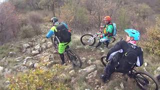
Sentiero flow e ripido.
L'inizio non è facilissimo da individuare e seguire: fare riferimento alla traccia.

Tags
Alpine

Recent Activity on Trail

Past Week
  • 0 rides
  •  
6 Months
  • 0 rides
  •  
All
  • 7 rides
  • Last: Feb 15, 2026
c1c2c3c4
January
February
March
April
May
June
July
August
September
October
November
December
update trails status or condition

Cacciatori Trail Reports

statusdatedescription
Aug 6, 2026 @ 12:15am (Europe/Rome)
Aug 5, 2026
La traccia è in buone condizioni nel complesso. Prato iniziale OK. Traverso nel bosco è stato pulito ma alcuni tratti restano difficili da...
Jun 7, 2026 @ 10:31pm (Europe/Rome)
Jun 7, 2026
Un po’ scavato in alcuni punti, un po di materiale di riporto accumulato qua e la, dopo le piogge dei giorni scorsi oggi l’aderenza era buona
Feb 8, 2026 @ 6:42pm (Europe/Rome)
Feb 8, 2026
reporter riconfermo i report precedenti, i ripidi stanno diventando difficili da raidare
Oct 3, 2025 @ 9:58am (Europe/Rome)
Oct 3, 2025
La traccia sta scomparendo per erosione in atto sulle parti ripide in alto.. ( dopo il traverso) .. ad ogni modo sempre divertente!!
Sep 20, 2024 @ 12:59pm
Sep 20, 2024
reporter Traverso iniziale da evitare, parte centrale ok, mentre dal ripido centrale il sentiero inizia ad avere problemi di erosione
more »
Status:
on Aug 6, 2026
Very Dry
Avg: 3.76 (4 votes)
Your vote: 0

view (52)
close
      Directions to cacciatori-113498 trailhead (45.833380, 9.302060)

      Photos

      9 more »
      mtb
      68 |
      Jul 12, 2022 @ 4:03pm
      Jul 12, 2022
      mtb
      60 |
      Jul 12, 2022 @ 4:03pm
      Jul 12, 2022
      mtb
      62 |
      Jul 12, 2022 @ 4:03pm
      Jul 12, 2022
      mtb
      94 |
      Jul 12, 2022 @ 4:03pm
      Jul 12, 2022

      Videos

      1 more »
      Cornizzolo 'sentiero cacciatori' (Lc) 13/11/2016
      mtb
      11:41 | 595 | Feb 24, 2022 , Civate
      3.5 ★★★★★
      4 Ratings
      5 ★
      4 ★ 50%
      3 ★ 50%
      2 ★
      1 ★

      3 Reviews & Comments

      Guret Guret
      Consigliato prendere il trail dalla cresta erbosa prima di quella segnata sulla traccia per evitare il traverso in falsopiano, spesso molto sporco
      Velofahrer
      It's definitely not green. Should be blue. There are also some steep sections. But it's a nice trail.

      We hope you've been enjoying Trailforks!

      Create a FREE account to view all trail reviews and much more.

      • By barc74 & contributors
      • #113498 - 3,704 views

      Frequently Asked Questions

      ▼ Where is Cacciatori located?
      Cacciatori is located in Monte Cornizzolo, Civate, Italy. It is part of the Monte Cornizzolo trail network. The trailhead is located at coordinates 45.83338, 9.30206.
      ▼ How hard is Cacciatori?
      Cacciatori is rated as Black difficulty. The average grade is 17.4%.
      ▼ What is the elevation gain for Cacciatori?
      Cacciatori has 85 ft of elevation gain. The trail has 1,794 ft of elevation descent. The elevation ranges from 1,715 ft to 3,428 ft.
      ▼ Is Cacciatori a point to point trail?
      Yes, Cacciatori is a point to point trail. The direction is Downhill Only. The trail type is singletrack.
      ▼ How long is Cacciatori?
      Cacciatori is 1.9 miles long. The trail type is singletrack.
      ▼ Are dogs allowed on Cacciatori?
      Yes, dogs are allowed on Cacciatori. Please keep dogs on a leash where required and clean up after them.
      ▼ How do I access Cacciatori? Where is the closest parking trailhead?
      The closest parking and trailhead locations to Cacciatori are: View all parking locations in the area.
      ▼ How long does it take to ride Cacciatori?
      Based on recorded activities, it takes an average of 35 minutes to ride Cacciatori. The trail is 1.9 miles long. Actual times will vary based on fitness level, conditions, and pace. View recent activity logs for more details.
      ▼ How busy is Cacciatori?
      Cacciatori is a less popular trail with lighter traffic. There have been 50 recorded activities on this trail. The trail has received 52 check-ins. View recent activity on this trail.

      Hit the Trail

      Open in App

      Get this trail on your phone instantly.

      open trail in app

      Download Trail

      Save to wishlist, Garmin & download.
      save the trail

      Find Related Routes

      Find routes and users activities that include this trail.
      find routes for this trail

      You must enter a description before submitting.

