-
DateSunday March 12, 2017 at
8:00am to 11:00am AEST
past event -
TypeRaceXC
-
ActivitiesMountain Bike
-
Location
-
Route
-
Facebook
-
RegistrationOpen Paid
-
Organizer
What – Round 1 CQ Cross Country Series 2017
When – Sunday 12th March 2017
Where – Gladstone Mountain Bike Reserve, Koowin Drive Kirkwood.
How - https://online.mtba.asn.au/ERegister.aspx?E=3594
Race start time – 8.00am
Race number allocation – 7.00am – 7.45am
Riders Briefing 7.50am
On Line Entry Cost – $25 Snr (Elite, Masters, Sport, Female, Novice), $10 Junior
On line entries only - on the day not available.
MTBA competition licence required or Day Licence available for additional $25 (purchase on line during your entry) for non MTBA members ages 19+, $15 for non-members 19 years; $15 for a MTBA recreation member upgrade.
Close of On Line Entries - 8.00pm Saturday 11th March
Lap numbers and lap distance
• Elite – 4 laps x 8.3 km, about 33 km
• Masters (40 yrs and over) - 3 laps x 8.3 km about 25 km
• Sport – 3 laps x 8.3 km, about 25 km
• Ladies - 4 laps x 3.3 km, about 13 km (easier course)
• Novice – 4 laps x 3.3 km, about 13 km (easier course)
• Junior (Under 15 as of 31 Dec 17) – 3 laps x 3.3 km about 10 km (easier course)
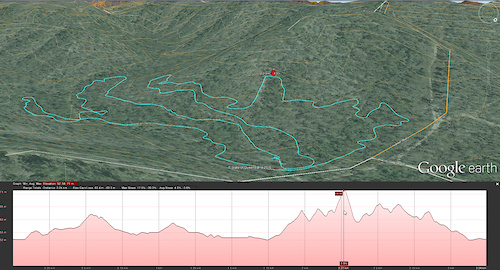
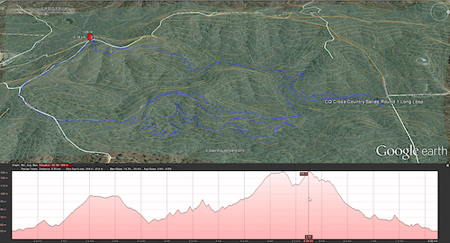
Long Loop – Start at Presentation Area, up Valley fire trail, left into Carthubie Crawl, right onto EZ Up, along fire trail then left down Joker, sharp right up Gambler, left onto fire trail up Stairway to Hell, around ridgeline right onto Griller, down Rusty Barrow, Wild West, Valley Maze over The Rock, left onto Valley fire trail, out gate onto Creek 3, Lo Flo, Stump Link right onto Valley fire trail past timing tent. 8.3km.
https://ridewithgps.com/trips/13004090
Short Loop (easier course) - Start at Presentation Area, up Valley fire trail, left into Creek 2, right through creek crossing along EZ Lower left onto Gambler Lower through creek right onto Creek 1, Stump Link straight onto TWiNN (short version), Stump Link right onto Valley fire trail past timing tent. 3.3km
https://ridewithgps.com/trips/13002982
Sausage sizzle and drinks available for purchase.
This is Round 1 of a 5 Round Central Queensland XC series (Rockhampton and Gladstone MTB). Series points will be awarded for all places, series winners will be decided from the best 4 placings across the 5 rounds. Rocky & Gladstone MTB Club members who chose to work a round will receive average points for that round (limited to one round only).
No cash or sponsors prizes will be awarded for podium finishers, all entry fees will go towards building new club trails this year. A random draw may be held after the race if there are sufficient sponsors prizes.
Check Rocky or Gladstone MTB Facebook pages for race cancellations (only likely in the event of heavy overnight rain). It is a requirement that you remove your own rubbish from the site. No camping permitted for this event.
Comments
-
- Signup Link
- Download
- Subscribe
-
18interested
-
27going
Event Photos
Route
-
2017 CQ Cross Country Series Round 1 Long Loop
close-
Layers w
- Weather Layers
- Pro
- Pro
- Pro
- Pro
- Pro
- Pro
- More Layers
- Pro
- Pro
- Pro
- Pro
-
Upgrade to

3DTrail Conditions- Unknown
- Snow Groomed
- Snow Packed
- Snow Covered
- Snow Cover Partial
- Freeze/thaw Cycle
- Icy
- Prevalent Mud
- Wet
- Variable
- Ideal
- Dry
- Very Dry
Trail Flow (Ridden Direction)Trailforks scans users ridelogs to determine the most popular direction each trail is ridden. A good flowing trail network will have most trails flowing in a single direction according to their intension.
The colour categories are based on what percentage of riders are riding a trail in its intended direction.- > 96%
- > 90%
- > 80%
- > 70%
- > 50%
- < 50%
- bi-directional trail
- no data
Trail Last RiddenTrailforks scans ridelogs to determine the last time a trail was ridden.- < 2 days
- < 1 week
- < 2 weeks
- < 1 month
- < 6 months
- > 6 months
Trail Ridden DirectionThe intended direction a trail should be ridden.- Downhill Only
- Downhill Primary
- Both Directions
- Uphill Primary
- Uphill Only
- One Direction
Contribute DetailsColors indicate trail is missing specified detail.- Description
- Photos
- Description & Photos
- Videos
Trail Popularity ?Trailforks scans ridelogs to determine which trails are ridden the most in the last 9 months. Trails are compared with nearby trails in the same city region with a possible 25 colour shades. Think of this as a heatmap, more rides = more kinetic energy = warmer colors.- most popular
- popular
- less popular
- not popular
ATV/ORV/OHV FilterMax Vehicle WidthinchesUS Cell CoverageLegend
Radar TimeActivity RecordingsTrailforks uses anonymized public activity data. ?Activity RecordingsTrailforks uses anonymized public activity data. ?Personal Heatmap▶ Activity Typesall / none▶ Options2Date range month–Winter TrailsWarning A routing network for winter maps does not exist. Selecting trails using the winter trails layer has been disabled.Missing TrailsMost PopularLeast PopularTrails are colored based on popularity. The more popular a trail is, the more red. Less popular trails trend towards green.Jump Magnitude HeatmapHeatmap of where riders jump on trails. Zoom in to see individual jumps, click circles to view jump details.BC Backroad Status
Service Road Atlas is a free to use, community-driven service for viewing and creating reports on the numerous back-country service roads around B.C. and Alberta.
![map legend]() Slope AspectDirection the slope facesTrails DeemphasizedTrails are shown in grey.Only show trails with no bike usage.Suggested LayersBased on selected activity type
Slope AspectDirection the slope facesTrails DeemphasizedTrails are shown in grey.Only show trails with no bike usage.Suggested LayersBased on selected activity typeSave the current map location and zoom level as your default home location whenever this page is loaded.
SaveTrail transparency- Singletrack
- Unpaved
5.1 milesDistance660 ftClimb-665 ftDescent454 ftHigh Point-2 ftAltitude change165 ftAltitude min171 ftAltitude start167 ftAltitude end-31%Grade max23.6%Grade min2 milesDistance climb2 milesDistance down3,081 ftDistance flat -
