-
DateFriday April 1, 2022 at 6:30am +03toFriday April 1, 2022 at 10:30am
past event -
TypeTrail DayXC
-
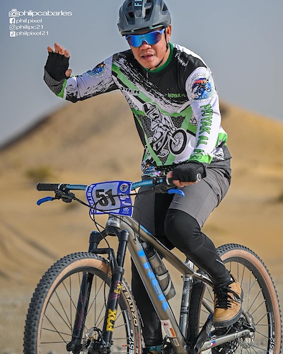
ActivitiesMountain Bike
-
Location
-
Route
-
Trail
-
RegistrationInvite
-
Organizer
رابط خرائط جوجل
Location Pin on Google Maps
No one is allowed to participate without a bike, suitable clothing and a bike helmet.
لن يسمح بمشاركة من لا يمتلك دراجة جبلية مناسبة, وزي رياضي وخوذة ملائمة.
No vehicles are allowed to park inside the trails, ride/walk in to the registration booth
يمنع الوقوف داخل دروب الجبل, إتجه الى طاولة التسجيل مشياً أو بالدراجة
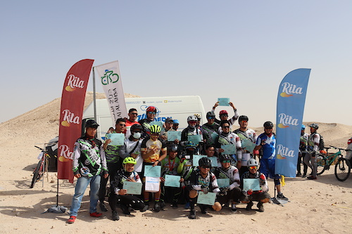
Padyak AlAhsa Cross-Country Mountain Biking Challenge is held on top of Al-Shu'ba Mountain.
Challenge Information :
Total Distance : 16.5km, three laps over 5.5km course.
Briefing : 5:30am
Start : 6:30am
Cut-off Time : 8:45am
Awarding Ceremony : 9:00am
تحدي بادياك الأحساء للدراجات الجبلية -اختراق الضاحية الهوائية في جبل الشعبة.
معلومات التحدي :
اجمالي المسافة 15.5كم ثلاث لفات
التجمع لإستلام أرقام السباق في الخامسة والنصف صباحاً
ينطلق السباق في الساعة السادسة والنصف صباحاً
آخر موعد الإنهاء السباق في الساعة الثامنة وخمسٌ وأربعون دقيقة صباحاً
نهاية السباق وبداية توزيع الجوائز الساعة التاسعة صباحاً
Comments
-
- Download
- Subscribe
-
0interested
-
1going
Event Photos
Route
-
Darraj AlAhsa XC Challenge Route (3 Laps)
close-
Layers w
- Weather Layers
- Pro
- Pro
- Pro
- Pro
- Pro
- Pro
- More Layers
- Pro
- Pro
- Pro
- Pro
-
Upgrade to

3DTrail Conditions- Unknown
- Snow Groomed
- Snow Packed
- Snow Covered
- Snow Cover Partial
- Freeze/thaw Cycle
- Icy
- Prevalent Mud
- Wet
- Variable
- Ideal
- Dry
- Very Dry
Trail Flow (Ridden Direction)Trailforks scans users ridelogs to determine the most popular direction each trail is ridden. A good flowing trail network will have most trails flowing in a single direction according to their intension.
The colour categories are based on what percentage of riders are riding a trail in its intended direction.- > 96%
- > 90%
- > 80%
- > 70%
- > 50%
- < 50%
- bi-directional trail
- no data
Trail Last RiddenTrailforks scans ridelogs to determine the last time a trail was ridden.- < 2 days
- < 1 week
- < 2 weeks
- < 1 month
- < 6 months
- > 6 months
Trail Ridden DirectionThe intended direction a trail should be ridden.- Downhill Only
- Downhill Primary
- Both Directions
- Uphill Primary
- Uphill Only
- One Direction
Contribute DetailsColors indicate trail is missing specified detail.- Description
- Photos
- Description & Photos
- Videos
Trail Popularity ?Trailforks scans ridelogs to determine which trails are ridden the most in the last 9 months. Trails are compared with nearby trails in the same city region with a possible 25 colour shades. Think of this as a heatmap, more rides = more kinetic energy = warmer colors.- most popular
- popular
- less popular
- not popular
ATV/ORV/OHV FilterMax Vehicle WidthinchesUS Cell CoverageLegend
Radar TimeActivity RecordingsTrailforks uses anonymized public activity data. ?Activity RecordingsTrailforks uses anonymized public activity data. ?Personal Heatmap▶ Activity Typesall / none▶ Options2Date range month–Winter TrailsWarning A routing network for winter maps does not exist. Selecting trails using the winter trails layer has been disabled.Missing TrailsMost PopularLeast PopularTrails are colored based on popularity. The more popular a trail is, the more red. Less popular trails trend towards green.Jump Magnitude HeatmapHeatmap of where riders jump on trails. Zoom in to see individual jumps, click circles to view jump details.BC Backroad Status
Service Road Atlas is a free to use, community-driven service for viewing and creating reports on the numerous back-country service roads around B.C. and Alberta.
![map legend]() Slope AspectDirection the slope facesTrails DeemphasizedTrails are shown in grey.Only show trails with no bike usage.Suggested LayersBased on selected activity type
Slope AspectDirection the slope facesTrails DeemphasizedTrails are shown in grey.Only show trails with no bike usage.Suggested LayersBased on selected activity typeSave the current map location and zoom level as your default home location whenever this page is loaded.
SaveTrail transparency- Unpaved
more stats10.3 milesDistance369 ftClimb-400 ftDescent685 ftHigh Point-29 ftAltitude change618 ftAltitude min649 ftAltitude start620 ftAltitude end-0.1%Grade-31.4%Grade max23.7%Grade min3 milesDistance climb3 milesDistance down3 milesDistance flat -
