-
DateSaturday October 15, 2022 at 8:30am CDT
past event -
TypeRaceXC Marathon
-
ActivitiesMountain Bike Hike
-
Location
-
Route
-
RegistrationOpen Paid
Race Details:
Reto teul mtb es un evento de ciclismo de montaña diseñado para intermedios avanzados por los senderos de la sierra del Teul, teniendo una ruta muy divertida. ven te esperamos tiene de todo, acenso, decenso trail, tecnico, rock garden, sendero rapido, en general muy completo el reto, se contara con premicacion en efectivo a los campeones y campeonas de la crono escalada
 nembien
Oct 12, 2022 at 20:40
nembien
Oct 12, 2022 at 20:40
-
- Download
- Subscribe
-
0interested
-
0going
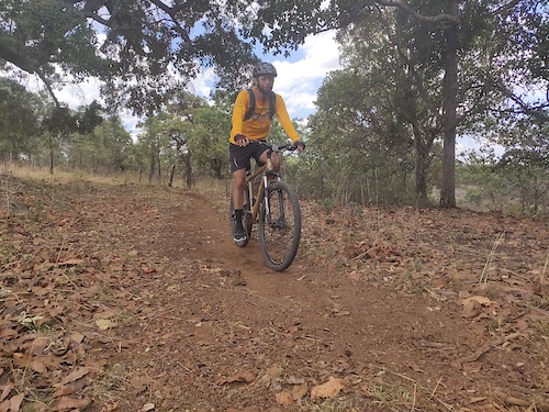
Event Photos

Route
-
RETO TEUL MTB
close-
Layers w
- Weather Layers
- Pro
- Pro
- Pro
- Pro
- Pro
- Pro
- More Layers
- Pro
- Pro
- Pro
- Pro
-
Upgrade to

3DTrail Conditions- Unknown
- Snow Groomed
- Snow Packed
- Snow Covered
- Snow Cover Partial
- Freeze/thaw Cycle
- Icy
- Prevalent Mud
- Wet
- Variable
- Ideal
- Dry
- Very Dry
Trail Flow (Ridden Direction)Trailforks scans users ridelogs to determine the most popular direction each trail is ridden. A good flowing trail network will have most trails flowing in a single direction according to their intension.
The colour categories are based on what percentage of riders are riding a trail in its intended direction.- > 96%
- > 90%
- > 80%
- > 70%
- > 50%
- < 50%
- bi-directional trail
- no data
Trail Last RiddenTrailforks scans ridelogs to determine the last time a trail was ridden.- < 2 days
- < 1 week
- < 2 weeks
- < 1 month
- < 6 months
- > 6 months
Trail Ridden DirectionThe intended direction a trail should be ridden.- Downhill Only
- Downhill Primary
- Both Directions
- Uphill Primary
- Uphill Only
- One Direction
Contribute DetailsColors indicate trail is missing specified detail.- Description
- Photos
- Description & Photos
- Videos
Trail Popularity ?Trailforks scans ridelogs to determine which trails are ridden the most in the last 9 months. Trails are compared with nearby trails in the same city region with a possible 25 colour shades. Think of this as a heatmap, more rides = more kinetic energy = warmer colors.- most popular
- popular
- less popular
- not popular
ATV/ORV/OHV FilterMax Vehicle WidthinchesUS Cell CoverageLegend
Radar TimeActivity RecordingsTrailforks uses anonymized public activity data. ?Activity RecordingsTrailforks uses anonymized public activity data. ?Personal Heatmap▶ Activity Typesall / none▶ Options2Date range month–Winter TrailsWarning A routing network for winter maps does not exist. Selecting trails using the winter trails layer has been disabled.Missing TrailsMost PopularLeast PopularTrails are colored based on popularity. The more popular a trail is, the more red. Less popular trails trend towards green.Jump Magnitude HeatmapHeatmap of where riders jump on trails. Zoom in to see individual jumps, click circles to view jump details.BC Backroad Status
Service Road Atlas is a free to use, community-driven service for viewing and creating reports on the numerous back-country service roads around B.C. and Alberta.
![map legend]() Slope AspectDirection the slope facesTrails DeemphasizedTrails are shown in grey.Only show trails with no bike usage.Suggested LayersBased on selected activity type
Slope AspectDirection the slope facesTrails DeemphasizedTrails are shown in grey.Only show trails with no bike usage.Suggested LayersBased on selected activity typeSave the current map location and zoom level as your default home location whenever this page is loaded.
SaveTrail transparency- Singletrack
- Unpaved
41.9 milesDistance3,857 ftClimb-3,987 ftDescent2 milesHigh Point-131 ftAltitude change6,037 ftAltitude min6,234 ftAltitude start6,102 ftAltitude end-0.1%Grade-32.3%Grade max83.5%Grade min20 milesDistance climb18 milesDistance down4 milesDistance flat -
