Sendas relativamente asequibles técnicamente, las que bajan al puente de Tagüenza tienen el inconveniente que hay que salir por donde se ha entrado o por la contaria, y la que da al lado de Huertahernando/Buenafuente está bastante inclinada y tocará empujar la bici bastante rato.
Incluidas las pistas de la zona entre el Puente de San Pedro y Zaorejas para todos los amantes del Gravel / Cicloturismo / Mtb "sencillo" por su alto valor paisajístico.
Incluidas las pistas de la zona entre el Puente de San Pedro y Zaorejas para todos los amantes del Gravel / Cicloturismo / Mtb "sencillo" por su alto valor paisajístico.
- Mountain Bike
Login to see your progress towards riding all the trails and routes in this list.
Trails
| title | riding area | rating | distance | completed | |||
|---|---|---|---|---|---|---|---|
| 1 | Barranco Del Ciño Negro - Zaorejas | 2 miles | |||||
| 2 | Casas del Salto | 3 miles | |||||
| 3 | Cauce del Tajo (Puente de San Pedro - Peñalén) | 9 miles | |||||
| 4 | De Olmeda Hacia Cuevas Labradas | 1 mile | |||||
| 5 | GR-10 - Puente de Tagüenza (Lado Buenafuente) | 1 mile | |||||
| 6 | GR-10 - Puente de Tagüenza (Lado Huertapelayo) | 1 mile | |||||
| 7 | GR-10 Buenafuente Del Sistal - Villar De Cobeta | 4,016 ft | |||||
| 8 | GR-10 Buenafuente Del Sistal - Villar De Cobeta | 1 mile | |||||
| 9 | La Cañada - Cuesta de la Cantera | 3,330 ft | |||||
| 10 | La Dehesa (Olmeda de Cobeta) | 1,926 ft | |||||
| 11 | Laguna De Taravilla - CM-210 | 4 miles | |||||
| 12 | Las Cabreras | 4,685 ft | |||||
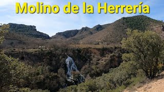
| 13 | Molino De La Herrería | 1 mile | |||||
| 14 | Olmeda de Cobeta | 3,520 ft | |||||
| 15 | Para de la Burra (Alto) | 3,022 ft | |||||
| 16 | Peña Moñúz | 1 mile | |||||
| 17 | Poyal del Tio Briones | 6 miles | |||||
| 18 | Puente del Salto de Poveda | 1,598 ft | |||||
| 19 | Puntal De Los Pradillos - Llano De Fuente Ana | 4,898 ft | |||||
| 20 | Salto de Póveda | 1,411 ft |
Displaying 20
Videos
2:36 |
166 |
Mar 21, 2023 , Molina De Aragón
Recent Trail Reports
| status | trail | date | condition | |
|---|---|---|---|---|
| Olmeda de Cobeta | May 31, 2025 @ 10:09am (Europe/Madrid) May 31, 2025 | view | ||
| GR-10 Buenafuente Del Sistal - Villar De Cobeta | May 31, 2025 @ 10:09am (Europe/Madrid) May 31, 2025 | view | ||
| La Dehesa (Olmeda de Cobeta) | May 31, 2025 @ 10:09am (Europe/Madrid) May 31, 2025 | view | ||
| Peña Moñúz | May 31, 2025 @ 10:09am (Europe/Madrid) May 31, 2025 | view | ||
| Para de la Burra (Alto) | May 31, 2025 @ 10:09am (Europe/Madrid) May 31, 2025 | view |
Total Trails
20
Total Distance
37 miles
Total Descent
-7,112 ft
Total Climb
4,625 ft
close
-
Layers w
- Weather Layers
- Pro
- Pro
- Pro
- Pro
- Pro
- Pro
- More Layers
- Pro
- Pro
- Pro
- Pro
-
Upgrade to

3D
Trail Conditions
- Unknown
- Snow Groomed
- Snow Packed
- Snow Covered
- Snow Cover Partial
- Freeze/thaw Cycle
- Icy
- Prevalent Mud
- Wet
- Variable
- Ideal
- Dry
- Very Dry
Trail Flow (Ridden Direction)
Trailforks scans users ridelogs to determine the most popular direction each trail is ridden. A good flowing trail network will have most trails flowing in a single direction according to their intension.
The colour categories are based on what percentage of riders are riding a trail in its intended direction.
The colour categories are based on what percentage of riders are riding a trail in its intended direction.
- > 96%
- > 90%
- > 80%
- > 70%
- > 50%
- < 50%
- bi-directional trail
- no data
Trail Last Ridden
Trailforks scans ridelogs to determine the last time a trail was ridden.
- < 2 days
- < 1 week
- < 2 weeks
- < 1 month
- < 6 months
- > 6 months
Trail Ridden Direction
The intended direction a trail should be ridden.
- Downhill Only
- Downhill Primary
- Both Directions
- Uphill Primary
- Uphill Only
- One Direction
Contribute Details
Colors indicate trail is missing specified detail.
- Description
- Photos
- Description & Photos
- Videos
Trail Popularity ?
Trailforks scans ridelogs to determine which trails are ridden the most in the last 9 months.
Trails are compared with nearby trails in the same city region with a possible 25 colour shades.
Think of this as a heatmap, more rides = more kinetic energy = warmer colors.
- most popular
- popular
- less popular
- not popular
ATV/ORV/OHV Filter
Max Vehicle Width
inches
US Cell Coverage
Legend

Radar Time
Activity Recordings
Trailforks uses anonymized public activity data.
?
Activity Recordings
Trailforks uses anonymized public activity data.
?
Personal Heatmap
▶
Activity Types
all
/
none
▶
Options
2
Date range
month
–
Winter Trails
Warning
A routing network for winter maps does not exist. Selecting trails using the winter trails layer has been disabled.
Missing Trails
Most Popular
Least Popular
Trails are colored based on popularity. The more popular a trail is, the more red. Less popular trails trend towards green.
Jump Magnitude Heatmap
Heatmap of where riders jump on trails. Zoom in to see individual jumps, click circles to view jump details.
BC Backroad Status
![map legend]()
Service Road Atlas is a free to use, community-driven service for viewing and creating reports on the numerous back-country service roads around B.C. and Alberta.

Slope Aspect
Direction the slope faces
Trails Deemphasized
Trails are shown in grey.
Only show trails with no bike usage.
Suggested Layers
Based on selected activity type
Save the current map location and zoom level as your default home location whenever this page is loaded.
Save
Trail transparency
Average difficulty
Trails and Routes in List - Distance by Difficulty
Trails and Routes in List - Difficulty Totals
- By Kalamarrrrrdo
 TFSPAIN
 - #1019 - 283 views