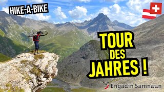
The bike tour in the «Three Countries Corner» leads along old trade routes, military roads and smugglers' trails through three language regions. Rugged valleys, enchanting mountain lakes and passes in three countries, lead from the Alpine duty-free municipality of Samnaun into southern Veltlin.
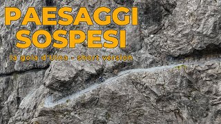
Starting point of this bike tour is at 1800 metres above sea level in the municipality of Samnaun in the eastern end of Switzerland. The first part of the tour is characterized by rugged high valleys on the Austrian-Swiss border. Highlights of the first stage are the Val Sinestra, voted Landscape of the Year in 2011 and the typical Engadin village of Sent. The route continues along historic border and smugglers' trails through the Val d'Uina with its spectacular cliff passage, leading first to Italy in the upper Vinschgau and back on to Swiss soil in the Val Müstair biosphere.
From Sta. Maria it leads over the Umbrailpass to Italy where the single trail to the Bocchetta di Forcola begins. In the rugged, high mountain landscape you encounter evidence of the First World War in the form of trenches, fortifications and the remains of dwellings. Here, one century ago, Swiss, Austrians and Italians faced each other without things ever escalating into war. The former military routes have been transformed into attractive bike routes. From Valle di Cancano to Arnoga evidence from a different era becomes visible: the production of electricity by hydropower.
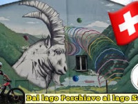
The ascent of the Italian Val Viola brings you to the border pass of Val Viola. On the other side are several mountain lakes of incomparable beauty. The route continues through the Val da Camp down into Val Poschiavo.
The last stage leads to San Romerio. The oldest part of its small church dates from the 11th century. The descent, then leads on gravel and asphalt roads to the Viano border village. After the border crossing you enter the vineyards above Tirano. The landscape and settlements leave no room for doubt that we have arrived on the southern side of the Alps.
Starting point of this bike tour is at 1800 metres above sea level in the municipality of Samnaun in the eastern end of Switzerland. The first part of the tour is characterized by rugged high valleys on the Austrian-Swiss border. Highlights of the first stage are the Val Sinestra, voted Landscape of the Year in 2011 and the typical Engadin village of Sent. The route continues along historic border and smugglers' trails through the Val d'Uina with its spectacular cliff passage, leading first to Italy in the upper Vinschgau and back on to Swiss soil in the Val Müstair biosphere.
From Sta. Maria it leads over the Umbrailpass to Italy where the single trail to the Bocchetta di Forcola begins. In the rugged, high mountain landscape you encounter evidence of the First World War in the form of trenches, fortifications and the remains of dwellings. Here, one century ago, Swiss, Austrians and Italians faced each other without things ever escalating into war. The former military routes have been transformed into attractive bike routes. From Valle di Cancano to Arnoga evidence from a different era becomes visible: the production of electricity by hydropower.
The ascent of the Italian Val Viola brings you to the border pass of Val Viola. On the other side are several mountain lakes of incomparable beauty. The route continues through the Val da Camp down into Val Poschiavo.
The last stage leads to San Romerio. The oldest part of its small church dates from the 11th century. The descent, then leads on gravel and asphalt roads to the Viano border village. After the border crossing you enter the vineyards above Tirano. The landscape and settlements leave no room for doubt that we have arrived on the southern side of the Alps.
- Mountain Bike
- E-Bike
Login to see your progress towards riding all the trails and routes in this list.
Trails
| title | riding area | rating | distance | completed | |||
|---|---|---|---|---|---|---|---|
| 1 | Uinaschlucht Stage 2: Scuol – Sta. Maria | 2 miles | |||||
| 2 | Samnaun Compatsch Connection Stage 1: Samnaun – Scuol | 2 miles | |||||
| 3 | Alp Trida Uphill Stage 1: Samnaun – Scuol | 3 miles | |||||
| 4 | Alp Trida Access Road Stage 1: Samnaun – Scuol | 2,927 ft | |||||
| 5 | Alp Trida - Vilderjoch Stage 1: Samnaun – Scuol | 2 miles | |||||
| 6 | Paznauner Taja Trail l Stage 1: Samnaun – Scuol | 2 miles | |||||
| 7 | Uphill Flimjoch Stage 1: Samnaun – Scuol | 3 miles | |||||
| 8 | Paznauner Taja Alp Road Stage 1: Samnaun – Scuol | 2 miles | |||||
| 9 | Fimbertal Road Stage 1: Samnaun – Scuol | 2 miles | |||||
| 10 | Heidelberg Hütte Stage 1: Samnaun – Scuol | 3 miles | |||||
| 11 | Alp Sura Stage 1: Samnaun – Scuol | 2 miles | |||||
| 12 | Fimberpass Stage 1: Samnaun – Scuol | 2 miles | |||||
| 13 | Chöglias Access Stage 1: Samnaun – Scuol | 1 mile | |||||
| 14 | Griosch Connector Stage 1: Samnaun – Scuol | 988 ft | |||||
| 15 | Griosch - Zuort Stage 1: Samnaun – Scuol | 2,405 ft | |||||
| 16 | Val Laver Lower Stage 1: Samnaun – Scuol | 1 mile | |||||
| 17 | Val Sinestra Upper Road Stage 1: Samnaun – Scuol | 4 miles | |||||
| 18 | Val Sinestra Access Road Stage 1: Samnaun – Scuol | 3 miles | |||||
| 19 | Scuol - Sent Stage 1: Samnaun – Scuol | 3 miles | |||||
| 20 | Val d'Uina Acces Road Stage 2: Scuol – Sta. Maria | 4 miles | |||||
| 21 | Scuol - Sur En Stage 2: Scuol – Sta. Maria | 4 miles | |||||
| 22 | Scuol - Funtana Stage 2: Scuol – Sta. Maria | 2 miles | |||||
| 23 | Schlinigpass Stage 2: Scuol – Sta. Maria | 2 miles | |||||
| 24 | Schliniger Alm Stage 2: Scuol – Sta. Maria | 2 miles | |||||
| 25 | Val Di Slingia Accesso Stage 2: Scuol – Sta. Maria | 6 miles | |||||
| 26 | Clusio - Laudes Stage 2: Scuol – Sta. Maria | 1 mile | |||||
| 27 | Val Monastero Cycle Road Stage 2: Scuol – Sta. Maria | 5 miles | |||||
| 28 | Border Patrol Stage 2: Scuol – Sta. Maria | 1,654 ft | |||||
| 29 | Müstair - Santa Maria Stage 2: Scuol – Sta. Maria | 3 miles | |||||
| 30 | Passo Umbrail Stage 3: Sta. Maria – Arnoga (I) | 8 miles | |||||
| 31 | Forcola di Rims Stage 3: Sta. Maria – Arnoga (I) | 3 miles | |||||
| 32 | Pedenolo S1 Stage 3: Sta. Maria – Arnoga (I) | 4,823 ft | |||||
| 33 | Pedenolo S2 Stage 3: Sta. Maria – Arnoga (I) | 1,312 ft | |||||
| 34 | Pedenolo Stage 3: Sta. Maria – Arnoga (I) | 4 miles | |||||
| 35 | Prima Parte Valle Forcola Stage 3: Sta. Maria – Arnoga (I) | 1 mile | |||||
| 36 | Da Chiesetta A Solena Stage 3: Sta. Maria – Arnoga (I) | 3,376 ft | |||||
| 37 | Fraele Connector Stage 3: Sta. Maria – Arnoga (I) | 4,245 ft | |||||
| 38 | San Giacomo di Fraele Stage 3: Sta. Maria – Arnoga (I) | 1 mile | |||||
| 39 | Decauville Stage 3: Sta. Maria – Arnoga (I) | 6 miles | |||||
| 40 | Passo Viola Stage 4: Arnoga (I) – Poschiavo | 3 miles | |||||
| 41 | Val Viola Bormina Stage 4: Arnoga (I) – Poschiavo | 3 miles | |||||
| 42 | Sentiero Passo Viola Stage 4: Arnoga (I) – Poschiavo | 1,138 ft | |||||
| 43 | Val Viola Poschiavo Stage 4: Arnoga (I) – Poschiavo | 3 miles | |||||
| 44 | Alpe Campo Superiore Stage 4: Arnoga (I) – Poschiavo | 2 miles | |||||
| 45 | Terzana Stage 4: Arnoga (I) – Poschiavo | 4,127 ft | |||||
| 46 | Connection Terzana Stage 4: Arnoga (I) – Poschiavo | 1,949 ft | |||||
| 47 | Abrüsù Connection Stage 4: Arnoga (I) – Poschiavo | 5 miles | |||||
| 48 | Val Beton Stage 4: Arnoga (I) – Poschiavo | 4,068 ft | |||||
| 49 | Cansumé Access Stage 4: Arnoga (I) – Poschiavo | 2,365 ft | |||||
| 50 | Balegna Access Stage 5: Poschiavo – Tirano (I) | 5 miles | |||||
| 51 | Cansumé Access Road Stage 4: Arnoga (I) – Poschiavo | 4 miles | |||||
| 52 | San Romerio Stage 5: Poschiavo – Tirano (I) | 2 miles | |||||
| 53 | San Romerio Accesso Superiore Stage 5: Poschiavo – Tirano (I) | 3 miles | |||||
| 54 | Viano Stage 5: Poschiavo – Tirano (I) | 2 miles | |||||
| 55 | La Dogana Stage 5: Poschiavo – Tirano (I) | 2,779 ft | |||||
| 56 | Sentiero dei contrabbandieri Stage 5: Poschiavo – Tirano (I) | 2,356 ft | |||||
| 57 | Refreggio Stage 5: Poschiavo – Tirano (I) | 1 mile | |||||
| 58 | Baruffini Accesso Stage 5: Poschiavo – Tirano (I) | 3 miles |
Displaying 58
Videos
youtuber
![ENGADIN SAMNAUN Episch: über Val Gronda &...]()
27:15 |
69 |
Jan 9, 2026 , Scuol
41 |
Jul 31, 2025 , Poschiavo
2:21 |
52 |
Apr 22, 2025 , Scuol
Recent Trail Reports
| status | trail | date | condition | |
|---|---|---|---|---|
| Terzana | May 31, 2026 @ 12:35pm (Europe/Zurich) May 31, 2026 | view | ||
| Cansumé Access | May 30, 2026 @ 9:20am (Europe/Vaduz) May 30, 2026 | view | ||
| Scuol - Sent | Oct 18, 2025 @ 12:40pm (Europe/Vaduz) Oct 18, 2025 | view | ||
| Griosch - Zuort | Oct 18, 2025 @ 12:40pm (Europe/Vaduz) Oct 18, 2025 | view | ||
| Val Sinestra Access Road | Oct 18, 2025 @ 12:40pm (Europe/Vaduz) Oct 18, 2025 | view |
Total Trails
58
Total Distance
132 miles
Total Descent
-30,992 ft
Total Climb
28,456 ft
close
-
Layers w
- Weather Layers
- Pro
- Pro
- Pro
- Pro
- Pro
- Pro
- More Layers
- Pro
- Pro
- Pro
- Pro
-
Upgrade to

3D
Trail Conditions
- Unknown
- Snow Groomed
- Snow Packed
- Snow Covered
- Snow Cover Partial
- Freeze/thaw Cycle
- Icy
- Prevalent Mud
- Wet
- Variable
- Ideal
- Dry
- Very Dry
Trail Flow (Ridden Direction)
Trailforks scans users ridelogs to determine the most popular direction each trail is ridden. A good flowing trail network will have most trails flowing in a single direction according to their intension.
The colour categories are based on what percentage of riders are riding a trail in its intended direction.
The colour categories are based on what percentage of riders are riding a trail in its intended direction.
- > 96%
- > 90%
- > 80%
- > 70%
- > 50%
- < 50%
- bi-directional trail
- no data
Trail Last Ridden
Trailforks scans ridelogs to determine the last time a trail was ridden.
- < 2 days
- < 1 week
- < 2 weeks
- < 1 month
- < 6 months
- > 6 months
Trail Ridden Direction
The intended direction a trail should be ridden.
- Downhill Only
- Downhill Primary
- Both Directions
- Uphill Primary
- Uphill Only
- One Direction
Contribute Details
Colors indicate trail is missing specified detail.
- Description
- Photos
- Description & Photos
- Videos
Trail Popularity ?
Trailforks scans ridelogs to determine which trails are ridden the most in the last 9 months.
Trails are compared with nearby trails in the same city region with a possible 25 colour shades.
Think of this as a heatmap, more rides = more kinetic energy = warmer colors.
- most popular
- popular
- less popular
- not popular
ATV/ORV/OHV Filter
Max Vehicle Width
inches
US Cell Coverage
Legend

Radar Time
Activity Recordings
Trailforks uses anonymized public activity data.
?
Activity Recordings
Trailforks uses anonymized public activity data.
?
Personal Heatmap
▶
Activity Types
all
/
none
▶
Options
2
Date range
month
–
Winter Trails
Warning
A routing network for winter maps does not exist. Selecting trails using the winter trails layer has been disabled.
Missing Trails
Most Popular
Least Popular
Trails are colored based on popularity. The more popular a trail is, the more red. Less popular trails trend towards green.
Jump Magnitude Heatmap
Heatmap of where riders jump on trails. Zoom in to see individual jumps, click circles to view jump details.
BC Backroad Status
![map legend]()
Service Road Atlas is a free to use, community-driven service for viewing and creating reports on the numerous back-country service roads around B.C. and Alberta.

Slope Aspect
Direction the slope faces
Trails Deemphasized
Trails are shown in grey.
Only show trails with no bike usage.
Suggested Layers
Based on selected activity type
Save the current map location and zoom level as your default home location whenever this page is loaded.
Save
Trail transparency
This official route list of trails is not complete
Average difficulty
Associated Route
Trails and Routes in List - Distance by Difficulty
Trails and Routes in List - Difficulty Totals
- By trailpapst
 TRAILFORKS swiss IMBA SCHWEIZ
 - #2084 - 846 views