[PL] Sieć singli rozciągająca się po Ziemii Kłodzkiej, od Kudowy Zdrój przez Międzylesie aż do Złotego Stoku. Po stronie wschodniej pętle w dużej mierze połączone ze sobą, a poszczególne single oznaczone kolorami niebieskim i czerwonym (kolory nie oznaczają trudności ścieżek). Po stronie zachodniej Ziemii Kłodzkiej single rozłożone na razie satelitarnie, na Spalonej, w Dusznikach w Kudowie (Brzozowie), czy w Międzylesiu.
Mający w tym momencie ponad 200 km ścieżek typu singletrack jest to największy projekt tego typu Europie. Projektowane jest jednak połączenie pozostałych ścieżek, co pozwoli rozszerzyć łączną długość singli do ok. 350 km, co będzie największym takim projektem na świecie.
[EN] A network of singletracks stretching across the Kłodzko region, from Kudowa Zdrój through Międzylesie to Złoty Stok. On the eastern side, the loops are largely interconnected and the individual singles are colour-coded blue and red (the colours do not indicate the difficulty of the trails). On the western side of the Kłodzko region, the singles are spread out, for the time being, in Spalona, Duszniki, Kudowa (Brzozów) and Międzylesie.
With more than 200 km of singletracks at this point, it is the largest project of its kind in Europe. However, it is planned to connect remaining paths, which will extend the total length of singletracks to approximately 350 km, which will be the largest such project in the world.
- Mountain Bike
- E-Bike
Login to see your progress towards riding all the trails and routes in this list.
Trails
Displaying 56
Videos
23:01 |
88 |
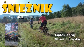
Oct 7, 2024 , Stronie Śląskie

23:01 |
93 |
Oct 7, 2024 , Stronie Śląskie
10:37 |
230 |
Oct 2, 2023 , Duszniki-Zdrój
Recent Trail Reports
| status | trail | date | condition | |
|---|---|---|---|---|
| Złoty Stok Niebieska | Jun 8, 2026 @ 10:34am (Europe/Prague) Jun 8, 2026 | view | ||
| Orłowiec Czerwona | Jun 8, 2026 @ 10:34am (Europe/Prague) Jun 8, 2026 | view | ||
| Orłowiec Niebieska 1 | Jun 8, 2026 @ 10:34am (Europe/Prague) Jun 8, 2026 | view | ||
| Złoty Stok Czerwona 2 | Jun 8, 2026 @ 10:34am (Europe/Prague) Jun 8, 2026 | view | ||
| Złoty Stok Czerwona 1 | Jun 8, 2026 @ 10:34am (Europe/Prague) Jun 8, 2026 | view |
Total Trails
56
Total Distance
143 miles
Total Descent
-21,549 ft
Total Climb
19,979 ft
close
-
Layers w
- Weather Layers
- Pro
- Pro
- Pro
- Pro
- Pro
- Pro
- More Layers
- Pro
- Pro
- Pro
- Pro
-
Upgrade to

3D
Trail Conditions
- Unknown
- Snow Groomed
- Snow Packed
- Snow Covered
- Snow Cover Partial
- Freeze/thaw Cycle
- Icy
- Prevalent Mud
- Wet
- Variable
- Ideal
- Dry
- Very Dry
Trail Flow (Ridden Direction)
Trailforks scans users ridelogs to determine the most popular direction each trail is ridden. A good flowing trail network will have most trails flowing in a single direction according to their intension.
The colour categories are based on what percentage of riders are riding a trail in its intended direction.
The colour categories are based on what percentage of riders are riding a trail in its intended direction.
- > 96%
- > 90%
- > 80%
- > 70%
- > 50%
- < 50%
- bi-directional trail
- no data
Trail Last Ridden
Trailforks scans ridelogs to determine the last time a trail was ridden.
- < 2 days
- < 1 week
- < 2 weeks
- < 1 month
- < 6 months
- > 6 months
Trail Ridden Direction
The intended direction a trail should be ridden.
- Downhill Only
- Downhill Primary
- Both Directions
- Uphill Primary
- Uphill Only
- One Direction
Contribute Details
Colors indicate trail is missing specified detail.
- Description
- Photos
- Description & Photos
- Videos
Trail Popularity ?
Trailforks scans ridelogs to determine which trails are ridden the most in the last 9 months.
Trails are compared with nearby trails in the same city region with a possible 25 colour shades.
Think of this as a heatmap, more rides = more kinetic energy = warmer colors.
- most popular
- popular
- less popular
- not popular
ATV/ORV/OHV Filter
Max Vehicle Width
inches
US Cell Coverage
Legend

Radar Time
Activity Recordings
Trailforks uses anonymized public activity data.
?
Activity Recordings
Trailforks uses anonymized public activity data.
?
Personal Heatmap
▶
Activity Types
all
/
none
▶
Options
2
Date range
month
–
Winter Trails
Warning
A routing network for winter maps does not exist. Selecting trails using the winter trails layer has been disabled.
Missing Trails
Most Popular
Least Popular
Trails are colored based on popularity. The more popular a trail is, the more red. Less popular trails trend towards green.
Jump Magnitude Heatmap
Heatmap of where riders jump on trails. Zoom in to see individual jumps, click circles to view jump details.
BC Backroad Status
![map legend]()
Service Road Atlas is a free to use, community-driven service for viewing and creating reports on the numerous back-country service roads around B.C. and Alberta.

Slope Aspect
Direction the slope faces
Trails Deemphasized
Trails are shown in grey.
Only show trails with no bike usage.
Suggested Layers
Based on selected activity type
Save the current map location and zoom level as your default home location whenever this page is loaded.
Save
Trail transparency
Average difficulty
Trails and Routes in List - Distance by Difficulty
Trails and Routes in List - Difficulty Totals
- By Gluedig
- #339 - 14,444 views