
| Type: |  Sight |
| Activities: |
|
-
115Checkins
-
0MTB
-
115Hike
-
0Moto
-
0Ski
From "Find a grave" website:
From "History of the Town of Wolcott" by Rev.Samuel Orcutt
published in 1874:
"PIKE'S HILL BURYING GROUND.
This ground was laid out about 1774, by a committee of the Society appointed to 'fix a place or places for burying grounds.' The ground is located on the north declivity of the hill adjoining the Alcox road, in a most picturesque place. Here but few graves were made, some of which were afterwards removed to the ground east at the foot of the same hill, about fifteen yet remaining. Graves continued to be made in this ground until 1805, when the one east was constructed, and all burying ceased in the old yard, it having been used but thirty years. Some five or six monuments remain having inscriptions on them; the other graves are indicated by small field stones"
***********
Note that the spellings of names changed through the years and especially when one is looking at old tombstones that have been warn down from erosion and human destruction some letters are hard to decipher. The Alcott's (Alcox) and the Blakeslee's (Blakslee) were related through marriage. Patience Blakeslee married Jesse Alcox. Mathew Blakeslee married Rhoda Beach..
************
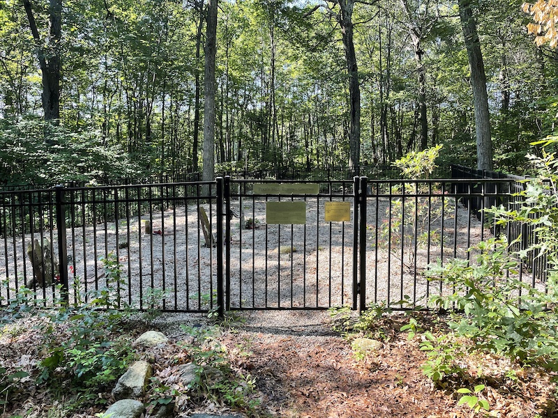
This small cemetery was hidden in the woods amongst the overgrown trees and shrubs and needed much tender loving care.
Boy Scout Steve Lago, his family, and Scout workers were able to clear the undergrowth, remove numerous large rocks, and cut down of several large trees to make room for a new fence .... The Town provided the money for the fence through a fund allocated for historic cemetery improvements.
Steve received a donation from the American Legion Auxiliary to purchase a sign that he placed at the entrance of the cemetery on the gate. Steve, his Mom, Dad, and sister also became very interested in the way the stones were placed and noted that each stone had a headstone as well as a smaller footstone. They were able to match each for most of the remaining stones.
Steve finished his Eagle Scout Project ... his wonderful efforts that have preserved yet another piece of history.
To view this cemetery, access it off of Woodtick Road just across from Wilson Road. You will see a sign on a tree that says "Tunxis Trail.". Hike the Tunxis Trail in about a quarter-mile, ...the cemetery on the right
https://www.findagrave.com/cemetery/2346586/pike%27s-hill-burying-ground
From "History of the Town of Wolcott" by Rev.Samuel Orcutt
published in 1874:
"PIKE'S HILL BURYING GROUND.
This ground was laid out about 1774, by a committee of the Society appointed to 'fix a place or places for burying grounds.' The ground is located on the north declivity of the hill adjoining the Alcox road, in a most picturesque place. Here but few graves were made, some of which were afterwards removed to the ground east at the foot of the same hill, about fifteen yet remaining. Graves continued to be made in this ground until 1805, when the one east was constructed, and all burying ceased in the old yard, it having been used but thirty years. Some five or six monuments remain having inscriptions on them; the other graves are indicated by small field stones"
***********
Note that the spellings of names changed through the years and especially when one is looking at old tombstones that have been warn down from erosion and human destruction some letters are hard to decipher. The Alcott's (Alcox) and the Blakeslee's (Blakslee) were related through marriage. Patience Blakeslee married Jesse Alcox. Mathew Blakeslee married Rhoda Beach..
************
This small cemetery was hidden in the woods amongst the overgrown trees and shrubs and needed much tender loving care.
Boy Scout Steve Lago, his family, and Scout workers were able to clear the undergrowth, remove numerous large rocks, and cut down of several large trees to make room for a new fence .... The Town provided the money for the fence through a fund allocated for historic cemetery improvements.
Steve received a donation from the American Legion Auxiliary to purchase a sign that he placed at the entrance of the cemetery on the gate. Steve, his Mom, Dad, and sister also became very interested in the way the stones were placed and noted that each stone had a headstone as well as a smaller footstone. They were able to match each for most of the remaining stones.
Steve finished his Eagle Scout Project ... his wonderful efforts that have preserved yet another piece of history.
To view this cemetery, access it off of Woodtick Road just across from Wilson Road. You will see a sign on a tree that says "Tunxis Trail.". Hike the Tunxis Trail in about a quarter-mile, ...the cemetery on the right
https://www.findagrave.com/cemetery/2346586/pike%27s-hill-burying-ground
close
3D
Trail Conditions
- Unknown
- Snow Groomed
- Snow Packed
- Snow Covered
- Snow Cover Partial
- Freeze/thaw Cycle
- Icy
- Prevalent Mud
- Wet
- Variable
- Ideal
- Dry
- Very Dry
Trail Flow (Ridden Direction)
Trailforks scans users activity logs to determine the most popular direction each trail is ridden. A good flowing trail network will have most trails flowing in a single direction according to their intension.
The colour categories are based on what percentage of users are riding a trail in its intended direction.
The colour categories are based on what percentage of users are riding a trail in its intended direction.
- > 96%
- > 90%
- > 80%
- > 70%
- > 50%
- < 50%
- bi-directional trail
- no data
Trail Last Used
Trailforks scans activity logs to determine the last time a trail was ridden.
- < 2 days
- < 1 week
- < 2 weeks
- < 1 month
- < 6 months
- > 6 months
Trail Ridden Direction
The intended direction a trail should be ridden.
- Downhill Only
- Downhill Primary
- Both Directions
- Uphill Primary
- Uphill Only
- One Direction
Contribute Details
Colors indicate trail is missing specified detail.
- Description
- Photos
- Description & Photos
- Videos
Trail Popularity ?
Trailforks scans activity logs to determine which trails are ridden the most in the last 9 months.
Trails are compared with nearby trails in the same city region with a possible 25 colour shades.
Think of this as a heatmap, more activities = more kinetic energy = warmer colors.
- most popular
- popular
- less popular
- not popular
ATV/ORV/OHV Filter
Max Vehicle Width
inches
US Cell Coverage
Legend

Radar Time
Activity Recordings
Trailforks uses anonymized public activity data.
?
Activity Recordings
Trailforks uses anonymized public activity data.
?
Winter Trails
Warning
A routing network for winter maps does not exist. Selecting trails using the winter trails layer has been disabled.
Missing Trails
Most Popular
Least Popular
Trails are colored based on popularity. The more popular a trail is, the more red. Less popular trails trend towards green.
Jump Magnitude Heatmap
Heatmap of where users jump on trails. Zoom in to see individual jumps, click circles to view jump details.
BC Backroad Status
![map legend]()
Service Road Atlas is a free to use, community-driven service for viewing and creating reports on the numerous back-country service roads around B.C. and Alberta.

Slope Aspect
Direction the slope faces
Trails Deemphasized
Trails are shown in grey.
Only show trails with no bike usage.
Suggested Layers
Based on selected activity type
Save the current map location and zoom level as your default home location whenever this page is loaded.
SaveAttached Trail
| trail name | difficulty | riding area |
|---|---|---|
| Woodtick Trail | Compounce Mountain |
Comments
We hope you've been enjoying Trailforks!
Create a FREE account to view POI comments and much more.
Other Points of Interest in Compounce Mountain
- By PlumbBobM
 TRAILFORKS HCH
- #73137