close
-
Layers w
- Weather Layers
- Pro
- Pro
- Pro
- Pro
- Pro
- Pro
- More Layers
- Pro
- Pro
- Pro
- Pro
-
Upgrade to

3D
Trail Conditions
- Unknown
- Snow Groomed
- Snow Packed
- Snow Covered
- Snow Cover Partial
- Freeze/thaw Cycle
- Icy
- Prevalent Mud
- Wet
- Variable
- Ideal
- Dry
- Very Dry
Trail Flow (Ridden Direction)
Trailforks scans users ridelogs to determine the most popular direction each trail is ridden. A good flowing trail network will have most trails flowing in a single direction according to their intension.
The colour categories are based on what percentage of riders are riding a trail in its intended direction.
The colour categories are based on what percentage of riders are riding a trail in its intended direction.
- > 96%
- > 90%
- > 80%
- > 70%
- > 50%
- < 50%
- bi-directional trail
- no data
Trail Last Ridden
Trailforks scans ridelogs to determine the last time a trail was ridden.
- < 2 days
- < 1 week
- < 2 weeks
- < 1 month
- < 6 months
- > 6 months
Trail Ridden Direction
The intended direction a trail should be ridden.
- Downhill Only
- Downhill Primary
- Both Directions
- Uphill Primary
- Uphill Only
- One Direction
Contribute Details
Colors indicate trail is missing specified detail.
- Description
- Photos
- Description & Photos
- Videos
Trail Popularity ?
Trailforks scans ridelogs to determine which trails are ridden the most in the last 9 months.
Trails are compared with nearby trails in the same city region with a possible 25 colour shades.
Think of this as a heatmap, more rides = more kinetic energy = warmer colors.
- most popular
- popular
- less popular
- not popular
ATV/ORV/OHV Filter
Max Vehicle Width
inches
US Cell Coverage
Legend

Radar Time
Activity Recordings
Trailforks uses anonymized public activity data.
?
Activity Recordings
Trailforks uses anonymized public activity data.
?
Personal Heatmap
▶
Activity Types
all
/
none
▶
Options
2
Date range
month
–
Winter Trails
Warning
A routing network for winter maps does not exist. Selecting trails using the winter trails layer has been disabled.
Missing Trails
Most Popular
Least Popular
Trails are colored based on popularity. The more popular a trail is, the more red. Less popular trails trend towards green.
Jump Magnitude Heatmap
Heatmap of where riders jump on trails. Zoom in to see individual jumps, click circles to view jump details.
BC Backroad Status
![map legend]()
Service Road Atlas is a free to use, community-driven service for viewing and creating reports on the numerous back-country service roads around B.C. and Alberta.

Slope Aspect
Direction the slope faces
Trails Deemphasized
Trails are shown in grey.
Only show trails with no bike usage.
Suggested Layers
Based on selected activity type
Save the current map location and zoom level as your default home location whenever this page is loaded.
SaveТрейл-парк, расположившийся на склонах горнолыжного центра Красная Горка и орестных склонов на территории первого цеха ковровского карьероуправления.
 google parking directions
Links
This region uses the Uk/Euro style trail grading system.
Activities Click to view
- Mountain Bike
24 trails
- E-Bike
24 trails
- Hike
16 trails
- Trail Running
16 trails
Region Details
- 6
- 4
- 2
- 7
- 3
- 1
Region Status
Open as of Jul 4, 2025Stats
- Avg Trail Rating
- Trails (view details)
- 24
- Trails Mountain Bike
- 24
- Trails E-Bike
- 24
- Trails Hike
- 16
- Trails Trail Running
- 16
- Total Distance
- 5 miles
- Total Descent
- 1,019 ft
- Total Vertical
- 121 ft
- Highest Trailhead
- 449 ft
- Reports
- 7
- Photos
- 19
- Ridden Counter
- 55
Popular 1-ый Цех Mountain Biking Trails
• 95 ★ 0.0 • 739 ft • 4 ft • 2 •
Popular red difficulty alpine singletrack. This mountain bike primary trail can be used downhill only and has a moderate overall physical rating with a 4 ft blue climb. It features rock garden. On average it takes 5 minutes to complete this trail.
• 60 ★ 0.0 • 208 ft • 0 ft • 2 •
Moderately popular black difficulty alpine singletrack. This mountain bike primary trail can be used downhill only and has a hard overall physical rating with a 0 ft green climb. On average it takes 3 minutes to complete this trail.
• 90 ★ 0.0 • 1,489 ft • 10 ft • 2 •
Popular blue difficulty family friendly singletrack. This mountain bike primary trail can be used downhill primary and has a moderate overall physical rating with a 10 ft blue climb. Trail visibility is always easy to follow. On average it takes 2 minutes to complete this trail.
• 100 ★ 0.0 • 519 ft • 0 ft • 2 •
Popular black difficulty singletrack. This mountain bike primary trail can be used downhill only and has a hard overall physical rating with a 0 ft green climb. It features jump, gap jump and rock garden. Trail visibility is always easy to follow. On average it takes 2 minutes to complete this trail.
• 100 ★ 0.0 • 953 ft • 5 ft • 2 •
Popular red difficulty singletrack. This mountain bike primary trail can be used downhill primary with a 5 ft blue climb. On average it takes 3 minutes to complete this trail.
• 50 ★ 0.0 • 856 ft • 5 ft • 1 •
Moderately popular red difficulty alpine singletrack. This mountain bike primary trail can be used downhill primary and has a moderate overall physical rating with a 5 ft green climb. It features drop, jump and gap jump. Trail visibility is sometimes hard to follow. On average it takes 4 minutes to complete this trail.
• 65 ★ 0.0 • 488 ft • 9 ft • 1 •
Moderately popular green difficulty family friendly singletrack. This mountain bike primary trail can be used downhill primary and has a easy overall physical rating with a 9 ft green climb. Trail visibility is always easy to follow. On average it takes 1 minutes to complete this trail.
• 55 ★ 0.0 • 2,014 ft • 31 ft • 1 •
Moderately popular blue difficulty singletrack. This mountain bike primary trail can be used both directions with a 31 ft blue climb. It features drop, jump and rock garden. On average it takes 5 minutes to complete this trail.
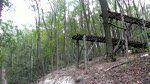
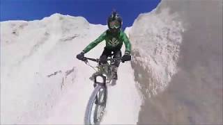
Photos of 1-ый Цех Mountain Bike

Recent Trail Reports
| status | trail | date | condition | info | user |
|---|---|---|---|---|---|
| Длинный | Dec 21, 2019 @ 10:36am Dec 21, 2019 | Dry | Antoxa |
Activity Feed
| username | action | type | title | date |
|---|---|---|---|---|
| CadoHavoc | difficultyvote | trail | activity #91047831 and 1 more | Mar 21, 2026 @ 11:12pm Mar 21, 2026 |
| Seba99 | wishlist | trail | activity #60484776 | Oct 14, 2024 @ 12:24pm Oct 14, 2024 |
| Antoxa | add | report | activity #7592238 | Dec 21, 2019 @ 10:36am Dec 21, 2019 |
| Dzot | vote | trail | activity #6408453 | Sep 14, 2019 @ 5:12am Sep 14, 2019 |
| Seba99 | wishlist | trail | activity #5846895 and 1 more | Aug 11, 2019 @ 12:54pm Aug 11, 2019 |
Activity Type Stats
| activitytype | trails | distance | descent | descent distance | total vertical | rating | global rank | state rank | photos | reports | routes | ridelogs |
|---|---|---|---|---|---|---|---|---|---|---|---|---|
| Mountain Bike | 24 | 5 miles | 1,020 ft | 2 miles | 121 ft | #8,204 | #49 | 19 | 7 | 270 | ||
| E-Bike | 24 | 5 miles | 1,020 ft | 2 miles | 121 ft | #2,351 | #18 | 2 | ||||
| Hike | 16 | 4 miles | 748 ft | 2 miles | 121 ft | #3,440 | #21 | 7 | 18 | |||
| Trail Running | 16 | 4 miles | 748 ft | 2 miles | 121 ft | #2,635 | 7 | 35 |
Frequently Asked Questions About 1-ый Цех
▼
What are the highest rated mountain biking trails in 1-ый Цех?
▼
Where can I park to ride in 1-ый Цех?
▼
What is the longest trail in 1-ый Цех?
The longest trail in 1-ый Цех is Южный трейл at 613.8 m. View all trails sorted by distance.
▼
How many trails are in 1-ый Цех?
1-ый Цех has a total of 24 trails. Browse top mountain biking trails in 1-ый Цех to find detailed information including difficulty ratings, distances, and trail conditions.
Activities
- By DrumminMan TBRU & contributors
- Admins: RWkos
- #24427 - 3,751 views
- 1-ый Цех activity log | embed map of 1-ый Цех mountain bike trails | 1-ый Цех mountain biking points of interest
Downloading of trail gps tracks in kml & gpx formats is enabled for 1-ый Цех.
You must login to download files.