close
-
Layers w
- Weather Layers
- Pro
- Pro
- Pro
- Pro
- Pro
- Pro
- More Layers
- Pro
- Pro
- Pro
- Pro
-
Upgrade to

3D
Trail Conditions
- Unknown
- Snow Groomed
- Snow Packed
- Snow Covered
- Snow Cover Partial
- Freeze/thaw Cycle
- Icy
- Prevalent Mud
- Wet
- Variable
- Ideal
- Dry
- Very Dry
Trail Flow (Ridden Direction)
Trailforks scans users ridelogs to determine the most popular direction each trail is ridden. A good flowing trail network will have most trails flowing in a single direction according to their intension.
The colour categories are based on what percentage of riders are riding a trail in its intended direction.
The colour categories are based on what percentage of riders are riding a trail in its intended direction.
- > 96%
- > 90%
- > 80%
- > 70%
- > 50%
- < 50%
- bi-directional trail
- no data
Trail Last Ridden
Trailforks scans ridelogs to determine the last time a trail was ridden.
- < 2 days
- < 1 week
- < 2 weeks
- < 1 month
- < 6 months
- > 6 months
Trail Ridden Direction
The intended direction a trail should be ridden.
- Downhill Only
- Downhill Primary
- Both Directions
- Uphill Primary
- Uphill Only
- One Direction
Contribute Details
Colors indicate trail is missing specified detail.
- Description
- Photos
- Description & Photos
- Videos
Trail Popularity ?
Trailforks scans ridelogs to determine which trails are ridden the most in the last 9 months.
Trails are compared with nearby trails in the same city region with a possible 25 colour shades.
Think of this as a heatmap, more rides = more kinetic energy = warmer colors.
- most popular
- popular
- less popular
- not popular
ATV/ORV/OHV Filter
Max Vehicle Width
inches
US Cell Coverage
Legend

Radar Time
Activity Recordings
Trailforks uses anonymized public activity data.
?
Activity Recordings
Trailforks uses anonymized public activity data.
?
Personal Heatmap
▶
Activity Types
all
/
none
▶
Options
2
Date range
month
–
Winter Trails
Warning
A routing network for winter maps does not exist. Selecting trails using the winter trails layer has been disabled.
Missing Trails
Most Popular
Least Popular
Trails are colored based on popularity. The more popular a trail is, the more red. Less popular trails trend towards green.
Jump Magnitude Heatmap
Heatmap of where riders jump on trails. Zoom in to see individual jumps, click circles to view jump details.
BC Backroad Status
![map legend]()
Service Road Atlas is a free to use, community-driven service for viewing and creating reports on the numerous back-country service roads around B.C. and Alberta.

Slope Aspect
Direction the slope faces
Trails Deemphasized
Trails are shown in grey.
Only show trails with no bike usage.
Suggested Layers
Based on selected activity type
Save the current map location and zoom level as your default home location whenever this page is loaded.
Save
No description for Abriès has been added yet!
Login or register to submit one.
This region uses the Uk/Euro style trail grading system.
Activities Click to view
- Mountain Bike
42 trails
- E-Bike
23 trails
- Adaptive Bike
2 trails
- Horse
0 trails
- Hike
39 trails
- Trail Running
33 trails
- Dirtbike/Moto
1 trails
- Observed Trials
1 trails
- ATV/ORV/OHV
1 trails
- Snowmobile
1 trails
- Snowshoe
1 trails
- Downhill Ski
22 trails
- Backcountry Ski
2 trails
- Nordic Ski
2 trails
Region Details
- 6
- 7
- 16
- 8
- 5
Region Status
Open as of Sep 18, 2025Stats
- Avg Trail Rating
- Trails (view details)
- 65
- Trails Mountain Bike
- 42
- Trails E-Bike
- 23
- Trails Gravel Bike
- 1
- Trails Adaptive Bike
- 2
- Trails Hike
- 39
- Trails Trail Running
- 33
- Trails Dirtbike/Moto
- 1
- Trails Observed Trials
- 1
- Trails ATV/ORV/OHV
- 1
- Trails Snowmobile
- 1
- Trails Snowshoe
- 1
- Trails Downhill Ski
- 22
- Trails Backcountry Ski
- 2
- Trails Nordic Ski
- 2
- Total Distance
- 76 miles
- Total Descent Distance
- 51 miles
- Total Descent
- 43,523 ft
- Total Vertical
- 4,618 ft
- Highest Trailhead
- 9,475 ft
- Reports
- 75
- Photos
- 12
- Ridden Counter
- 883
Articles
Exploring France's Secret Bike Parks - Abries
Oct 30, 2021 from pinkbike.com
Abries has to be the furthest away from the classic idea of a bike park or resort, but it features some incredible riding.
Sub Regions
-
Abries Bike Park
- 4
- 10
- 4
- 3
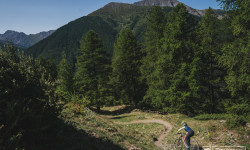
Popular Abriès Mountain Biking Trails
• ★ 0.0 • 3,976 ft • 0 ft • 33 •
Black difficulty alpine singletrack. This multi-use trail can be used both directions and has a extreme overall physical rating with a 0 ft black diamond climb. On average it takes 14 minutes to complete this trail.
• ★ 4.7 • 1 mile • 2 ft • 30 •
Red difficulty singletrack. This mountain bike primary trail can be used downhill only. On average it takes 11 minutes to complete this trail.
• ★ 4.0 • 3,625 ft • 707 ft • 29 • • hike
Blue difficulty singletrack. This hike primary trail.
• ★ 0.0 • 3,461 ft • 2 ft • 28 •
Blue difficulty singletrack. This mountain bike primary trail can be used downhill only. On average it takes 5 minutes to complete this trail.
• ★ 0.0 • 2,818 ft • 640 ft • 23 • • hike
Blue difficulty singletrack. This hike primary trail.
• ★ 0.0 • 2 miles • 67 ft • 22 •
Green difficulty singletrack. This mountain bike primary trail can be used downhill only. On average it takes 9 minutes to complete this trail.
• ★ 5.0 • 2,546 ft • 0 ft • 21 •
Black difficulty singletrack. This mountain bike primary trail can be used downhill only. On average it takes 4 minutes to complete this trail.
• ★ 5.0 • 3 miles • 34 ft • 19 • • hike
Blue difficulty singletrack. This hike primary trail with a 34 ft black diamond climb. On average it takes 29 minutes to complete this trail.
Abriès Mountain Bike Routes
8 miles • 1,425 ft • 0 • Loop •
Itinéraire complet en montagne au départ du sommet du télésiège de Gilly. Balisé toute l'année,...
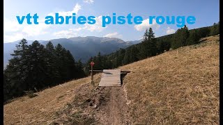
Videos of Abriès Mountain Bike
youtuber
![Pic du Malrif / GR58 | Abriès 2025]()
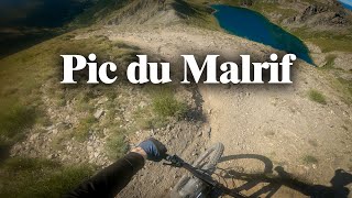
trail: Pic du Malrif
22:19 |
50 |
Aug 3, 2025 , Abriès
trail: Varenc
8:03 |
186 |
Jan 23, 2023 , Abriès
Recent Trail Reports
| status | trail | date | condition | info | user |
|---|---|---|---|---|---|
| Le Lombard | Sep 18, 2025 @ 12:51pm (Europe/Paris) Sep 18, 2025 | Very Dry | samale | ||
| Pic du Malrif | Sep 18, 2025 @ 12:51pm (Europe/Paris) Sep 18, 2025 | Very Dry | samale | ||
| Lac Ste Anne > Lac Miroir par le GR5 | Sep 18, 2025 @ 10:54am (Europe/Monaco) Sep 18, 2025 | Ideal | wolfiwolf | ||
| Bergerie du Lombard | Aug 25, 2025 @ 9:13am Aug 25, 2025 | Unknown | barolo71 | ||
| Cretes de La Lauzière | Aug 6, 2025 @ 8:06pm Aug 6, 2025 | Ideal | contrant | ||
| Les Eygliers | Jun 29, 2025 @ 7:39am Jun 29, 2025 | Dry | BryanbaEN8V | ||
| Widowmaker | Jun 21, 2025 @ 12:45pm Jun 21, 2025 | Variable | malonebenjamen | ||
| Montée de la piste d'Aiguilles | Aug 12, 2024 @ 10:08am Aug 12, 2024 | Dry | kardi13 TFSPAIN | ||
| La Viso | Aug 18, 2024 @ 9:53am Aug 18, 2024 | Ideal | kardi13 TFSPAIN | ||
| Varenc | Aug 18, 2024 @ 9:53am Aug 18, 2024 | Ideal | kardi13 TFSPAIN |
Activity Feed
| username | action | type | title | date |
|---|---|---|---|---|
| gerdi1 | ridden | trail | activity #98316451 | Jul 2, 2026 @ 11:45pm Jul 2, 2026 |
| alb-bdr | wishlist | trail | activity #97661981 and 5 more | Jun 23, 2026 @ 5:13pm Jun 23, 2026 |
| alb-bdr | wishlist | trail | activity #97661762 and 2 more | Jun 23, 2026 @ 5:10pm Jun 23, 2026 |
| samale | difficultyvote | trail | activity #96733564 | Jun 11, 2026 @ 6:38am Jun 11, 2026 |
| maikidita | wishlist | region | activity #96723578 | Jun 11, 2026 @ 1:18am Jun 11, 2026 |
Recent Comments
| username | type | title | comment | date |
|---|---|---|---|---|
| trail | it's a downhill trail or a is a access toRiva... | Aug 26, 2025 @ 7:24am Aug 26, 2025 | ||
| trail | Really nice trail. climb from Le Roux is... | Jun 28, 2025 @ 1:10pm Jun 28, 2025 | ||
| trail | Plutôt rouge que bleu. | Aug 22, 2024 @ 9:15am Aug 22, 2024 | ||
| trail | Mega geil! | Aug 13, 2024 @ 11:45am Aug 13, 2024 | ||
| trail | Sentier à faire en descente (aucun intérêt... | Jul 8, 2023 @ 1:32am Jul 8, 2023 |
Local Badges
-

Epic Ride Descent 2k21 awarded -

Descent 10k Badge1 awarded -

Descent 100k Badge0 awarded -

Epic Mountain Bike Climb 2k19 awarded -

Climbing 10k Badge1 awarded -

Mountain Biking 100k Badge0 awarded
Bike & Skill Parks
| name | type | city | rating |
|---|---|---|---|
| Abries Bike Park | bike park | Abriès |
Activity Type Stats
| activitytype | trails | distance | descent | descent distance | total vertical | rating | global rank | state rank | photos | reports | routes | ridelogs |
|---|---|---|---|---|---|---|---|---|---|---|---|---|
| Mountain Bike | 42 | 58 miles | 27,264 ft | 36 miles | 4,619 ft | #3,089 | #91 | 12 | 75 | 1 | 193 | |
| E-Bike | 23 | 28 miles | 12,858 ft | 17 miles | 4,619 ft | #3,435 | #200 | 69 | 1 | 36 | ||
| Gravel Bike | 1 | 4 miles | 23 ft | 3,960 ft | 1,194 ft | |||||||
| Adaptive Bike | 2 | 12 miles | 2,920 ft | 6 miles | 2,667 ft | #283 | #164 | |||||
| Hike | 39 | 58 miles | 25,869 ft | 34 miles | 4,619 ft | #3,398 | #84 | 75 | 104 | |||
| Trail Running | 33 | 52 miles | 22,195 ft | 29 miles | 4,619 ft | #3,604 | #117 | 74 | 3 | |||
| Dirtbike/Moto | 1 | 8 miles | 2,897 ft | 5 miles | 2,667 ft | #641 | #30 | 14 | ||||
| Observed Trials | 1 | 8 miles | 2,897 ft | 5 miles | 2,667 ft | #126 | #16 | |||||
| ATV/ORV/OHV | 1 | 8 miles | 2,897 ft | 5 miles | 2,667 ft | #435 | #25 | 14 | ||||
| Snowmobile | 1 | 8 miles | 2,897 ft | 5 miles | 2,667 ft | #93 | #2 | |||||
| Snowshoe | 1 | 8 miles | 2,897 ft | 5 miles | 2,667 ft | #227 | #10 | 9 | ||||
| Downhill Ski | 22 | 21 miles | 16,385 ft | 17 miles | 2,805 ft | #490 | #56 | 200 | ||||
| Backcountry Ski | 2 | 8 miles | 2,897 ft | 5 miles | 2,667 ft | #262 | #14 | 177 | ||||
| Nordic Ski | 2 | 8 miles | 2,897 ft | 5 miles | 2,667 ft | #417 | #15 | 41 |
Frequently Asked Questions About Abriès
▼
What are the best places to ride in Abriès?
Abriès has 2 areas to explore for mountain biking. The top rated areas are:
▼
What are the highest rated mountain biking trails in Abriès?
The highest rated mountain biking trails in Abriès are:
- Varenc (4.2/5)
- Pré Roubaud (4.1/5)
- La Ristourne (4.1/5)
- Lac Ste Anne > Lac Miroir par le GR5 (4.1/5)
- Cretes de La Lauzière (4/5)
▼
What is the best time of the year to ride in Abriès?
Based on ride log data, the most popular months to ride in Abriès are:
- June (3 activities)
- August (3 activities)
- December (1 activities)
▼
Where can I park to ride in Abriès?
There are 2 parking locations listed in Abriès. The most popular parking spots are:
Activities
Trails
- By elyari
 TRAILFORKS TFSPAIN & contributors
 - Admins: tomzaniroli, freerider48, provencemb, RobinzVLrBC
- #44001 - 2,526 views
- abriès activity log | embed map of Abriès mountain bike trails | abriès mountain biking points of interest
Downloading of trail gps tracks in kml & gpx formats is enabled for Abriès.
You must login to download files.