close
-
Layers w
- Weather Layers
- Pro
- Pro
- Pro
- Pro
- Pro
- Pro
- More Layers
- Pro
- Pro
- Pro
- Pro
-
Upgrade to

3D
Trail Conditions
- Unknown
- Snow Groomed
- Snow Packed
- Snow Covered
- Snow Cover Partial
- Freeze/thaw Cycle
- Icy
- Prevalent Mud
- Wet
- Variable
- Ideal
- Dry
- Very Dry
Trail Flow (Ridden Direction)
Trailforks scans users ridelogs to determine the most popular direction each trail is ridden. A good flowing trail network will have most trails flowing in a single direction according to their intension.
The colour categories are based on what percentage of riders are riding a trail in its intended direction.
The colour categories are based on what percentage of riders are riding a trail in its intended direction.
- > 96%
- > 90%
- > 80%
- > 70%
- > 50%
- < 50%
- bi-directional trail
- no data
Trail Last Ridden
Trailforks scans ridelogs to determine the last time a trail was ridden.
- < 2 days
- < 1 week
- < 2 weeks
- < 1 month
- < 6 months
- > 6 months
Trail Ridden Direction
The intended direction a trail should be ridden.
- Downhill Only
- Downhill Primary
- Both Directions
- Uphill Primary
- Uphill Only
- One Direction
Contribute Details
Colors indicate trail is missing specified detail.
- Description
- Photos
- Description & Photos
- Videos
Trail Popularity ?
Trailforks scans ridelogs to determine which trails are ridden the most in the last 9 months.
Trails are compared with nearby trails in the same city region with a possible 25 colour shades.
Think of this as a heatmap, more rides = more kinetic energy = warmer colors.
- most popular
- popular
- less popular
- not popular
ATV/ORV/OHV Filter
Max Vehicle Width
inches
US Cell Coverage
Legend

Radar Time
Activity Recordings
Trailforks uses anonymized public activity data.
?
Activity Recordings
Trailforks uses anonymized public activity data.
?
Personal Heatmap
▶
Activity Types
all
/
none
▶
Options
2
Date range
month
–
Winter Trails
Warning
A routing network for winter maps does not exist. Selecting trails using the winter trails layer has been disabled.
Missing Trails
Most Popular
Least Popular
Trails are colored based on popularity. The more popular a trail is, the more red. Less popular trails trend towards green.
Jump Magnitude Heatmap
Heatmap of where riders jump on trails. Zoom in to see individual jumps, click circles to view jump details.
BC Backroad Status
![map legend]()
Service Road Atlas is a free to use, community-driven service for viewing and creating reports on the numerous back-country service roads around B.C. and Alberta.

Slope Aspect
Direction the slope faces
Trails Deemphasized
Trails are shown in grey.
Only show trails with no bike usage.
Suggested Layers
Based on selected activity type
Save the current map location and zoom level as your default home location whenever this page is loaded.
Save
No description for Arth has been added yet!
Login or register to submit one.
This region uses the Uk/Euro style trail grading system.
Activities Click to view
- Mountain Bike
107 trails
- E-Bike
76 trails
- Hike
105 trails
- Trail Running
105 trails
Region Details
- 2
- 19
- 38
- 32
- 15
Region Status
Open as of May 31, 2026Stats
- Avg Trail Rating
- Trails (view details)
- 107
- Trails Mountain Bike
- 107
- Trails E-Bike
- 76
- Trails Hike
- 105
- Trails Trail Running
- 105
- Total Distance
- 49 miles
- Total Descent Distance
- 43 miles
- Total Descent
- 46,786 ft
- Total Vertical
- 3,788 ft
- Highest Trailhead
- 5,240 ft
- Reports
- 325
- Photos
- 34
- Ridden Counter
- 3,487
Popular Arth Mountain Biking Trails
• 90 ★ 4.0 • 2,139 ft • 0 ft • 108 • • hike
Highly rated popular blue difficulty alpine singletrack. This hike primary trail can be used both directions and has a hard overall physical rating with a 0 ft black diamond climb. Trail visibility is always easy to follow. On average it takes 6 minutes to complete this trail.
• 100 ★ 4.0 • 1 mile • 3 ft • 104 •
Popular green difficulty dirt/gravel road. This multi-use trail can be used both directions and has a hard overall physical rating with a 3 ft blue climb. Trail visibility is always easy to follow. On average it takes 31 minutes to complete this trail.
• 100 ★ 4.5 • 2 miles • 711 ft • 98 • • hike
Popular green difficulty singletrack. This hike primary trail can be used both directions. On average it takes 15 minutes to complete this trail.
• 80 ★ 0.0 • 2,428 ft • 4 ft • 87 • • hike
Popular blue difficulty singletrack. This hike primary trail can be used downhill primary and has a moderate overall physical rating with a 4 ft green climb. Trail visibility is always easy to follow. On average it takes 3 minutes to complete this trail.
• 75 ★ 0.0 • 2,067 ft • 0 ft • 85 • • hike
Popular blue difficulty singletrack. This hike primary trail can be used downhill primary and has a easy overall physical rating with a 0 ft green climb. Trail visibility is always easy to follow. On average it takes 3 minutes to complete this trail.
• 80 ★ 4.2 • 2,808 ft • 0 ft • 78 •
Popular green difficulty family friendly singletrack. This multi-use trail can be used downhill only and has a easy overall physical rating with a 0 ft green climb. It features bridge, jump and wallride. Trail visibility is always easy to follow. On average it takes 2 minutes to complete this trail.
• 95 ★ 3.0 • 423 ft • 0 ft • 75 •
Popular red difficulty singletrack. This multi-use trail can be used both directions. On average it takes minutes to complete this trail.
• 100 ★ 4.0 • 2,185 ft • 2 ft • 66 •
Popular blue difficulty singletrack. This multi-use trail can be used both directions and has a hard overall physical rating with a 2 ft blue climb. Trail visibility is always easy to follow. On average it takes 1 minutes to complete this trail.
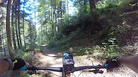
Photos of Arth Mountain Bike
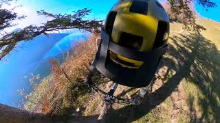
Videos of Arth Mountain Bike
trail: Markus DH
2:43 |
92 |
Jul 28, 2022

trail: Angerrain
10:23 |
182 |
Jul 9, 2024 , Arth
youtuber
![Enduro Biking Wildspitz Goldau]()
trail: GnipenTrail I
0:48 |
981 |
Nov 16, 2020 , Arth
Current Trail Warnings
| status | trail | date | condition | user | info |
|---|---|---|---|---|---|
| SchibiGnipenTrail | May 30, 2026 @ 4:03pm (Europe/Zurich) May 30, 2026 | Unknown | albezug | Trail is completely demolished after... |
Recent Trail Reports
| status | trail | date | condition | info | user |
|---|---|---|---|---|---|
| Jägerweg | May 31, 2026 @ 9:16am (Europe/Zurich) May 31, 2026 | Ideal | Arai84 | ||
| Grisselen | May 31, 2026 @ 9:16am (Europe/Zurich) May 31, 2026 | Ideal | Arai84 | ||
| Schüsseltrail | May 25, 2026 @ 12:14pm (Europe/Zurich) May 25, 2026 | Ideal | ChristophAlfons | ||
| Markus DH | May 25, 2026 @ 12:14pm (Europe/Zurich) May 25, 2026 | Ideal | ChristophAlfons | ||
| Blimoos I | May 25, 2026 @ 12:12pm (Europe/Zurich) May 25, 2026 | Unknown | ChristophAlfons | ||
| Blimoos 0 | May 25, 2026 @ 12:12pm (Europe/Zurich) May 25, 2026 | Unknown | ChristophAlfons | ||
| Schluchen | May 9, 2026 @ 9:47am (Europe/Zurich) May 9, 2026 | Ideal | Alexeggi | ||
| Bärensiten | May 9, 2026 @ 9:47am (Europe/Zurich) May 9, 2026 | Ideal | Alexeggi | ||
| Bannwald III | May 9, 2026 @ 9:47am (Europe/Zurich) May 9, 2026 | Ideal | Alexeggi | ||
| Bannwald II | May 9, 2026 @ 9:47am (Europe/Zurich) May 9, 2026 | Ideal | Alexeggi |
Activity Feed
| username | action | type | title | date |
|---|---|---|---|---|
| Arai84 | difficultyvote | trail | activity #96481030 and 1 more | Jun 7, 2026 @ 11:17am Jun 7, 2026 |
| Arai84 | ridden | trail | activity #96481023 | Jun 7, 2026 @ 11:17am Jun 7, 2026 |
| ThoStAdCa | wishlist | trail | activity #96017676 | Jun 1, 2026 @ 8:00am Jun 1, 2026 |
| Arai84 | add | report | activity #95948817 and 1 more | May 31, 2026 @ 9:23am May 31, 2026 |
| albezug | add | report | activity #95847792 | May 30, 2026 @ 7:03am May 30, 2026 |
Recent Comments
| username | type | title | comment | date |
|---|---|---|---|---|
| trail | Not a black trail, rather blue | Apr 29, 2026 @ 11:10am Apr 29, 2026 | ||
| trail | Very hard. Not realy bikable | May 2, 2025 @ 10:43am May 2, 2025 | ||
| trail | Most likely used as hikking path. Rideable... | Feb 23, 2025 @ 7:26am Feb 23, 2025 | ||
| trail | Weglos über zertrampelte Kuhweide. Lohnt... | Aug 10, 2024 @ 5:40am Aug 10, 2024 | ||
| trail | An schönen Wochenenden viele Wanderer... | May 23, 2024 @ 4:08am May 23, 2024 |
Local Badges
-
10 Red Trails20 awarded -

Epic Mountain Bike Climb 2k45 awarded -

Climbing 10k Badge12 awarded -

Mountain Biking 100k Badge0 awarded -

Epic Ride Descent 2k45 awarded -

Descent 10k Badge13 awarded
Activity Type Stats
| activitytype | trails | distance | descent | descent distance | total vertical | rating | global rank | state rank | photos | reports | routes | ridelogs |
|---|---|---|---|---|---|---|---|---|---|---|---|---|
| Mountain Bike | 107 | 48 miles | 45,909 ft | 42 miles | 3,789 ft | #3,181 | #48 | 34 | 325 | 3,215 | ||
| E-Bike | 76 | 36 miles | 34,085 ft | 32 miles | 3,789 ft | #2,659 | #101 | 299 | 1 | 422 | ||
| Hike | 105 | 47 miles | 45,627 ft | 42 miles | 3,789 ft | #2,155 | #47 | 314 | 612 | |||
| Trail Running | 105 | 47 miles | 45,627 ft | 42 miles | 3,789 ft | #3,028 | #52 | 314 | 231 |
Frequently Asked Questions About Arth
▼
What are the best places to ride in Arth?
▼
What are the highest rated mountain biking trails in Arth?
The highest rated mountain biking trails in Arth are:
- Jägerweg (4.3/5)
- In den Rohren (4.2/5)
- Gnippen - Roller Coaster (4.2/5)
- Herzig Flow (4.1/5)
- Gribsch (4.1/5)
▼
What is the best time of the year to ride in Arth?
Based on ride log data, the most popular months to ride in Arth are:
- April (2 activities)
- May (1 activities)
- November (1 activities)
▼
Where can I park to ride in Arth?
Check the Arth trail map for trailhead and parking information. Community members regularly update access and parking details for trails in the area.
Activities
Trails
Points of Interest
- By pstr
 Zürich & contributors
 - Admins: apply
- #36752 - 2,245 views
- arth activity log | embed map of Arth mountain bike trails | arth mountain biking points of interest
Downloading of trail gps tracks in kml & gpx formats is enabled for Arth.
You must login to download files.