close
-
Layers w
- Weather Layers
- Pro
- Pro
- Pro
- Pro
- Pro
- Pro
- More Layers
- Pro
- Pro
- Pro
- Pro
-
Upgrade to

3D
Trail Conditions
- Unknown
- Snow Groomed
- Snow Packed
- Snow Covered
- Snow Cover Partial
- Freeze/thaw Cycle
- Icy
- Prevalent Mud
- Wet
- Variable
- Ideal
- Dry
- Very Dry
Trail Flow (Ridden Direction)
Trailforks scans users ridelogs to determine the most popular direction each trail is ridden. A good flowing trail network will have most trails flowing in a single direction according to their intension.
The colour categories are based on what percentage of riders are riding a trail in its intended direction.
The colour categories are based on what percentage of riders are riding a trail in its intended direction.
- > 96%
- > 90%
- > 80%
- > 70%
- > 50%
- < 50%
- bi-directional trail
- no data
Trail Last Ridden
Trailforks scans ridelogs to determine the last time a trail was ridden.
- < 2 days
- < 1 week
- < 2 weeks
- < 1 month
- < 6 months
- > 6 months
Trail Ridden Direction
The intended direction a trail should be ridden.
- Downhill Only
- Downhill Primary
- Both Directions
- Uphill Primary
- Uphill Only
- One Direction
Contribute Details
Colors indicate trail is missing specified detail.
- Description
- Photos
- Description & Photos
- Videos
Trail Popularity ?
Trailforks scans ridelogs to determine which trails are ridden the most in the last 9 months.
Trails are compared with nearby trails in the same city region with a possible 25 colour shades.
Think of this as a heatmap, more rides = more kinetic energy = warmer colors.
- most popular
- popular
- less popular
- not popular
ATV/ORV/OHV Filter
Max Vehicle Width
inches
US Cell Coverage
Legend

Radar Time
Activity Recordings
Trailforks uses anonymized public activity data.
?
Activity Recordings
Trailforks uses anonymized public activity data.
?
Personal Heatmap
▶
Activity Types
all
/
none
▶
Options
2
Date range
month
–
Winter Trails
Warning
A routing network for winter maps does not exist. Selecting trails using the winter trails layer has been disabled.
Missing Trails
Most Popular
Least Popular
Trails are colored based on popularity. The more popular a trail is, the more red. Less popular trails trend towards green.
Jump Magnitude Heatmap
Heatmap of where riders jump on trails. Zoom in to see individual jumps, click circles to view jump details.
BC Backroad Status
![map legend]()
Service Road Atlas is a free to use, community-driven service for viewing and creating reports on the numerous back-country service roads around B.C. and Alberta.

Slope Aspect
Direction the slope faces
Trails Deemphasized
Trails are shown in grey.
Only show trails with no bike usage.
Suggested Layers
Based on selected activity type
Save the current map location and zoom level as your default home location whenever this page is loaded.
SaveThe plateau of the Ochil Hills is undulating with no prominent peak, the highest point being Ben Cleuch at 721 m (2,365 ft). The south-flowing burns have cut deep ravines including Dollar Glen, Silver Glen and Alva Glen, often only passable with the aid of wooden walkways.
This region has been created to cover the trails not covered by other riding areas.
This region has been created to cover the trails not covered by other riding areas.
Primary Trail Type: Cross-Country
 google parking directions
This region uses the Uk/Euro style trail grading system.
Activities Click to view
- Mountain Bike
25 trails
- E-Bike
17 trails
- Hike
25 trails
- Trail Running
25 trails
Region Details
- 1
- 3
- 2
- 13
- 6
Region Status
Open as of Sep 14, 2025Stats
- Avg Trail Rating
- Trails (view details)
- 25
- Trails Mountain Bike
- 25
- Trails E-Bike
- 17
- Trails Horse
- 2
- Trails Hike
- 25
- Trails Trail Running
- 25
- Trails Backcountry Ski
- 1
- Total Distance
- 12 miles
- Total Descent
- 4,982 ft
- Total Vertical
- 2,226 ft
- Highest Trailhead
- 2,352 ft
- Reports
- 55
- Photos
- 6
- Ridden Counter
- 957
Popular Ochil Hills Mountain Biking Trails
• 75 ★ 1.0 • 1 mile • 122 ft • 70 •
Popular red difficulty singletrack. This mountain bike primary trail. On average it takes 12 minutes to complete this trail.
• 95 ★ 1.0 • 3,743 ft • 173 ft • 57 •
Popular red difficulty singletrack. This mountain bike primary trail. On average it takes 8 minutes to complete this trail.
• 35 ★ 4.4 • 1 mile • 43 ft • 37 • • hike
Less popular black difficulty singletrack. This hike primary trail. On average it takes 35 minutes to complete this trail.
• 80 ★ 0.0 • 4,213 ft • 426 ft • 28 •
Popular red difficulty singletrack. This mountain bike primary trail. On average it takes 44 minutes to complete this trail.
• 85 ★ 2.0 • 1,198 ft • 0 ft • 27 • • hike
Popular green difficulty gravel path. This hike primary trail can be used both directions and has a moderate overall physical rating with a 0 ft blue climb. Trail visibility is always easy to follow. On average it takes 8 minutes to complete this trail.
• 65 ★ 2.0 • 801 ft • 43 ft • 23 • • hike
Moderately popular green difficulty gravel path. This hike primary trail can be used both directions and has a moderate overall physical rating with a 43 ft blue climb. It features bridge. Trail visibility is always easy to follow. On average it takes 2 minutes to complete this trail.
• 45 ★ 0.0 • 2,005 ft • 0 ft • 14 • • hike
Moderately popular red difficulty singletrack. This hike primary trail can be used downhill primary. On average it takes 2 minutes to complete this trail.
• 55 ★ 0.0 • 2,320 ft • 0 ft • 12 • • hike
Moderately popular black difficulty singletrack. This hike primary trail can be used both directions and has a moderate overall physical rating with a 0 ft black diamond climb. Trail visibility is always easy to follow. On average it takes 20 minutes to complete this trail.
Photos of Ochil Hills Mountain Bike
Videos of Ochil Hills Mountain Bike
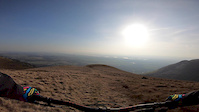
trail: Ben Buck - Ben Cleuch
0:00 |
175 |
Feb 25, 2019
trail: Trail
3:55 |
237 |
Sep 4, 2013
trail: Trail
0:14 |
166 |
Jun 22, 2013
trail: Trail
2:05 |
185 |
Jun 22, 2013
trail: Trail
3:35 |
379 |
Oct 12, 2010
Recent Trail Reports
| status | trail | date | condition | info | user |
|---|---|---|---|---|---|
| Ben Buck - Ben Cleuch | Sep 14, 2025 @ 9:57am (Europe/Isle_of_Man) Sep 14, 2025 | Dry | ddd333hhh | ||
| Ben Cleuch to Andrew Gannel Hill | Sep 14, 2025 @ 9:57am (Europe/Isle_of_Man) Sep 14, 2025 | Variable | ddd333hhh | ||
| Ben Cleuch- Ben Ever | Oct 4, 2024 @ 6:05am Oct 4, 2024 | Dry | Ochils | ||
| Tilly Glen Trail Upper | Jun 15, 2024 @ 3:06pm Jun 15, 2024 | Variable | stuartw OTA | ||
| Trail | Jan 24, 2024 @ 8:34am Jan 24, 2024 | Ideal | Ochils | ||
| Trail | Nov 8, 2023 @ 11:16am Nov 8, 2023 | Variable | ShoodNoBetter BCDC | ||
| Access Road | Nov 8, 2023 @ 11:16am Nov 8, 2023 | Ideal | ShoodNoBetter BCDC | ||
| Trail | Sep 13, 2023 @ 3:58am Sep 13, 2023 | Dry | Ochils | ||
| Nebit Path- Frontside/ The Gowls | Aug 16, 2022 @ 10:11pm Aug 16, 2022 | Dry | Ochils | ||
| Trail | Nov 9, 2020 @ 1:41am Nov 9, 2020 | Wet | gmcc |
Activity Feed
| username | action | type | title | date |
|---|---|---|---|---|
| deanofdrops | comment | trail | activity #83719890 | Nov 7, 2025 @ 7:19am Nov 7, 2025 |
| aag87 | update | trail | activity #83050813 | Oct 26, 2025 @ 7:07am Oct 26, 2025 |
| aag87 | add | trail | activity #82811849 and 1 more | Oct 22, 2025 @ 5:10am Oct 22, 2025 |
| RoddyRA6T7k | update | trail | activity #82667203 and 4 more | Oct 19, 2025 @ 11:15am Oct 19, 2025 |
| RoddyRA6T7k | add | poi | activity #82666636 and 1 more | Oct 19, 2025 @ 11:08am Oct 19, 2025 |
Recent Comments
| username | type | title | comment | date |
|---|---|---|---|---|
| trail | Since the last time I rode it, some knid soul... | Nov 7, 2025 @ 7:19am Nov 7, 2025 | ||
| trail | Split the 'Tilly Glen Trail' in two where the... | Oct 18, 2025 @ 10:21am Oct 18, 2025 | ||
| trail | Split the 'Tilly Glen Trail' in two where the... | Oct 18, 2025 @ 10:09am Oct 18, 2025 | ||
| trail | Extremely overgrown. I'd recommend giving it a... | Aug 24, 2025 @ 11:28am Aug 24, 2025 | ||
| trail | One of the worst mountain routes I have ever... | Aug 18, 2024 @ 3:03am Aug 18, 2024 |
Nearby Areas
| name | distance | ||||
|---|---|---|---|---|---|
| Woodhill wood | 1 | 3 | 1.9 km | ||
| Devon Vale | 7 | 1 | 2.7 km | ||
| Menstrie Glen | 11 | 3.8 km | |||
| Hillfoot Hill | 5 | 8 | 3.9 km | ||
| Gartmorn | 27 | 4 km |
Activity Type Stats
| activitytype | trails | distance | descent | descent distance | total vertical | rating | global rank | state rank | photos | reports | routes | ridelogs |
|---|---|---|---|---|---|---|---|---|---|---|---|---|
| Mountain Bike | 25 | 12 miles | 4,984 ft | 7 miles | 2,228 ft | #12,583 | #462 | 6 | 55 | 300 | ||
| E-Bike | 17 | 6 miles | 2,894 ft | 3 miles | 2,057 ft | #6,456 | #304 | 46 | 30 | |||
| Horse | 2 | 4,288 ft | 20 ft | 696 ft | 187 ft | 26 | ||||||
| Hike | 25 | 12 miles | 4,984 ft | 7 miles | 2,228 ft | #7,186 | #171 | 55 | 158 | |||
| Trail Running | 25 | 12 miles | 4,984 ft | 7 miles | 2,228 ft | #8,085 | #213 | 55 | 135 | |||
| Backcountry Ski | 1 |
Frequently Asked Questions About Ochil Hills
▼
What are the highest rated mountain biking trails in Ochil Hills?
The highest rated mountain biking trails in Ochil Hills are:
- Tilly Glen Trail Upper (4.1/5)
- Trail (3.8/5)
- Trail (3.7/5)
- Trail (3.7/5)
- Ben Buck - Ben Cleuch (3.6/5)
▼
What is the best time of the year to ride in Ochil Hills?
Based on ride log data, the most popular months to ride in Ochil Hills are:
- April (4 activities)
- September (2 activities)
- March (2 activities)
▼
Where can I park to ride in Ochil Hills?
There are 2 parking locations listed in Ochil Hills. The most popular parking spots are:
▼
What is the longest trail in Ochil Hills?
The longest trail in Ochil Hills is AG Hill - Glendevon Reservoir at 2.3 miles. View all trails sorted by distance.
Activities
Trails
- ochil hills activity log | embed map of Ochil Hills mountain bike trails | ochil hills mountain biking points of interest
Downloading of trail gps tracks in kml & gpx formats is enabled for Ochil Hills.
You must login to download files.