close
-
Layers w
- Weather Layers
- Pro
- Pro
- Pro
- Pro
- Pro
- Pro
- More Layers
- Pro
- Pro
- Pro
- Pro
-
Upgrade to

3D
Trail Conditions
- Unknown
- Snow Groomed
- Snow Packed
- Snow Covered
- Snow Cover Partial
- Freeze/thaw Cycle
- Icy
- Prevalent Mud
- Wet
- Variable
- Ideal
- Dry
- Very Dry
Trail Flow (Ridden Direction)
Trailforks scans users ridelogs to determine the most popular direction each trail is ridden. A good flowing trail network will have most trails flowing in a single direction according to their intension.
The colour categories are based on what percentage of riders are riding a trail in its intended direction.
The colour categories are based on what percentage of riders are riding a trail in its intended direction.
- > 96%
- > 90%
- > 80%
- > 70%
- > 50%
- < 50%
- bi-directional trail
- no data
Trail Last Ridden
Trailforks scans ridelogs to determine the last time a trail was ridden.
- < 2 days
- < 1 week
- < 2 weeks
- < 1 month
- < 6 months
- > 6 months
Trail Ridden Direction
The intended direction a trail should be ridden.
- Downhill Only
- Downhill Primary
- Both Directions
- Uphill Primary
- Uphill Only
- One Direction
Contribute Details
Colors indicate trail is missing specified detail.
- Description
- Photos
- Description & Photos
- Videos
Trail Popularity ?
Trailforks scans ridelogs to determine which trails are ridden the most in the last 9 months.
Trails are compared with nearby trails in the same city region with a possible 25 colour shades.
Think of this as a heatmap, more rides = more kinetic energy = warmer colors.
- most popular
- popular
- less popular
- not popular
ATV/ORV/OHV Filter
Max Vehicle Width
inches
US Cell Coverage
Legend

Radar Time
Activity Recordings
Trailforks uses anonymized public activity data.
?
Activity Recordings
Trailforks uses anonymized public activity data.
?
Personal Heatmap
▶
Activity Types
all
/
none
▶
Options
2
Date range
month
–
Winter Trails
Warning
A routing network for winter maps does not exist. Selecting trails using the winter trails layer has been disabled.
Missing Trails
Most Popular
Least Popular
Trails are colored based on popularity. The more popular a trail is, the more red. Less popular trails trend towards green.
Jump Magnitude Heatmap
Heatmap of where riders jump on trails. Zoom in to see individual jumps, click circles to view jump details.
BC Backroad Status
![map legend]()
Service Road Atlas is a free to use, community-driven service for viewing and creating reports on the numerous back-country service roads around B.C. and Alberta.

Slope Aspect
Direction the slope faces
Trails Deemphasized
Trails are shown in grey.
Only show trails with no bike usage.
Suggested Layers
Based on selected activity type
Save the current map location and zoom level as your default home location whenever this page is loaded.
SaveThe city of Bern or Berne (German: Bern, pronounced [bɛrn] ( listen); French: Berne [bɛʁn]; Italian: Berna [ˈbɛrna]; Romansh: Berna [ˈbɛrnə]; Berndeutsch/Bärndütsch (Bernese German): Bärn [b̥æːrn]) is the Bundesstadt (federal city, de facto capital) of Switzerland, and, with a population of 137,980 (end of 2013), is the fourth most populous city in Switzerland. The Bern agglomeration, which includes 36 municipalities, has a population of 328,616 in 2000. The metropolitan area had a population of 660,000 in 2000.[6] Bern is also the capital of the Canton of Bern, the second most populous of Switzerland's cantons.
The official language of Bern is (the Swiss variety of Standard) German, but the main spoken language is the Alemannic Swiss German dialect called Bernese German.
In 1983 the historic old town in the centre of Bern became a UNESCO World Heritage Site and Bern is ranked among the world’s top ten cities for the best quality of life (2010).
Links
This region uses the Uk/Euro style trail grading system.
Activities Click to view
- Mountain Bike
53 trails
- E-Bike
52 trails
- Hike
54 trails
- Trail Running
54 trails
Stats
- Avg Trail Rating
- Trails (view details)
- 54
- Trails Mountain Bike
- 53
- Trails E-Bike
- 52
- Trails Hike
- 54
- Trails Trail Running
- 54
- Total Distance
- 34 miles
- Total Descent Distance
- 15 miles
- Total Descent
- 4,922 ft
- Total Vertical
- 1,240 ft
- Highest Trailhead
- 2,827 ft
- Reports
- 436
- Photos
- 80
- Ridden Counter
- 4,526
Articles
Video: Claudio Caluori Introduces Pump Track BMXers to Alpine Enduro
Oct 15, 2019 from pinkbike.com
Eddy Clerté and Tommy Zula take a ride with Claudio Caluori to prepare for the Pump Track World Finals in Bern
Sub Regions
-
Chünizberg
- 17
-
Denteberg
- 2
-
Ostermundigeberg
- 4
Popular Bern Mountain Biking Trails
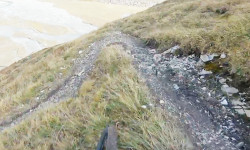
• 100 ★ 4.7 • 5 miles • 384 ft • 283 •
Einfache Runde (7,5 km) fast ganz auf Singletrack mit ein paar Sprüngen, Anliegern und vielen Kurven. Der Bremer–Loop im Bremgartenwald ist ein gemeinsames Projekt der Grundeigentümerin, des Sportamtes der Stadt Bern und dem Verein...
• 100 ★ 4.0 • 2,959 ft • 0 ft • 130 •
Steinbruch Trail on Ostermundigeberg. some nice rooty sections and a few fast parts. Be aware of slippery passages on the lower part with sand-stone sections in between and some water rills.
• 80 ★ 3.8 • 1 mile • 33 ft • 93 •
Flowy Cross Country Trail inbetween the Denteberg FSR and the main road. Some rooty sections, and some deep mudspots, but all in all easy/beginner level ride. You can ride the trail in both directions, so be aware of your counterpart....
• 95 ★ 4.0 • 3,950 ft • 10 ft • 67 •
Teil der längste Singletrail-Kombination im Könizbergwald. Einzelne Wurzelteppiche. Vorsicht: Wird in beide Richtungen befahren und kreuzt diverse Waldwege.
• 90 ★ 0.0 • 1,677 ft • 0 ft • 51 •
Short Connector to the hamlet-village of Rüti (belongs to Ostermundigen). Attention, at the end of trail - there's a fence, this is the end of the trail for bikers, further biking on the staircases to the village are prohibited! Please...
• 90 ★ 2.8 • 2,116 ft • 24 ft • 50 •
Kurzer Downhill-Singletrack auf der Westseite des Könizberg. Der Mittelteil des ursprünglichen Trails (Köniz bis Bern West) wurde von der Forst-Gemeinde aufgehoben und ist nichtmehr befahrbar. Der West und Ost Teil dieses Trails...
• 85 ★ 2.0 • 1,988 ft • 0 ft • 46 •
Short, easy and flowy downhill. A true HFR-Raiser if you climb it. Connects from/to .
• 75 ★ 4.0 • 663 ft • 7 ft • 42 •
Kurzer aber cooler Trail mit Kurven, Pumps und kleinen Sprüngen (sofern man will) Auch für Anfänger geeignet da nicht steil, guter Trail zum üben
Bern Mountain Bike Routes
17 miles • 2,761 ft • 3 •
Sunday Ride. Bremgartenloop, HiKatrail, Schwarzkopf
10 miles • 1,498 ft • 4 • Out & Back •
Als Warm-Up im Schosshaldenwald ein paar Runden auf dem angelegten MTB-Trail, danach via Ostermundigenwald...
14 miles • 2,946 ft • 3 • Loop •
Combines as many existing Trails as possible and avoids as many Roads and Hikingtrails as possible.
12 miles • 1,382 ft • 0 • Loop •
Rundfahrt ab Breitenrain via Schermenwald, Aare, Felsenau, Bremgartenwald zurück in den Breitenrain....
11 miles • 2,755 ft • 0 •
Photos of Bern Mountain Bike
Videos of Bern Mountain Bike
0:31 |
47 |
Apr 28, 2016
Recent Trail Reports
| status | trail | date | condition | info | user |
|---|---|---|---|---|---|
| Bremer-Loop | Jun 19, 2026 @ 3:57pm (Europe/Zurich) 18 hours | Dry | paraenggu VS-Admin | ||
| Forsthaus Bremer-Loop Connector | Jun 19, 2026 @ 3:56pm (Europe/Zurich) 18 hours | Ideal | paraenggu VS-Admin | ||
| Von Roll - Bremer | Jun 19, 2026 @ 3:56pm (Europe/Zurich) 18 hours | Ideal | paraenggu VS-Admin | ||
| Tubetränki | May 23, 2026 @ 10:35am (Europe/Zurich) May 23, 2026 | Ideal | uersu | ||
| Oh Tannliböim | May 23, 2026 @ 10:35am (Europe/Zurich) May 23, 2026 | Variable | uersu | ||
| Bikejasser | May 23, 2026 @ 10:35am (Europe/Zurich) May 23, 2026 | Ideal | uersu | ||
| Reservoir 1 | May 23, 2026 @ 10:35am (Europe/Zurich) May 23, 2026 | Ideal | uersu | ||
| Stärn SW upper | May 23, 2026 @ 10:35am (Europe/Zurich) May 23, 2026 | Ideal | uersu | ||
| al'Dente | May 23, 2026 @ 10:56am (Europe/Zurich) May 23, 2026 | Ideal | WGja5A | ||
| Steinbrüche Trail | May 3, 2026 @ 3:32pm (Europe/Zurich) May 3, 2026 | Ideal | doncortisone |
Activity Feed
| username | action | type | title | date |
|---|---|---|---|---|
| paraenggu | add | report | activity #97313970 and 2 more | Jun 19, 2026 @ 6:56am 18 hours |
| paraenggu | checkin | trail | activity #97313959 and 2 more | Jun 19, 2026 @ 6:56am 18 hours |
| Hadde | ridden | trail | activity #96373706 | Jun 6, 2026 @ 8:27am Jun 6, 2026 |
| Hadde | ridden | skillpark | activity #96373689 | Jun 6, 2026 @ 8:27am Jun 6, 2026 |
| RPs7JHI | ridden | trail | activity #96347777 | Jun 6, 2026 @ 1:26am Jun 6, 2026 |
Recent Comments
| username | type | title | comment | date |
|---|---|---|---|---|
| trail | Trail does not exist anymore. | Mar 18, 2026 @ 12:40am Mar 18, 2026 | ||
| trail | Nice trail for mountain unicycling. Different... | Aug 1, 2025 @ 2:30pm Aug 1, 2025 | ||
| trail | Im nördlichen Teil, im Aufstieg bevor man die... | Jun 21, 2025 @ 4:45am Jun 21, 2025 | ||
| trail | Trail ist derzeit in einem super Zustand! | May 31, 2025 @ 3:18am May 31, 2025 | ||
| trail | Sorry, falscher Trail | Feb 21, 2025 @ 8:54am Feb 21, 2025 |
Local Badges
-
Bremer-Loop x1013 awarded -

10 Green Trails76 awarded -

10 Blue Trails54 awarded -

Epic Ride Climb 2k174 awarded -

Climbing 10k Badge122 awarded -

Climbing 100k Badge14 awarded
Bike & Skill Parks
| name | type | city | rating |
|---|---|---|---|
| Pumptrack- und Velospielanlage Viererfeld | skill park | Bern | |
| Dirtpark Schiesskanal | skill park | Bern | |
| Pumptrack Weissenstein Bern | skill park | Bern | |
| Velo-Spielplatz Halenbrunnen | skill park | Bern |
Activity Type Stats
| activitytype | trails | distance | descent | descent distance | total vertical | rating | global rank | state rank | photos | reports | routes | ridelogs |
|---|---|---|---|---|---|---|---|---|---|---|---|---|
| Mountain Bike | 53 | 33 miles | 4,774 ft | 15 miles | 1,240 ft | #2,117 | #26 | 79 | 436 | 5 | 21,669 | |
| E-Bike | 52 | 32 miles | 4,731 ft | 15 miles | 1,198 ft | #1,102 | #65 | 1 | 380 | 2,111 | ||
| Hike | 54 | 34 miles | 4,921 ft | 15 miles | 1,240 ft | #1,770 | #36 | 431 | 470 | |||
| Trail Running | 54 | 34 miles | 4,921 ft | 15 miles | 1,240 ft | #1,306 | #30 | 429 | 914 |
Frequently Asked Questions About Bern
▼
What are the best places to ride in Bern?
Bern has 3 areas to explore for mountain biking. The top rated areas are:
▼
What are the highest rated mountain biking trails in Bern?
The highest rated mountain biking trails in Bern are:
- Bremer-Loop (4.5/5)
- Bodenweid (4.1/5)
- Underried (4.1/5)
- Grüne Perle (4.1/5)
- Steinbrüche Trail (4.1/5)
▼
What is the best time of the year to ride in Bern?
Based on ride log data, the most popular months to ride in Bern are:
- September (81 activities)
- August (80 activities)
- October (71 activities)
▼
Where can I park to ride in Bern?
There are 1 parking locations listed in Bern. The most popular parking spots are:
Activities
Trails
- By weeesel & contributors
- Admins: Trailnet Bern, daflow17, paraenggu
- #5261 - 20,250 views
- bern activity log | embed map of Bern mountain bike trails | bern mountain biking points of interest
Downloading of trail gps tracks in kml & gpx formats is enabled for Bern.
You must login to download files.