close
-
Layers w
- Weather Layers
- Pro
- Pro
- Pro
- Pro
- Pro
- Pro
- More Layers
- Pro
- Pro
- Pro
- Pro
-
Upgrade to

3D
Trail Conditions
- Unknown
- Snow Groomed
- Snow Packed
- Snow Covered
- Snow Cover Partial
- Freeze/thaw Cycle
- Icy
- Prevalent Mud
- Wet
- Variable
- Ideal
- Dry
- Very Dry
Trail Flow (Ridden Direction)
Trailforks scans users ridelogs to determine the most popular direction each trail is ridden. A good flowing trail network will have most trails flowing in a single direction according to their intension.
The colour categories are based on what percentage of riders are riding a trail in its intended direction.
The colour categories are based on what percentage of riders are riding a trail in its intended direction.
- > 96%
- > 90%
- > 80%
- > 70%
- > 50%
- < 50%
- bi-directional trail
- no data
Trail Last Ridden
Trailforks scans ridelogs to determine the last time a trail was ridden.
- < 2 days
- < 1 week
- < 2 weeks
- < 1 month
- < 6 months
- > 6 months
Trail Ridden Direction
The intended direction a trail should be ridden.
- Downhill Only
- Downhill Primary
- Both Directions
- Uphill Primary
- Uphill Only
- One Direction
Contribute Details
Colors indicate trail is missing specified detail.
- Description
- Photos
- Description & Photos
- Videos
Trail Popularity ?
Trailforks scans ridelogs to determine which trails are ridden the most in the last 9 months.
Trails are compared with nearby trails in the same city region with a possible 25 colour shades.
Think of this as a heatmap, more rides = more kinetic energy = warmer colors.
- most popular
- popular
- less popular
- not popular
ATV/ORV/OHV Filter
Max Vehicle Width
inches
US Cell Coverage
Legend

Radar Time
Activity Recordings
Trailforks uses anonymized public activity data.
?
Activity Recordings
Trailforks uses anonymized public activity data.
?
Personal Heatmap
▶
Activity Types
all
/
none
▶
Options
2
Date range
month
–
Winter Trails
Warning
A routing network for winter maps does not exist. Selecting trails using the winter trails layer has been disabled.
Missing Trails
Most Popular
Least Popular
Trails are colored based on popularity. The more popular a trail is, the more red. Less popular trails trend towards green.
Jump Magnitude Heatmap
Heatmap of where riders jump on trails. Zoom in to see individual jumps, click circles to view jump details.
BC Backroad Status
![map legend]()
Service Road Atlas is a free to use, community-driven service for viewing and creating reports on the numerous back-country service roads around B.C. and Alberta.

Slope Aspect
Direction the slope faces
Trails Deemphasized
Trails are shown in grey.
Only show trails with no bike usage.
Suggested Layers
Based on selected activity type
Save the current map location and zoom level as your default home location whenever this page is loaded.
Save
No description for Bras has been added yet!
Login or register to submit one.
Links
This region uses the Uk/Euro style trail grading system.
Activities Click to view
- Mountain Bike
15 trails
- E-Bike
4 trails
- Hike
11 trails
- Trail Running
11 trails
Region Details
- 3
- 2
- 1
- 9
Region Status
Open as of May 12, 2026Stats
- Avg Trail Rating
- Trails (view details)
- 15
- Trails Mountain Bike
- 15
- Trails E-Bike
- 4
- Trails Hike
- 11
- Trails Trail Running
- 11
- Total Distance
- 10 miles
- Total Descent
- 5,279 ft
- Total Vertical
- 729 ft
- Highest Trailhead
- 1,849 ft
- Reports
- 36
- Ridden Counter
- 546
Sub Regions
-
Cochonduro
Popular Bras Mountain Biking Trails
• 95 ★ 5.0 • 1 mile • 0 ft • 65 •
Single dans de la roche majoritairement, avec une fin plutôt rapide et flowy et des petits sauts.
• 85 ★ 0.0 • 1,270 ft • 0 ft • 50 •
Variante de la demi-molle, partageant la même fin. Début engagé dans la roche, puis portion dans de la terre noire de type terreau et fin rapide
• 35 ★ 0.0 • 4,984 ft • 0 ft • 47 •
Single mixant de la roche et de la terre. Attention : glissante lorsque c'est humide, mais praticable car moins engagée.
• 45 ★ 0.0 • 2,287 ft • 92 ft • 46 •
Moderately popular green difficulty singletrack. This mountain bike primary trail can be used uphill primary. On average it takes 9 minutes to complete this trail.
• 5 ★ 5.0 • 4,921 ft • 26 ft • 44 •
Less popular black difficulty singletrack. This mountain bike primary trail can be used downhill only and has a hard overall physical rating with a 26 ft double black diamond climb. On average it takes 11 minutes to complete this trail.
• 70 ★ 5.0 • 4,552 ft • 82 ft • 34 •
Popular black difficulty singletrack. This mountain bike primary trail can be used downhill only and has a hard overall physical rating with a 82 ft black diamond climb. On average it takes 6 minutes to complete this trail.
• 100 ★ 4.0 • 3,333 ft • 0 ft • 27 •
Variante des Iris. Pierrier puis virages serrés et fin ave des virages à plat.
Bras Mountain Bike Routes
★ 5.0 • 17 miles • 3,853 ft • 9 • Race •
Tracé de l'Enduro VTT Cochonduro 2023 de Bras dans le Var ! 5 spéciales sur des terrains variés,...
Videos of Bras Mountain Bike
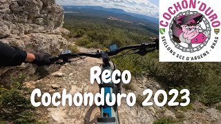
trail: La Gaby (Bourville)
31:41 |
148 |
Apr 10, 2023 , Bras

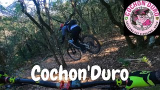
trail: La Brûlée
31:41 |
220 |
Apr 10, 2023 , Bras

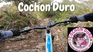
trail: La 3 poteaux
19:34 |
90 |
Mar 4, 2022 , Bras

trail: Les Iris
19:34 |
144 |
Mar 4, 2022 , Bras

trail: La Tic Tac Toc
19:34 |
214 |
Mar 4, 2022 , Bras

trail: Extra-molle Terres Noires
19:34 |
76 |
Mar 4, 2022 , Bras
trail: La Demi Molle
19:34 |
171 |
Mar 4, 2022 , Bras
trail: La Brûlée
22:45 |
107 |
Feb 21, 2022 , Bras
Recent Trail Reports
| status | trail | date | condition | info | user |
|---|---|---|---|---|---|
| La Brûlée | May 12, 2026 @ 6:02pm (Europe/Paris) May 12, 2026 | Variable | jojolindouille | ||
| Les Cretes variante | Dec 28, 2025 @ 10:32am (Europe/Monaco) Dec 28, 2025 | Wet | BD06 | ||
| Connecteur | Dec 28, 2025 @ 10:32am (Europe/Monaco) Dec 28, 2025 | Wet | BD06 | ||
| Gargamelle (épingles) | Dec 13, 2025 @ 1:11pm (Europe/Monaco) Dec 13, 2025 | Unknown | Petoulet | ||
| Passerelle sablière | May 24, 2025 @ 8:45am May 24, 2025 | Dry | Petoulet | ||
| Les Iris | May 24, 2025 @ 8:45am May 24, 2025 | Dry | Petoulet | ||
| La Gaby (Bourville) | May 24, 2025 @ 8:45am May 24, 2025 | Ideal | Petoulet | ||
| La Tic Tac Toc | Jun 22, 2024 @ 11:27pm Jun 22, 2024 | Very Dry | Petoulet | ||
| Extra-molle Terres Noires | Feb 26, 2022 @ 1:01am Feb 26, 2022 | Dry | benoitscfr | ||
| La 3 poteaux | Feb 26, 2022 @ 1:01am Feb 26, 2022 | Dry | benoitscfr |
Activity Feed
| username | action | type | title | date |
|---|---|---|---|---|
| jojolindouille | add | report | activity #94562638 | May 12, 2026 @ 9:02am May 12, 2026 |
| akichnakich | wishlist | region | activity #92923078 | Apr 19, 2026 @ 12:35am Apr 19, 2026 |
| Tomaskills | wishlist | route | activity #91453849 | Mar 28, 2026 @ 10:55am Mar 28, 2026 |
| Pengle | wishlist | region | activity #91451768 | Mar 28, 2026 @ 10:32am Mar 28, 2026 |
| BD06 | add | report | activity #86207128 and 2 more | Dec 28, 2025 @ 6:31am Dec 28, 2025 |
Recent Comments
| username | type | title | comment | date |
|---|---|---|---|---|
| trail | Spéciale nommée "La Bourville" ou "La Gaby"... | Mar 30, 2023 @ 3:23am Mar 30, 2023 | ||
| trail | Spéciale nommée "La Brûlée" par les locaux. | Mar 30, 2023 @ 3:22am Mar 30, 2023 | ||
| trail | La 3 poteaux | Mar 27, 2023 @ 5:12am Mar 27, 2023 | ||
| trail | Extra-molle Terres Noires (milieu) | Mar 27, 2023 @ 5:11am Mar 27, 2023 | ||
| trail | De loin ma préférée juste du plaisir en barre. | Sep 3, 2015 @ 12:18pm Sep 3, 2015 |
Local Badges
-

Epic Ride Climb 2k8 awarded -

Climbing 10k Badge11 awarded -

Climbing 100k Badge1 awarded -

Epic Ride Descent 2k8 awarded -

Descent 10k Badge11 awarded -

Descent 100k Badge1 awarded
Activity Type Stats
| activitytype | trails | distance | descent | descent distance | total vertical | rating | global rank | state rank | photos | reports | routes | ridelogs |
|---|---|---|---|---|---|---|---|---|---|---|---|---|
| Mountain Bike | 15 | 10 miles | 5,279 ft | 7 miles | 728 ft | #6,934 | #311 | 36 | 1 | 947 | ||
| E-Bike | 4 | 3 miles | 604 ft | 5,279 ft | 577 ft | #7,336 | #584 | 33 | 1 | 237 | ||
| Hike | 11 | 7 miles | 3,146 ft | 4 miles | 728 ft | #9,698 | #459 | 34 | 48 | |||
| Trail Running | 11 | 7 miles | 3,146 ft | 4 miles | 728 ft | #9,192 | #434 | 34 | 5 |
Frequently Asked Questions About Bras
▼
What are the best places to ride in Bras?
Bras has 1 areas to explore for mountain biking.
▼
What are the highest rated mountain biking trails in Bras?
The highest rated mountain biking trails in Bras are:
- La Brûlée (4.1/5)
- La Demi Molle (4.1/5)
- Les Iris (4.1/5)
- La Tic Tac Toc (4.1/5)
- La 3 poteaux (4/5)
▼
What is the best time of the year to ride in Bras?
Based on ride log data, the most popular months to ride in Bras are:
- August (11 activities)
- September (8 activities)
- April (8 activities)
▼
Where can I park to ride in Bras?
Check the Bras trail map for trailhead and parking information. Community members regularly update access and parking details for trails in the area.
- By hpman83
 TRAILFORKS TFFRANCE & contributors
 - Admins: apply
- #7823 - 2,621 views
- bras activity log | embed map of Bras mountain bike trails |
Downloading of trail gps tracks in kml & gpx formats is enabled for Bras.
You must login to download files.