close
-
Layers w
- Weather Layers
- Pro
- Pro
- Pro
- Pro
- Pro
- Pro
- More Layers
- Pro
- Pro
- Pro
- Pro
-
Upgrade to

3D
Trail Conditions
- Unknown
- Snow Groomed
- Snow Packed
- Snow Covered
- Snow Cover Partial
- Freeze/thaw Cycle
- Icy
- Prevalent Mud
- Wet
- Variable
- Ideal
- Dry
- Very Dry
Trail Flow (Ridden Direction)
Trailforks scans users ridelogs to determine the most popular direction each trail is ridden. A good flowing trail network will have most trails flowing in a single direction according to their intension.
The colour categories are based on what percentage of riders are riding a trail in its intended direction.
The colour categories are based on what percentage of riders are riding a trail in its intended direction.
- > 96%
- > 90%
- > 80%
- > 70%
- > 50%
- < 50%
- bi-directional trail
- no data
Trail Last Ridden
Trailforks scans ridelogs to determine the last time a trail was ridden.
- < 2 days
- < 1 week
- < 2 weeks
- < 1 month
- < 6 months
- > 6 months
Trail Ridden Direction
The intended direction a trail should be ridden.
- Downhill Only
- Downhill Primary
- Both Directions
- Uphill Primary
- Uphill Only
- One Direction
Contribute Details
Colors indicate trail is missing specified detail.
- Description
- Photos
- Description & Photos
- Videos
Trail Popularity ?
Trailforks scans ridelogs to determine which trails are ridden the most in the last 9 months.
Trails are compared with nearby trails in the same city region with a possible 25 colour shades.
Think of this as a heatmap, more rides = more kinetic energy = warmer colors.
- most popular
- popular
- less popular
- not popular
ATV/ORV/OHV Filter
Max Vehicle Width
inches
US Cell Coverage
Legend

Radar Time
Activity Recordings
Trailforks uses anonymized public activity data.
?
Activity Recordings
Trailforks uses anonymized public activity data.
?
Personal Heatmap
▶
Activity Types
all
/
none
▶
Options
2
Date range
month
–
Winter Trails
Warning
A routing network for winter maps does not exist. Selecting trails using the winter trails layer has been disabled.
Missing Trails
Most Popular
Least Popular
Trails are colored based on popularity. The more popular a trail is, the more red. Less popular trails trend towards green.
Jump Magnitude Heatmap
Heatmap of where riders jump on trails. Zoom in to see individual jumps, click circles to view jump details.
BC Backroad Status
![map legend]()
Service Road Atlas is a free to use, community-driven service for viewing and creating reports on the numerous back-country service roads around B.C. and Alberta.

Slope Aspect
Direction the slope faces
Trails Deemphasized
Trails are shown in grey.
Only show trails with no bike usage.
Suggested Layers
Based on selected activity type
Save the current map location and zoom level as your default home location whenever this page is loaded.
Save
No description for Briançon has been added yet!
Login or register to submit one.
This region uses the Uk/Euro style trail grading system.
Activities Click to view
- Mountain Bike
124 trails
- E-Bike
102 trails
- Gravel Bike
0 trails
- Adaptive Bike
0 trails
- Horse
6 trails
- Hike
84 trails
- Trail Running
84 trails
- Dirtbike/Moto
0 trails
- Observed Trials
0 trails
- ATV/ORV/OHV
1 trails
- Snowmobile
0 trails
- Snowshoe
0 trails
- Downhill Ski
132 trails
- Backcountry Ski
0 trails
- Nordic Ski
1 trails
Region Details
- 25
- 7
- 35
- 45
- 10
Region Status
Open as of Apr 20, 2026Stats
- Avg Trail Rating
- Trails (view details)
- 255
- Trails Mountain Bike
- 125
- Trails E-Bike
- 102
- Trails Horse
- 6
- Trails Hike
- 84
- Trails Trail Running
- 84
- Trails ATV/ORV/OHV
- 1
- Trails Downhill Ski
- 132
- Trails Nordic Ski
- 1
- Total Distance
- 208 miles
- Total Descent
- 152,620 ft
- Total Vertical
- 5,787 ft
- Highest Trailhead
- 9,068 ft
- Reports
- 240
- Photos
- 61
- Ridden Counter
- 15,100
Articles
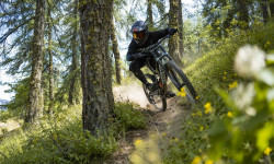
Video: Maxime Peythieu Styles Through Serre Chevalier Bike Park's Flowy Trails
Nov 23, 2019 from pinkbike.com
Dreamy, deserted trails welcome Maxime on his first-ever ride on a downhill bike.
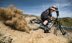
Video: Finding Flow in France's Stunning Serre Chevalier Bike Park
Nov 2, 2019 from pinkbike.com
Morgane Such rides Serre Chevalier Bike Park's fun, flowy trails.
Sub Regions
-
Serre Chevalier Bike Park
- 2
- 16
- 27
- 3
Popular Briançon Mountain Biking Trails
• 95 ★ 4.0 • 2 miles • 37 ft • 210 • • hike
Right after Col du Granon, allows you to finish your ride at Briancon fortified city
• 100 ★ 4.4 • 1 mile • 21 ft • 196 •
Highly rated popular blue difficulty singletrack. This mountain bike primary trail can be used one direction. On average it takes 5 minutes to complete this trail.
• 90 ★ 4.2 • 3 miles • 279 ft • 178 • • hike
A long and awesome natural trail, a must-do in this region
• 85 ★ 4.0 • 3,274 ft • 13 ft • 142 •
Popular red difficulty machine groomed. This mountain bike primary trail can be used one direction. It features jump and skinny. On average it takes 4 minutes to complete this trail.
• 85 ★ 4.5 • 2 miles • 0 ft • 137 • • hike
Highly rated popular blue difficulty singletrack. This hike primary trail can be used downhill primary. On average it takes 16 minutes to complete this trail.
• 100 ★ 4.9 • 2 miles • 3 ft • 135 • • hike
Longue et superbe spéciale, une vraie belle descente d'enduro ! Long and beautiful downhill, a true great enduro stage ! Possibilité de partir du sommet du fort, la vue est splendide ! Possibility to start from the top of the fort,...
• 100 ★ 4.0 • 1 mile • 9 ft • 123 •
Takes you down some of French DH National Championship track
Briançon Mountain Bike Routes
11 miles • 1,137 ft • 6 • Point to Point •
Départ du , monter sous le col des Cibière par une piste caillouteuse. Descendre à St Joseph puis...
★ 2.4 • 8 miles • 1,104 ft • 2 • Point to Point •
Start from the chairlift La Casse du Boeuf. Ridge trail with beautiful landscape. Downhill to Monêtier....
12 miles • 3,509 ft • 2 • Loop •
Départ du champ de Mars, monter en face jusqu’au fort des Sallettes. juste avant le fort grimper par un...
9 miles • 861 ft • 0 • Point to Point •
One of the best trail of Serre Chevalier. Start from Col du Granon (easy to shuttle to avoid the climb by...
9 miles • 2,056 ft • 0 • Loop •
Start from le Monêtier les Bains, go up in the Valley to Le Lauzet. Then climb just below the Aiguillette...
7 miles • 130 ft • 0 • Point to Point •
Drops off the back of the bike park, following tracks across open alpine grass before dropping down in...
Photos of Briançon Mountain Bike
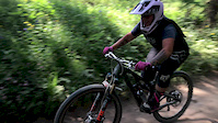
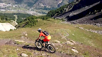
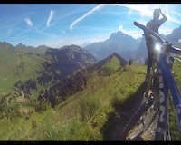
Videos of Briançon Mountain Bike
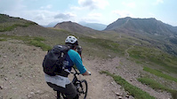
trail: L’Orée du Bois part 2
0:10 |
51 |
Apr 9, 2020
trail: L’Orée du Bois part 2
0:09 |
54 |
Apr 9, 2020
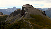
trail: Col du Granon
27:22 |
421 |
Aug 17, 2019
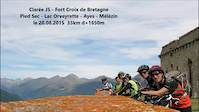
trail: Croix de Bretagne
8:54 |
541 |
Jan 3, 2016
trail: Col du Granon
8:44 |
613 |
Dec 23, 2015
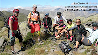
trail: La Tabaz'co
2:45 |
1349 |
Aug 24, 2015
2:36 |
251 |
Aug 28, 2014
trail: Mines
3:20 |
457 |
Oct 16, 2013
Recent Trail Reports
| status | trail | date | condition | info | user |
|---|---|---|---|---|---|
| Villard Laté | Apr 20, 2026 @ 6:25pm (Europe/Monaco) Apr 20, 2026 | Ideal | emilec7 | ||
| Le Coin | Apr 20, 2026 @ 6:25pm (Europe/Monaco) Apr 20, 2026 | Very Dry | emilec7 | ||
| Descente Du Bois De L'Ours | Apr 23, 2026 @ 3:59pm (Europe/Monaco) Apr 23, 2026 | Dry | emilec7 | ||
| Chemin de Clos de Brun | Apr 23, 2026 @ 3:59pm (Europe/Monaco) Apr 23, 2026 | Ideal | emilec7 | ||
| Sentier de la Guisane | Feb 24, 2026 @ 6:22pm (Europe/Paris) Feb 24, 2026 | Snow Packed | emilec7 | ||
| Villard laté #1 | Oct 20, 2025 @ 6:30pm (Europe/Monaco) Oct 20, 2025 | Ideal | emilec7 | ||
| Bois de Monsieur | Sep 23, 2025 @ 9:32am (Europe/Paris) Sep 23, 2025 | Variable | samale | ||
| L'infernet | Sep 9, 2025 @ 7:38am Sep 9, 2025 | Wet | Klaare | ||
| Pied-Sec | Sep 6, 2025 @ 10:56am Sep 6, 2025 | Ideal | Florentg1707 VMBC | ||
| Col des Cibières | Aug 15, 2025 @ 7:11pm Aug 15, 2025 | Dry | emilec7 |
Activity Feed
| username | action | type | title | date |
|---|---|---|---|---|
| CZy4Yp | ridden | trail | activity #96536534 and 1 more | Jun 8, 2026 @ 6:55am 2 days |
| CZy4Yp | ridden | trail | activity #96536435 and 1 more | Jun 8, 2026 @ 6:53am 2 days |
| B8Q1Ze | ridden | trail | activity #96522997 | Jun 7, 2026 @ 11:24pm 2 days |
| B8Q1Ze | wishlist | trail | activity #96522942 | Jun 7, 2026 @ 11:23pm 2 days |
| ac05 | ridden | trail | activity #96490104 | Jun 7, 2026 @ 12:53pm 3 days |
Recent Comments
| username | type | title | comment | date |
|---|---|---|---|---|
| trail | Maybe in briancon, or with some rental bike... | Apr 26, 2026 @ 12:36pm Apr 26, 2026 | ||
| trail | is there any shuttle bus service? thx ^^ | Apr 26, 2026 @ 5:34am Apr 26, 2026 | ||
| trail | for my taste much to steep and to... | Aug 26, 2025 @ 8:45am Aug 26, 2025 | ||
| trail | Facile a faire en famille | Aug 19, 2025 @ 3:55am Aug 19, 2025 | ||
| trail | The upper part of the trail - after passing... | Aug 11, 2025 @ 12:13am Aug 11, 2025 |
Local Badges
-

10 Blue Trails21 awarded -

Epic Ride Climb 2k528 awarded -

Climbing 10k Badge56 awarded -

Climbing 100k Badge3 awarded -

Epic Ride Descent 2k717 awarded -

Descent 10k Badge83 awarded
Bike & Skill Parks
| name | type | city | rating |
|---|---|---|---|
| Serre Chevalier Bike Park | bike park | Briançon |
Activity Type Stats
| activitytype | trails | distance | descent | descent distance | total vertical | rating | global rank | state rank | photos | reports | routes | ridelogs |
|---|---|---|---|---|---|---|---|---|---|---|---|---|
| Mountain Bike | 124 | 121 miles | 72,254 ft | 81 miles | 5,151 ft | #1,029 | #16 | 52 | 240 | 10 | 3,421 | |
| E-Bike | 102 | 98 miles | 53,553 ft | 61 miles | 4,616 ft | #888 | #66 | 9 | 178 | 3 | 590 | |
| Horse | 6 | 6 miles | 587 ft | 2 miles | 1,680 ft | #460 | #25 | 1 | ||||
| Hike | 84 | 85 miles | 41,558 ft | 50 miles | 5,128 ft | #1,095 | #25 | 220 | 2 | 428 | ||
| Trail Running | 84 | 85 miles | 41,558 ft | 50 miles | 5,128 ft | #929 | #26 | 220 | 1 | 235 | ||
| ATV/ORV/OHV | 1 | 3,586 ft | 92 ft | 2,274 ft | 92 ft | #301 | #14 | 1 | ||||
| Downhill Ski | 132 | 86 miles | 80,364 ft | 83 miles | 5,046 ft | #40 | #8 | 1,604 | ||||
| Nordic Ski | 1 | 4 miles | 141 ft | 3,130 ft | 1,680 ft | #38 | #5 | 52 |
Frequently Asked Questions About Briançon
▼
What are the best places to ride in Briançon?
Briançon has 2 areas to explore for mountain biking. The top rated areas are:
▼
What are the highest rated mountain biking trails in Briançon?
The highest rated mountain biking trails in Briançon are:
- L'infernet (4.6/5)
- BigHorn'eau (4.4/5)
- Wobbegong (4.3/5)
- Bois de Monsieur (4.2/5)
- L’Orée du Bois part 2 (4.2/5)
▼
What is the best time of the year to ride in Briançon?
Based on ride log data, the most popular months to ride in Briançon are:
- June (34 activities)
- May (30 activities)
- July (23 activities)
▼
Where can I park to ride in Briançon?
There are 1 parking locations listed in Briançon. The most popular parking spots are:
Activities
Trails
- By hpman83
 TRAILFORKS TFFRANCE & contributors
 - Admins: tomzaniroli, freerider48, provencemb
- #6201 - 13,648 views
- briançon activity log | embed map of Briançon mountain bike trails | briançon mountain biking points of interest
Downloading of trail gps tracks in kml & gpx formats is enabled for Briançon.
You must login to download files.