close
-
Layers w
- Weather Layers
- Pro
- Pro
- Pro
- Pro
- Pro
- Pro
- More Layers
- Pro
- Pro
- Pro
- Pro
-
Upgrade to

3D
Trail Conditions
- Unknown
- Snow Groomed
- Snow Packed
- Snow Covered
- Snow Cover Partial
- Freeze/thaw Cycle
- Icy
- Prevalent Mud
- Wet
- Variable
- Ideal
- Dry
- Very Dry
Trail Flow (Ridden Direction)
Trailforks scans users ridelogs to determine the most popular direction each trail is ridden. A good flowing trail network will have most trails flowing in a single direction according to their intension.
The colour categories are based on what percentage of riders are riding a trail in its intended direction.
The colour categories are based on what percentage of riders are riding a trail in its intended direction.
- > 96%
- > 90%
- > 80%
- > 70%
- > 50%
- < 50%
- bi-directional trail
- no data
Trail Last Ridden
Trailforks scans ridelogs to determine the last time a trail was ridden.
- < 2 days
- < 1 week
- < 2 weeks
- < 1 month
- < 6 months
- > 6 months
Trail Ridden Direction
The intended direction a trail should be ridden.
- Downhill Only
- Downhill Primary
- Both Directions
- Uphill Primary
- Uphill Only
- One Direction
Contribute Details
Colors indicate trail is missing specified detail.
- Description
- Photos
- Description & Photos
- Videos
Trail Popularity ?
Trailforks scans ridelogs to determine which trails are ridden the most in the last 9 months.
Trails are compared with nearby trails in the same city region with a possible 25 colour shades.
Think of this as a heatmap, more rides = more kinetic energy = warmer colors.
- most popular
- popular
- less popular
- not popular
ATV/ORV/OHV Filter
Max Vehicle Width
inches
US Cell Coverage
Legend

Radar Time
Activity Recordings
Trailforks uses anonymized public activity data.
?
Activity Recordings
Trailforks uses anonymized public activity data.
?
Personal Heatmap
▶
Activity Types
all
/
none
▶
Options
2
Date range
month
–
Winter Trails
Warning
A routing network for winter maps does not exist. Selecting trails using the winter trails layer has been disabled.
Missing Trails
Most Popular
Least Popular
Trails are colored based on popularity. The more popular a trail is, the more red. Less popular trails trend towards green.
Jump Magnitude Heatmap
Heatmap of where riders jump on trails. Zoom in to see individual jumps, click circles to view jump details.
BC Backroad Status
![map legend]()
Service Road Atlas is a free to use, community-driven service for viewing and creating reports on the numerous back-country service roads around B.C. and Alberta.

Slope Aspect
Direction the slope faces
Trails Deemphasized
Trails are shown in grey.
Only show trails with no bike usage.
Suggested Layers
Based on selected activity type
Save the current map location and zoom level as your default home location whenever this page is loaded.
SaveHome of the Loose Riders Champles
Primary Trail Type: All-Mountain & Downhill
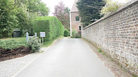
 google parking directions
Links
This region uses the Uk/Euro style trail grading system.
Activities Click to view
- Mountain Bike
3 trails
- E-Bike
3 trails
- Hike
1 trails
- Trail Running
1 trails
Region Details
- 1
- 1
- 1
Region Status
Open as of Jul 5, 2020Local Trail Association
Stats
- Avg Trail Rating
- Trails (view details)
- 3
- Trails Mountain Bike
- 3
- Trails E-Bike
- 3
- Trails Hike
- 1
- Trails Trail Running
- 1
- Total Distance
- 2,276 ft
- Total Descent
- 335 ft
- Total Vertical
- 129 ft
- Highest Trailhead
- 326 ft
- Reports
- 5
- Photos
- 3
- Ridden Counter
- 170
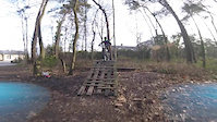
Popular Champles Mountain Biking Trails
• 45 ★ 4.5 • 715 ft • 4 ft • 66 •
This tracks is cool to ride whatever your skills... contains some jumps a "stepdown to transfer" feature, where you can go soo long if you let off the brakes ! It's about about 30s - 1minute long from top to bottom.
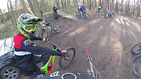
• 55 ★ 5.0 • 676 ft • 19 ft • 66 •
Built by Nico Vink and his crew, the is perfect for a hardtail- dirtjump bike or a slopestyle bike. It's jumpable with an enduro or a dh bike but it's hard to go as high on the jumps. Jumps are 'massive', one transfer, two step-downs...
• 50 ★ 5.0 • 886 ft • 10 ft • 62 •
The main track was one of the first track built in the wood. It's been evoluating since, jumps getting bigger etc... It's a pretty flowy line with some doubles, berms, and drops.
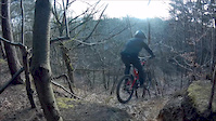
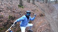
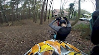
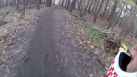
Videos of Champles Mountain Bike
trail: Vink line
0:42 |
264 |
Dec 19, 2018
trail: Vink line
0:32 |
240 |
Apr 28, 2018
trail: Vink line
0:41 |
644 |
Mar 15, 2018
trail: Vink line
2:35 |
267 |
Feb 19, 2018
trail: Vink line
0:59 |
63 |
Jan 11, 2018
trail: Vink line
0:39 |
753 |
Nov 29, 2015

trail: Vink line
0:00 |
136 |
Nov 29, 2015
trail: Piste principale
3:28 |
276 |
Jan 27, 2015
Recent Trail Reports
| status | trail | date | condition | info | user |
|---|---|---|---|---|---|
| Piste principale | Sep 21, 2019 @ 11:49pm Sep 21, 2019 | Dry | krislahaye | ||
| Vink line | Dec 9, 2018 @ 11:45pm Dec 9, 2018 | Variable | Jenstin TRAILFORKS | ||
| La piste tout à droite | Dec 9, 2018 @ 11:45pm Dec 9, 2018 | Variable | Jenstin TRAILFORKS |
Activity Feed
| username | action | type | title | date |
|---|---|---|---|---|
| Dvidg5NMDH | wishlist | trail | activity #75943974 | Jul 15, 2025 @ 4:09am Jul 15, 2025 |
| Leodobb | ridden | trail | activity #60221618 | Oct 9, 2024 @ 8:42am Oct 9, 2024 |
| DimitrilgwXNE | wishlist | trail | activity #45156643 | Oct 12, 2023 @ 2:07pm Oct 12, 2023 |
| Ramiro275 | ridden | trail | activity #36302724 and 1 more | Dec 29, 2022 @ 2:09am Dec 29, 2022 |
| Ramiro275 | wishlist | trail | activity #36301971 and 2 more | Dec 29, 2022 @ 12:24am Dec 29, 2022 |
Nearby Areas
| name | distance | ||||
|---|---|---|---|---|---|
| Malvina Wood | 3 | 3.8 km | |||
| Bois des Rêves | 2 | 14 | 5.1 km | ||
| Sterbike | 3 | 4 | 9.6 km | ||
| Bois de la Cambre - Ter Komerenbos | 5 | 9.6 km | |||
| Bertembos | 6 | 6 | 10.8 km |
Activity Type Stats
| activitytype | trails | distance | descent | descent distance | total vertical | rating | global rank | state rank | photos | reports | routes | ridelogs |
|---|---|---|---|---|---|---|---|---|---|---|---|---|
| Mountain Bike | 3 | 2,277 ft | 335 ft | 1,663 ft | 128 ft | #2,771 | #14 | 3 | 5 | 587 | ||
| E-Bike | 3 | 2,277 ft | 335 ft | 1,663 ft | 128 ft | #1,728 | #15 | 5 | 26 | |||
| Hike | 1 | 886 ft | 105 ft | 607 ft | 102 ft | #2,630 | #16 | 2 | 3 | |||
| Trail Running | 1 | 886 ft | 105 ft | 607 ft | 102 ft | #1,933 | #15 | 2 |
- By Jenstin
 TRAILFORKS & contributors
 - Admins: apply
- #24978 - 4,432 views
- champles activity log | embed map of Champles mountain bike trails | champles mountain biking points of interest
Downloading of trail gps tracks in kml & gpx formats is enabled for Champles.
You must login to download files.