close
-
Layers w
- Weather Layers
- Pro
- Pro
- Pro
- Pro
- Pro
- Pro
- More Layers
- Pro
- Pro
- Pro
- Pro
-
Upgrade to

3D
Trail Conditions
- Unknown
- Snow Groomed
- Snow Packed
- Snow Covered
- Snow Cover Partial
- Freeze/thaw Cycle
- Icy
- Prevalent Mud
- Wet
- Variable
- Ideal
- Dry
- Very Dry
Trail Flow (Ridden Direction)
Trailforks scans users ridelogs to determine the most popular direction each trail is ridden. A good flowing trail network will have most trails flowing in a single direction according to their intension.
The colour categories are based on what percentage of riders are riding a trail in its intended direction.
The colour categories are based on what percentage of riders are riding a trail in its intended direction.
- > 96%
- > 90%
- > 80%
- > 70%
- > 50%
- < 50%
- bi-directional trail
- no data
Trail Last Ridden
Trailforks scans ridelogs to determine the last time a trail was ridden.
- < 2 days
- < 1 week
- < 2 weeks
- < 1 month
- < 6 months
- > 6 months
Trail Ridden Direction
The intended direction a trail should be ridden.
- Downhill Only
- Downhill Primary
- Both Directions
- Uphill Primary
- Uphill Only
- One Direction
Contribute Details
Colors indicate trail is missing specified detail.
- Description
- Photos
- Description & Photos
- Videos
Trail Popularity ?
Trailforks scans ridelogs to determine which trails are ridden the most in the last 9 months.
Trails are compared with nearby trails in the same city region with a possible 25 colour shades.
Think of this as a heatmap, more rides = more kinetic energy = warmer colors.
- most popular
- popular
- less popular
- not popular
ATV/ORV/OHV Filter
Max Vehicle Width
inches
US Cell Coverage
Legend

Radar Time
Activity Recordings
Trailforks uses anonymized public activity data.
?
Activity Recordings
Trailforks uses anonymized public activity data.
?
Personal Heatmap
▶
Activity Types
all
/
none
▶
Options
2
Date range
month
–
Winter Trails
Warning
A routing network for winter maps does not exist. Selecting trails using the winter trails layer has been disabled.
Missing Trails
Most Popular
Least Popular
Trails are colored based on popularity. The more popular a trail is, the more red. Less popular trails trend towards green.
Jump Magnitude Heatmap
Heatmap of where riders jump on trails. Zoom in to see individual jumps, click circles to view jump details.
BC Backroad Status
![map legend]()
Service Road Atlas is a free to use, community-driven service for viewing and creating reports on the numerous back-country service roads around B.C. and Alberta.

Slope Aspect
Direction the slope faces
Trails Deemphasized
Trails are shown in grey.
Only show trails with no bike usage.
Suggested Layers
Based on selected activity type
Save the current map location and zoom level as your default home location whenever this page is loaded.
SaveTrails around Darlingerode. Irritational fact: Darlingerode belongs to Ilsenburg whereas the trail area belongs to Wernigerode, although it's nearer to Darlingerode
Primary Trail Type: All-Mountain & Downhill
eBikes Allowed:
No
AKA: Darlingeröder Schweiz
Access Info:
Parkplatz Schützenhaus Darlingerode
This region uses the Uk/Euro style trail grading system.
Activities Click to view
- Mountain Bike
6 trails
- E-Bike
6 trails
- Hike
6 trails
- Trail Running
6 trails
Region Details
- 4
- 1
Region Status
Caution as of May 17, 2026Stats
- Avg Trail Rating
- Trails (view details)
- 5
- Trails Mountain Bike
- 6
- Trails E-Bike
- 6
- Trails Hike
- 6
- Trails Trail Running
- 6
- Total Distance
- 2 miles
- Total Descent Distance
- 4,482 ft
- Total Descent
- 333 ft
- Total Vertical
- 1,240 ft
- Highest Trailhead
- 2,222 ft
- Reports
- 213
- Photos
- 15
- Ridden Counter
- 574
Popular Darlingerode Mountain Biking Trails
• 100 ★ 4.2 • 1,604 ft • 0 ft • 327 •
Highly rated popular blue difficulty singletrack. This mountain bike primary trail can be used downhill only. It features berm and jump. On average it takes 1 minutes to complete this trail.
• 60 ★ 2.4 • 1,972 ft • 0 ft • 7 •
Einfacher und leicht kurviger Trail, sehr schön zwischen alten Bäumen gelegen. Im Sommer etwas viel Bewuchs, ansonsten auch für Kinder zu empfehlen.
Photos of Darlingerode Mountain Bike
Videos of Darlingerode Mountain Bike
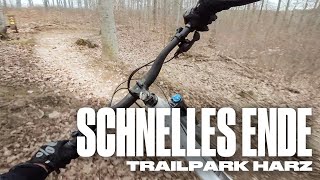
trail: Schnelles Ende
0:07 |
173 |
Apr 16, 2023 , Ilsenburg
Recent Trail Reports
| status | trail | date | condition | info | user |
|---|---|---|---|---|---|
| Schnelles Ende | May 17, 2026 @ 10:55am (Europe/Berlin) May 17, 2026 | Ideal | HBAMTB HBM | ||
| Zum Ütschenteich | Apr 6, 2026 @ 12:04pm (Europe/Berlin) Apr 6, 2026 | Ideal | tsurugi68 | ||
| Zum Sportplatz | Mar 11, 2026 @ 12:09am (Europe/Berlin) Mar 10, 2026 | Ideal | Einfach | ||
| Dachsklippen-Trail II | Dec 11, 2025 @ 6:41pm (Europe/Berlin) Dec 11, 2025 | Unknown | Einfach | ||
| Jägergrund | Sep 10, 2025 @ 12:49pm Sep 10, 2025 | Dry | Einfach |
Activity Feed
| username | action | type | title | date |
|---|---|---|---|---|
| HBAMTB | add | report | activity #94942854 | May 17, 2026 @ 2:55pm May 17, 2026 |
| CasperZ6UbOu | wishlist | trail | activity #94765073 | May 15, 2026 @ 1:13pm May 15, 2026 |
| Marci166 | ridden | trail | activity #93069383 | Apr 21, 2026 @ 3:16am Apr 21, 2026 |
| SjeambecK | vote | trail | activity #93035873 | Apr 20, 2026 @ 12:58pm Apr 20, 2026 |
| SjeambecK | add | report | activity #92885097 | Apr 18, 2026 @ 12:37pm Apr 18, 2026 |
Recent Comments
| username | type | title | comment | date |
|---|---|---|---|---|
| report | Der Trail ist dicht? | Jan 22, 2026 @ 2:31am Jan 22, 2026 | ||
| trail | Leider unfahrbar, Bäume im Weg | Apr 19, 2025 @ 8:48am Apr 19, 2025 | ||
| trail | Fahrbare | Apr 19, 2025 @ 8:46am Apr 19, 2025 | ||
| report | Hi. Wo genau findet man die beiden | Feb 9, 2025 @ 10:25pm Feb 9, 2025 | ||
| trail | Schrott. Überall Bäume umgefallen im Weg.... | Apr 27, 2024 @ 6:48am Apr 27, 2024 |
Nearby Areas
| name | distance | ||||
|---|---|---|---|---|---|
| Trailpark Harz | 1 | 1.4 km | |||
| Mountainbike-Areal Schmiedeberg | 2.2 km | ||||
| Ilsetal | 5 | 4 | 2.4 km | ||
| Brocken | 6 | 10 | 4.8 km | ||
| Wernigerode Ost | 12 | 6 | 4.9 km |
Activity Type Stats
| activitytype | trails | distance | descent | descent distance | total vertical | rating | global rank | state rank | photos | reports | routes | ridelogs |
|---|---|---|---|---|---|---|---|---|---|---|---|---|
| Mountain Bike | 6 | 2 miles | 335 ft | 4,482 ft | 1,240 ft | #7,966 | #110 | 15 | 213 | 1,642 | ||
| E-Bike | 6 | 2 miles | 335 ft | 4,482 ft | 1,240 ft | #4,100 | #84 | 199 | 343 | |||
| Hike | 6 | 2 miles | 335 ft | 4,482 ft | 1,240 ft | #6,584 | #76 | 213 | 10 | |||
| Trail Running | 6 | 2 miles | 335 ft | 4,482 ft | 1,240 ft | #5,724 | #72 | 213 | 2 |
- By effeffeff
 & contributors
 - Admins: apply
- #30063 - 5,407 views
- darlingerode activity log | embed map of Darlingerode mountain bike trails |
Downloading of trail gps tracks in kml & gpx formats is enabled for Darlingerode.
You must login to download files.