close
-
Layers w
- Weather Layers
- Pro
- Pro
- Pro
- Pro
- Pro
- Pro
- More Layers
- Pro
- Pro
- Pro
- Pro
-
Upgrade to

3D
Trail Conditions
- Unknown
- Snow Groomed
- Snow Packed
- Snow Covered
- Snow Cover Partial
- Freeze/thaw Cycle
- Icy
- Prevalent Mud
- Wet
- Variable
- Ideal
- Dry
- Very Dry
Trail Flow (Ridden Direction)
Trailforks scans users ridelogs to determine the most popular direction each trail is ridden. A good flowing trail network will have most trails flowing in a single direction according to their intension.
The colour categories are based on what percentage of riders are riding a trail in its intended direction.
The colour categories are based on what percentage of riders are riding a trail in its intended direction.
- > 96%
- > 90%
- > 80%
- > 70%
- > 50%
- < 50%
- bi-directional trail
- no data
Trail Last Ridden
Trailforks scans ridelogs to determine the last time a trail was ridden.
- < 2 days
- < 1 week
- < 2 weeks
- < 1 month
- < 6 months
- > 6 months
Trail Ridden Direction
The intended direction a trail should be ridden.
- Downhill Only
- Downhill Primary
- Both Directions
- Uphill Primary
- Uphill Only
- One Direction
Contribute Details
Colors indicate trail is missing specified detail.
- Description
- Photos
- Description & Photos
- Videos
Trail Popularity ?
Trailforks scans ridelogs to determine which trails are ridden the most in the last 9 months.
Trails are compared with nearby trails in the same city region with a possible 25 colour shades.
Think of this as a heatmap, more rides = more kinetic energy = warmer colors.
- most popular
- popular
- less popular
- not popular
ATV/ORV/OHV Filter
Max Vehicle Width
inches
US Cell Coverage
Legend

Radar Time
Activity Recordings
Trailforks uses anonymized public activity data.
?
Activity Recordings
Trailforks uses anonymized public activity data.
?
Personal Heatmap
▶
Activity Types
all
/
none
▶
Options
2
Date range
month
–
Winter Trails
Warning
A routing network for winter maps does not exist. Selecting trails using the winter trails layer has been disabled.
Missing Trails
Most Popular
Least Popular
Trails are colored based on popularity. The more popular a trail is, the more red. Less popular trails trend towards green.
Jump Magnitude Heatmap
Heatmap of where riders jump on trails. Zoom in to see individual jumps, click circles to view jump details.
BC Backroad Status
![map legend]()
Service Road Atlas is a free to use, community-driven service for viewing and creating reports on the numerous back-country service roads around B.C. and Alberta.

Slope Aspect
Direction the slope faces
Trails Deemphasized
Trails are shown in grey.
Only show trails with no bike usage.
Suggested Layers
Based on selected activity type
Save the current map location and zoom level as your default home location whenever this page is loaded.
Save
No description for Delnice has been added yet!
Login or register to submit one.
This region uses the Uk/Euro style trail grading system.
Activities Click to view
- Mountain Bike
5 trails
- E-Bike
5 trails
- Winter Fat Bike
0 trails
- Hike
4 trails
Region Details
- 2
- 3
Region Status
Open as of May 26, 2026Stats
- Avg Trail Rating
- Trails (view details)
- 5
- Trails Mountain Bike
- 5
- Trails E-Bike
- 5
- Trails Horse
- 2
- Trails Hike
- 4
- Trails Trail Running
- 2
- Trails Dirtbike/Moto
- 2
- Trails ATV/ORV/OHV
- 2
- Total Distance
- 6 miles
- Total Descent Distance
- 3 miles
- Total Descent
- 1,445 ft
- Total Vertical
- 682 ft
- Highest Trailhead
- 1,418 ft
- Reports
- 23
- Photos
- 16
- Ridden Counter
- 33
Sub Regions
-
Kupa Valley
- 3
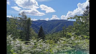
Popular Delnice Mountain Biking Trails
• 100 ★ 4.0 • 2,549 ft • 0 ft • 11 •
AM Trail is singletrack built back in 2014, the final shape of the trail is done in 2020. The encountering of wild animals is highly possible, bears, wild boars, deers, grey wolves. Day rides only. Could be slippery in the middle...
• 60 ★ 5.0 • 2,142 ft • 0 ft • 9 •
Singletrack, not for the beginners. Advanced riders only. No chicken available for the last drop. On foot inspection of the first drop (near the start) is recommended, due to erosion caused by forestry activities in 2020. Encountering...
• 40 ★ 5.0 • 1,312 ft • 0 ft • 8 •
Schrappnell is built in May 2021. It is a flowy trail but steep switchbacks, jumps, drops are not for beginners. Slippery when wet and loose to very loose in dry conditions. Please use tyres with more grip (3C). The encountering of wild...
Delnice Mountain Bike Routes
16 miles • 1,831 ft • 0 • Loop •
Delnice - Sović Laz - Lazac Lokvarski - Praprot - ispod Drgomlja - Delnice
9 miles • 1,366 ft • 1 • Loop •
Delnice - Polane - Štimčev vrh - Petehovac - Delnice
Photos of Delnice Mountain Bike
Videos of Delnice Mountain Bike

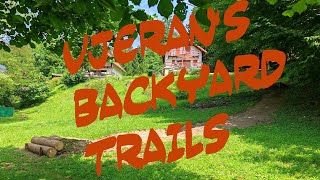
trail: AM Trail, part of BYT System
12:04 |
107 |
Aug 5, 2024 , Delnice
12:04 |
70 |
Aug 5, 2024 , Delnice

12:04 |
92 |
Aug 5, 2024 , Delnice

7:06 |
251 |
Oct 26, 2020 , Delnice
trail: AM Trail, part of BYT System
7:06 |
220 |
Oct 26, 2020 , Delnice
Recent Trail Reports
Activity Feed
| username | action | type | title | date |
|---|---|---|---|---|
| Teek-1 | add | report | activity #95613940 and 2 more | May 26, 2026 @ 10:12pm May 26, 2026 |
| davidc5 | comment | trail | activity #93345022 | Apr 25, 2026 @ 5:23am Apr 25, 2026 |
| davidc5 | ridden | trail | activity #93344620 | Apr 25, 2026 @ 5:16am Apr 25, 2026 |
| davidc5 | vote | trail | activity #93344608 | Apr 25, 2026 @ 5:15am Apr 25, 2026 |
| ante0abP3V | ridden | trail | activity #91426396 | Mar 28, 2026 @ 4:49am Mar 28, 2026 |
Recent Comments
| username | type | title | comment | date |
|---|---|---|---|---|
| trail | Needs to be cleaned to become enjoyable. Now... | Apr 25, 2026 @ 5:23am Apr 25, 2026 | ||
| trail | The trail is cleared and super-dry. | Jun 24, 2025 @ 3:48am Jun 24, 2025 | ||
| trail | The trail has been cleared and is super-dry. | Jun 23, 2025 @ 11:07pm Jun 23, 2025 | ||
| trail | Hero dirt today. | Apr 14, 2024 @ 6:09am Apr 14, 2024 | ||
| trail | Hero dirt today. | Apr 14, 2024 @ 6:08am Apr 14, 2024 |
Activity Type Stats
| activitytype | trails | distance | descent | descent distance | total vertical | rating | global rank | state rank | photos | reports | routes | ridelogs |
|---|---|---|---|---|---|---|---|---|---|---|---|---|
| Mountain Bike | 5 | 6 miles | 1,444 ft | 3 miles | 682 ft | #4,600 | #30 | 14 | 23 | 2 | 98 | |
| E-Bike | 5 | 6 miles | 1,444 ft | 3 miles | 682 ft | #4,622 | #36 | 23 | 185 | |||
| Horse | 2 | 5 miles | 157 ft | 2 miles | 682 ft | |||||||
| Hike | 4 | 6 miles | 1,047 ft | 2 miles | 682 ft | #8,165 | #51 | 20 | 16 | |||
| Trail Running | 2 | 5 miles | 157 ft | 2 miles | 682 ft | 15 | 5 | |||||
| Dirtbike/Moto | 2 | 5 miles | 157 ft | 2 miles | 682 ft | |||||||
| ATV/ORV/OHV | 2 | 5 miles | 157 ft | 2 miles | 682 ft | 2 |
- By Teek-1
 & contributors
 - Admins: apply
- #41128 - 1,178 views
- delnice activity log | embed map of Delnice mountain bike trails |
Downloading of trail gps tracks in kml & gpx formats is enabled for Delnice.
You must login to download files.