close
-
Layers w
- Weather Layers
- Pro
- Pro
- Pro
- Pro
- Pro
- Pro
- More Layers
- Pro
- Pro
- Pro
- Pro
-
Upgrade to

3D
Trail Conditions
- Unknown
- Snow Groomed
- Snow Packed
- Snow Covered
- Snow Cover Partial
- Freeze/thaw Cycle
- Icy
- Prevalent Mud
- Wet
- Variable
- Ideal
- Dry
- Very Dry
Trail Flow (Ridden Direction)
Trailforks scans users ridelogs to determine the most popular direction each trail is ridden. A good flowing trail network will have most trails flowing in a single direction according to their intension.
The colour categories are based on what percentage of riders are riding a trail in its intended direction.
The colour categories are based on what percentage of riders are riding a trail in its intended direction.
- > 96%
- > 90%
- > 80%
- > 70%
- > 50%
- < 50%
- bi-directional trail
- no data
Trail Last Ridden
Trailforks scans ridelogs to determine the last time a trail was ridden.
- < 2 days
- < 1 week
- < 2 weeks
- < 1 month
- < 6 months
- > 6 months
Trail Ridden Direction
The intended direction a trail should be ridden.
- Downhill Only
- Downhill Primary
- Both Directions
- Uphill Primary
- Uphill Only
- One Direction
Contribute Details
Colors indicate trail is missing specified detail.
- Description
- Photos
- Description & Photos
- Videos
Trail Popularity ?
Trailforks scans ridelogs to determine which trails are ridden the most in the last 9 months.
Trails are compared with nearby trails in the same city region with a possible 25 colour shades.
Think of this as a heatmap, more rides = more kinetic energy = warmer colors.
- most popular
- popular
- less popular
- not popular
ATV/ORV/OHV Filter
Max Vehicle Width
inches
US Cell Coverage
Legend

Radar Time
Activity Recordings
Trailforks uses anonymized public activity data.
?
Activity Recordings
Trailforks uses anonymized public activity data.
?
Personal Heatmap
▶
Activity Types
all
/
none
▶
Options
2
Date range
month
–
Winter Trails
Warning
A routing network for winter maps does not exist. Selecting trails using the winter trails layer has been disabled.
Missing Trails
Most Popular
Least Popular
Trails are colored based on popularity. The more popular a trail is, the more red. Less popular trails trend towards green.
Jump Magnitude Heatmap
Heatmap of where riders jump on trails. Zoom in to see individual jumps, click circles to view jump details.
BC Backroad Status
![map legend]()
Service Road Atlas is a free to use, community-driven service for viewing and creating reports on the numerous back-country service roads around B.C. and Alberta.

Slope Aspect
Direction the slope faces
Trails Deemphasized
Trails are shown in grey.
Only show trails with no bike usage.
Suggested Layers
Based on selected activity type
Save the current map location and zoom level as your default home location whenever this page is loaded.
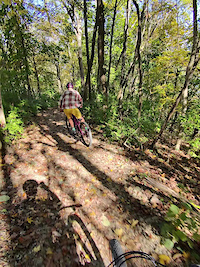
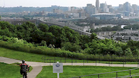
SaveLocated 15 minutes from downtown and 5 minutes from I-75. The trails are not just for bikes though, they are for all self propelled activities.
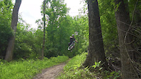
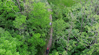
The project was hatched in 2004. After four years of approval process, ground broke in 2008. (Soo Nice!) As of 2024, 14 miles (and counting) have been constructed. Trails are a mix of flowy-pumpy-jumpy bmx-ish sweetness with some tight and twisties mixed in. Some rock features, albeit small in the grand scheme of rock features dot the system. A couple of 3/4+ mile, 200+ vertical foot descent/climbs can be found. The topography of Devou Park allows it to be home to some of the longest climbs/descents in the region. All trails but one are two way. Devou Park is quickly becoming a regional destination for self propelled activities. See you on the trails!
For more information visit https://www.exploredevoupark.org/back-trails
source: Devou Park Trails Website
Primary Trail Type: Cross-Country
eBikes Allowed:
Yes
AKA: Devou
Land Status: City Managed
Land Manager: City of Covington
 google parking directions
 Access Info:
The Large Gravel lot off of Sleepy Hollow while put you in the middle of it all with the most amount of parking. Other parking areas include but not limited too; The corner of Montague and Amsterdam, The bottom of Montague near the Sleepy Hollow Trail head and the Overlook at the top of the park. Montague road bisects the park and there is parking at either end. There is parking at the welcome center. There is a restaurant/bar, restrooms and a bike repair stand there. There are many other parking areas in the park. Too many to mention. I have mentioned the parking areas nearest the trailheads.
Links
Files
- DPTC_Logo.png (160 KB)
Activities Click to view
- Mountain Bike
41 trails
- E-Bike
29 trails
- Hike
39 trails
- Trail Running
39 trails
Stats
- Avg Trail Rating
- Trails (view details)
- 33
- Trails Mountain Bike
- 42
- Trails E-Bike
- 29
- Trails Hike
- 39
- Trails Trail Running
- 39
- Trails Snowshoe
- 1
- Trails Downhill Ski
- 1
- Trails Backcountry Ski
- 1
- Trails Nordic Ski
- 1
- Total Distance
- 12 miles
- Total Descent
- 2,433 ft
- Total Vertical
- 371 ft
- Highest Trailhead
- 857 ft
- Reports
- 714
- Photos
- 56
- Ridden Counter
- 7,150
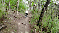
Popular Devou Park Mountain Biking Trails
• 100 ★ 4.8 • 1 mile • 290 ft • 465 •
The OG! So sweet!! Some upgrades at the beginning of bottom. Thanks!!
• 90 ★ 4.5 • 3,750 ft • 103 ft • 412 •
If you hit it at just the right time it will feel like you are surfing on top of a train
• 95 ★ 4.9 • 2 miles • 213 ft • 399 •
A few rock areas making it intermediate. A few quick drops with smallish jumps. Climbs are some what stout, not too hard though
• 90 ★ 5.0 • 4,984 ft • 89 ft • 359 •
The latest and greatest in trail design. (2014) Roller coaster goodness. Big jumps, but not too steep. We feel it is the perfect intermediate flow trail. Big and fast enough for the experts, but not too big preventing confidence and...
• 85 ★ 4.7 • 801 ft • 6 ft • 357 •
This trail was named after the dog of the designer of the Devou Park Trails. Pig (the dog) helped the designer layout all of the trials for the Devou Park Trail Expansion Project. He is sorely missed. This Trail is his tale. Trail is...
• 90 ★ 4.6 • 4,606 ft • 0 ft • 350 •
This trial was built with a grant to connect top of the park with the bottom of the park. Previously the only route was on a road. This is a two way multi-use trail that turned out really rad. It is a favorite among bikers. It is...
• 75 ★ 4.9 • 4,068 ft • 185 ft • 346 •
Traveling either direction on is an exhilarating experience. 1/2 of trail is flowy-bermy-pumpy-with a little jumpy and the other 1/2 is rack laden tech goodness.
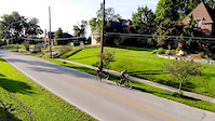
Devou Park Mountain Bike Routes
8 miles • 945 ft • 7 •
This is a ride from Mtbhaus to the park side at devou. Hits all the trails on that side of the park minus...
7 miles • 989 ft • 8 • Point to Point •
Route from checkin thru all of the five stages. L-Train, Full Monty, Back Bowl, Pigs Tail, & Devoution
7 miles • 974 ft • 7 •
This is a route of the devou park backcountry trails. Rides every trail. Skips a few sections.
Devou Frienduro 2023 Featured
★ 5.0 • 12 miles • 1,478 ft • 15 • Point to Point • Race •
Route for the Devou Frienduro 2023 including which is Sport and Expert only. Registration is open:...
9 miles • 1,275 ft • 13 • Loop • Race •
The official Course of the 2024 Devou Frienduro, presented by Hueber Homes!
5 miles • 648 ft • 3 • Loop • Race •
This is the official route for the 2025 Bluegrass Mountain Cup Devou XC on June 14th 2025. This route is...
Photos of Devou Park Mountain Bike
Videos of Devou Park Mountain Bike
0:38 |
5 |
Oct 29, 2025

0:03 |
520 |
Sep 29, 2019

trail: Full Monty
0:36 |
635 |
Sep 12, 2019
0:37 |
354 |
Jun 20, 2019
0:03 |
429 |
May 24, 2019
0:48 |
291 |
May 9, 2019
0:46 |
242 |
Oct 29, 2018
2:14 |
197 |
Oct 29, 2018
Recent Trail Reports
Activity Feed
| username | action | type | title | date |
|---|---|---|---|---|
| tallbikemitch | add | photo | activity #97503190 and 1 more | Jun 21, 2026 @ 11:11am 23 hours |
| gktrails | ridden | trail | activity #96586601 | Jun 8, 2026 @ 10:59pm Jun 8, 2026 |
| pnwmtbikes | add | report | activity #94279738 and 4 more | May 8, 2026 @ 3:13pm May 8, 2026 |
| 51ztgI | wishlist | trail | activity #93994789 and 1 more | May 3, 2026 @ 4:34pm May 3, 2026 |
| dmclindon | wishlist | trail | activity #93944182 | May 3, 2026 @ 7:17am May 3, 2026 |
Recent Comments
| username | type | title | comment | date |
|---|---|---|---|---|
| trail | Was running super well last week. Kudos to the... | Oct 29, 2025 @ 1:18pm Oct 29, 2025 | ||
| trail | New jumps on this trail are a godsend.... | Jun 1, 2025 @ 7:16pm Jun 1, 2025 | ||
| trail | Always one of my favorite tracks on the hill,... | Jun 1, 2025 @ 7:14pm Jun 1, 2025 | ||
| trail | This is my new favorite trail on the hill! Or... | Jun 1, 2025 @ 7:12pm Jun 1, 2025 | ||
| trail | Definitely lacking in the jump department for... | Jun 1, 2025 @ 7:11pm Jun 1, 2025 |
Nearby Areas
| name | distance | ||||
|---|---|---|---|---|---|
| Licking River Greenway | 1 | 2.6 km | |||
| Bellevue Beach Park | 4 km | ||||
| Sargeant Park | 4 | 4.8 km | |||
| Sargeant Park | 3 | 4.9 km | |||
| Highland Hills Park | 3 | 1 | 4.9 km |
Local Badges
-

Completionist3 awarded
Local Trail Supporters
- Devou Park Trail Collective
Activity Type Stats
| activitytype | trails | distance | descent | descent distance | total vertical | rating | global rank | state rank | photos | reports | routes | ridelogs |
|---|---|---|---|---|---|---|---|---|---|---|---|---|
| Mountain Bike | 41 | 12 miles | 2,434 ft | 7 miles | 371 ft | #1,825 | #612 | 56 | 714 | 6 | 7,959 | |
| E-Bike | 29 | 2 miles | 364 ft | 1 mile | 213 ft | #4,872 | #1,341 | 684 | 3 | 428 | ||
| Hike | 39 | 12 miles | 2,303 ft | 7 miles | 371 ft | #8,135 | #3,026 | 709 | 397 | |||
| Trail Running | 39 | 12 miles | 2,303 ft | 7 miles | 371 ft | #7,712 | #2,606 | 709 | 71 | |||
| Snowshoe | 1 | |||||||||||
| Downhill Ski | 1 | |||||||||||
| Backcountry Ski | 1 | |||||||||||
| Nordic Ski | 1 |
Frequently Asked Questions About Devou Park
▼
What are the highest rated mountain biking trails in Devou Park?
The highest rated mountain biking trails in Devou Park are:
- Bates-Coombs Loop (4.6/5)
- Sleepy Hollow Trail (4.5/5)
- Back Bowl (4.5/5)
- Trail of Devou-tion. (devotion) (4.4/5)
- Devil's Backbone (4.4/5)
▼
What is the best time of the year to ride in Devou Park?
Based on ride log data, the most popular months to ride in Devou Park are:
- June (81 activities)
- July (79 activities)
- August (79 activities)
▼
Where can I park to ride in Devou Park?
There are 6 parking locations listed in Devou Park. The most popular parking spots are:
- Deverill Street Parking Lot
- Parking
- Montague Road Upper Parking Lot
- Lewisburg Trailhead Parking Lot
- Parking
▼
What is the longest trail in Devou Park?
The longest trail in Devou Park is Bates-Coombs Loop at 2.0 miles. View all trails sorted by distance.
Activities
Trails
Points of Interest
- By antikid
 & contributors
 - Admins: DPTC
- #5776 - 42,196 views
- devou park activity log | embed map of Devou Park mountain bike trails | devou park mountain biking points of interest
Downloading of trail gps tracks in kml & gpx formats is enabled for Devou Park.
You must login to download files.