close
3D
Trail Conditions
- Unknown
- Snow Groomed
- Snow Packed
- Snow Covered
- Snow Cover Partial
- Freeze/thaw Cycle
- Icy
- Prevalent Mud
- Wet
- Variable
- Ideal
- Dry
- Very Dry
Trail Flow (Ridden Direction)
Trailforks scans users ridelogs to determine the most popular direction each trail is ridden. A good flowing trail network will have most trails flowing in a single direction according to their intension.
The colour categories are based on what percentage of riders are riding a trail in its intended direction.
The colour categories are based on what percentage of riders are riding a trail in its intended direction.
- > 96%
- > 90%
- > 80%
- > 70%
- > 50%
- < 50%
- bi-directional trail
- no data
Trail Last Ridden
Trailforks scans ridelogs to determine the last time a trail was ridden.
- < 2 days
- < 1 week
- < 2 weeks
- < 1 month
- < 6 months
- > 6 months
Trail Ridden Direction
The intended direction a trail should be ridden.
- Downhill Only
- Downhill Primary
- Both Directions
- Uphill Primary
- Uphill Only
- One Direction
Contribute Details
Colors indicate trail is missing specified detail.
- Description
- Photos
- Description & Photos
- Videos
Trail Popularity ?
Trailforks scans ridelogs to determine which trails are ridden the most in the last 9 months.
Trails are compared with nearby trails in the same city region with a possible 25 colour shades.
Think of this as a heatmap, more rides = more kinetic energy = warmer colors.
- most popular
- popular
- less popular
- not popular
ATV/ORV/OHV Filter
Max Vehicle Width
inches
US Cell Coverage
Legend
Radar Time
x
Activity Recordings
Trailforks users anonymized public ridelogs from the past 6 months.
- mountain biking recent
- mountain biking (>6 month)
- hiking (1 year)
- moto (1 year)
Activity Recordings
Trailforks users anonymized public skilogs from the past 12 months.
- Downhill Ski
- Backcountry Ski
- Nordic Ski
- Snowmobile
Winter Trails
Warning
A routing network for winter maps does not exist. Selecting trails using the winter trails layer has been disabled.
x
Missing Trails
Most Popular
Least Popular
Trails are colored based on popularity. The more popular a trail is, the more red. Less popular trails trend towards green.
Jump Magnitude Heatmap
Heatmap of where riders jump on trails. Zoom in to see individual jumps, click circles to view jump details.
Trails Deemphasized
Trails are shown in grey.
Only show trails with NO bikes.
Save the current map location and zoom level as your default home location whenever this page is loaded.
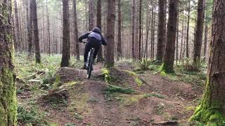
SaveThis trail network was called the "K2 trails" (because the K2 employees built most of them and whatever stunts have survived). The trails start at Dockton park, on Maury Island (Vashon and Maury connect at a narrow spit, "the portage", at the north end of Quartermaster Harbor. These trails have some grinding climbs and bombing DH runs. There is twisty tapewormish stuff in the gloomy 2nd growth woods, and some rolling singletrack through glades, a la Beaver lake.
From the North Ferry Dock (Vashon Heights):
Approximate distance: 14 miles.
Proceed south on Vashon Hwy SW past the town of Vashon.
The highway will jog to the right (west) and descend a hill
Turn left (east) on SW Quartermaster Drive.
Follow Quartermaster Dr. along the water until it stops at Dockton Rd. SW.
Stay on Dockton Rd. SW, shorly after the speed limit becomes 25 MPH, look for the parking areas and the boat ramp on the right side.
From the South Ferry Dock (Tahlequah):
Approximate distance: 14 miles.
Proceed North on Vashon Hwy SW past the town of Burton.
The highway will cross a concrete bridge;
Turn right (east) on SW Quartermaster Drive.
Follow Quartermaster Dr. along the water until it stops at Dockton Rd. SW.
Stay on Dockton Rd. SW, shorly after the speed limit becomes 25 MPH, look for the parking areas and the boat ramp on the right.
From the parking areas, the trails are all uphill. You will find a trail climbing out of the gravel parking area, you can ride east (and up) SW 260th St, and there is a trail on the east side of Dockton Rd SW, north of SW 260th st. Additionally, you will find multiple trails north and south as you ascend SW 260th St. I urge you to explore the variety of trails on both sides of SW 260th St. If you get lost, generally head downhill.
source: Evergreen: Dockton Forest
Primary Trail Type: All-Mountain & Downhill
eBikes Allowed:
Yes
AKA: Dockton Park
Land Status: City Managed
Links
Activities Click to view
- Mountain Bike
32 trails
- E-Bike
4 trails
- Horse
8 trails
- Hike
16 trails
- Trail Running
16 trails
Region Details
- 3
- 15
- 10
- 3
- 1
Region Status
Open as of May 2, 2024Stats
- Avg Trail Rating
- Trails (view details)
- 32
- Trails Mountain Bike
- 32
- Trails E-Bike
- 4
- Trails Horse
- 8
- Trails Hike
- 16
- Trails Trail Running
- 16
- Total Distance
- 7 miles
- Total Descent Distance
- 4 miles
- Total Descent
- 1,392 ft
- Total Vertical
- 328 ft
- Highest Trailhead
- 349 ft
- Reports
- 200
- Photos
- 6
- Ridden Counter
- 4,546
Popular Dockton Forest Mountain Biking Trails
Photos of Dockton Forest Mountain Bike
trail: Erratic
85 |
Jul 31, 2023 @ 10:29pm
Jul 31, 2023
trail: Access Trail
180 |
May 13, 2019 @ 8:07pm
May 13, 2019
trail: Access Trail
193 |
May 11, 2019 @ 1:29pm
May 11, 2019Videos of Dockton Forest Mountain Bike

trail: Flying Monkey
1:57 |
441 |
May 8, 2018

trail: A Climb
3:07 |
528 |
Jan 17, 2017

trail: Bumpy Monkey
0:48 |
213 |
Nov 9, 2022 , Vashon Island
Recent Trail Reports
| status | trail | date | condition | info | user |
|---|---|---|---|---|---|
| Flying Monkey | Jan 24, 2024 @ 2:51am Jan 24, 2024 | Ideal | marebearrr | ||
| Drag Race | Jan 24, 2024 @ 2:51am Jan 24, 2024 | Ideal | marebearrr | ||
| Mr. Hyde | Jan 24, 2024 @ 2:51am Jan 24, 2024 | Ideal | marebearrr | ||
| Chairlift | Jan 24, 2024 @ 2:51am Jan 24, 2024 | Ideal | marebearrr | ||
| Dr. Jekyll | Jan 24, 2024 @ 2:51am Jan 24, 2024 | Ideal | marebearrr | ||
| Feeder Line | Jan 24, 2024 @ 2:51am Jan 24, 2024 | Ideal | marebearrr | ||
| clearing access | Jan 24, 2024 @ 2:51am Jan 24, 2024 | Ideal | marebearrr | ||
| Erratic | Jan 24, 2024 @ 2:51am Jan 24, 2024 | Ideal | marebearrr | ||
| Gravel Grinder | Jan 24, 2024 @ 2:51am Jan 24, 2024 | Ideal | marebearrr | ||
| UFO | Jan 24, 2024 @ 2:51am Jan 24, 2024 | Ideal | marebearrr |
Activity Feed
| username | action | type | title | date |
|---|---|---|---|---|
| john-bur | ridden | trail | activity #51968551 | May 2, 2024 @ 12:47am May 2, 2024 |
| ritzy114 | vote | trail | activity #51234964 | Apr 15, 2024 @ 3:27pm Apr 15, 2024 |
| Mamadero | wishlist | trail | activity #50750058 | Apr 2, 2024 @ 5:36pm Apr 2, 2024 |
| capturecolorado | wishlist | trail | activity #50523199 | Mar 27, 2024 @ 5:20am Mar 27, 2024 |
| ritzy114 | vote | trail | activity #50393230 and 1 more | Mar 24, 2024 @ 3:59am Mar 24, 2024 |
Recent Comments
| username | type | title | comment | date |
|---|---|---|---|---|
| trail | Bigger gaps with a cool between the trees step... | Feb 11, 2024 @ 11:52pm Feb 11, 2024 | ||
| trail | Very nice line better to work through it with... | Feb 11, 2024 @ 11:50pm Feb 11, 2024 | ||
| trail | It's a big deal when the climb trail is just... | Jun 20, 2022 @ 7:51pm Jun 20, 2022 | ||
| trail | The berms on Erratic aren't quite as nice as... | Jun 20, 2022 @ 7:48pm Jun 20, 2022 | ||
| trail | UFO is an excellent beginner jump and flow... | Jun 20, 2022 @ 7:45pm Jun 20, 2022 |
Nearby Areas
| name | distance | ||||
|---|---|---|---|---|---|
| Maury Island Natural Area | 5 | 6 | 1 | 0.6 km | |
| Burton Acres | 3 | 1.3 km | |||
| Frog Holler | 6 | 2 | 2.4 km | ||
| Judd Creek Preserve | 3 | 3.2 km | |||
| Dash Point State Park | 16 | 11 | 4.5 km |
Local Badges
-

Completionist0 awarded
Local Products
Activity Type Stats
| activitytype | trails | distance | descent | descent distance | total vertical | rating | global rank | state rank | photos | reports | routes | ridelogs |
|---|---|---|---|---|---|---|---|---|---|---|---|---|
| Mountain Bike | 32 | 7 miles | 1,391 ft | 4 miles | 328 ft | #5,441 | #2,408 | 6 | 200 | 1,090 | ||
| E-Bike | 4 | 3,261 ft | 167 ft | 2,172 ft | 177 ft | #2,687 | 105 | 11 | ||||
| Horse | 8 | 2 miles | 269 ft | 3,770 ft | 328 ft | #571 | #397 | 32 | ||||
| Hike | 16 | 3 miles | 630 ft | 1 mile | 328 ft | #4,957 | #2,396 | 180 | 36 | |||
| Trail Running | 16 | 3 miles | 630 ft | 1 mile | 328 ft | #4,979 | #2,403 | 180 | 21 |
- By jmahler
 TRAILFORKS & contributors
 - Admins: VMBA, EMBA-C2S
- #16503 - 11,701 views
- dockton forest activity log | embed map of Dockton Forest mountain bike trails | dockton forest mountain biking points of interest
Downloading of trail gps tracks in kml & gpx formats is enabled for Dockton Forest.
You must login to download files.


