close
-
Layers w
- Weather Layers
- Pro
- Pro
- Pro
- Pro
- Pro
- Pro
- More Layers
- Pro
- Pro
- Pro
- Pro
-
Upgrade to

3D
Trail Conditions
- Unknown
- Snow Groomed
- Snow Packed
- Snow Covered
- Snow Cover Partial
- Freeze/thaw Cycle
- Icy
- Prevalent Mud
- Wet
- Variable
- Ideal
- Dry
- Very Dry
Trail Flow (Ridden Direction)
Trailforks scans users ridelogs to determine the most popular direction each trail is ridden. A good flowing trail network will have most trails flowing in a single direction according to their intension.
The colour categories are based on what percentage of riders are riding a trail in its intended direction.
The colour categories are based on what percentage of riders are riding a trail in its intended direction.
- > 96%
- > 90%
- > 80%
- > 70%
- > 50%
- < 50%
- bi-directional trail
- no data
Trail Last Ridden
Trailforks scans ridelogs to determine the last time a trail was ridden.
- < 2 days
- < 1 week
- < 2 weeks
- < 1 month
- < 6 months
- > 6 months
Trail Ridden Direction
The intended direction a trail should be ridden.
- Downhill Only
- Downhill Primary
- Both Directions
- Uphill Primary
- Uphill Only
- One Direction
Contribute Details
Colors indicate trail is missing specified detail.
- Description
- Photos
- Description & Photos
- Videos
Trail Popularity ?
Trailforks scans ridelogs to determine which trails are ridden the most in the last 9 months.
Trails are compared with nearby trails in the same city region with a possible 25 colour shades.
Think of this as a heatmap, more rides = more kinetic energy = warmer colors.
- most popular
- popular
- less popular
- not popular
ATV/ORV/OHV Filter
Max Vehicle Width
inches
US Cell Coverage
Legend

Radar Time
Activity Recordings
Trailforks uses anonymized public activity data.
?
Activity Recordings
Trailforks uses anonymized public activity data.
?
Personal Heatmap
▶
Activity Types
all
/
none
▶
Options
2
Date range
month
–
Winter Trails
Warning
A routing network for winter maps does not exist. Selecting trails using the winter trails layer has been disabled.
Missing Trails
Most Popular
Least Popular
Trails are colored based on popularity. The more popular a trail is, the more red. Less popular trails trend towards green.
Jump Magnitude Heatmap
Heatmap of where riders jump on trails. Zoom in to see individual jumps, click circles to view jump details.
BC Backroad Status
![map legend]()
Service Road Atlas is a free to use, community-driven service for viewing and creating reports on the numerous back-country service roads around B.C. and Alberta.

Slope Aspect
Direction the slope faces
Trails Deemphasized
Trails are shown in grey.
Only show trails with no bike usage.
Suggested Layers
Based on selected activity type
Save the current map location and zoom level as your default home location whenever this page is loaded.
Save
No description for Drammen has been added yet!
Login or register to submit one.
This region uses the Uk/Euro style trail grading system.
Activities Click to view
- Mountain Bike
125 trails
- Hike
114 trails
- Trail Running
114 trails
Region Details
- 69
- 1
- 48
- 25
- 1
Region Status
Open as of Dec 29, 2025Local Trail Association
Stats
- Avg Trail Rating
- Trails (view details)
- 153
- Trails Mountain Bike
- 125
- Trails E-Bike
- 8
- Trails Hike
- 114
- Trails Trail Running
- 114
- Trails Backcountry Ski
- 1
- Trails Nordic Ski
- 120
- Total Distance
- 40 miles
- Total Descent
- 12,716 ft
- Total Vertical
- 1,752 ft
- Highest Trailhead
- 1,814 ft
- Reports
- 27
- Photos
- 41
- Ridden Counter
- 688
Sub Regions
-
Drammen Skisenter
- 5
- 8
Popular Drammen Mountain Biking Trails
• 100 ★ 2.8 • 1 mile • 0 ft • 188 •
Maskinbygd utforløype med middels store hopp og drop. Ferdighetsnivå – Blå - Nybegynner til middels
• 90 ★ 0.0 • 5,184 ft • 0 ft • 82 •
Naturlig flytløype med teknisk bratte og krevende partier. Flere bygde elementer. Ferdighetsnivå – Rød - Erfaren syklist med god kontroll på hopp og bratte partier.
• 35 ★ 0.0 • 4,255 ft • 0 ft • 54 •
Less popular red difficulty singletrack. This mountain bike primary trail can be used downhill primary and has a hard overall physical rating with a 0 ft double black diamond climb. It features rock garden. Trail visibility is always easy to follow. On average it takes 9 minutes to complete this trail.
• 65 ★ 0.0 • 2,625 ft • 0 ft • 52 •
Moderately popular red difficulty singletrack. This mountain bike primary trail can be used downhill primary and has a moderate overall physical rating with a 0 ft black diamond climb. It features bridge, rock face and rock garden. Trail visibility is always easy to follow. On average it takes 5 minutes to complete this trail.
• 80 ★ 0.0 • 1 mile • 0 ft • 51 •
Popular red difficulty singletrack. This mountain bike primary trail can be used downhill primary and has a extreme overall physical rating with a 0 ft black diamond climb. It features rock face, rock garden and other. Trail visibility is sometimes hard to follow. On average it takes 13 minutes to complete this trail.
• 45 ★ 4.0 • 2 miles • 0 ft • 44 •
Classic all mountain dh track in Drammen. pedally with alot of rock slabs. Be aware of the bridges after the clear cut at the end of Børresens flyt.
• 60 ★ 0.0 • 1 mile • 0 ft • 43 •
Moderately popular red difficulty singletrack. This mountain bike primary trail can be used downhill primary with a 0 ft black diamond climb. It features berm, drop, gap jump, ladder bridge, rock face, rock garden and other. Trail visibility is sometimes hard to follow. On average it takes 6 minutes to complete this trail.
• 75 ★ 0.0 • 1 mile • 0 ft • 40 •
Popular red difficulty singletrack. This mountain bike primary trail can be used downhill only and has a hard overall physical rating with a 0 ft black diamond climb. It features berm, bridge, jump and rock face. Trail visibility is always easy to follow. On average it takes 7 minutes to complete this trail.
Drammen Mountain Bike Routes
29 miles • 2,639 ft • 0 •
Easy to follow Gravel/dirt roads. Steep to begin with and a fair bit of uphill work. Long decent on gravel...
19 miles • 3,861 ft • 0 • Loop • Race •
Rittet arrangeres som et endags etappe-enduroritt etter regler og rittprofil inspirert etter den tidligere...
6 miles • 1,075 ft • 0 • Race •
Ved ankomst i Drammen skisenter må dere følge instruksjoner fra parkeringsvakt og fylle opp innerste...
19 miles • 3,876 ft • 3 • Loop • Race •
Klasseinndelingen gjelder fra det året man fyller oppgitt nedre alder og det er ikke tillatt å melde seg...
10 miles • 1,408 ft • 0 • Race •
Ved ankomst i Drammen skisenter må dere følge instruksjoner fra parkeringsvakt og fylle opp innerste...
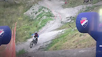
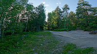
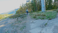
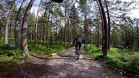
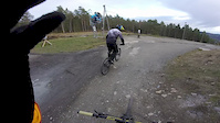
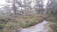
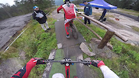
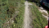
Photos of Drammen Mountain Bike
Videos of Drammen Mountain Bike
trail: NM 2020
0:06 |
35 |
Aug 11, 2025
trail: Glabakk + Børresens flyt
0:15 |
|
Jun 24, 2021
trail: 113
0:37 |
62 |
Jul 14, 2020
trail: Nc-løypa
2:54 |
126 |
Aug 17, 2019
trail: 113
5:23 |
9 |
Dec 12, 2018
trail: Skyttebanen
0:40 |
12 |
Sep 14, 2016
trail: Nc-løypa
3:38 |
634 |
Sep 13, 2015
trail: Flyt-løypa
0:10 |
655 |
Aug 8, 2015
Recent Trail Reports
| status | trail | date | condition | info | user |
|---|---|---|---|---|---|
| Flyt-løypa | Aug 13, 2025 @ 5:13pm Aug 13, 2025 | Ideal | Kjetilfp | ||
| Sagstykket Flyt | Jul 27, 2025 @ 1:26pm Jul 27, 2025 | Ideal | Kjetilfp | ||
| Baronens Allé | Jul 27, 2025 @ 1:26pm Jul 27, 2025 | Ideal | Kjetilfp | ||
| Blektjern Flyt | Jul 27, 2025 @ 1:26pm Jul 27, 2025 | Ideal | Kjetilfp | ||
| Juvet | Aug 12, 2023 @ 3:21am Aug 12, 2023 | Variable | enforce | ||
| TBE | Aug 12, 2023 @ 3:21am Aug 12, 2023 | Variable | enforce | ||
| Til venstre | Aug 12, 2023 @ 3:21am Aug 12, 2023 | Wet | enforce | ||
| Syrefest | Aug 12, 2023 @ 3:21am Aug 12, 2023 | Wet | enforce | ||
| 113 | Aug 12, 2023 @ 3:21am Aug 12, 2023 | Wet | enforce | ||
| Hennings | Aug 12, 2023 @ 3:21am Aug 12, 2023 | Variable | enforce |
Activity Feed
| username | action | type | title | date |
|---|---|---|---|---|
| Cykeljohan | add | trail | activity #97087503 and 12 more | Jun 15, 2026 @ 9:56pm Jun 15, 2026 |
| Cykeljohan | add | trail | activity #97033475 and 10 more | Jun 15, 2026 @ 5:02am Jun 15, 2026 |
| Cailloux | wishlist | trail | activity #95617739 | May 27, 2026 @ 12:28am May 27, 2026 |
| MartinPA75DG0 | ridden | trail | activity #94085466 | May 5, 2026 @ 6:17am May 5, 2026 |
| Cykeljohan | update | region | activity #92122242 | Apr 7, 2026 @ 9:11am Apr 7, 2026 |
Recent Comments
| username | type | title | comment | date |
|---|---|---|---|---|
| trail | Teilweise sehr schwierig den Trail zu finden,... | Aug 17, 2025 @ 8:29am Aug 17, 2025 | ||
| trail | Only 5* is the nature. 60% Mud 30% Push 10% Trail. | Jul 4, 2025 @ 1:20pm Jul 4, 2025 | ||
| trail | Great natural trail. Keep an eye open for... | Jul 25, 2024 @ 9:11am Jul 25, 2024 | ||
| trail | From the chairlift it is quite a long section... | Oct 16, 2023 @ 12:03am Oct 16, 2023 | ||
| trail | Nice flowy trail with small jumps. The upper... | Oct 16, 2023 @ 12:00am Oct 16, 2023 |
Local Badges
-

Epic Ride Climb 2k48 awarded -

Climbing 10k Badge18 awarded -

Climbing 100k Badge0 awarded -

Epic Ride Descent 2k62 awarded -

Descent 10k Badge20 awarded -

Descent 100k Badge0 awarded
Bike & Skill Parks
| name | type | city | rating |
|---|---|---|---|
| Drammen Skisenter | bike park | Drammen | |
| Nøstedhallen | skill park | Drammen |
Activity Type Stats
| activitytype | trails | distance | descent | descent distance | total vertical | rating | global rank | state rank | photos | reports | routes | ridelogs |
|---|---|---|---|---|---|---|---|---|---|---|---|---|
| Mountain Bike | 125 | 40 miles | 12,717 ft | 25 miles | 1,752 ft | #1,567 | #20 | 41 | 27 | 2 | 3,354 | |
| E-Bike | 8 | 4 miles | 2,162 ft | 3 miles | 856 ft | #1,860 | #26 | 27 | 1 | 700 | ||
| Hike | 114 | 30 miles | 6,001 ft | 15 miles | 1,752 ft | #1,751 | #25 | 27 | 401 | |||
| Trail Running | 114 | 30 miles | 6,001 ft | 15 miles | 1,752 ft | #1,328 | #23 | 27 | 36 | |||
| Backcountry Ski | 1 | 21 | ||||||||||
| Nordic Ski | 120 | #168 | #14 | 171 |
Frequently Asked Questions About Drammen
▼
What are the highest rated mountain biking trails in Drammen?
The highest rated mountain biking trails in Drammen are:
- Brennevinstien S, Bertelsmyråsen (4.1/5)
- Landfalltjern - Tverråsen - Goliaten (4.1/5)
- Glabakk + Børresens flyt (4/5)
- Breimåsan -east dh (3.9/5)
- Flyt-løypa (3.5/5)
▼
What is the best time of the year to ride in Drammen?
Based on ride log data, the most popular months to ride in Drammen are:
- July (5 activities)
- June (5 activities)
- May (2 activities)
▼
Where can I park to ride in Drammen?
There are 3 parking locations listed in Drammen. The most popular parking spots are: View all parking and trailhead locations on the map to plan your visit.
▼
What is the longest trail in Drammen?
The longest trail in Drammen is Tverråsvannet at 3.9 miles. View all trails sorted by distance.
Trails
- By brenthillier
 NSMBA TRAILFORKS & contributors
 - Admins: mtbboy1993, Cykeljohan
- #9303 - 6,045 views
- drammen activity log | embed map of Drammen mountain bike trails | drammen mountain biking points of interest
Downloading of trail gps tracks in kml & gpx formats is enabled for Drammen.
You must login to download files.