close
-
Layers w
- Weather Layers
- Pro
- Pro
- Pro
- Pro
- Pro
- Pro
- More Layers
- Pro
- Pro
- Pro
- Pro
-
Upgrade to

3D
Trail Conditions
- Unknown
- Snow Groomed
- Snow Packed
- Snow Covered
- Snow Cover Partial
- Freeze/thaw Cycle
- Icy
- Prevalent Mud
- Wet
- Variable
- Ideal
- Dry
- Very Dry
Trail Flow (Ridden Direction)
Trailforks scans users ridelogs to determine the most popular direction each trail is ridden. A good flowing trail network will have most trails flowing in a single direction according to their intension.
The colour categories are based on what percentage of riders are riding a trail in its intended direction.
The colour categories are based on what percentage of riders are riding a trail in its intended direction.
- > 96%
- > 90%
- > 80%
- > 70%
- > 50%
- < 50%
- bi-directional trail
- no data
Trail Last Ridden
Trailforks scans ridelogs to determine the last time a trail was ridden.
- < 2 days
- < 1 week
- < 2 weeks
- < 1 month
- < 6 months
- > 6 months
Trail Ridden Direction
The intended direction a trail should be ridden.
- Downhill Only
- Downhill Primary
- Both Directions
- Uphill Primary
- Uphill Only
- One Direction
Contribute Details
Colors indicate trail is missing specified detail.
- Description
- Photos
- Description & Photos
- Videos
Trail Popularity ?
Trailforks scans ridelogs to determine which trails are ridden the most in the last 9 months.
Trails are compared with nearby trails in the same city region with a possible 25 colour shades.
Think of this as a heatmap, more rides = more kinetic energy = warmer colors.
- most popular
- popular
- less popular
- not popular
ATV/ORV/OHV Filter
Max Vehicle Width
inches
US Cell Coverage
Legend

Radar Time
Activity Recordings
Trailforks uses anonymized public activity data.
?
Activity Recordings
Trailforks uses anonymized public activity data.
?
Personal Heatmap
▶
Activity Types
all
/
none
▶
Options
2
Date range
month
–
Winter Trails
Warning
A routing network for winter maps does not exist. Selecting trails using the winter trails layer has been disabled.
Missing Trails
Most Popular
Least Popular
Trails are colored based on popularity. The more popular a trail is, the more red. Less popular trails trend towards green.
Jump Magnitude Heatmap
Heatmap of where riders jump on trails. Zoom in to see individual jumps, click circles to view jump details.
BC Backroad Status
![map legend]()
Service Road Atlas is a free to use, community-driven service for viewing and creating reports on the numerous back-country service roads around B.C. and Alberta.

Slope Aspect
Direction the slope faces
Trails Deemphasized
Trails are shown in grey.
Only show trails with no bike usage.
Suggested Layers
Based on selected activity type
Save the current map location and zoom level as your default home location whenever this page is loaded.
Save
No description for Ebro has been added yet!
Login or register to submit one.
Activities Click to view
- Mountain Bike
12 trails
- Gravel Bike
0 trails
- Adaptive Bike
0 trails
- Hike
12 trails
- Trail Running
12 trails
Region Details
- 7
- 4
- 1
Region Status
Caution as of Nov 9, 2025Stats
- Avg Trail Rating
- Trails (view details)
- 12
- Trails Mountain Bike
- 12
- Trails Hike
- 12
- Trails Trail Running
- 12
- Total Distance
- 27 miles
- Total Descent
- 567 ft
- Total Vertical
- 88 ft
- Highest Trailhead
- 98 ft
- Reports
- 21
- Photos
- 42
- Ridden Counter
- 153
Sub Regions
-
Pine Log State Forest
- 3
- 1
Popular Ebro Mountain Biking Trails
• 100 ★ 0.0 • 9 miles • 247 ft • 58 •
A fun 10 mile flat loop trail. 98% single track. Trail tread description: loose over hard pack with short sandy sections. There are brown wood post with yellow mile markers. There are several forest road crossings. There should be a red...
• 95 ★ 3.4 • 6 miles • 181 ft • 47 •
Popular blue difficulty singletrack. This mountain bike primary trail can be used both directions. On average it takes 36 minutes to complete this trail.
• 75 ★ 0.0 • 2,218 ft • 2 ft • 19 •
Popular green difficulty singletrack. This mountain bike primary trail can be used both directions. On average it takes 1 minutes to complete this trail.
• 50 ★ 0.0 • 2,497 ft • 4 ft • 5 •
Moderately popular green difficulty singletrack. This mountain bike primary trail can be used both directions. On average it takes 8 minutes to complete this trail.
• 5 ★ 0.0 • 2,784 ft • 14 ft • 2 •
Less popular green difficulty singletrack. This mountain bike primary trail can be used both directions.
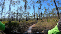
Photos of Ebro Mountain Bike
Videos of Ebro Mountain Bike
0:40 |
11 |
Feb 8, 2026
Recent Trail Reports
| status | trail | date | condition | info | user |
|---|---|---|---|---|---|
| Faye And Dutch | Nov 9, 2025 @ 2:51pm (America/Kentucky/Monticello) Nov 9, 2025 | Ideal | Edgeblade | ||
| Crooked Creek at Pine Log State Forest | Feb 26, 2023 @ 6:13am Feb 26, 2023 | Dry | csroberts100aLVOid | ||
| Crooked Creek Short | Jan 29, 2023 @ 6:11pm Jan 29, 2023 | Dry | Radroll100 |
Activity Feed
| username | action | type | title | date |
|---|---|---|---|---|
| Papacharlie2 | wishlist | trail | activity #89150778 | Feb 18, 2026 @ 4:13pm Feb 18, 2026 |
| Papacharlie2 | wishlist | trail | activity #89150724 | Feb 18, 2026 @ 4:12pm Feb 18, 2026 |
| Edgeblade | add | report | activity #83908321 | Nov 10, 2025 @ 4:59am Nov 10, 2025 |
| MichielBoldor | wishlist | trail | activity #80395587 | Sep 15, 2025 @ 4:28am Sep 15, 2025 |
| MesaMaye | ridden | trail | activity #80384700 | Sep 14, 2025 @ 7:53pm Sep 14, 2025 |
Recent Comments
| username | type | title | comment | date |
|---|---|---|---|---|
| trail | Agreed its super easy and could be green. I... | Feb 18, 2025 @ 5:02pm Feb 18, 2025 | ||
| trail | Trail in good condition | Jan 29, 2023 @ 6:10pm Jan 29, 2023 | ||
| trail | Trail was better than I expected.... | Feb 13, 2022 @ 1:58pm Feb 13, 2022 | ||
| trail | meh. If you have nothing else to ride and... | Sep 27, 2021 @ 7:07pm Sep 27, 2021 | ||
| trail | I parked at the location that says "Parking". ... | Sep 27, 2021 @ 7:04pm Sep 27, 2021 |
Local Badges
-

Epic Ride Climb 2k0 awarded -

Climbing 10k Badge0 awarded -

Climbing 100k Badge0 awarded -

Epic Ride Descent 2k0 awarded -

Descent 10k Badge0 awarded -

Descent 100k Badge0 awarded
Activity Type Stats
| activitytype | trails | distance | descent | descent distance | total vertical | rating | global rank | state rank | photos | reports | routes | ridelogs |
|---|---|---|---|---|---|---|---|---|---|---|---|---|
| Mountain Bike | 12 | 27 miles | 568 ft | 7 miles | 89 ft | #7,090 | #2,364 | 46 | 21 | 455 | ||
| Hike | 12 | 27 miles | 568 ft | 7 miles | 89 ft | #8,237 | #2,901 | 21 | 15 | |||
| Trail Running | 12 | 27 miles | 568 ft | 7 miles | 89 ft | #7,714 | #2,559 | 20 | 4 |
Frequently Asked Questions About Ebro
▼
What are the best places to ride in Ebro?
Ebro has 1 areas to explore for mountain biking. The top rated areas are:
▼
What are the highest rated mountain biking trails in Ebro?
The highest rated mountain biking trails in Ebro are:
- Faye And Dutch (3.7/5)
- Crooked Creek at Pine Log State Forest (0/5)
- Crooked Creek Short (0/5)
- Pine Log Campground (0/5)
- Pine Log Campground (0/5)
▼
What is the best time of the year to ride in Ebro?
Based on ride log data, the most popular months to ride in Ebro are:
- June (8 activities)
- May (7 activities)
- February (6 activities)
▼
Where can I park to ride in Ebro?
Check the Ebro trail map for trailhead and parking information. Community members regularly update access and parking details for trails in the area.
- By 01mntbikechamp & contributors
- Admins: apply
- #24026 - 1,142 views
- ebro activity log | embed map of Ebro mountain bike trails |
Downloading of trail gps tracks in kml & gpx formats is enabled for Ebro.
You must login to download files.