close
-
Layers w
- Weather Layers
- Pro
- Pro
- Pro
- Pro
- Pro
- Pro
- More Layers
- Pro
- Pro
- Pro
- Pro
-
Upgrade to

3D
Trail Conditions
- Unknown
- Snow Groomed
- Snow Packed
- Snow Covered
- Snow Cover Partial
- Freeze/thaw Cycle
- Icy
- Prevalent Mud
- Wet
- Variable
- Ideal
- Dry
- Very Dry
Trail Flow (Ridden Direction)
Trailforks scans users ridelogs to determine the most popular direction each trail is ridden. A good flowing trail network will have most trails flowing in a single direction according to their intension.
The colour categories are based on what percentage of riders are riding a trail in its intended direction.
The colour categories are based on what percentage of riders are riding a trail in its intended direction.
- > 96%
- > 90%
- > 80%
- > 70%
- > 50%
- < 50%
- bi-directional trail
- no data
Trail Last Ridden
Trailforks scans ridelogs to determine the last time a trail was ridden.
- < 2 days
- < 1 week
- < 2 weeks
- < 1 month
- < 6 months
- > 6 months
Trail Ridden Direction
The intended direction a trail should be ridden.
- Downhill Only
- Downhill Primary
- Both Directions
- Uphill Primary
- Uphill Only
- One Direction
Contribute Details
Colors indicate trail is missing specified detail.
- Description
- Photos
- Description & Photos
- Videos
Trail Popularity ?
Trailforks scans ridelogs to determine which trails are ridden the most in the last 9 months.
Trails are compared with nearby trails in the same city region with a possible 25 colour shades.
Think of this as a heatmap, more rides = more kinetic energy = warmer colors.
- most popular
- popular
- less popular
- not popular
ATV/ORV/OHV Filter
Max Vehicle Width
inches
US Cell Coverage
Legend

Radar Time
Activity Recordings
Trailforks uses anonymized public activity data.
?
Activity Recordings
Trailforks uses anonymized public activity data.
?
Personal Heatmap
▶
Activity Types
all
/
none
▶
Options
2
Date range
month
–
Winter Trails
Warning
A routing network for winter maps does not exist. Selecting trails using the winter trails layer has been disabled.
Missing Trails
Most Popular
Least Popular
Trails are colored based on popularity. The more popular a trail is, the more red. Less popular trails trend towards green.
Jump Magnitude Heatmap
Heatmap of where riders jump on trails. Zoom in to see individual jumps, click circles to view jump details.
BC Backroad Status
![map legend]()
Service Road Atlas is a free to use, community-driven service for viewing and creating reports on the numerous back-country service roads around B.C. and Alberta.

Slope Aspect
Direction the slope faces
Trails Deemphasized
Trails are shown in grey.
Only show trails with no bike usage.
Suggested Layers
Based on selected activity type
Save the current map location and zoom level as your default home location whenever this page is loaded.
Save400 kilometres of mountainbiking bliss: the well-signed Engadin bike routes show you the way. Anyone seeking the most spectacular ascent, the most stunning panorama or the most beautiful trail can profit from the insider knowledge of the local experts and fortunately in the Engadin there are plenty of them, offering professionally organised tours for all abilities. What's more, special mountainbike hotels provide a fitting framework by offering extra infrastructure and services. The mountain transport facilities take bikers to sporting heights – and open up new dimensions for the really ambitious.
source: ...
Primary Trail Type: All-Mountain & Downhill
Shuttleable: YES
Land Status: Ski Resort
Links
This region uses the Uk/Euro style trail grading system.
Activities Click to view
- Mountain Bike
83 trails
- E-Bike
83 trails
- Hike
75 trails
- Trail Running
80 trails
Region Details
- 20
- 17
- 17
- 19
- 2
Region Status
Open as of May 24, 2026Stats
- Avg Trail Rating
- Trails (view details)
- 76
- Trails Mountain Bike
- 84
- Trails E-Bike
- 83
- Trails Hike
- 80
- Trails Trail Running
- 80
- Total Distance
- 75 miles
- Total Descent Distance
- 41 miles
- Total Descent
- 25,036 ft
- Total Vertical
- 4,299 ft
- Highest Trailhead
- 9,901 ft
- Reports
- 956
- Photos
- 372
- Ridden Counter
- 12,116
Popular Engadin Mountain Biking Trails
• 100 ★ 4.2 • 5,200 ft • 2 ft • 885 •
Completely machine groomed. The evolution of the Corviglia Flow Trail. It has two wallrides and two drops built in - chickenways exist. The trail feels like it never ends though it's a short one. But you can easily ride back to the top.
• 100 ★ 4.4 • 3 miles • 119 ft • 748 •
First artificial trail at the site. Co-designed by Shane Wilson. Engadin St. Moritz’s on Corviglia follows the historic 1948 Olympic slope, offering mountain bikers a dynamic downhill pump-track experience. Spanning from Corviglia...
• 95 ★ 3.6 • 2 miles • 90 ft • 584 •
Der führt grösstenteils entlang der legendären Rennpiste, auf welcher seit 1974 drei Ski-Weltmeisterschaften ausgetragen wurden, und gehört somit zum geschichtsträchtigen und für jedermann befahrbaren Boden auf Corviglia. Diese...
• 95 ★ 4.4 • 719 ft • 0 ft • 429 •
Popular blue difficulty alpine singletrack. This multi-use trail can be used downhill primary and has a easy overall physical rating with a 0 ft green climb. Trail visibility is always easy to follow. On average it takes minutes to complete this trail.
• 70 ★ 4.5 • 3 miles • 22 ft • 419 •
Beautiful valley, watch out for 'stone path' that lead you over puddles; they can cause flat tires no mobile phone reception for a part of this trail
• 70 ★ 4.7 • 2 miles • 4 ft • 344 •
Very scenic trail. When you get to the top of , it's a short ride down a graveled road. Than you have a wonderful long and scenic single track. There are some hikers, so be friendly =). At the beginning it's steep, but not so trick....
• 85 ★ 4.2 • 4,088 ft • 0 ft • 304 •
Highly rated popular red difficulty alpine singletrack. This multi-use trail can be used downhill only and has a moderate overall physical rating. It features rock garden. Trail visibility is always easy to follow. On average it takes 5 minutes to complete this trail.
• 85 ★ 3.4 • 1 mile • 0 ft • 295 •
Popular blue difficulty alpine singletrack. This multi-use trail can be used downhill primary. On average it takes 7 minutes to complete this trail.
Engadin Mountain Bike Routes
★ 5.0 • 10 miles • 1,569 ft • 6 •
Dominant motifs on this trail are the Upper Engadin lakes and the glaciers around the Piz Corvatsch. From...
• 3 miles • 9 ft • 3 •
• 5 miles • 2,847 ft • 5 •
• 2 miles • 48 ft • 1 •
Photos of Engadin Mountain Bike
Videos of Engadin Mountain Bike
trail: WM Flow Trail
8:53 |
611 |
Nov 23, 2018

trail: Foppettas Flow Trail
2:44 |
133 |
Jun 21, 2017

trail: WM Flow Trail
0:33 |
207 |
Jan 4, 2023 , St. Moritz

trail: Via Engadina
0:33 |
290 |
Jan 4, 2023 , St. Moritz
trail: Fuorcla Valletta
0:33 |
198 |
Jan 4, 2023 , St. Moritz
trail: Foppettas Flow Trail
3:03 |
982 |
Sep 9, 2022 , St. Moritz

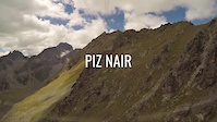
trail: Piz Nair
3:44 |
348 |
Jan 26, 2022 , St. Moritz

trail: Olympia Flow Trail
2:20:30 |
406 |
Jan 4, 2022 , St. Moritz
Recent Trail Reports
Activity Feed
| username | action | type | title | date |
|---|---|---|---|---|
| TobiasCUxVV7 | ridden | trail | activity #96156715 | Jun 3, 2026 @ 8:15am 24 hours |
| pstr | add | report | activity #95511195 and 7 more | May 25, 2026 @ 12:03pm May 25, 2026 |
| SXc328 | wishlist | trail | activity #95294960 | May 23, 2026 @ 1:11am May 23, 2026 |
| Agidley | wishlist | route | activity #94955873 | May 17, 2026 @ 7:12pm May 17, 2026 |
| FGQqRF | wishlist | trail | activity #94709531 | May 14, 2026 @ 1:39pm May 14, 2026 |
Recent Comments
| username | type | title | comment | date |
|---|---|---|---|---|
| trail | It’s mostly a hike-a-bike or push a bike.... | Oct 11, 2025 @ 9:18am Oct 11, 2025 | ||
| trail | Easy trail, a bit of a xc feel on the beginning. | Sep 11, 2025 @ 6:55am Sep 11, 2025 | ||
| trail | Nice panoramoc view, rather a blue flowtrail... | Sep 11, 2025 @ 6:54am Sep 11, 2025 | ||
| trail | Nice, slightly technical ebike climb. | Sep 11, 2025 @ 6:52am Sep 11, 2025 | ||
| trail | Easy gravel road. | Jul 15, 2025 @ 5:08pm Jul 15, 2025 |
Nearby Areas
| name | distance | ||||
|---|---|---|---|---|---|
| Carosello 3000 Mountain Park | 4 | 3 | 12.7 km | ||
| Campo Moro | 1 | 1 | 2 | 1 | 13.6 km |
| Mottolino Bike Park | 4 | 5 | 1 | 14.2 km | |
| Trail zone Palù Park | 2 | 2 | 1 | 14.3 km | |
| Val Surses | 1 | 45 | 15.3 km |
Local Badges
-

Completionist0 awarded
Local Products
Activity Type Stats
| activitytype | trails | distance | descent | descent distance | total vertical | rating | global rank | state rank | photos | reports | routes | ridelogs |
|---|---|---|---|---|---|---|---|---|---|---|---|---|
| Mountain Bike | 83 | 74 miles | 23,865 ft | 40 miles | 4,298 ft | #841 | #11 | 377 | 975 | 1 | 2,823 | |
| E-Bike | 83 | 72 miles | 22,569 ft | 37 miles | 4,298 ft | #132 | 1 | 1,051 | 2 | 495 | ||
| Hike | 75 | 67 miles | 20,371 ft | 34 miles | 4,298 ft | #675 | #13 | 1 | 1,039 | 202 | ||
| Trail Running | 80 | 67 miles | 20,371 ft | 34 miles | 4,298 ft | #383 | #11 | 1,039 | 76 |
Frequently Asked Questions About Engadin
▼
What are the highest rated mountain biking trails in Engadin?
The highest rated mountain biking trails in Engadin are:
- Trais Fluors (4.6/5)
- Suvretta Trail (4.4/5)
- Suvretta da Samedan (4.4/5)
- Tschüchas (4.4/5)
- Olympia Flow Trail (4.3/5)
▼
What is the best time of the year to ride in Engadin?
Based on ride log data, the most popular months to ride in Engadin are:
- July (35 activities)
- August (31 activities)
- September (24 activities)
▼
Where can I park to ride in Engadin?
Check the Engadin trail map for trailhead and parking information. Community members regularly update access and parking details for trails in the area.
▼
What is the longest trail in Engadin?
The longest trail in Engadin is Suvretta da Samedan at 3.2 miles. View all trails sorted by distance.
Activities
Trails
Points of Interest
- By teliMark
 & contributors
 - Admins: apply
- #4349 - 9,789 views
- engadin activity log | embed map of Engadin mountain bike trails | engadin mountain biking points of interest
Downloading of trail gps tracks in kml & gpx formats is enabled for Engadin.
You must login to download files.