close
-
Layers w
- Weather Layers
- Pro
- Pro
- Pro
- Pro
- Pro
- Pro
- More Layers
- Pro
- Pro
- Pro
- Pro
-
Upgrade to

3D
Trail Conditions
- Unknown
- Snow Groomed
- Snow Packed
- Snow Covered
- Snow Cover Partial
- Freeze/thaw Cycle
- Icy
- Prevalent Mud
- Wet
- Variable
- Ideal
- Dry
- Very Dry
Trail Flow (Ridden Direction)
Trailforks scans users ridelogs to determine the most popular direction each trail is ridden. A good flowing trail network will have most trails flowing in a single direction according to their intension.
The colour categories are based on what percentage of riders are riding a trail in its intended direction.
The colour categories are based on what percentage of riders are riding a trail in its intended direction.
- > 96%
- > 90%
- > 80%
- > 70%
- > 50%
- < 50%
- bi-directional trail
- no data
Trail Last Ridden
Trailforks scans ridelogs to determine the last time a trail was ridden.
- < 2 days
- < 1 week
- < 2 weeks
- < 1 month
- < 6 months
- > 6 months
Trail Ridden Direction
The intended direction a trail should be ridden.
- Downhill Only
- Downhill Primary
- Both Directions
- Uphill Primary
- Uphill Only
- One Direction
Contribute Details
Colors indicate trail is missing specified detail.
- Description
- Photos
- Description & Photos
- Videos
Trail Popularity ?
Trailforks scans ridelogs to determine which trails are ridden the most in the last 9 months.
Trails are compared with nearby trails in the same city region with a possible 25 colour shades.
Think of this as a heatmap, more rides = more kinetic energy = warmer colors.
- most popular
- popular
- less popular
- not popular
ATV/ORV/OHV Filter
Max Vehicle Width
inches
US Cell Coverage
Legend

Radar Time
Activity Recordings
Trailforks uses anonymized public activity data.
?
Activity Recordings
Trailforks uses anonymized public activity data.
?
Personal Heatmap
▶
Activity Types
all
/
none
▶
Options
2
Date range
month
–
Winter Trails
Warning
A routing network for winter maps does not exist. Selecting trails using the winter trails layer has been disabled.
Missing Trails
Most Popular
Least Popular
Trails are colored based on popularity. The more popular a trail is, the more red. Less popular trails trend towards green.
Jump Magnitude Heatmap
Heatmap of where riders jump on trails. Zoom in to see individual jumps, click circles to view jump details.
BC Backroad Status
![map legend]()
Service Road Atlas is a free to use, community-driven service for viewing and creating reports on the numerous back-country service roads around B.C. and Alberta.

Slope Aspect
Direction the slope faces
Trails Deemphasized
Trails are shown in grey.
Only show trails with no bike usage.
Suggested Layers
Based on selected activity type
Save the current map location and zoom level as your default home location whenever this page is loaded.
Save
No description for Erli has been added yet!
Login or register to submit one.
This region uses the Uk/Euro style trail grading system.
Activities Click to view
- Mountain Bike
18 trails
- E-Bike
18 trails
- Adaptive Bike
0 trails
- Winter Fat Bike
0 trails
- Hike
17 trails
- Trail Running
17 trails
Region Details
- 3
- 1
- 5
Region Status
Open as of May 30, 2026Stats
- Avg Trail Rating
- Trails (view details)
- 11
- Trails Mountain Bike
- 18
- Trails E-Bike
- 18
- Trails Hike
- 17
- Trails Trail Running
- 17
- Total Distance
- 11 miles
- Total Descent Distance
- 8 miles
- Total Descent
- 6,198 ft
- Total Vertical
- 2,206 ft
- Highest Trailhead
- 3,525 ft
- Reports
- 190
- Photos
- 36
- Ridden Counter
- 3,868
Popular Erli Mountain Biking Trails
• 100 ★ 4.8 • 2 miles • 23 ft • 1,280 •
Sentiero molto bello, guidato e abbastanza naturale, con qualche compressione.
• 90 ★ 4.2 • 4,216 ft • 3 ft • 965 •
Il Conte , antico trail di collegamento tra praetto e il bric schenasso, sentiero restaurato completamente, la prima parte con contropendenze natuali tra pini e noccioli , la seconda e terza parte sponde e drop costruiti.
• 80 ★ 4.4 • 2,943 ft • 2 ft • 554 •
Popular blue difficulty singletrack. This mountain bike primary trail can be used downhill only and has a moderate overall physical rating with a 2 ft blue climb. It features bridge, drop and jump. Trail visibility is sometimes hard to follow.
• 60 ★ 4.9 • 2 miles • 132 ft • 261 •
Highly rated moderately popular blue difficulty singletrack. This mountain bike primary trail. It features jump. On average it takes 15 minutes to complete this trail.
• 20 ★ 4.5 • 1 mile • 42 ft • 48 •
Less popular red difficulty singletrack. This mountain bike primary trail and has a moderate overall physical rating with a 42 ft green climb. It features rock face. On average it takes 11 minutes to complete this trail.
• 10 ★ 0.0 • 3,077 ft • 17 ft • 24 •
Come il nome suggerisce, warm up è un sentiero di riscaldamento prima di affrontare i vari sentieri della zona o per fare pratica con le prime discese. 1 km circa, prima parte di curve larghe tra la faggeta, compressione, una breve...
Erli Mountain Bike Routes
16 miles • 4,179 ft • 0 •
--------------------------------------------------
Photos of Erli Mountain Bike
Videos of Erli Mountain Bike
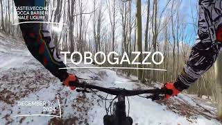
trail: Tobogazzo
14:24 |
87 |
Dec 13, 2024 , Erli
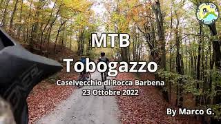
trail: Tobogazzo
7:25 |
494 |
Oct 27, 2022 , Erli
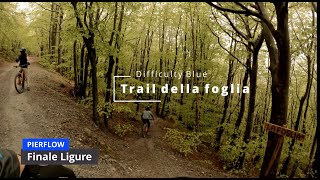
trail: Trail della foglia
6:58 |
243 |
May 12, 2022 , Erli
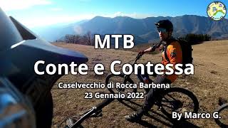
trail: Il Conte P1( T.S.R)
6:29 |
351 |
Jan 29, 2022 , Erli
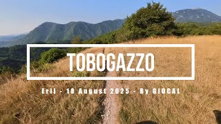
trail: Tobogazzo
19:11 |
143 |
Sep 18, 2025 , Erli
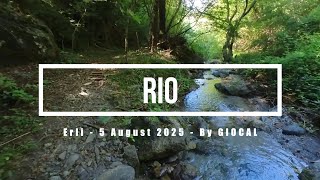
trail: Rio
12:48 |
60 |
Aug 11, 2025 , Erli
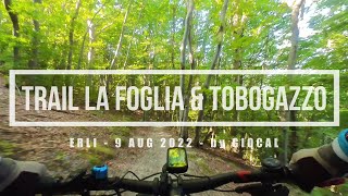
trail: Trail della foglia
15:24 |
289 |
Aug 11, 2022 , Erli
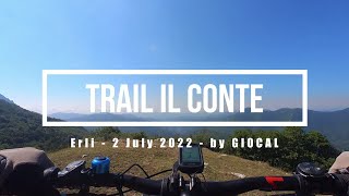
trail: Il Conte P1( T.S.R)
11:06 |
318 |
Jul 14, 2022 , Erli
Recent Trail Reports
| status | trail | date | condition | info | user |
|---|---|---|---|---|---|
| Risalita Rio Collarea | May 30, 2026 @ 9:36am (Europe/Monaco) May 30, 2026 | Ideal | Pistolero79 | ||
| Tobogazzo | May 30, 2026 @ 9:36am (Europe/Monaco) May 30, 2026 | Dry | Pistolero79 | ||
| Il Conte P1( T.S.R) | May 21, 2026 @ 9:47am (Europe/Monaco) May 21, 2026 | Ideal | weridemtbskillscoaching | ||
| Il Conte P2( T.S.R) | Apr 9, 2026 @ 1:22pm (Europe/Monaco) Apr 9, 2026 | Ideal | elbati | ||
| Exit Il Conte | Apr 4, 2026 @ 8:48am (Europe/Monaco) Apr 3, 2026 | Dry | Glaucovassallo | ||
| Trail della foglia | Mar 11, 2026 @ 5:16pm (Europe/Rome) Mar 11, 2026 | Dry | finaleoutdoorregion FOR | ||
| Rio | Feb 25, 2026 @ 2:18pm (Europe/Rome) Feb 25, 2026 | Ideal | finaleoutdoorregion FOR | ||
| Risalita Gazzo / Praetto | Jun 14, 2024 @ 3:00am Jun 14, 2024 | Ideal | NaSA75 | ||
| Sentiero del Poggio | Oct 1, 2023 @ 7:22am Oct 1, 2023 | Dry | barolo71 |
Activity Feed
| username | action | type | title | date |
|---|---|---|---|---|
| matt135fer | ridden | trail | activity #98117267 | Jun 30, 2026 @ 3:16am 3 days |
| MonesTrail | ridden | trail | activity #97576163 | Jun 22, 2026 @ 11:45am Jun 22, 2026 |
| spezies8472 | ridden | trail | activity #97513405 and 2 more | Jun 21, 2026 @ 1:00pm Jun 21, 2026 |
| spezies8472 | wishlist | trail | activity #97512913 and 2 more | Jun 21, 2026 @ 12:54pm Jun 21, 2026 |
| BeeSB | ridden | trail | activity #96353038 | Jun 6, 2026 @ 3:36am Jun 6, 2026 |
Recent Comments
| username | type | title | comment | date |
|---|---|---|---|---|
| trail | strepitoso. condizioni eccelse | Nov 10, 2025 @ 5:00am Nov 10, 2025 | ||
| trail | strepitoso. pulito e lustrato | Nov 10, 2025 @ 5:00am Nov 10, 2025 | ||
| trail | bellissimo. un po' di foglia ma linea sempre... | Nov 10, 2025 @ 4:58am Nov 10, 2025 | ||
| trail | Nn si trova l'inizio dal sentiero | Apr 30, 2025 @ 8:25am Apr 30, 2025 | ||
| trail | Direi solo per e-bike, utile per tornare allo... | Aug 31, 2024 @ 10:42am Aug 31, 2024 |
Local Badges
-

Epic Mountain Bike Climb 2k3 awarded -

Climbing 10k Badge0 awarded -

Mountain Biking 100k Badge0 awarded -

Epic Ride Descent 2k3 awarded -

Descent 10k Badge0 awarded -

Descent 100k Badge0 awarded
Activity Type Stats
| activitytype | trails | distance | descent | descent distance | total vertical | rating | global rank | state rank | photos | reports | routes | ridelogs |
|---|---|---|---|---|---|---|---|---|---|---|---|---|
| Mountain Bike | 18 | 10 miles | 5,997 ft | 7 miles | 2,205 ft | #4,443 | #290 | 33 | 190 | 2 | 846 | |
| E-Bike | 18 | 10 miles | 5,997 ft | 7 miles | 2,205 ft | #837 | #102 | 3 | 190 | 139 | ||
| Hike | 17 | 10 miles | 5,466 ft | 7 miles | 2,205 ft | #9,173 | #598 | 181 | 20 | |||
| Trail Running | 17 | 10 miles | 5,466 ft | 7 miles | 2,205 ft | #8,670 | #575 | 181 |
Frequently Asked Questions About Erli
▼
What are the highest rated mountain biking trails in Erli?
The highest rated mountain biking trails in Erli are:
- Tobogazzo (4.6/5)
- Trail della foglia (4.5/5)
- Il Conte P1( T.S.R) (4.1/5)
- Rio (4.1/5)
- Sentiero del Poggio (4.1/5)
▼
What is the best time of the year to ride in Erli?
Based on ride log data, the most popular months to ride in Erli are:
- September (6 activities)
- November (5 activities)
- August (4 activities)
▼
Where can I park to ride in Erli?
Check the Erli trail map for trailhead and parking information. Community members regularly update access and parking details for trails in the area.
▼
What is the longest trail in Erli?
The longest trail in Erli is Tobogazzo at 2.0 miles. View all trails sorted by distance.
Activities
Trails
Points of Interest
- By Samir88
 TSR & contributors
 - Admins: denitopia
- #22498 - 2,312 views
- erli activity log | embed map of Erli mountain bike trails |
Downloading of trail gps tracks in kml & gpx formats is enabled for Erli.
You must login to download files.