close
-
Layers w
- Weather Layers
- Pro
- Pro
- Pro
- Pro
- Pro
- Pro
- More Layers
- Pro
- Pro
- Pro
- Pro
-
Upgrade to

3D
Trail Conditions
- Unknown
- Snow Groomed
- Snow Packed
- Snow Covered
- Snow Cover Partial
- Freeze/thaw Cycle
- Icy
- Prevalent Mud
- Wet
- Variable
- Ideal
- Dry
- Very Dry
Trail Flow (Ridden Direction)
Trailforks scans users ridelogs to determine the most popular direction each trail is ridden. A good flowing trail network will have most trails flowing in a single direction according to their intension.
The colour categories are based on what percentage of riders are riding a trail in its intended direction.
The colour categories are based on what percentage of riders are riding a trail in its intended direction.
- > 96%
- > 90%
- > 80%
- > 70%
- > 50%
- < 50%
- bi-directional trail
- no data
Trail Last Ridden
Trailforks scans ridelogs to determine the last time a trail was ridden.
- < 2 days
- < 1 week
- < 2 weeks
- < 1 month
- < 6 months
- > 6 months
Trail Ridden Direction
The intended direction a trail should be ridden.
- Downhill Only
- Downhill Primary
- Both Directions
- Uphill Primary
- Uphill Only
- One Direction
Contribute Details
Colors indicate trail is missing specified detail.
- Description
- Photos
- Description & Photos
- Videos
Trail Popularity ?
Trailforks scans ridelogs to determine which trails are ridden the most in the last 9 months.
Trails are compared with nearby trails in the same city region with a possible 25 colour shades.
Think of this as a heatmap, more rides = more kinetic energy = warmer colors.
- most popular
- popular
- less popular
- not popular
ATV/ORV/OHV Filter
Max Vehicle Width
inches
US Cell Coverage
Legend

Radar Time
Activity Recordings
Trailforks uses anonymized public activity data.
?
Activity Recordings
Trailforks uses anonymized public activity data.
?
Personal Heatmap
▶
Activity Types
all
/
none
▶
Options
2
Date range
month
–
Winter Trails
Warning
A routing network for winter maps does not exist. Selecting trails using the winter trails layer has been disabled.
Missing Trails
Most Popular
Least Popular
Trails are colored based on popularity. The more popular a trail is, the more red. Less popular trails trend towards green.
Jump Magnitude Heatmap
Heatmap of where riders jump on trails. Zoom in to see individual jumps, click circles to view jump details.
BC Backroad Status
![map legend]()
Service Road Atlas is a free to use, community-driven service for viewing and creating reports on the numerous back-country service roads around B.C. and Alberta.

Slope Aspect
Direction the slope faces
Trails Deemphasized
Trails are shown in grey.
Only show trails with no bike usage.
Suggested Layers
Based on selected activity type
Save the current map location and zoom level as your default home location whenever this page is loaded.
SaveFiuggi is a comune (municipality) in the province of Frosinone in the region of Lazio in central Italy. The town of Fiuggi became famous for its Acqua di Fiuggi (Fiuggi Water) which flows from its natural springs and mountains. The water has been used in Italy since as early as the 14th century and is famous for its natural healing properties
source: wikipedia
Links
This region uses the Uk/Euro style trail grading system.
Activities Click to view
- Mountain Bike
125 trails
- E-Bike
112 trails
- Gravel Bike
0 trails
- Adaptive Bike
0 trails
- Winter Fat Bike
0 trails
- Horse
23 trails
- Hike
98 trails
- Trail Running
97 trails
- Snowshoe
9 trails
- Downhill Ski
9 trails
- Backcountry Ski
9 trails
- Nordic Ski
9 trails
Region Details
- 12
- 10
- 21
- 32
- 1
Region Status
Open as of 19 hoursStats
- Avg Trail Rating
- Trails (view details)
- 98
- Trails Mountain Bike
- 126
- Trails E-Bike
- 112
- Trails Horse
- 23
- Trails Hike
- 98
- Trails Trail Running
- 97
- Trails Dirtbike/Moto
- 1
- Trails Snowshoe
- 9
- Trails Downhill Ski
- 9
- Trails Backcountry Ski
- 9
- Trails Nordic Ski
- 9
- Total Distance
- 100 miles
- Total Descent
- 32,107 ft
- Total Vertical
- 5,491 ft
- Highest Trailhead
- 6,369 ft
- Reports
- 1,093
- Photos
- 57
- Ridden Counter
- 813
Sub Regions
-
Fiuggi Outdoor Area
- 17
- 18
- 1
Popular Fiuggi Mountain Biking Trails
• 75 ★ 4.5 • 2 miles • 0 ft • 51 •
Popular black difficulty singletrack. This mountain bike primary trail can be used downhill primary and has a hard overall physical rating with a 0 ft double black diamond climb. It features berm, drop, jump and rock garden. On average it takes 40 minutes to complete this trail.
• 90 ★ 4.3 • 4,324 ft • 0 ft • 49 •
• 95 ★ 5.0 • 4,948 ft • 4 ft • 36 •
Popular green difficulty mixed. This mountain bike primary trail can be used downhill primary and has a easy overall physical rating with a 4 ft blue climb. It features wallride. On average it takes 8 minutes to complete this trail.
• 90 ★ 0.0 • 13 miles • 720 ft • 33 •
a wonderful cycle path built on the old railway Rome - Fiuggi, easy to climb, wonderful view, excellent for families
• 100 ★ 0.0 • 1 mile • 82 ft • 33 •
protected cycle path from Fiuggi To Canterno's Lake
• 95 ★ 4.5 • 2,641 ft • 0 ft • 32 •
Popular red difficulty singletrack. This mountain bike primary trail can be used downhill only and has a moderate overall physical rating with a 0 ft black diamond climb. It features drop, jump, gap jump, rock garden and wallride. On average it takes 10 minutes to complete this trail.
• 85 ★ 0.0 • 1,024 ft • 0 ft • 26 •
Popular green difficulty singletrack. This mountain bike primary trail can be used downhill primary and has a easy overall physical rating with a 0 ft blue climb. It features jump. On average it takes 2 minutes to complete this trail.
• 95 ★ 5.0 • 2,126 ft • 3 ft • 24 •
sentiero prevalentemente roccioso, brecciolino su roccia fissa e terra, tratto finale con salti, e drop naturali prima di arrivare in strada e connettersi con presente il bivio per la Volante. Filippo
Fiuggi Mountain Bike Routes
★ 5.0 • 14 miles • 710 ft • 5 • Loop •
Percorso Facile adatto a tutti i riders che attraversa i e gira intorno il paro naturale del lago di canterno
3 miles • 339 ft • 1 • Loop •
Bellissimo percorso all'interno del bosco di Fiuggi, partendo dal centro cittadino, dove poter passeggiare...
7 miles • 1,072 ft • 0 • Out & Back •
Il suggestivo Arco di Trevi ed il tranquillo pianoro di costituiscono due interessanti mete...
22 miles • 2,808 ft • 0 • Out & Back •
Con partenza da Fiuggi, percorrendo la pittoresca “strada vecchia”, ci si dirige ad Anagni, la città...
5 miles • 464 ft • 0 • Loop •
Partenza dall'hotel Ambasciatori, un ottimo percorso con dislivello allenante, visitando la città bassa e...
4 miles • 793 ft • 0 • Loop •
Bellissima passeggiata all'interno del parco degli Altipiani di Arcinazzo, con la visita dell’Arco di...
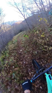
Photos of Fiuggi Mountain Bike
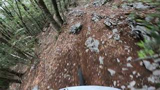
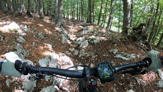
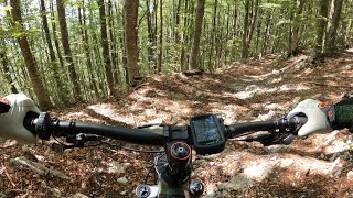
Videos of Fiuggi Mountain Bike
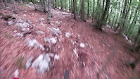
trail: Punta Della Valle
2:22 |
61 |
Aug 30, 2020
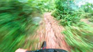
trail: Volante
3:26 |
120 |
Aug 25, 2024 , Fiuggi
trail: Frascara Gara
3:32 |
133 |
Jul 5, 2024 , Fiuggi
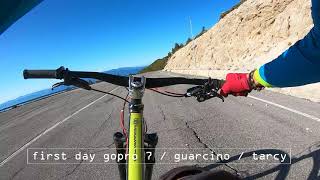
trail: Tarci
0:16 |
406 |
Oct 12, 2020 , Fiuggi
0:23 |
|
Dec 3, 2024
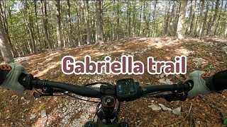
trail: Gabriella
8:38 |
144 |
Oct 30, 2023 , Fiuggi
trail: Frascara
9:45 |
242 |
Oct 6, 2023 , Fiuggi
trail: Frascara Gara
6:00 |
128 |
Oct 3, 2023 , Fiuggi
Current Trail Warnings
| status | trail | date | condition | user | info |
|---|---|---|---|---|---|
| Pineta | Jun 17, 2026 @ 8:49am (Europe/Rome) 19 hours | Dry | sp1marco | Il trail è molto rovinato perchè scavato |
Recent Trail Reports
| status | trail | date | condition | info | user |
|---|---|---|---|---|---|
| Monsignore | Jun 5, 2026 @ 9:41am (Europe/Rome) Jun 5, 2026 | Wet | filiori | ||
| Tarci | Jun 5, 2026 @ 9:41am (Europe/Rome) Jun 5, 2026 | Variable | filiori | ||
| Muro della Fede | Jun 5, 2026 @ 9:41am (Europe/Rome) Jun 5, 2026 | Ideal | filiori | ||
| Jump Line | Jun 2, 2026 @ 9:36am (Europe/Rome) Jun 2, 2026 | Ideal | filiori | ||
| Tombino | Jun 2, 2026 @ 9:36am (Europe/Rome) Jun 2, 2026 | Ideal | filiori | ||
| Tronchetto | Jun 2, 2026 @ 9:36am (Europe/Rome) Jun 2, 2026 | Ideal | filiori | ||
| Ciclabile Fiuggi - Lago di Canterno | May 25, 2026 @ 10:38am (Europe/Rome) May 25, 2026 | Ideal | filiori | ||
| Campo Sportivo - Castagneti Fiuggi | May 25, 2026 @ 10:38am (Europe/Rome) May 25, 2026 | Ideal | filiori | ||
| Locandiere | May 15, 2026 @ 4:37pm (Europe/Rome) May 15, 2026 | Wet | filiori | ||
| Access to Ciclabile | May 15, 2026 @ 4:37pm (Europe/Rome) May 15, 2026 | Wet | filiori |
Activity Feed
| username | action | type | title | date |
|---|---|---|---|---|
| sp1marco | add | report | activity #97165632 | Jun 16, 2026 @ 11:50pm 19 hours |
| massimoMTB | ridden | trail | activity #96876699 and 3 more | Jun 13, 2026 @ 7:51am Jun 13, 2026 |
| DanieleLvHXeS | wishlist | trail | activity #96545116 and 1 more | Jun 8, 2026 @ 9:30am Jun 8, 2026 |
| DanieleLvHXeS | ridden | trail | activity #96542063 | Jun 8, 2026 @ 8:40am Jun 8, 2026 |
| filiori | add | report | activity #96287733 and 2 more | Jun 5, 2026 @ 5:16am Jun 5, 2026 |
Recent Comments
| username | type | title | comment | date |
|---|---|---|---|---|
| trail | Molto bello, da fare assolutamente.... | Oct 18, 2025 @ 11:41pm Oct 18, 2025 | ||
| trail | Bella e pulita | Aug 17, 2024 @ 5:37am Aug 17, 2024 | ||
| trail | Ciao Ragazzi, qualcuno ha info sulle... | Sep 27, 2023 @ 12:56am Sep 27, 2023 | ||
| report | si fa? | Dec 24, 2017 @ 11:02am Dec 24, 2017 |
Local Badges
-

10 Blue Trails4 awarded -

Epic Ride Climb 2k91 awarded -

Climbing 10k Badge19 awarded -

Climbing 100k Badge3 awarded -

Epic Ride Descent 2k151 awarded -

Descent 10k Badge25 awarded
Activity Type Stats
| activitytype | trails | distance | descent | descent distance | total vertical | rating | global rank | state rank | photos | reports | routes | ridelogs |
|---|---|---|---|---|---|---|---|---|---|---|---|---|
| Mountain Bike | 125 | 100 miles | 32,106 ft | 57 miles | 5,492 ft | #1,334 | #34 | 88 | 1,093 | 8 | 3,061 | |
| E-Bike | 112 | 98 miles | 31,056 ft | 55 miles | 5,492 ft | #366 | #34 | 4 | 1,071 | 928 | ||
| Horse | 23 | 3 miles | 180 ft | 4,049 ft | 420 ft | #1,704 | #83 | 281 | 2 | |||
| Hike | 98 | 63 miles | 12,808 ft | 32 miles | 4,439 ft | #3,442 | #114 | 1,056 | 146 | |||
| Trail Running | 97 | 63 miles | 12,808 ft | 32 miles | 4,439 ft | #2,927 | #96 | 1,056 | 101 | |||
| Dirtbike/Moto | 1 | 277 | ||||||||||
| Snowshoe | 9 | #284 | #18 | 3 | ||||||||
| Downhill Ski | 9 | #446 | #39 | 15 | ||||||||
| Backcountry Ski | 9 | #291 | #18 | 42 | ||||||||
| Nordic Ski | 9 | #344 | #13 | 6 |
Frequently Asked Questions About Fiuggi
▼
What are the best places to ride in Fiuggi?
Fiuggi has 1 areas to explore for mountain biking. The top rated areas are:
▼
What are the highest rated mountain biking trails in Fiuggi?
The highest rated mountain biking trails in Fiuggi are:
- Muro della Fede (4.2/5)
- Tombino (4.2/5)
- Feliciara (4.2/5)
- Tarci (4.2/5)
- Sentiero Europa (Altipiani - TRevi (4.1/5)
▼
What is the best time of the year to ride in Fiuggi?
Based on ride log data, the most popular months to ride in Fiuggi are:
- October (7 activities)
- July (6 activities)
- June (5 activities)
▼
Where can I park to ride in Fiuggi?
There are 3 parking locations listed in Fiuggi. The most popular parking spots are: View all parking and trailhead locations on the map to plan your visit.
Activities
Trails
- By filiori
 & contributors
 - Admins: yuribu
- #15709 - 4,796 views
- fiuggi activity log | embed map of Fiuggi mountain bike trails | fiuggi mountain biking points of interest
Downloading of trail gps tracks in kml & gpx formats is enabled for Fiuggi.
You must login to download files.