close
-
Layers w
- Weather Layers
- Pro
- Pro
- Pro
- Pro
- Pro
- Pro
- More Layers
- Pro
- Pro
- Pro
- Pro
-
Upgrade to

3D
Trail Conditions
- Unknown
- Snow Groomed
- Snow Packed
- Snow Covered
- Snow Cover Partial
- Freeze/thaw Cycle
- Icy
- Prevalent Mud
- Wet
- Variable
- Ideal
- Dry
- Very Dry
Trail Flow (Ridden Direction)
Trailforks scans users ridelogs to determine the most popular direction each trail is ridden. A good flowing trail network will have most trails flowing in a single direction according to their intension.
The colour categories are based on what percentage of riders are riding a trail in its intended direction.
The colour categories are based on what percentage of riders are riding a trail in its intended direction.
- > 96%
- > 90%
- > 80%
- > 70%
- > 50%
- < 50%
- bi-directional trail
- no data
Trail Last Ridden
Trailforks scans ridelogs to determine the last time a trail was ridden.
- < 2 days
- < 1 week
- < 2 weeks
- < 1 month
- < 6 months
- > 6 months
Trail Ridden Direction
The intended direction a trail should be ridden.
- Downhill Only
- Downhill Primary
- Both Directions
- Uphill Primary
- Uphill Only
- One Direction
Contribute Details
Colors indicate trail is missing specified detail.
- Description
- Photos
- Description & Photos
- Videos
Trail Popularity ?
Trailforks scans ridelogs to determine which trails are ridden the most in the last 9 months.
Trails are compared with nearby trails in the same city region with a possible 25 colour shades.
Think of this as a heatmap, more rides = more kinetic energy = warmer colors.
- most popular
- popular
- less popular
- not popular
ATV/ORV/OHV Filter
Max Vehicle Width
inches
US Cell Coverage
Legend

Radar Time
Activity Recordings
Trailforks uses anonymized public activity data.
?
Activity Recordings
Trailforks uses anonymized public activity data.
?
Personal Heatmap
▶
Activity Types
all
/
none
▶
Options
2
Date range
month
–
Winter Trails
Warning
A routing network for winter maps does not exist. Selecting trails using the winter trails layer has been disabled.
Missing Trails
Most Popular
Least Popular
Trails are colored based on popularity. The more popular a trail is, the more red. Less popular trails trend towards green.
Jump Magnitude Heatmap
Heatmap of where riders jump on trails. Zoom in to see individual jumps, click circles to view jump details.
BC Backroad Status
![map legend]()
Service Road Atlas is a free to use, community-driven service for viewing and creating reports on the numerous back-country service roads around B.C. and Alberta.

Slope Aspect
Direction the slope faces
Trails Deemphasized
Trails are shown in grey.
Only show trails with no bike usage.
Suggested Layers
Based on selected activity type
Save the current map location and zoom level as your default home location whenever this page is loaded.
Save
No description for Forres has been added yet!
Login or register to submit one.
This region uses the Uk/Euro style trail grading system.
Activities Click to view
- Mountain Bike
29 trails
- E-Bike
22 trails
- Adaptive Bike
0 trails
- Winter Fat Bike
0 trails
- Hike
34 trails
- Trail Running
34 trails
Region Details
- 3
- 18
- 1
- 3
- 4
Region Status
Open as of Jun 23, 2025Stats
- Avg Trail Rating
- Trails (view details)
- 29
- Trails Mountain Bike
- 29
- Trails E-Bike
- 22
- Trails Horse
- 1
- Trails Hike
- 34
- Trails Trail Running
- 34
- Total Distance
- 10 miles
- Total Descent
- 2,306 ft
- Total Vertical
- 961 ft
- Highest Trailhead
- 1,065 ft
- Reports
- 35
- Photos
- 311
- Ridden Counter
- 1,629
Sub Regions
-
Hill of the Wangie
- 3
- 4
-
Sanquhar Woodlands
- 18
- 1
Popular Forres Mountain Biking Trails
• 70 ★ 5.0 • 1,972 ft • 0 ft • 166 •
Popular red difficulty singletrack. This mountain bike primary trail can be used downhill only and has a moderate overall physical rating. It features berm, drop, jump, gap jump and rock garden. On average it takes 5 minutes to complete this trail.
• 90 ★ 4.7 • 678 ft • 0 ft • 159 •
Popular red difficulty singletrack. This mountain bike primary trail can be used downhill primary with a 0 ft blue climb. It features rock garden. On average it takes 4 minutes to complete this trail.
• 45 ★ 5.0 • 1,161 ft • 0 ft • 120 •
Moderately popular red difficulty singletrack. This mountain bike primary trail can be used downhill primary. It features berm, drop, jump and gap jump. On average it takes 3 minutes to complete this trail.
• 80 ★ 4.0 • 1 mile • 77 ft • 79 •
Located in the Sanquhar Woods MTB trails in Forres, this easygoing trail features fun from beginners upwards with a mix of ups and downs, and easy to manage trail features such as gentle berms, rolling pumps and flowing single track....
• 5 ★ 0.0 • 3,524 ft • 5 ft • 36 • • hike
Less popular green difficulty family friendly gravel path. This hike primary trail can be used both directions and has a easy overall physical rating with a 5 ft green climb. Trail visibility is always easy to follow. On average it takes 5 minutes to complete this trail.
• 5 ★ 0.0 • 1,480 ft • 16 ft • 24 • • hike
Less popular green difficulty family friendly gravel path. This hike primary trail can be used both directions and has a easy overall physical rating with a 16 ft green climb. Trail visibility is always easy to follow. On average it takes 2 minutes to complete this trail.
• 5 ★ 0.0 • 476 ft • 0 ft • 19 •
Less popular green difficulty family friendly gravel path. This mountain bike primary trail can be used both directions and has a easy overall physical rating with a 0 ft green climb. Trail visibility is always easy to follow. On average it takes minutes to complete this trail.
• 5 ★ 0.0 • 1,827 ft • 8 ft • 14 • • hike
Less popular green difficulty family friendly paved path. This hike primary trail can be used both directions and has a easy overall physical rating with a 8 ft green climb. Trail visibility is always easy to follow. On average it takes 2 minutes to complete this trail.
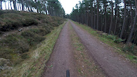
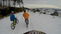
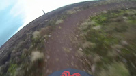
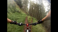
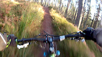
Photos of Forres Mountain Bike
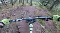
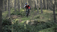
Videos of Forres Mountain Bike
trail: The Canal
0:28 |
595 |
Jan 26, 2020
trail: Gone In 60
0:48 |
671 |
Jun 12, 2018
trail: Law and Order
0:29 |
301 |
Oct 8, 2016
trail: Law and Order
10:30 |
111 |
Feb 21, 2016
trail: Dead Doe
0:54 |
738 |
Jan 25, 2015
trail: Law and Order
15:19 |
198 |
Feb 3, 2014
trail: Law and Order
8:50 |
275 |
Oct 22, 2013
trail: Law and Order
10:22 |
179 |
Jan 9, 2013
Recent Trail Reports
| status | trail | date | condition | info | user |
|---|---|---|---|---|---|
| Sanquhar Sanction | Jun 23, 2025 @ 5:04am Jun 23, 2025 | Variable | MurraykKb73y | ||
| Gone In 60 | Aug 29, 2024 @ 11:02am Aug 29, 2024 | Dry | Faroon | ||
| Law and Order | Aug 29, 2024 @ 11:02am Aug 29, 2024 | Dry | Faroon | ||
| Gi60 top | Aug 29, 2024 @ 11:02am Aug 29, 2024 | Dry | Faroon | ||
| Trail | Jul 23, 2024 @ 1:06am Jul 23, 2024 | Unknown | DeanSimons | ||
| Main Path | Feb 6, 2023 @ 10:55pm Feb 6, 2023 | Wet | owenwatters | ||
| Forest Road | Feb 20, 2021 @ 2:49am Feb 20, 2021 | Wet | Alex-mtb101 | ||
| The Canal | Nov 1, 2020 @ 8:48am Nov 1, 2020 | Ideal | JaJay |
Activity Feed
| username | action | type | title | date |
|---|---|---|---|---|
| LogieMond10 | ridden | trail | activity #95587910 | May 26, 2026 @ 1:46pm May 26, 2026 |
| finnrc03 | ridden | trail | activity #93303835 and 2 more | Apr 24, 2026 @ 1:46pm Apr 24, 2026 |
| DaveiQb3xx | wishlist | region | activity #80033941 | Sep 10, 2025 @ 1:21am Sep 10, 2025 |
| stennydee | wishlist | trail | activity #79184936 | Aug 29, 2025 @ 9:59am Aug 29, 2025 |
| Robi42 | ridden | trail | activity #75654789 and 1 more | Jul 11, 2025 @ 6:58am Jul 11, 2025 |
Recent Comments
| username | type | title | comment | date |
|---|---|---|---|---|
| trail | Top section blocked by tree. Possibly fell by... | Feb 26, 2023 @ 10:03am Feb 26, 2023 | ||
| trail | Probobly the most technical out of the black... | Dec 1, 2020 @ 7:24am Dec 1, 2020 | ||
| trail | Such a good run. Fast and flowy will defo put... | Dec 1, 2020 @ 7:23am Dec 1, 2020 | ||
| trail | Good techie trail, ensure you keep your speed... | Jan 10, 2020 @ 2:17pm Jan 10, 2020 | ||
| trail | Use this trail to get to the red/black routes.... | Jan 10, 2020 @ 2:15pm Jan 10, 2020 |
Local Badges
-

Epic Mountain Bike Climb 2k10 awarded -

Climbing 10k Badge15 awarded -

Mountain Biking 100k Badge0 awarded -

Epic Ride Descent 2k10 awarded -

Descent 10k Badge15 awarded -

Descent 100k Badge0 awarded
Activity Type Stats
| activitytype | trails | distance | descent | descent distance | total vertical | rating | global rank | state rank | photos | reports | routes | ridelogs |
|---|---|---|---|---|---|---|---|---|---|---|---|---|
| Mountain Bike | 29 | 10 miles | 2,306 ft | 4 miles | 961 ft | #4,505 | #152 | 311 | 35 | 3,159 | ||
| E-Bike | 22 | 6 miles | 935 ft | 2 miles | 860 ft | #5,694 | #241 | 21 | 252 | |||
| Horse | 1 | 1,175 ft | 3 ft | 220 ft | 16 ft | |||||||
| Hike | 34 | 9 miles | 955 ft | 3 miles | 886 ft | #6,436 | #165 | 30 | 116 | |||
| Trail Running | 34 | 9 miles | 955 ft | 3 miles | 886 ft | #7,695 | #229 | 30 | 35 |
Frequently Asked Questions About Forres
▼
What are the best places to ride in Forres?
Forres has 2 areas to explore for mountain biking. The top rated areas are:
▼
What are the highest rated mountain biking trails in Forres?
The highest rated mountain biking trails in Forres are:
- Gone In 60 (4.3/5)
- Law and Order (4.2/5)
- Gi60 top (4.2/5)
- Sanquhar Sanction (4/5)
- Path (0/5)
▼
What is the best time of the year to ride in Forres?
Based on ride log data, the most popular months to ride in Forres are:
- July (13 activities)
- March (8 activities)
- December (7 activities)
▼
Where can I park to ride in Forres?
There are 2 parking locations listed in Forres. The most popular parking spots are:
Activities
Trails
- By tomireland FCWT & contributors
- Admins: DMBinS, FLS, NEAT, MMBC, FCWT
- #18567 - 4,148 views
- forres activity log | embed map of Forres mountain bike trails | forres mountain biking points of interest
Downloading of trail gps tracks in kml & gpx formats is enabled for Forres.
You must login to download files.