close
-
Layers w
- Weather Layers
- Pro
- Pro
- Pro
- Pro
- Pro
- Pro
- More Layers
- Pro
- Pro
- Pro
- Pro
-
Upgrade to

3D
Trail Conditions
- Unknown
- Snow Groomed
- Snow Packed
- Snow Covered
- Snow Cover Partial
- Freeze/thaw Cycle
- Icy
- Prevalent Mud
- Wet
- Variable
- Ideal
- Dry
- Very Dry
Trail Flow (Ridden Direction)
Trailforks scans users ridelogs to determine the most popular direction each trail is ridden. A good flowing trail network will have most trails flowing in a single direction according to their intension.
The colour categories are based on what percentage of riders are riding a trail in its intended direction.
The colour categories are based on what percentage of riders are riding a trail in its intended direction.
- > 96%
- > 90%
- > 80%
- > 70%
- > 50%
- < 50%
- bi-directional trail
- no data
Trail Last Ridden
Trailforks scans ridelogs to determine the last time a trail was ridden.
- < 2 days
- < 1 week
- < 2 weeks
- < 1 month
- < 6 months
- > 6 months
Trail Ridden Direction
The intended direction a trail should be ridden.
- Downhill Only
- Downhill Primary
- Both Directions
- Uphill Primary
- Uphill Only
- One Direction
Contribute Details
Colors indicate trail is missing specified detail.
- Description
- Photos
- Description & Photos
- Videos
Trail Popularity ?
Trailforks scans ridelogs to determine which trails are ridden the most in the last 9 months.
Trails are compared with nearby trails in the same city region with a possible 25 colour shades.
Think of this as a heatmap, more rides = more kinetic energy = warmer colors.
- most popular
- popular
- less popular
- not popular
ATV/ORV/OHV Filter
Max Vehicle Width
inches
US Cell Coverage
Legend

Radar Time
Activity Recordings
Trailforks uses anonymized public activity data.
?
Activity Recordings
Trailforks uses anonymized public activity data.
?
Personal Heatmap
▶
Activity Types
all
/
none
▶
Options
2
Date range
month
–
Winter Trails
Warning
A routing network for winter maps does not exist. Selecting trails using the winter trails layer has been disabled.
Missing Trails
Most Popular
Least Popular
Trails are colored based on popularity. The more popular a trail is, the more red. Less popular trails trend towards green.
Jump Magnitude Heatmap
Heatmap of where riders jump on trails. Zoom in to see individual jumps, click circles to view jump details.
BC Backroad Status
![map legend]()
Service Road Atlas is a free to use, community-driven service for viewing and creating reports on the numerous back-country service roads around B.C. and Alberta.

Slope Aspect
Direction the slope faces
Trails Deemphasized
Trails are shown in grey.
Only show trails with no bike usage.
Suggested Layers
Based on selected activity type
Save the current map location and zoom level as your default home location whenever this page is loaded.
SaveArrondissement Gent
Aalter, Deinze, De Pinte, Destelbergen, Evergem, Gavere, Gent, Knesselare, Lochristi, Lovendegem, Melle, Merelbeke, Moerbeke-Waas, Nazareth, Nevele, Oosterzele, Sint-Martens-Latem, Waarschoot, Wachtebeke, Zomergem, Zulte
Aalter, Deinze, De Pinte, Destelbergen, Evergem, Gavere, Gent, Knesselare, Lochristi, Lovendegem, Melle, Merelbeke, Moerbeke-Waas, Nazareth, Nevele, Oosterzele, Sint-Martens-Latem, Waarschoot, Wachtebeke, Zomergem, Zulte
This region uses the Uk/Euro style trail grading system.
Activities Click to view
- Mountain Bike
219 trails
- E-Bike
162 trails
- Gravel Bike
0 trails
- Adaptive Bike
0 trails
- Winter Fat Bike
0 trails
- Horse
46 trails
- Hike
208 trails
- Trail Running
208 trails
- Dirtbike/Moto
21 trails
Region Details
- 45
- 150
- 21
- 3
Region Status
Open as of Jun 1, 2026Stats
- Avg Trail Rating
- Trails (view details)
- 220
- Trails Mountain Bike
- 219
- Trails E-Bike
- 162
- Trails Horse
- 46
- Trails Hike
- 208
- Trails Trail Running
- 208
- Trails Dirtbike/Moto
- 21
- Total Distance
- 84 miles
- Total Descent
- 3,929 ft
- Total Vertical
- 230 ft
- Highest Trailhead
- 230 ft
- Reports
- 964
- Photos
- 125
- Ridden Counter
- 6,290
Sub Regions
-
Bourgoyen-Ossemeersen
- 4
- 1
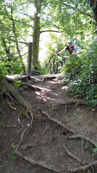
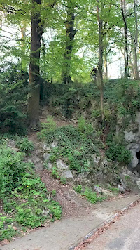
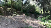
Popular Gent Mountain Biking Trails
• 100 ★ 0.0 • 1,207 ft • 7 ft • 179 •
Popular green difficulty singletrack. This mountain bike primary trail can be used both directions. On average it takes minutes to complete this trail.
• 100 ★ 0.0 • 81 ft • 0 ft • 132 •
Popular blue difficulty singletrack. This mountain bike primary trail can be used downhill primary. On average it takes 1 minutes to complete this trail.
• 100 ★ 4.0 • 788 ft • 11 ft • 125 •
Short trail trough the woods next to and a football field
• 95 ★ 2.0 • 998 ft • 12 ft • 108 •
Popular green difficulty singletrack. This mountain bike primary trail can be used both directions. On average it takes minutes to complete this trail.
• 95 ★ 3.4 • 807 ft • 0 ft • 107 •
Korte maar leuke afdaling, wel opletten voor tegenliggers achter de bocht. Best te vermijden in de winter wegens heel modderige ondergrond
• 100 ★ 4.5 • 922 ft • 6 ft • 97 •
Starting with a short but technical descent partly down the channel berm, the trail continues as a flowy forest trail parallel to the Wezenstraat, climbing back up to street level 2 times. It ends with a moderate descent to the...
• 100 ★ 0.0 • 3,683 ft • 2 ft • 85 •
Popular green difficulty family friendly gravel path. This mountain bike primary trail can be used both directions. On average it takes 2 minutes to complete this trail.
Gent Mountain Bike Routes
★ 5.0 • 63 miles • 1,150 ft • 31 •
trying to fit in ALL known trails around GHENT. Staying within 10k of the R4 NEED SOME HELP FOR THE PART...
★ 3.7 • 17 miles • 335 ft • 0 • Loop •
Official BLOSO (Sport Vlaanderen) route. According to Sport Vlaanderen: 53 % off-road
26 miles • 373 ft • 2 •
MTB tour Knesselare 10 aug 2019 Edited: Cropped privé dpmein and added 2 cross parcours
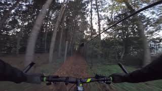
Videos of Gent Mountain Bike
0:05 |
101 |
Jun 28, 2022
0:09 |
234 |
Apr 19, 2021
trail: Enduro downhill Citadelpark
0:12 |
295 |
Apr 17, 2020
0:07 |
620 |
Nov 15, 2018
0:12 |
977 |
Jun 23, 2017

trail: Riva
20:55 |
70 |
Apr 19, 2017
trail: Riva
9:19 |
83 |
Aug 16, 2012
trail: Kalverboswegel
0:15 |
290 |
Nov 14, 2018 , Gent
Recent Trail Reports
Activity Feed
| username | action | type | title | date |
|---|---|---|---|---|
| Ivkov | vote | trail | activity #96021021 and 2 more | Jun 1, 2026 @ 8:58am Jun 1, 2026 |
| Ivkov | add | report | activity #96012892 and 2 more | Jun 1, 2026 @ 6:21am Jun 1, 2026 |
| mariedv | wishlist | route | activity #93707633 and 2 more | Apr 30, 2026 @ 6:07am Apr 30, 2026 |
| mariedv | wishlist | route | activity #93698980 | Apr 30, 2026 @ 1:03am Apr 30, 2026 |
| jaruanob | wishlist | route | activity #93067873 | Apr 21, 2026 @ 2:06am Apr 21, 2026 |
Recent Comments
| username | type | title | comment | date |
|---|---|---|---|---|
| trail | Doesn't exist anymore :( | Apr 22, 2025 @ 4:13pm Apr 22, 2025 | ||
| report | Overgroeid | Dec 7, 2022 @ 4:57am Dec 7, 2022 | ||
| trail | path is shortened, due to construction works... | Nov 5, 2021 @ 2:25am Nov 5, 2021 | ||
| trail | Solid offroad trail between - and through -... | Apr 28, 2021 @ 1:46pm Apr 28, 2021 | ||
| trail | largely forbidden for bikes | Apr 28, 2021 @ 1:32pm Apr 28, 2021 |
Local Badges
-

Epic Ride Climb 2k26 awarded -

Climbing 10k Badge96 awarded -

Climbing 100k Badge10 awarded -

Epic Ride Descent 2k25 awarded -

Descent 10k Badge96 awarded -

Descent 100k Badge10 awarded
Bike & Skill Parks
| name | type | city | rating |
|---|---|---|---|
| Crossbosje Lovendegem | skill park | Gent | |
| Trailpark Lovendegem | skill park | Gent | |
| Crossbos Merendree | skill park | Gent | |
| Malpertuuspark "The Hill" | skill park | Gent | |
| Veermanplein Gent | skill park | Gent |
Activity Type Stats
| activitytype | trails | distance | descent | descent distance | total vertical | rating | global rank | state rank | photos | reports | routes | ridelogs |
|---|---|---|---|---|---|---|---|---|---|---|---|---|
| Mountain Bike | 219 | 84 miles | 3,930 ft | 32 miles | 230 ft | #709 | #6 | 124 | 964 | 12 | 30,478 | |
| E-Bike | 162 | 60 miles | 2,762 ft | 23 miles | 230 ft | #539 | #3 | 936 | 2 | 1,688 | ||
| Horse | 46 | 16 miles | 551 ft | 6 miles | 102 ft | #205 | #1 | 293 | ||||
| Hike | 208 | 80 miles | 3,648 ft | 31 miles | 230 ft | #794 | #6 | 1 | 951 | 1 | 136 | |
| Trail Running | 208 | 80 miles | 3,757 ft | 31 miles | 230 ft | #524 | #6 | 948 | 1 | 3,320 | ||
| Dirtbike/Moto | 21 | 7 miles | 305 ft | 3 miles | 62 ft | #191 | #1 | 292 |
Frequently Asked Questions About Gent
▼
What are the best places to ride in Gent?
Gent has 1 areas to explore for mountain biking. The top rated areas are:
▼
What are the highest rated mountain biking trails in Gent?
The highest rated mountain biking trails in Gent are:
- Freeride loop Schuurstraat (4.2/5)
- Hulseloostraat (4.1/5)
- End of the airfield (4.1/5)
- Jezuietengoed trail (4.1/5)
- Gontrode offroad II (4.1/5)
▼
What is the best time of the year to ride in Gent?
Based on ride log data, the most popular months to ride in Gent are:
- September (61 activities)
- October (50 activities)
- August (37 activities)
▼
Where can I park to ride in Gent?
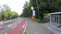
There are 3 parking locations listed in Gent. The most popular parking spots are: View all parking and trailhead locations on the map to plan your visit.
Activities
Trails
Points of Interest
- By TheHill
 MTBTheHill & contributors
 - Admins: MTBTheHill
- #17547 - 11,956 views
- gent activity log | embed map of Gent mountain bike trails | gent mountain biking points of interest
Downloading of trail gps tracks in kml & gpx formats is enabled for Gent.
You must login to download files.