close
-
Layers w
- Weather Layers
- Pro
- Pro
- Pro
- Pro
- Pro
- Pro
- More Layers
- Pro
- Pro
- Pro
- Pro
-
Upgrade to

3D
Trail Conditions
- Unknown
- Snow Groomed
- Snow Packed
- Snow Covered
- Snow Cover Partial
- Freeze/thaw Cycle
- Icy
- Prevalent Mud
- Wet
- Variable
- Ideal
- Dry
- Very Dry
Trail Flow (Ridden Direction)
Trailforks scans users ridelogs to determine the most popular direction each trail is ridden. A good flowing trail network will have most trails flowing in a single direction according to their intension.
The colour categories are based on what percentage of riders are riding a trail in its intended direction.
The colour categories are based on what percentage of riders are riding a trail in its intended direction.
- > 96%
- > 90%
- > 80%
- > 70%
- > 50%
- < 50%
- bi-directional trail
- no data
Trail Last Ridden
Trailforks scans ridelogs to determine the last time a trail was ridden.
- < 2 days
- < 1 week
- < 2 weeks
- < 1 month
- < 6 months
- > 6 months
Trail Ridden Direction
The intended direction a trail should be ridden.
- Downhill Only
- Downhill Primary
- Both Directions
- Uphill Primary
- Uphill Only
- One Direction
Contribute Details
Colors indicate trail is missing specified detail.
- Description
- Photos
- Description & Photos
- Videos
Trail Popularity ?
Trailforks scans ridelogs to determine which trails are ridden the most in the last 9 months.
Trails are compared with nearby trails in the same city region with a possible 25 colour shades.
Think of this as a heatmap, more rides = more kinetic energy = warmer colors.
- most popular
- popular
- less popular
- not popular
ATV/ORV/OHV Filter
Max Vehicle Width
inches
US Cell Coverage
Legend

Radar Time
Activity Recordings
Trailforks uses anonymized public activity data.
?
Activity Recordings
Trailforks uses anonymized public activity data.
?
Personal Heatmap
▶
Activity Types
all
/
none
▶
Options
2
Date range
month
–
Winter Trails
Warning
A routing network for winter maps does not exist. Selecting trails using the winter trails layer has been disabled.
Missing Trails
Most Popular
Least Popular
Trails are colored based on popularity. The more popular a trail is, the more red. Less popular trails trend towards green.
Jump Magnitude Heatmap
Heatmap of where riders jump on trails. Zoom in to see individual jumps, click circles to view jump details.
BC Backroad Status
![map legend]()
Service Road Atlas is a free to use, community-driven service for viewing and creating reports on the numerous back-country service roads around B.C. and Alberta.

Slope Aspect
Direction the slope faces
Trails Deemphasized
Trails are shown in grey.
Only show trails with no bike usage.
Suggested Layers
Based on selected activity type
Save the current map location and zoom level as your default home location whenever this page is loaded.
Save
No description for Graus has been added yet!
Login or register to submit one.
This region uses the Uk/Euro style trail grading system.
Activities Click to view
- Mountain Bike
245 trails
- E-Bike
245 trails
- Gravel Bike
0 trails
- Adaptive Bike
- Horse
7 trails
- Hike
244 trails
- Trail Running
244 trails
Region Details
- 167
- 1
- 63
- 12
Region Status
Open as of May 1, 2026Stats
- Avg Trail Rating
- Trails (view details)
- 243
- Trails Mountain Bike
- 245
- Trails E-Bike
- 245
- Trails Horse
- 7
- Trails Hike
- 244
- Trails Trail Running
- 244
- Trails Dirtbike/Moto
- 2
- Trails Observed Trials
- 2
- Trails ATV/ORV/OHV
- 2
- Total Distance
- 384 miles
- Total Descent Distance
- 182 miles
- Total Descent
- 63,071 ft
- Total Vertical
- 3,589 ft
- Highest Trailhead
- 4,828 ft
- Reports
- 29
- Photos
- 22
- Ridden Counter
- 719
Sub Regions
-
Baja Ribagorza
- 1
- 62
- 10
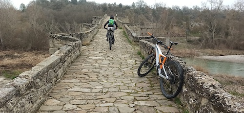
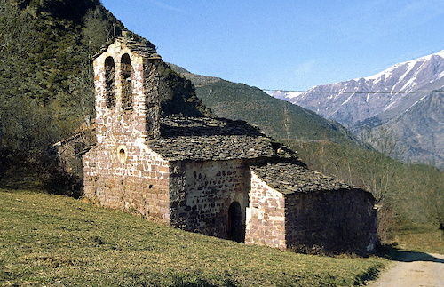
Popular Graus Mountain Biking Trails
• 100 ★ 0.0 • 2 miles • 56 ft • 16 •
Popular blue difficulty wilderness trail. This multi-use trail can be used downhill only and has a moderate overall physical rating with a 56 ft black diamond climb. Trail visibility is always easy to follow. On average it takes 13 minutes to complete this trail.
• 100 ★ 3.0 • 1 mile • 7 ft • 16 •
Popular blue difficulty wilderness trail. This multi-use trail can be used downhill primary and has a moderate overall physical rating with a 7 ft black diamond climb. Trail visibility is always easy to follow. On average it takes 21 minutes to complete this trail.
• 95 ★ 2.0 • 1 mile • 69 ft • 16 •
Popular blue difficulty wilderness trail. This multi-use trail can be used downhill primary and has a moderate overall physical rating with a 69 ft blue climb. Trail visibility is always easy to follow. On average it takes 14 minutes to complete this trail.
• 95 ★ 4.0 • 1 mile • 0 ft • 15 •
Senda que baja desde la Sierra de Sabinós hacia el pueblo de Finestra, en la bajada a nuestra izq veremos La Muralla China de Huesca. Monumento geológico natural....
• 100 ★ 0.0 • 2,054 ft • 57 ft • 14 •
Track sacado de la pag oficial de La Ribagorza BTT. A falta de ciclarla para comentar..
• 100 ★ 0.0 • 2,979 ft • 0 ft • 14 •
Popular blue difficulty wilderness trail. This multi-use trail can be used downhill only and has a moderate overall physical rating with a 0 ft black diamond climb. Trail visibility is always easy to follow. On average it takes 3 minutes to complete this trail.
• 85 ★ 3.0 • 4,888 ft • 0 ft • 12 •
Popular blue difficulty wilderness trail. This multi-use trail can be used downhill primary and has a moderate overall physical rating with a 0 ft blue climb. Trail visibility is always easy to follow. On average it takes 9 minutes to complete this trail.
• 100 ★ 0.0 • 1,273 ft • 141 ft • 10 •
Popular blue difficulty wilderness trail. This multi-use trail can be used uphill primary and has a moderate overall physical rating with a 141 ft blue climb. Trail visibility is always easy to follow. On average it takes 2 minutes to complete this trail.
Graus Mountain Bike Routes
9 miles • 2,547 ft • 7 • Point to Point •
Esta etapa del GR 1 une el fondo del valle del Ésera con la localidad de Pano, ya cerca del límite con...
13 miles • 1,850 ft • 1 • Loop •
Este itinerario recorre las poblaciones situadas en la margen izquierda del valle del Isábena y transita...
17 miles • 2,703 ft • 2 • Loop •
Esta ruta permite recorrer las faldas del Morrón de Güell y conocer de primera mano todo el tramo medio...
34 miles • 5,655 ft • 6 • Loop •
Esta ruta circular, carente de señalización sobre el terreno, transcurre por la zona suroeste de la...
★ 1.7 • 35 miles • 4,304 ft • 7 • Loop •
Ruta panorámica con excelentes vistas del valle del Isábena y del Pirineo. Resulta exigente en lo...
16 miles • 1,284 ft • 7 • Loop •
Ruta circular, carente de señalización sobre el terreno, que transcurre por el entorno del embalse de...
Photos of Graus Mountain Bike
Recent Trail Reports
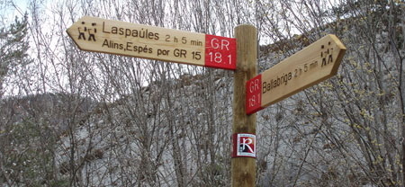
National Scenic Trails & Official Routes
-
GR 17 Vía Arán Pirineos
- Mountain Bike
- E-Bike
- Hike
- Trail Running
-
GR 18 Sendero de la Ribagorza.
- Mountain Bike
- E-Bike
- Horse
- Hike
- Trail Running
-
GR 18.1 Variante Sendero de la Ribagorza
- Mountain Bike
- E-Bike
- Horse
- Hike
- Trail Running
Activity Feed
| username | action | type | title | date |
|---|---|---|---|---|
| Fiti098 | add | report | activity #93848013 and 7 more | May 2, 2026 @ 5:04am May 2, 2026 |
| Miguelxag | wishlist | region | activity #91706213 | Apr 1, 2026 @ 7:34am Apr 1, 2026 |
| Crisjaca | comment | report | activity #82491154 | Oct 17, 2025 @ 12:49am Oct 17, 2025 |
| Crisjaca | like | report | activity #82271393 | Oct 13, 2025 @ 7:46am Oct 13, 2025 |
| tananoaznar | wishlist | region | activity #81837851 | Oct 6, 2025 @ 12:39pm Oct 6, 2025 |
Recent Comments
| username | type | title | comment | date |
|---|---|---|---|---|
| report | Muchas gracias por el aporte | Oct 17, 2025 @ 12:49am Oct 17, 2025 | ||
| trail | Aparte del comentario, que se agradece y... | Sep 1, 2024 @ 2:09am Sep 1, 2024 | ||
| trail | Muchas gracias por el comentario, como ves, en... | Sep 1, 2024 @ 2:08am Sep 1, 2024 | ||
| trail | Sendero perdido..la entrada dolo se aprecia... | Sep 1, 2024 @ 2:03am Sep 1, 2024 | ||
| trail | No sabes si ha pasado empujando la bici,... | Feb 15, 2023 @ 10:21am Feb 15, 2023 |
Local Badges
-

Completionist0 awarded -

Epic Mountain Bike Climb 2k16 awarded -

Climbing 10k Badge4 awarded -

Mountain Biking 100k Badge0 awarded -

Epic Ride Descent 2k16 awarded -

Descent 10k Badge4 awarded
Activity Type Stats
| activitytype | trails | distance | descent | descent distance | total vertical | rating | global rank | state rank | photos | reports | routes | ridelogs |
|---|---|---|---|---|---|---|---|---|---|---|---|---|
| Mountain Bike | 245 | 384 miles | 63,071 ft | 182 miles | 3,589 ft | #734 | #83 | 22 | 29 | 17 | 471 | |
| E-Bike | 245 | 384 miles | 63,071 ft | 182 miles | 3,589 ft | #213 | #91 | 29 | 18 | 33 | ||
| Horse | 7 | 7 miles | 692 ft | 2 miles | 1,227 ft | #2,516 | #210 | 2 | ||||
| Hike | 244 | 384 miles | 63,071 ft | 182 miles | 3,589 ft | #384 | #77 | 29 | 2 | 82 | ||
| Trail Running | 244 | 384 miles | 63,071 ft | 182 miles | 3,589 ft | #295 | #69 | 29 | 2 | 17 | ||
| Dirtbike/Moto | 2 | 2 miles | 23 ft | 886 ft | 554 ft | 1 | ||||||
| Observed Trials | 2 | 2 miles | 23 ft | 886 ft | 554 ft | 1 | ||||||
| ATV/ORV/OHV | 2 | 2 miles | 23 ft | 886 ft | 554 ft | 1 |
Frequently Asked Questions About Graus
▼
What are the best places to ride in Graus?
Graus has 1 areas to explore for mountain biking. The top rated areas are:
▼
What are the highest rated mountain biking trails in Graus?
The highest rated mountain biking trails in Graus are:
- Barranco De Sabinós (4/5)
- Finestras Ermita S.Marcos (4/5)
- El Cajigar Superior (4/5)
- Comallsols (4/5)
- Ermita San Miguel (4/5)
▼
What is the best time of the year to ride in Graus?
Based on ride log data, the most popular months to ride in Graus are:
- November (2 activities)
- March (1 activities)
- October (1 activities)
▼
Where can I park to ride in Graus?
Check the Graus trail map for trailhead and parking information. Community members regularly update access and parking details for trails in the area.
Activities
Trails
- By Crisjaca
 & contributors
 - Admins: juanx, Kalamarrrrrdo
- #47016 - 1,117 views
- graus activity log | embed map of Graus mountain bike trails | graus mountain biking points of interest
Downloading of trail gps tracks in kml & gpx formats is enabled for Graus.
You must login to download files.