close
-
Layers w
- Weather Layers
- Pro
- Pro
- Pro
- Pro
- Pro
- Pro
- More Layers
- Pro
- Pro
- Pro
- Pro
-
Upgrade to

3D
Trail Conditions
- Unknown
- Snow Groomed
- Snow Packed
- Snow Covered
- Snow Cover Partial
- Freeze/thaw Cycle
- Icy
- Prevalent Mud
- Wet
- Variable
- Ideal
- Dry
- Very Dry
Trail Flow (Ridden Direction)
Trailforks scans users ridelogs to determine the most popular direction each trail is ridden. A good flowing trail network will have most trails flowing in a single direction according to their intension.
The colour categories are based on what percentage of riders are riding a trail in its intended direction.
The colour categories are based on what percentage of riders are riding a trail in its intended direction.
- > 96%
- > 90%
- > 80%
- > 70%
- > 50%
- < 50%
- bi-directional trail
- no data
Trail Last Ridden
Trailforks scans ridelogs to determine the last time a trail was ridden.
- < 2 days
- < 1 week
- < 2 weeks
- < 1 month
- < 6 months
- > 6 months
Trail Ridden Direction
The intended direction a trail should be ridden.
- Downhill Only
- Downhill Primary
- Both Directions
- Uphill Primary
- Uphill Only
- One Direction
Contribute Details
Colors indicate trail is missing specified detail.
- Description
- Photos
- Description & Photos
- Videos
Trail Popularity ?
Trailforks scans ridelogs to determine which trails are ridden the most in the last 9 months.
Trails are compared with nearby trails in the same city region with a possible 25 colour shades.
Think of this as a heatmap, more rides = more kinetic energy = warmer colors.
- most popular
- popular
- less popular
- not popular
ATV/ORV/OHV Filter
Max Vehicle Width
inches
US Cell Coverage
Legend

Radar Time
Activity Recordings
Trailforks uses anonymized public activity data.
?
Activity Recordings
Trailforks uses anonymized public activity data.
?
Personal Heatmap
▶
Activity Types
all
/
none
▶
Options
2
Date range
month
–
Winter Trails
Warning
A routing network for winter maps does not exist. Selecting trails using the winter trails layer has been disabled.
Missing Trails
Most Popular
Least Popular
Trails are colored based on popularity. The more popular a trail is, the more red. Less popular trails trend towards green.
Jump Magnitude Heatmap
Heatmap of where riders jump on trails. Zoom in to see individual jumps, click circles to view jump details.
BC Backroad Status
![map legend]()
Service Road Atlas is a free to use, community-driven service for viewing and creating reports on the numerous back-country service roads around B.C. and Alberta.

Slope Aspect
Direction the slope faces
Trails Deemphasized
Trails are shown in grey.
Only show trails with no bike usage.
Suggested Layers
Based on selected activity type
Save the current map location and zoom level as your default home location whenever this page is loaded.
Save
No description for Grayson has been added yet!
Login or register to submit one.
Activities Click to view
- Mountain Bike
23 trails
- E-Bike
21 trails
- Adaptive Bike
- Hike
14 trails
- Trail Running
14 trails
Region Details
- 2
- 3
- 4
- 2
Region Status
Open as of Jun 29, 2024Stats
- Avg Trail Rating
- Trails (view details)
- 14
- Trails Mountain Bike
- 23
- Trails E-Bike
- 21
- Trails Hike
- 14
- Trails Trail Running
- 14
- Total Distance
- 8 miles
- Total Descent Distance
- 3 miles
- Total Descent
- 1,232 ft
- Total Vertical
- 355 ft
- Highest Trailhead
- 1,004 ft
- Reports
- 16
- Photos
- 28
- Ridden Counter
- 172
Sub Regions
-
Grayson Lake State Park
-
Pedaltime @ Grayson Getaways
- 3
- 4
- 2
Popular Grayson Mountain Biking Trails
• 65 ★ 5.0 • 2 miles • 322 ft • 13 •
This trail starts close to bottom hub. Very cool rock overhang with bridge. At the end of the climb you are rewarded with 15 jumps and tabletops. Perfect for beginners. Green or even light blue features
• 70 ★ 4.9 • 620 ft • 0 ft • 11 •
Big blue jump line. 4 tabletops 1 step up and a hip to table at the end Very easy to go fast.
• 95 ★ 5.0 • 715 ft • 0 ft • 11 •
Popular black diamond difficulty singletrack. This mountain bike primary trail can be used downhill only. It features berm, drop and jump. On average it takes 7 minutes to complete this trail.
• 55 ★ 4.6 • 784 ft • 0 ft • 10 •
Highly rated moderately popular blue difficulty singletrack. This mountain bike primary trail can be used both directions. It features berm, drop and jump. On average it takes 8 minutes to complete this trail.
• 100 ★ 4.8 • 482 ft • 0 ft • 10 •
Highly rated popular blue difficulty singletrack. This mountain bike primary trail can be used both directions. It features berm, jump, gap jump and rock garden.
• 50 ★ 4.8 • 1,568 ft • 29 ft • 10 •
Moderately popular blue difficulty singletrack. This mountain bike primary trail can be used downhill only. It features berm, drop and jump. On average it takes 2 minutes to complete this trail.
• 25 ★ 5.0 • 1,132 ft • 0 ft • 9 •
Black level jumps with easy return trail for sessions. Step ups, tables, hips, berms and gaps.
• 80 ★ 5.0 • 3,540 ft • 194 ft • 8 •
Climb trail that starts at campground entrance. You can also enter at the parking are just before the campground. A few small features in this 1.4 mile climb
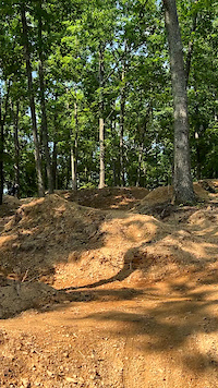
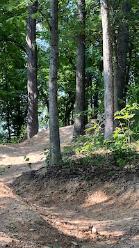
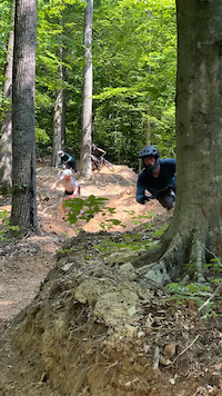
Photos of Grayson Mountain Bike
Videos of Grayson Mountain Bike
youtuber
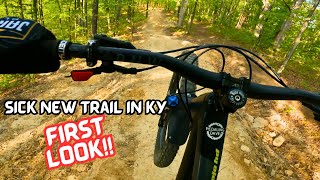
![First Look - New MTB Trail Coming to Eastern...]()
2:38 |
186 |
Jul 30, 2023
trail: Flow State
0:44 |
19 |
Feb 14, 2024
trail: Flow State
0:32 |
13 |
Feb 14, 2024
trail: Giant Slalom
0:26 |
39 |
Feb 14, 2024
Recent Trail Reports
| status | trail | date | condition | info | user |
|---|---|---|---|---|---|
| Giant Slalom | Jun 29, 2024 @ 3:57pm Jun 29, 2024 | Dry | Aaronw0tYHd | ||
| Aaron’s roller coaster | Jun 29, 2024 @ 3:57pm Jun 29, 2024 | Dry | Aaronw0tYHd | ||
| Old Piney Climbing Trail | Jun 29, 2024 @ 3:57pm Jun 29, 2024 | Very Dry | Aaronw0tYHd | ||
| Flow State | Dec 13, 2023 @ 11:28am Dec 13, 2023 | Dry | Aaronw0tYHd | ||
| Rock House Climbing Trail | Nov 5, 2023 @ 9:22am Nov 5, 2023 | Unknown | Aaronw0tYHd | ||
| Flight Training | Aug 11, 2023 @ 8:28am Aug 11, 2023 | Dry | Aaronw0tYHd | ||
| Drop Shipping | Aug 1, 2023 @ 5:58am Aug 1, 2023 | Dry | Aaronw0tYHd |
Activity Feed
| username | action | type | title | date |
|---|---|---|---|---|
| XDptgv | wishlist | region | activity #84992350 | Nov 30, 2025 @ 3:10pm Nov 30, 2025 |
| AstroNova | ridden | trail | activity #83619249 | Nov 5, 2025 @ 7:46am Nov 5, 2025 |
| Yetihunter888 | wishlist | trail | activity #79634338 | Sep 4, 2025 @ 11:03am Sep 4, 2025 |
| Johnddaley | wishlist | region | activity #71133369 | May 6, 2025 @ 4:32pm May 6, 2025 |
| Aaronw0tYHd | add | report | activity #54915340 and 2 more | Jun 30, 2024 @ 5:43am Jun 30, 2024 |
Recent Comments
| username | type | title | comment | date |
|---|---|---|---|---|
| trail | 1.4 mile climb trail to the top of the ridge. ... | Feb 13, 2024 @ 2:38pm Feb 13, 2024 | ||
| report | Good to go | Aug 11, 2023 @ 7:15am Aug 11, 2023 |
Local Badges
-

Epic Mountain Bike Climb 2k0 awarded -

Climbing 10k Badge0 awarded -

Mountain Biking 100k Badge0 awarded -

Epic Ride Descent 2k0 awarded -

Descent 10k Badge0 awarded -

Descent 100k Badge0 awarded
Activity Type Stats
| activitytype | trails | distance | descent | descent distance | total vertical | rating | global rank | state rank | photos | reports | routes | ridelogs |
|---|---|---|---|---|---|---|---|---|---|---|---|---|
| Mountain Bike | 23 | 4 miles | 699 ft | 2 miles | 292 ft | #4,727 | #1,585 | 17 | 16 | 55 | ||
| E-Bike | 21 | 4 miles | 699 ft | 2 miles | 292 ft | #595 | #733 | 11 | 16 | 21 | ||
| Hike | 14 | 4 miles | 531 ft | 2 miles | 167 ft | #12,505 | #4,510 | 11 | 8 | |||
| Trail Running | 14 | 4 miles | 531 ft | 2 miles | 167 ft | #12,651 | #4,445 | 11 | 12 |
Frequently Asked Questions About Grayson
▼
What are the best places to ride in Grayson?
Grayson has 3 areas to explore for mountain biking. The top rated areas are:
▼
What are the highest rated mountain biking trails in Grayson?
The highest rated mountain biking trails in Grayson are:
- Super Dave (4.4/5)
- Aaron’s roller coaster (4.4/5)
- Flow State (4.3/5)
- Giant Slalom (4.3/5)
- Drop Shipping (4.1/5)
▼
Where can I park to ride in Grayson?
There are 5 parking locations listed in Grayson. The most popular parking spots are: View all parking and trailhead locations on the map to plan your visit.
▼
What is the longest trail in Grayson?
The longest trail in Grayson is Rock House Climbing Trail at 1.6 miles. View all trails sorted by distance.
Activities
Trails
Points of Interest
- By Chris-Campbell
 TRAILFORKS & contributors
 - Admins: Pathfinders
- #36042 - 1,727 views
- grayson activity log | embed map of Grayson mountain bike trails | grayson mountain biking points of interest
Downloading of trail gps tracks in kml & gpx formats is enabled for Grayson.
You must login to download files.