close
-
Layers w
- Weather Layers
- Pro
- Pro
- Pro
- Pro
- Pro
- Pro
- More Layers
- Pro
- Pro
- Pro
- Pro
-
Upgrade to

3D
Trail Conditions
- Unknown
- Snow Groomed
- Snow Packed
- Snow Covered
- Snow Cover Partial
- Freeze/thaw Cycle
- Icy
- Prevalent Mud
- Wet
- Variable
- Ideal
- Dry
- Very Dry
Trail Flow (Ridden Direction)
Trailforks scans users ridelogs to determine the most popular direction each trail is ridden. A good flowing trail network will have most trails flowing in a single direction according to their intension.
The colour categories are based on what percentage of riders are riding a trail in its intended direction.
The colour categories are based on what percentage of riders are riding a trail in its intended direction.
- > 96%
- > 90%
- > 80%
- > 70%
- > 50%
- < 50%
- bi-directional trail
- no data
Trail Last Ridden
Trailforks scans ridelogs to determine the last time a trail was ridden.
- < 2 days
- < 1 week
- < 2 weeks
- < 1 month
- < 6 months
- > 6 months
Trail Ridden Direction
The intended direction a trail should be ridden.
- Downhill Only
- Downhill Primary
- Both Directions
- Uphill Primary
- Uphill Only
- One Direction
Contribute Details
Colors indicate trail is missing specified detail.
- Description
- Photos
- Description & Photos
- Videos
Trail Popularity ?
Trailforks scans ridelogs to determine which trails are ridden the most in the last 9 months.
Trails are compared with nearby trails in the same city region with a possible 25 colour shades.
Think of this as a heatmap, more rides = more kinetic energy = warmer colors.
- most popular
- popular
- less popular
- not popular
ATV/ORV/OHV Filter
Max Vehicle Width
inches
US Cell Coverage
Legend

Radar Time
Activity Recordings
Trailforks uses anonymized public activity data.
?
Activity Recordings
Trailforks uses anonymized public activity data.
?
Personal Heatmap
▶
Activity Types
all
/
none
▶
Options
2
Date range
month
–
Winter Trails
Warning
A routing network for winter maps does not exist. Selecting trails using the winter trails layer has been disabled.
Missing Trails
Most Popular
Least Popular
Trails are colored based on popularity. The more popular a trail is, the more red. Less popular trails trend towards green.
Jump Magnitude Heatmap
Heatmap of where riders jump on trails. Zoom in to see individual jumps, click circles to view jump details.
BC Backroad Status
![map legend]()
Service Road Atlas is a free to use, community-driven service for viewing and creating reports on the numerous back-country service roads around B.C. and Alberta.

Slope Aspect
Direction the slope faces
Trails Deemphasized
Trails are shown in grey.
Only show trails with no bike usage.
Suggested Layers
Based on selected activity type
Save the current map location and zoom level as your default home location whenever this page is loaded.
Save
No description for Hellendoorn has been added yet!
Login or register to submit one.
Activities Click to view
- Mountain Bike
9 trails
- Hike
6 trails
- Trail Running
6 trails
Region Details
- 7
- 2
Region Status
Open as of Oct 18, 2025Stats
- Avg Trail Rating
- Trails (view details)
- 9
- Trails Mountain Bike
- 9
- Trails E-Bike
- 1
- Trails Hike
- 6
- Trails Trail Running
- 6
- Total Distance
- 11 miles
- Total Descent Distance
- 4 miles
- Total Descent
- 732 ft
- Total Vertical
- 130 ft
- Highest Trailhead
- 171 ft
- Reports
- 64
- Photos
- 62
- Ridden Counter
- 2,881
Popular Hellendoorn Mountain Biking Trails
• 90 ★ 0.0 • 2,687 ft • 57 ft • 461 •
Popular blue difficulty singletrack. This mountain bike primary trail can be used one direction and has a hard overall physical rating with a 57 ft black diamond climb. Trail visibility is always easy to follow. On average it takes 3 minutes to complete this trail.
• 35 ★ 4.0 • 2 miles • 65 ft • 415 •
Less popular blue difficulty singletrack. This mountain bike primary trail can be used one direction. On average it takes 8 minutes to complete this trail.
• 80 ★ 0.0 • 1,690 ft • 0 ft • 289 •
Popular green difficulty singletrack. This mountain bike primary trail can be used one direction. Trail visibility is always easy to follow. On average it takes 1 minutes to complete this trail.
• 70 ★ 0.0 • 1 mile • 112 ft • 280 •
Popular green difficulty singletrack. This mountain bike primary trail can be used one direction and has a easy overall physical rating. It features berm. Trail visibility is always easy to follow. On average it takes 8 minutes to complete this trail.
• 45 ★ 5.0 • 2 miles • 65 ft • 275 •
Moderately popular green difficulty mixed. This mountain bike primary trail can be used one direction and has a easy overall physical rating. Trail visibility is always easy to follow. On average it takes 7 minutes to complete this trail.
• 60 ★ 0.0 • 3 miles • 208 ft • 273 •
Moderately popular green difficulty singletrack. This mountain bike primary trail can be used one direction and has a moderate overall physical rating with a 208 ft green climb. Trail visibility is always easy to follow. On average it takes 17 minutes to complete this trail.
• 25 ★ 0.0 • 1 mile • 80 ft • 273 •
Less popular green difficulty singletrack. This mountain bike primary trail can be used one direction. It features berm. On average it takes 5 minutes to complete this trail.
• 100 ★ 0.0 • 1,565 ft • 0 ft • 263 •
Popular green difficulty singletrack. This mountain bike primary trail can be used one direction. On average it takes 1 minutes to complete this trail.
Hellendoorn Mountain Bike Routes
★ 4.5 • 10 miles • 527 ft • 0 • Loop •
Purple route with mountainbike markings
12 miles • 385 ft • 1 •
MTB Route Nijverdal. Voor meer informatie: https://www.mtbroutes.nl/overijssel/nijverdal
11 miles • 634 ft • 0 •
Mainly hard packed sandy MTB route that has some nice flow but no real big climbs with one fairly steep...
11 miles • 493 ft • 0 •
MTB route Helendoorn. Voor meer informatie: https://www.mtbroutes.nl/overijssel/hellendoorn
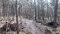
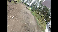
Photos of Hellendoorn Mountain Bike
Videos of Hellendoorn Mountain Bike
trail: Hellendoorn
0:13 |
166 |
Aug 21, 2019
trail: Hellendoorn
2:44 |
222 |
May 15, 2012
youtuber
![Hellendoorn // MTB Challenge]()

trail: Hellendoorn MTB
6:20 |
146 |
Jan 2, 2024 , Hellendoorn
Recent Trail Reports
| status | trail | date | condition | info | user |
|---|---|---|---|---|---|
| Nijverdal MTB | Oct 18, 2025 @ 5:16pm (Europe/Amsterdam) Oct 18, 2025 | Ideal | Knagie | ||
| Hellendoorn MTB | May 5, 2025 @ 5:50pm May 5, 2025 | Dry | MartinWinterman | ||
| Hellendoorn MTB | Dec 29, 2024 @ 8:38am Dec 29, 2024 | Dry | koendekkers | ||
| Sanatoriumklim en afdaling | Dec 29, 2024 @ 8:38am Dec 29, 2024 | Ideal | koendekkers | ||
| Hellendoorn MTB | Dec 29, 2024 @ 8:38am Dec 29, 2024 | Dry | koendekkers | ||
| Hellendoorn MTB | Dec 29, 2024 @ 8:38am Dec 29, 2024 | Dry | koendekkers | ||
| Hellendoorn MTB | Dec 29, 2024 @ 8:38am Dec 29, 2024 | Dry | koendekkers | ||
| Hellendoorn | Oct 6, 2024 @ 2:20pm Oct 6, 2024 | Ideal | Superjeepee | ||
| Hellendoorn | May 10, 2024 @ 5:09am May 10, 2024 | Dry | JelleF1gxZV |
Activity Feed
| username | action | type | title | date |
|---|---|---|---|---|
| iconay | ridden | trail | activity #87067403 | Jan 12, 2026 @ 1:21am Jan 12, 2026 |
| update | event | activity #85611554 | Dec 16, 2025 @ 8:27am Dec 16, 2025 | |
| update | event | activity #85576425 | Dec 15, 2025 @ 11:36am Dec 15, 2025 | |
| Knagie | add | report | activity #82629209 | Oct 19, 2025 @ 1:52am Oct 19, 2025 |
| MartinWinterman | add | report | activity #71060153 | May 5, 2025 @ 11:06am May 5, 2025 |
Bike & Skill Parks
| name | type | city | rating |
|---|---|---|---|
| Circuit De Koetree motocross | skill park | Hellendoorn |
Activity Type Stats
| activitytype | trails | distance | descent | descent distance | total vertical | rating | global rank | state rank | photos | reports | routes | ridelogs |
|---|---|---|---|---|---|---|---|---|---|---|---|---|
| Mountain Bike | 9 | 11 miles | 732 ft | 4 miles | 131 ft | #2,650 | #18 | 62 | 64 | 4 | 2,734 | |
| E-Bike | 1 | 2,687 ft | 46 ft | 1,670 ft | 59 ft | 63 | 2 | 52 | ||||
| Hike | 6 | 7 miles | 463 ft | 3 miles | 105 ft | #3,194 | #33 | 64 | 22 | |||
| Trail Running | 6 | 7 miles | 463 ft | 3 miles | 105 ft | #2,679 | #32 | 64 | 39 |
Frequently Asked Questions About Hellendoorn
▼
What are the highest rated mountain biking trails in Hellendoorn?
The highest rated mountain biking trails in Hellendoorn are:
- Hellendoorn MTB (4.1/5)
- Hellendoorn (4/5)
- Nijverdal MTB (0/5)
- Sanatoriumklim en afdaling (0/5)
- Hellendoorn MTB (0/5)
▼
What is the best time of the year to ride in Hellendoorn?
Based on ride log data, the most popular months to ride in Hellendoorn are:
- December (9 activities)
- January (7 activities)
- May (6 activities)
▼
Where can I park to ride in Hellendoorn?
Check the Hellendoorn trail map for trailhead and parking information. Community members regularly update access and parking details for trails in the area.
▼
What is the longest trail in Hellendoorn?
The longest trail in Hellendoorn is Hellendoorn MTB at 5.4 km. View all trails sorted by distance.
- By Inonyx & contributors
- Admins: apply
- #21222 - 2,899 views
- hellendoorn activity log | embed map of Hellendoorn mountain bike trails |
Downloading of trail gps tracks in kml & gpx formats is enabled for Hellendoorn.
You must login to download files.