close
-
Layers w
- Weather Layers
- Pro
- Pro
- Pro
- Pro
- Pro
- Pro
- More Layers
- Pro
- Pro
- Pro
- Pro
-
Upgrade to

3D
Trail Conditions
- Unknown
- Snow Groomed
- Snow Packed
- Snow Covered
- Snow Cover Partial
- Freeze/thaw Cycle
- Icy
- Prevalent Mud
- Wet
- Variable
- Ideal
- Dry
- Very Dry
Trail Flow (Ridden Direction)
Trailforks scans users ridelogs to determine the most popular direction each trail is ridden. A good flowing trail network will have most trails flowing in a single direction according to their intension.
The colour categories are based on what percentage of riders are riding a trail in its intended direction.
The colour categories are based on what percentage of riders are riding a trail in its intended direction.
- > 96%
- > 90%
- > 80%
- > 70%
- > 50%
- < 50%
- bi-directional trail
- no data
Trail Last Ridden
Trailforks scans ridelogs to determine the last time a trail was ridden.
- < 2 days
- < 1 week
- < 2 weeks
- < 1 month
- < 6 months
- > 6 months
Trail Ridden Direction
The intended direction a trail should be ridden.
- Downhill Only
- Downhill Primary
- Both Directions
- Uphill Primary
- Uphill Only
- One Direction
Contribute Details
Colors indicate trail is missing specified detail.
- Description
- Photos
- Description & Photos
- Videos
Trail Popularity ?
Trailforks scans ridelogs to determine which trails are ridden the most in the last 9 months.
Trails are compared with nearby trails in the same city region with a possible 25 colour shades.
Think of this as a heatmap, more rides = more kinetic energy = warmer colors.
- most popular
- popular
- less popular
- not popular
ATV/ORV/OHV Filter
Max Vehicle Width
inches
US Cell Coverage
Legend

Radar Time
Activity Recordings
Trailforks uses anonymized public activity data.
?
Activity Recordings
Trailforks uses anonymized public activity data.
?
Personal Heatmap
▶
Activity Types
all
/
none
▶
Options
2
Date range
month
–
Winter Trails
Warning
A routing network for winter maps does not exist. Selecting trails using the winter trails layer has been disabled.
Missing Trails
Most Popular
Least Popular
Trails are colored based on popularity. The more popular a trail is, the more red. Less popular trails trend towards green.
Jump Magnitude Heatmap
Heatmap of where riders jump on trails. Zoom in to see individual jumps, click circles to view jump details.
BC Backroad Status
![map legend]()
Service Road Atlas is a free to use, community-driven service for viewing and creating reports on the numerous back-country service roads around B.C. and Alberta.

Slope Aspect
Direction the slope faces
Trails Deemphasized
Trails are shown in grey.
Only show trails with no bike usage.
Suggested Layers
Based on selected activity type
Save the current map location and zoom level as your default home location whenever this page is loaded.
SaveIgman (Serbian Cyrillic: Игман, pronounced [îɡman]) is a mountain plateau in central Bosnia and Herzegovina. Geologically, Igman is part of the Dinaric Alps and formed largely of secondary and tertiary sedimentary rock, mostly Limestone. It is located southwest of Sarajevo, bordering the Bjelašnica range in the south and west, Hadžići and Ilidža in the north, and the river Željeznica in the east. Igman's highest point, Crni vrh, west of the Malo Polje road, at an altitude of 1,510 metres (4,954 feet), the homonym highest elevation on the east side of this road reaches an elevation of 1,502 metres (4,928 feet). Most of Igman is covered with mixed forest with local pastures (f.i.: Veliko Polje: Large Field, Malo Polje: Small Field). Igman was the location of the lowest recorded temperature in the region, −43 °C (−45 °F). Igman has been the site of extensive combat during the 1992-95 Siege of Sarajevo and certain areas, in particular the surroundings of former front lines, feature a high mine risk.[1]
source: Wiki
Primary Trail Type: Cross-Country
Shuttleable: YES
Land Status: City Managed
 google parking directions
Links
Activities Click to view
- Mountain Bike
65 trails
- E-Bike
51 trails
- Horse
28 trails
- Hike
55 trails
- Trail Running
57 trails
- Dirtbike/Moto
31 trails
- Observed Trials
5 trails
- ATV/ORV/OHV
32 trails
Region Details
- 25
- 9
- 21
- 9
- 1
Region Status
Caution as of Apr 26, 2026Stats
- Avg Trail Rating
- Trails (view details)
- 65
- Trails Mountain Bike
- 65
- Trails E-Bike
- 51
- Trails Horse
- 28
- Trails Hike
- 55
- Trails Trail Running
- 57
- Trails Dirtbike/Moto
- 31
- Trails Observed Trials
- 5
- Trails ATV/ORV/OHV
- 32
- Trails Snowmobile
- 3
- Trails Snowshoe
- 3
- Trails Downhill Ski
- 3
- Trails Backcountry Ski
- 3
- Trails Nordic Ski
- 3
- Total Distance
- 93 miles
- Total Descent
- 17,073 ft
- Total Vertical
- 3,561 ft
- Highest Trailhead
- 5,196 ft
- Reports
- 88
- Photos
- 61
- Ridden Counter
- 580
Popular Igman Mountain Biking Trails
• 100 ★ 5.0 • 433 ft • 0 ft • 24 •
Popular blue difficulty singletrack. This mountain bike primary trail can be used both directions and has a moderate overall physical rating with a 0 ft blue climb. Trail visibility is always easy to follow. On average it takes 1 minutes to complete this trail.
• 80 ★ 5.0 • 2,172 ft • 33 ft • 15 •
Popular green difficulty dirt/gravel road. This mountain bike primary trail can be used downhill primary and has a easy overall physical rating with a 33 ft green climb. Trail visibility is always easy to follow. On average it takes 12 minutes to complete this trail. A license is required to use this trail.
• 55 ★ 4.4 • 2 miles • 0 ft • 14 •
Moderately popular black diamond difficulty singletrack. This mountain bike primary trail can be used downhill only and has a moderate overall physical rating with a 0 ft blue climb. It features rock face and skinny. Trail visibility is sometimes hard to follow. On average it takes 14 minutes to complete this trail.
• 70 ★ 5.0 • 2 miles • 114 ft • 12 •
Popular blue difficulty singletrack. This mountain bike primary trail can be used downhill primary. It features rock face. On average it takes 14 minutes to complete this trail.
• 65 ★ 5.0 • 2 miles • 100 ft • 12 •
Moderately popular green difficulty dirt/gravel road. This multi-use trail can be used downhill primary and has a easy overall physical rating with a 100 ft green climb. Trail visibility is always easy to follow. On average it takes 7 minutes to complete this trail.
• 5 ★ 0.0 • 1 mile • 15 ft • 10 •
The middle of the road is reserved for pedestrians and carriages. On the left and right, the narrow path is great for MTB rides
• 65 ★ 5.0 • 2 miles • 161 ft • 9 •
Moderately popular white difficulty family friendly dirt/gravel road. This multi-use trail can be used both directions and has a easy overall physical rating. Trail visibility is always easy to follow. On average it takes 36 minutes to complete this trail.
Igman Mountain Bike Routes
★ 5.0 • 25 miles • 4,050 ft • 4 • Loop •
MTB Marathon is a route that combines history, physical challenge, and absolute isolation in nature. This...
★ 5.0 • 6 miles • 1,158 ft • 0 • Point to Point •
small trail, 10 km lenghts. The descent to Stojecevac is more than excellent.
34 miles • 3,902 ft • 0 • Point to Point •
Riding three mountains is a beautiful cycling route that stretches from via Bjelasnica and Treskavica.
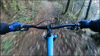
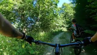
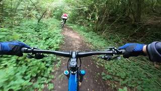
Photos of Igman Mountain Bike
Videos of Igman Mountain Bike

trail: Igman - Stojcevac
4:59 |
353 |
Mar 19, 2022 , Sarajevo
trail: Igman - Stojcevac
6:49 |
159 |
Jan 2, 2022 , Sarajevo
trail: Ravna Vala - Babin Do
10:05 |
173 |
Nov 6, 2021 , Sarajevo
trail: Igman - Stojcevac
3:49 |
259 |
Nov 5, 2021 , Sarajevo
Recent Trail Reports
| status | trail | date | condition | info | user |
|---|---|---|---|---|---|
| Igman - Stojcevac | Feb 12, 2026 @ 2:26pm (Europe/Sarajevo) Feb 12, 2026 | Unknown | marko-ristivojevic-evolution MTB Evolution | ||
| Velika Aleja | Feb 5, 2024 @ 4:04am Feb 5, 2024 | Unknown | marko-ristivojevic-evolution MTB Evolution | ||
| Stojcevac | Feb 5, 2024 @ 4:04am Feb 5, 2024 | Ideal | marko-ristivojevic-evolution MTB Evolution | ||
| Igmanska cesta | Apr 30, 2023 @ 11:54pm Apr 30, 2023 | Variable | Pityuka | ||
| Igmanska cesta | Apr 30, 2023 @ 11:54pm Apr 30, 2023 | Variable | Pityuka | ||
| Igmaniska cesta | Apr 30, 2023 @ 11:54pm Apr 30, 2023 | Wet | Pityuka | ||
| Igmanska cesta | Apr 30, 2023 @ 11:54pm Apr 30, 2023 | Wet | Pityuka | ||
| Igmanska Cesta | Apr 30, 2023 @ 11:54pm Apr 30, 2023 | Wet | Pityuka | ||
| Igmanska cesta | Apr 30, 2023 @ 11:54pm Apr 30, 2023 | Wet | Pityuka | ||
| Igmanska cesta | Apr 30, 2023 @ 11:54pm Apr 30, 2023 | Wet | Pityuka |
Activity Feed
| username | action | type | title | date |
|---|---|---|---|---|
| marko-ristivojevic-evolution | add | route | activity #95162635 | May 21, 2026 @ 2:31am May 21, 2026 |
| marko-ristivojevic-evolution | add | photo | activity #90606213 | Mar 14, 2026 @ 11:53pm Mar 14, 2026 |
| marko-ristivojevic-evolution | update | route | activity #90605891 | Mar 14, 2026 @ 11:32pm Mar 14, 2026 |
| marko-ristivojevic-evolution | update | route | activity #90531988 | Mar 13, 2026 @ 11:44pm Mar 13, 2026 |
| marko-ristivojevic-evolution | update | region | activity #90531904 | Mar 13, 2026 @ 11:40pm Mar 13, 2026 |
Recent Comments
| username | type | title | comment | date |
|---|---|---|---|---|
| trail | Extremely rocky. Fast and the thec | Jul 29, 2021 @ 12:10pm Jul 29, 2021 | ||
| trail | One of the best trails around Sarajevo so long. | Oct 19, 2019 @ 5:21am Oct 19, 2019 | ||
| trail | Trail heavily damaged by harvesters... | Oct 19, 2019 @ 5:20am Oct 19, 2019 |
Nearby Areas
| name | distance | ||||
|---|---|---|---|---|---|
| Bike Park Evolution | 11 | 2 | 4 | 6.7 km | |
| Bjelašnica | 7 | 2 | 2 | 8.8 km | |
| East Sarajevo trails | 6 | 1 | 9.5 km | ||
| Trebevic | 9 | 13 | 3 | 10.2 km | |
| Trnovo trails | 1 | 12.4 km |
Local Badges
-
Igman4 awarded -

Completionist0 awarded
Activity Type Stats
| activitytype | trails | distance | descent | descent distance | total vertical | rating | global rank | state rank | photos | reports | routes | ridelogs |
|---|---|---|---|---|---|---|---|---|---|---|---|---|
| Mountain Bike | 65 | 93 miles | 17,073 ft | 48 miles | 3,563 ft | #732 | #1 | 60 | 88 | 4 | 497 | |
| E-Bike | 51 | 80 miles | 15,174 ft | 41 miles | 3,560 ft | #514 | #1 | 1 | 73 | 3 | 29 | |
| Horse | 28 | 51 miles | 7,320 ft | 24 miles | 3,560 ft | #99 | #1 | 13 | ||||
| Hike | 55 | 83 miles | 15,673 ft | 43 miles | 3,563 ft | #745 | #1 | 83 | 1 | 60 | ||
| Trail Running | 57 | 84 miles | 15,764 ft | 44 miles | 3,563 ft | #358 | #1 | 83 | 1 | 94 | ||
| Dirtbike/Moto | 31 | 55 miles | 7,552 ft | 26 miles | 3,560 ft | #112 | #1 | 14 | ||||
| Observed Trials | 5 | 7 miles | 266 ft | 1 mile | 1,867 ft | #84 | #1 | |||||
| ATV/ORV/OHV | 32 | 55 miles | 7,021 ft | 25 miles | 3,560 ft | #42 | #1 | 14 | ||||
| Snowmobile | 3 | 1 mile | 75 ft | 2,684 ft | 59 ft | |||||||
| Snowshoe | 3 | 1 mile | 75 ft | 2,684 ft | 59 ft | 1 | ||||||
| Downhill Ski | 3 | 1 mile | 75 ft | 2,684 ft | 59 ft | 1 | ||||||
| Backcountry Ski | 3 | 1 mile | 75 ft | 2,684 ft | 59 ft | 1 | ||||||
| Nordic Ski | 3 | 1 mile | 75 ft | 2,684 ft | 59 ft | 1 |
Frequently Asked Questions About Igman
▼
What are the highest rated mountain biking trails in Igman?
The highest rated mountain biking trails in Igman are:
- Nanica Put (4.2/5)
- Igman - Stojcevac (4.1/5)
- Igman Trail (4.1/5)
- Igman - Stojcevac (4.1/5)
- Ajišnik (4.1/5)
▼
What is the best time of the year to ride in Igman?
Based on ride log data, the most popular months to ride in Igman are:
- May (22 activities)
- April (10 activities)
- July (9 activities)
▼
Where can I park to ride in Igman?
▼
What is the longest trail in Igman?
The longest trail in Igman is Ravna Vala Krug at 11.2 miles. View all trails sorted by distance.
Activities
Trails
Points of Interest
- By FaruK-AM & contributors
- Admins: marko-ristivojevic-evolution
- #7475 - 6,241 views
- igman activity log | embed map of Igman mountain bike trails | igman mountain biking points of interest
Downloading of trail gps tracks in kml & gpx formats is enabled for Igman.
You must login to download files.