
close
3D
Trail Conditions
- Unknown
- Snow Groomed
- Snow Packed
- Snow Covered
- Snow Cover Partial
- Freeze/thaw Cycle
- Icy
- Prevalent Mud
- Wet
- Variable
- Ideal
- Dry
- Very Dry
Trail Flow (Ridden Direction)
Trailforks scans users activity logs to determine the most popular direction each trail is ridden. A good flowing trail network will have most trails flowing in a single direction according to their intension.
The colour categories are based on what percentage of users are riding a trail in its intended direction.
The colour categories are based on what percentage of users are riding a trail in its intended direction.
- > 96%
- > 90%
- > 80%
- > 70%
- > 50%
- < 50%
- bi-directional trail
- no data
Trail Last Used
Trailforks scans activity logs to determine the last time a trail was ridden.
- < 2 days
- < 1 week
- < 2 weeks
- < 1 month
- < 6 months
- > 6 months
Trail Ridden Direction
The intended direction a trail should be ridden.
- Downhill Only
- Downhill Primary
- Both Directions
- Uphill Primary
- Uphill Only
- One Direction
Contribute Details
Colors indicate trail is missing specified detail.
- Description
- Photos
- Description & Photos
- Videos
Trail Popularity ?
Trailforks scans activity logs to determine which trails are ridden the most in the last 9 months.
Trails are compared with nearby trails in the same city region with a possible 25 colour shades.
Think of this as a heatmap, more activities = more kinetic energy = warmer colors.
- most popular
- popular
- less popular
- not popular
ATV/ORV/OHV Filter
Max Vehicle Width
inches
US Cell Coverage
Legend

Radar Time
Activity Recordings
Trailforks uses anonymized public activity data.
?
Activity Recordings
Trailforks uses anonymized public activity data.
?
Winter Trails
Warning
A routing network for winter maps does not exist. Selecting trails using the winter trails layer has been disabled.
Missing Trails
Most Popular
Least Popular
Trails are colored based on popularity. The more popular a trail is, the more red. Less popular trails trend towards green.
Jump Magnitude Heatmap
Heatmap of where users jump on trails. Zoom in to see individual jumps, click circles to view jump details.
BC Backroad Status
![map legend]()
Service Road Atlas is a free to use, community-driven service for viewing and creating reports on the numerous back-country service roads around B.C. and Alberta.

Slope Aspect
Direction the slope faces
Trails Deemphasized
Trails are shown in grey.
Only show trails with no bike usage.
Suggested Layers
Based on selected activity type
Save the current map location and zoom level as your default home location whenever this page is loaded.
SaveInverell is an inland town of 12,000 people, and has a few MTB areas within the local district. It is mainly dry, and has suitable riding year round. The soil type in the district is primarily granite/gravel, so usually good drainage on most trails year round, with sandy patches here and there.
Inverell town grew up shadow of the Grafton to Inverell Road Cycling Race, so there are plenty of cyclists around... and a few of them have a Mountain bike as well ha ha, so Inverell township has a few river paths and some cycleways around town, and also an off-the-road Cycle Circuit (bitumen) near the Inverell Lake.
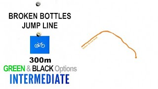
As for MTB, 5klms south of Inverell on the Bundarra Rd 10mins drive south of town is the Inverell MTB Park, you can even ride to the Park along side the roadway for about 2klms, and then there are green single tracks in the bush beside the Bundarra Rd roadway for the final 3klms... The Inverell MTB Park has a good selection of mostly XC single track, with GREEN, BLUE and a few BLACK trails, the countryside is tight hillside forest, with large granite boulders, cliffs with a few downhill sections, granite slab rock, and feature larger granite boulder rolls and drops, but the trails are mostly XC and in places quite technical. A new jump line has been added in 2025, which goes down the centre of the MTB Park along the side of an double-wide access trail.
Further out, on the far side of Copeton Dam (about 45min drive from Inverell) near the Reflections Copeton Waters - Holiday Park (camping) there are some more wider, flowier, open trails, which are primarily XC in a large 11klm Loop Trail- out and back, with various short cut loops to shorten your ride (options 1klm, 2.8klm, 4.5klm, 5.6klm and 7klm short cuts).It is generally mostly more GREEN open trails, but there are a few sections of BLUE rock gardens, and steep downhills (especially in the outer furthest part of the 11klm loop)
Inverell also has a few other multi-use trails that are sanctioned for MTB use, but also hiking and horse trails lol... and there are plenty of Travelling Stock Routes (TSRs), and dirt (4x4 style) roads that connect backcountry that can be ridden by riders, if you want a truly authentic country-get-lost-adventure-gravel experience (try TSRs near Rifle Range Road, and Ferndale Trail, Staggs Lane, and Middle Creek Trail)
Usually the Inverell MTB Park 5klm Loop Trail is also used for the NIXCS (Northern Inland Cross Country Series) of MTB races which is an inland series of races from the district, usually including other towns trails in the area over the second half of the year, Armidale, Tamworth, Gunnedah, Manilla etc.
Inverell town grew up shadow of the Grafton to Inverell Road Cycling Race, so there are plenty of cyclists around... and a few of them have a Mountain bike as well ha ha, so Inverell township has a few river paths and some cycleways around town, and also an off-the-road Cycle Circuit (bitumen) near the Inverell Lake.
As for MTB, 5klms south of Inverell on the Bundarra Rd 10mins drive south of town is the Inverell MTB Park, you can even ride to the Park along side the roadway for about 2klms, and then there are green single tracks in the bush beside the Bundarra Rd roadway for the final 3klms... The Inverell MTB Park has a good selection of mostly XC single track, with GREEN, BLUE and a few BLACK trails, the countryside is tight hillside forest, with large granite boulders, cliffs with a few downhill sections, granite slab rock, and feature larger granite boulder rolls and drops, but the trails are mostly XC and in places quite technical. A new jump line has been added in 2025, which goes down the centre of the MTB Park along the side of an double-wide access trail.
Further out, on the far side of Copeton Dam (about 45min drive from Inverell) near the Reflections Copeton Waters - Holiday Park (camping) there are some more wider, flowier, open trails, which are primarily XC in a large 11klm Loop Trail- out and back, with various short cut loops to shorten your ride (options 1klm, 2.8klm, 4.5klm, 5.6klm and 7klm short cuts).It is generally mostly more GREEN open trails, but there are a few sections of BLUE rock gardens, and steep downhills (especially in the outer furthest part of the 11klm loop)
Inverell also has a few other multi-use trails that are sanctioned for MTB use, but also hiking and horse trails lol... and there are plenty of Travelling Stock Routes (TSRs), and dirt (4x4 style) roads that connect backcountry that can be ridden by riders, if you want a truly authentic country-get-lost-adventure-gravel experience (try TSRs near Rifle Range Road, and Ferndale Trail, Staggs Lane, and Middle Creek Trail)
Usually the Inverell MTB Park 5klm Loop Trail is also used for the NIXCS (Northern Inland Cross Country Series) of MTB races which is an inland series of races from the district, usually including other towns trails in the area over the second half of the year, Armidale, Tamworth, Gunnedah, Manilla etc.
Links
Trail info last updated
Activities Click to view
- Mountain Bike
63 trails
- E-Bike
63 trails
- Gravel Bike
12 trails
- Adaptive Bike
1 trails
- Winter Fat Bike
2 trails
- Horse
19 trails
- Hike
57 trails
- Trail Running
52 trails
Region Details
- 1
- 2
- 25
- 30
- 4
- 1
Region Status
Open as of Dec 28, 2025
Stats
- Avg Trail Rating
- Trails (view details)
- 63
- Trails Mountain Bike
- 63
- Trails E-Bike
- 63
- Trails Gravel Bike
- 12
- Trails Adaptive Bike
- 1
- Trails Winter Fat Bike
- 2
- Trails Horse
- 19
- Trails Hike
- 57
- Trails Trail Running
- 52
- Total Distance
- 28 miles
- Total Descent Distance
- 11 miles
- Total Descent
- 2,069 ft
- Total Vertical
- 481 ft
- Highest Trailhead
- 2,392 ft
- Reports
- 127
- Photos
- 9
- Completed Counter
- 1,896
Sub Regions
-
Copeton Dam Waters Mountain Bike Track
- 8
- 11
-
Inverell MTB Park
- 1
- 15
- 19
- 4
- 1
Popular Inverell Mountain Biking Trails
• 90 ★ 3.0 • 1,335 ft • 3 ft • 82 •
Popular blue difficulty singletrack. This mountain bike primary trail and has a easy overall physical rating with a 3 ft green climb. On average it takes 2 minutes to complete this trail.
• 95 ★ 3.0 • 2,024 ft • 22 ft • 82 •
Waterholes got some upgrades in late 2024, a huge tree fell over the track, and it has now been turned into a moderate BLUE drop straight down the trail, a BLACK Skinny along one of the branches, and of course a GREEN beginners B-Line...
• 90 ★ 3.0 • 1,017 ft • 2 ft • 81 •
Rollercoaster is mostly flowy singletrack with a few off-camber sections wide turns, and then a few ups and downs rutted out and with tree roots and small rock armour. There is a lot of downs, and also ups
• 100 ★ 3.0 • 509 ft • 6 ft • 79 •
Popular green difficulty singletrack. This multi-use trail can be used one direction and has a easy overall physical rating with a 6 ft green climb. It features berm and bridge. On average it takes minutes to complete this trail.
• 90 ★ 2.0 • 571 ft • 11 ft • 78 •
Popular green difficulty family friendly singletrack. This mountain bike primary trail and has a easy overall physical rating with a 11 ft green climb. On average it takes minutes to complete this trail.
• 95 ★ 3.0 • 669 ft • 15 ft • 78 •
July 2024, the Trailhead Straight - Blue line has been slightly upgraded where it had a couple of very worn down rollers along the main straight.... now there are 2x 2' rollers, and a small 2' Tabletop jump (2m long)nnvery smooth, and...
• 80 ★ 4.0 • 1,762 ft • 18 ft • 78 •
Despite it's name, it does have a few obstacles... long winding corners and definitely more downhill flow than the rest of the blue circuit, but expect the odd minor rock garden, and there is a log jump, a few minor trail drops/root...
• 95 ★ 3.0 • 902 ft • 16 ft • 77 •
Switchbacks, the name says it all, sandy switchbacks abound... few minor rocky sections, bit of climb but not too bad...nAs it crests the hill you have a choice, A Line directly over the hill and down some rocky rollers onto a straight...
Inverell Mountain Bike Routes
Boundary Ride Loop 5klm Featured
★ 4.0 • 3 miles • 269 ft • 17 • Loop •
Longest single loop at the park This is the main intermediate BLUE loop that is a cross country ride that...
Wallaby Wander Featured
1 mile • 73 ft • 0 • Loop •
Wallaby Wander is a 2.5klm Beginner GREEN Trail, but it offers some more challenges than the other...
2 miles • 182 ft • 15 • Loop •
A shorter 3km loop for when your time is short. This loop follows the shortcut (well marked) and cuts off...
2,920 ft • 46 ft • 6 • Loop •
An easy 1km loop suitable for riders of all skill levels.
5 miles • 381 ft • 25 • Loop •
Combining the existing 5km loop with the new additions create a tough but thrilling loop that will...
7 miles • 650 ft • 0 • Loop •
The Copeton Dam MTB Trails in general have a more mellow, and bush trail feel to them (than the Inverell...
Photos of Inverell Mountain Bike
Videos of Inverell Mountain Bike


Recent Trail Reports
Activity Feed
| username | action | type | title | date |
|---|---|---|---|---|
| timbotao | ridden | trail | activity #99097441 | Jul 13, 2026 @ 7:26am Jul 13, 2026 |
| BlackheartsReaver | vote | trail | activity #96198923 | Jun 3, 2026 @ 6:51pm Jun 3, 2026 |
| timbotao | update | poi | activity #90897420 and 8 more | Mar 19, 2026 @ 7:28pm Mar 19, 2026 |
| timbotao | add | poi | activity #89931058 and 1 more | Mar 3, 2026 @ 7:28pm Mar 3, 2026 |
| timbotao | ridden | trail | activity #89153102 and 1 more | Feb 18, 2026 @ 5:07pm Feb 18, 2026 |
Recent Comments
| username | type | title | comment | date |
|---|---|---|---|---|
| trail | great fun tracks, although the Trailforks... | May 22, 2022 @ 6:24pm May 22, 2022 |
Local Badges
-

10 Blue Trails57 awarded -

Epic Ride Climb 2k15 awarded -

Climbing 10k Badge5 awarded -

Climbing 100k Badge2 awarded -

Epic Ride Descent 2k14 awarded -

Descent 10k Badge5 awarded
Bike & Skill Parks
| name | type | city | rating |
|---|---|---|---|
| Inverell MTB Homebase Skillspark | skill park | Inverell |
Activity Type Stats
| activitytype | trails | distance | descent | descent distance | total vertical | rating | global rank | state rank | photos | reports | routes | activity logs |
|---|---|---|---|---|---|---|---|---|---|---|---|---|
| Mountain Bike | 63 | 28 miles | 2,070 ft | 11 miles | 482 ft | #6,232 | #222 | 9 | 127 | 7 | 1,701 | |
| E-Bike | 63 | 28 miles | 2,070 ft | 11 miles | 482 ft | #3,746 | #164 | 122 | 3 | 14 | ||
| Gravel Bike | 12 | 14 miles | 778 ft | 5 miles | 482 ft | #2,440 | #112 | 36 | 1 | 9 | ||
| Adaptive Bike | 1 | 4,560 ft | 52 ft | 2,018 ft | 56 ft | #4,948 | #192 | |||||
| Winter Fat Bike | 2 | 1 mile | 62 ft | 1,634 ft | 367 ft | #2,656 | #101 | 2 | ||||
| Horse | 19 | 14 miles | 1,198 ft | 6 miles | 479 ft | #1,689 | #66 | 55 | ||||
| Hike | 57 | 26 miles | 1,860 ft | 10 miles | 482 ft | #6,066 | #193 | 117 | 40 | |||
| Trail Running | 52 | 25 miles | 1,837 ft | 10 miles | 482 ft | #5,662 | #177 | 98 | 14 |
Frequently Asked Questions
▼
What are the best places to ride in Inverell?
Inverell has 2 areas to explore for mountain biking. The top rated areas are:
▼
What are the highest rated mountain biking trails in Inverell?
The highest rated mountain biking trails in Inverell are:
- Broken Bottles Jump Line (4.2/5)
- Copeton Kiosk (4.1/5)
- Thunderbolt's Hideout - Main Trail (4.1/5)
- Thunderbolt's Hideout - Exit 3 (4/5)
- Thunderbolt's Hideout - Exit 2 (4/5)
▼
Where can I park to ride in Inverell?
There are 1 parking locations listed in Inverell. The most popular parking spots are:
▼
What is the longest trail in Inverell?
The longest trail in Inverell is Inverell Cycleway at 3.6 miles. View all trails sorted by distance.
▼
What are the best & highest rated hiking trails in Inverell?
The best hiking trails in Inverell are: View all hiking trails sorted by popularity score.
▼
What are the best & highest rated trail running trails in Inverell?
The best trail running trails in Inverell are: View all trail running trails sorted by popularity score.
▼
How many trails are in Inverell?
Inverell has a total of 63 trails. Browse top mountain biking trails in Inverell to find detailed information including difficulty ratings, distances, and trail conditions.
▼
Which trail has the most elevation gain in Inverell?
The trail with the most elevation gain in Inverell is Middle Creek Trail with 254 ft of elevation gain. View all trails sorted by elevation gain.
▼
Which trail has the most elevation descent in Inverell?
The trail with the most elevation descent in Inverell is Sheep Station Creek Bike Trail with 196 ft of elevation descent. View all trails sorted by elevation descent.
▼
What activities are most popular in Inverell?
Inverell supports the following activities: Mountain Biking, E-Biking, Gravel Biking, Adaptive Biking, Winter Fat Biking, Horseback, Hiking, Trail Running.
▼
What bike services are there in Inverell?
The following bike services are available in Inverell:
- Trail Association (1)
▼
What are the steepest mountain biking trails in Inverell?
The steepest mountain biking trail in Inverell is Wombat Part1 with an average grade of 4.2%. View all trails sorted by grade.
▼
Are the trails open in Inverell?
Out of 48 trails:
- Clear / Green: 38
- Minor Issue / Yellow: 10
▼
Can I ride an ebike in Inverell?
Yes, Inverell supports e-bike riding. There are 59 trails in Inverell that allow e-bikes. Check the e-bike trails listing for specific trail access details and any local regulations.
▼
What are the most popular mountain biking routes in Inverell?
The most popular mountain biking routes in Inverell are: View all mountain biking routes in Inverell.
▼
What is the highest summit in Inverell?
The highest summit in Inverell is White Rock Mountain at 4,400 ft elevation.
▼
What are the most popular Strava Segments in Inverell?
The most popular Strava segments in Inverell are:
- Teapot Hill 2019 (327 athletes)
- Twister (185 athletes)
- Flickety Sticks (155 athletes)
▼
What are some popular technical trail features in Inverell?
There are 39 technical trail features (TTFs) in Inverell. Some popular features include:
- TTF - Rock Up & Over (Other)
- TTF - Rock Roll (Rock Face)
- TTF - Rock Garden & Rock Chute (Rock Garden)
- TTF - Rock Drop (Drop)
- TTF - Rock Drop (Drop)
▼
Are there accessible or adaptive trails in Inverell?
Yes, there are 1 accessible/adaptive trails in Inverell. View all adaptive trails in Inverell for specific accessibility information.
▼
Are there local clubs or events in Inverell?
There are 1 local clubs or associations listed in the Inverell directory. Browse the local directory for details.
▼
What are the most popular mountain biking trails in Inverell?
The most popular mountain biking trails in Inverell are: View all mountain biking trails sorted by popularity.
▼
What are the best beginner ride trails in Inverell?
The best beginner mountain biking trails in Inverell are:
- Quokka Stroll (3/5)
- Copeton Kiosk (5/5)
- Trailhead Straight (3/5)
Activities
Trails
Points of Interest
- TTF - Wooden Skinny Bridge
- TTF - Rock Garden Climb & Boulder Up
- TTF - Rock Face & Rock Gardens
- TTF - Rock Drop
- TTF - Rock Garden & Rock Drop
- TTF- Ladder Bridge
- TTF - Rock Drop
- Inverell Skatepark Other
- Inverell Pump Track Other
- Inverell Gtolf Course Other
- White Rock Mountain (4,400 ft)
- Tin Mine (4,344 ft)
- Hogues Mountain (4,134 ft)
- By Addzz
 TRAILFORKS NEMTB & contributors
 - Admins: stuartrichardson, IMTBC
- #18766 - 3,285 views
- inverell activity log | embed map of Inverell mountain bike trails | inverell mountain biking points of interest
Downloading of trail gps tracks in kml & gpx formats is enabled for Inverell.
You must login to download files.
