close
-
Layers w
- Weather Layers
- Pro
- Pro
- Pro
- Pro
- Pro
- Pro
- More Layers
- Pro
- Pro
- Pro
- Pro
-
Upgrade to

3D
Trail Conditions
- Unknown
- Snow Groomed
- Snow Packed
- Snow Covered
- Snow Cover Partial
- Freeze/thaw Cycle
- Icy
- Prevalent Mud
- Wet
- Variable
- Ideal
- Dry
- Very Dry
Trail Flow (Ridden Direction)
Trailforks scans users ridelogs to determine the most popular direction each trail is ridden. A good flowing trail network will have most trails flowing in a single direction according to their intension.
The colour categories are based on what percentage of riders are riding a trail in its intended direction.
The colour categories are based on what percentage of riders are riding a trail in its intended direction.
- > 96%
- > 90%
- > 80%
- > 70%
- > 50%
- < 50%
- bi-directional trail
- no data
Trail Last Ridden
Trailforks scans ridelogs to determine the last time a trail was ridden.
- < 2 days
- < 1 week
- < 2 weeks
- < 1 month
- < 6 months
- > 6 months
Trail Ridden Direction
The intended direction a trail should be ridden.
- Downhill Only
- Downhill Primary
- Both Directions
- Uphill Primary
- Uphill Only
- One Direction
Contribute Details
Colors indicate trail is missing specified detail.
- Description
- Photos
- Description & Photos
- Videos
Trail Popularity ?
Trailforks scans ridelogs to determine which trails are ridden the most in the last 9 months.
Trails are compared with nearby trails in the same city region with a possible 25 colour shades.
Think of this as a heatmap, more rides = more kinetic energy = warmer colors.
- most popular
- popular
- less popular
- not popular
ATV/ORV/OHV Filter
Max Vehicle Width
inches
US Cell Coverage
Legend

Radar Time
Activity Recordings
Trailforks uses anonymized public activity data.
?
Activity Recordings
Trailforks uses anonymized public activity data.
?
Personal Heatmap
▶
Activity Types
all
/
none
▶
Options
2
Date range
month
–
Winter Trails
Warning
A routing network for winter maps does not exist. Selecting trails using the winter trails layer has been disabled.
Missing Trails
Most Popular
Least Popular
Trails are colored based on popularity. The more popular a trail is, the more red. Less popular trails trend towards green.
Jump Magnitude Heatmap
Heatmap of where riders jump on trails. Zoom in to see individual jumps, click circles to view jump details.
BC Backroad Status
![map legend]()
Service Road Atlas is a free to use, community-driven service for viewing and creating reports on the numerous back-country service roads around B.C. and Alberta.

Slope Aspect
Direction the slope faces
Trails Deemphasized
Trails are shown in grey.
Only show trails with no bike usage.
Suggested Layers
Based on selected activity type
Save the current map location and zoom level as your default home location whenever this page is loaded.
Save
No description for Keeseville has been added yet!
Login or register to submit one.
Activities Click to view
- Mountain Bike
135 trails
- E-Bike
3 trails
- Gravel Bike
0 trails
- Adaptive Bike
0 trails
- Hike
154 trails
- Trail Running
153 trails
- Snowmobile
6 trails
Region Details
- 2
- 7
- 69
- 7
Region Status
Open as of May 25, 2026Stats
- Avg Trail Rating
- Trails (view details)
- 102
- Trails Mountain Bike
- 142
- Trails E-Bike
- 3
- Trails Hike
- 154
- Trails Trail Running
- 153
- Trails Snowmobile
- 6
- Trails Snowshoe
- 3
- Trails Backcountry Ski
- 2
- Trails Nordic Ski
- 3
- Total Distance
- 76 miles
- Total Descent
- 7,127 ft
- Total Vertical
- 2,125 ft
- Highest Trailhead
- 2,276 ft
- Reports
- 791
- Photos
- 153
- Ridden Counter
- 8,429
Sub Regions
-
Ausable Chasm
- 7
- 69
- 7
Popular Keeseville Mountain Biking Trails
• 95 ★ 4.0 • 2,162 ft • 56 ft • 292 •
Highly rated popular green difficulty singletrack. This mountain bike primary trail can be used both directions. On average it takes 1 minutes to complete this trail.
• 100 ★ 3.5 • 1,053 ft • 0 ft • 181 •
Popular blue difficulty singletrack. This mountain bike primary trail can be used one direction. On average it takes 1 minutes to complete this trail.
• 95 ★ 3.4 • 892 ft • 3 ft • 170 •
Popular blue difficulty singletrack. This mountain bike primary trail can be used one direction. Trail visibility is always easy to follow. On average it takes minutes to complete this trail.
• 95 ★ 3.5 • 564 ft • 5 ft • 167 •
Popular blue difficulty singletrack. This mountain bike primary trail can be used one direction. On average it takes minutes to complete this trail.
• 100 ★ 3.0 • 912 ft • 0 ft • 166 •
Popular blue difficulty singletrack. This mountain bike primary trail can be used one direction and has a moderate overall physical rating with a 0 ft green climb. Trail visibility is always easy to follow. On average it takes minutes to complete this trail.
Keeseville Mountain Bike Routes
★ 3.5 • 4 miles • 129 ft • 15 • Loop •
- Orange diamond trail markers An advanced trail on the Ausable Chasm map. 4.4 Miles
1 mile • 10 ft • 2 • Loop •
- Dark green circle trail markers A beginner trail on the Ausable Chasm map. 1.2 Miles
4 miles • 142 ft • 22 • Loop •
- Purple diamond trail markers An advanced trail on the Ausable Chasm map. 4.2 Miles
5 miles • 225 ft • 19 • Loop •
- Pink diamond trail markers An advanced trail on the Ausable Chasm map. 5.3 Miles
6 miles • 270 ft • 21 • Loop •
- Green diamond trail markers An advanced trail on the Ausable Chasm map. 5.5 Miles
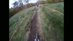
Photos of Keeseville Mountain Bike

Recent Trail Reports
| status | trail | date | condition | info | user |
|---|---|---|---|---|---|
| Slayer | Aug 8, 2025 @ 10:06am Aug 8, 2025 | Ideal | Amos50sL2M | ||
| The Trooper | May 14, 2025 @ 5:15pm May 14, 2025 | Ideal | nicolaim | ||
| Anthrax | May 14, 2025 @ 5:15pm May 14, 2025 | Ideal | nicolaim | ||
| Megadeth - ...the Punishment Due | Oct 4, 2024 @ 5:20pm Oct 4, 2024 | Ideal | cirkle ChasmRiders | ||
| Overkill - Drunken Wisdom | Oct 4, 2024 @ 5:20pm Oct 4, 2024 | Ideal | cirkle ChasmRiders | ||
| Exodus - Deathamphetamine | Oct 4, 2024 @ 5:20pm Oct 4, 2024 | Ideal | cirkle ChasmRiders | ||
| Megadeth - Peace Sells | Oct 4, 2024 @ 5:20pm Oct 4, 2024 | Ideal | cirkle ChasmRiders | ||
| Megadeth - Skin o' My Teeth | Oct 4, 2024 @ 5:20pm Oct 4, 2024 | Ideal | cirkle ChasmRiders | ||
| Megadeth - Dawn Patrol/ Escape | Oct 4, 2024 @ 5:20pm Oct 4, 2024 | Ideal | cirkle ChasmRiders | ||
| Megadeth - Wake Up Dead | Oct 4, 2024 @ 5:20pm Oct 4, 2024 | Ideal | cirkle ChasmRiders |
Activity Feed
| username | action | type | title | date |
|---|---|---|---|---|
| mountainmomma76 | wishlist | region | activity #96193166 | Jun 3, 2026 @ 5:25pm 13 hours |
| Ccoffenberg | wishlist | region | activity #96008528 | Jun 1, 2026 @ 4:29am Jun 1, 2026 |
| Joeyelton | ridden | trail | activity #95953579 | May 31, 2026 @ 10:08am May 31, 2026 |
| LiamShredz | wishlist | region | activity #93641390 | Apr 29, 2026 @ 5:41am Apr 29, 2026 |
| EvilKnevil67 | wishlist | region | activity #89102726 | Feb 17, 2026 @ 5:22pm Feb 17, 2026 |
Recent Comments
| username | type | title | comment | date |
|---|---|---|---|---|
| report | I’m | Oct 2, 2025 @ 10:02am Oct 2, 2025 | ||
| report | Great condition | Aug 12, 2024 @ 3:08pm Aug 12, 2024 | ||
| trail | Cleared leaves and fallen trees. Trail is... | Sep 3, 2020 @ 7:23pm Sep 3, 2020 |
Local Badges
-

10 Black Trails25 awarded -

Epic Ride Climb 2k5 awarded -

Climbing 10k Badge9 awarded -

Climbing 100k Badge0 awarded -

Epic Ride Descent 2k5 awarded -

Descent 10k Badge10 awarded
Activity Type Stats
| activitytype | trails | distance | descent | descent distance | total vertical | rating | global rank | state rank | photos | reports | routes | ridelogs |
|---|---|---|---|---|---|---|---|---|---|---|---|---|
| Mountain Bike | 135 | 20 miles | 1,552 ft | 8 miles | 144 ft | #1,644 | #612 | 153 | 804 | 11 | 4,140 | |
| E-Bike | 3 | 338 ft | 7 ft | 203 ft | 10 ft | #10,616 | #3,417 | 745 | 46 | |||
| Hike | 154 | 34 miles | 3,537 ft | 12 miles | 2,119 ft | #3,947 | #1,397 | 1 | 800 | 306 | ||
| Trail Running | 153 | 34 miles | 3,537 ft | 12 miles | 2,119 ft | #3,729 | #1,112 | 800 | 32 | |||
| Snowmobile | 6 | 43 miles | 3,586 ft | 18 miles | 1,152 ft | #240 | #114 | |||||
| Snowshoe | 3 | 2 miles | 125 ft | 3,271 ft | 98 ft | 13 | ||||||
| Backcountry Ski | 2 | 2 miles | 125 ft | 3,271 ft | 98 ft | 3 | ||||||
| Nordic Ski | 3 | 2 miles | 125 ft | 3,271 ft | 98 ft | 16 |
Frequently Asked Questions About Keeseville
▼
What are the best places to ride in Keeseville?
Keeseville has 3 areas to explore for mountain biking. The top rated areas are:
▼
What are the highest rated mountain biking trails in Keeseville?
The highest rated mountain biking trails in Keeseville are:
- Anthrax - Antisocial (4.2/5)
- Anthrax - Gung Ho (4.2/5)
- Overkill - No Remorse (4.1/5)
- Overkill (4.1/5)
- Exciter (4/5)
▼
What is the best time of the year to ride in Keeseville?
Based on ride log data, the most popular months to ride in Keeseville are:
- July (144 activities)
- August (86 activities)
- June (68 activities)
▼
Where can I park to ride in Keeseville?
There are 6 parking locations listed in Keeseville. The most popular parking spots are: View all parking and trailhead locations on the map to plan your visit.
Activities
Trails
Points of Interest
- Poke-O-Moonshine Fire Tower Sight
- Pokamoonshine Mountain Summit
- Horseshoe Falls Overlook Viewpoint
- Hemlock Heights Overlook Viewpoint
- Sentry Box Overlook Viewpoint
- Whirlpool Basin Overlook Viewpoint
- Carl Mountain Summit
- Notch Mountain Summit
- Old Rang Mountain Summit
- McGuire Mountain Summit
- Mount Fay (2,300 ft)
- Old Rang Mountain (2,277 ft)
- Carl Mountain (2,238 ft)
- By brenthillier
 NSMBA TRAILFORKS & contributors
 - Admins: ChasmRiders
- #15609 - 2,950 views
- keeseville activity log | embed map of Keeseville mountain bike trails | keeseville mountain biking points of interest
Downloading of trail gps tracks in kml & gpx formats is enabled for Keeseville.
You must login to download files.