close
-
Layers w
- Weather Layers
- Pro
- Pro
- Pro
- Pro
- Pro
- Pro
- More Layers
- Pro
- Pro
- Pro
- Pro
-
Upgrade to

3D
Trail Conditions
- Unknown
- Snow Groomed
- Snow Packed
- Snow Covered
- Snow Cover Partial
- Freeze/thaw Cycle
- Icy
- Prevalent Mud
- Wet
- Variable
- Ideal
- Dry
- Very Dry
Trail Flow (Ridden Direction)
Trailforks scans users ridelogs to determine the most popular direction each trail is ridden. A good flowing trail network will have most trails flowing in a single direction according to their intension.
The colour categories are based on what percentage of riders are riding a trail in its intended direction.
The colour categories are based on what percentage of riders are riding a trail in its intended direction.
- > 96%
- > 90%
- > 80%
- > 70%
- > 50%
- < 50%
- bi-directional trail
- no data
Trail Last Ridden
Trailforks scans ridelogs to determine the last time a trail was ridden.
- < 2 days
- < 1 week
- < 2 weeks
- < 1 month
- < 6 months
- > 6 months
Trail Ridden Direction
The intended direction a trail should be ridden.
- Downhill Only
- Downhill Primary
- Both Directions
- Uphill Primary
- Uphill Only
- One Direction
Contribute Details
Colors indicate trail is missing specified detail.
- Description
- Photos
- Description & Photos
- Videos
Trail Popularity ?
Trailforks scans ridelogs to determine which trails are ridden the most in the last 9 months.
Trails are compared with nearby trails in the same city region with a possible 25 colour shades.
Think of this as a heatmap, more rides = more kinetic energy = warmer colors.
- most popular
- popular
- less popular
- not popular
ATV/ORV/OHV Filter
Max Vehicle Width
inches
US Cell Coverage
Legend

Radar Time
Activity Recordings
Trailforks uses anonymized public activity data.
?
Activity Recordings
Trailforks uses anonymized public activity data.
?
Personal Heatmap
▶
Activity Types
all
/
none
▶
Options
2
Date range
month
–
Winter Trails
Warning
A routing network for winter maps does not exist. Selecting trails using the winter trails layer has been disabled.
Missing Trails
Most Popular
Least Popular
Trails are colored based on popularity. The more popular a trail is, the more red. Less popular trails trend towards green.
Jump Magnitude Heatmap
Heatmap of where riders jump on trails. Zoom in to see individual jumps, click circles to view jump details.
BC Backroad Status
![map legend]()
Service Road Atlas is a free to use, community-driven service for viewing and creating reports on the numerous back-country service roads around B.C. and Alberta.

Slope Aspect
Direction the slope faces
Trails Deemphasized
Trails are shown in grey.
Only show trails with no bike usage.
Suggested Layers
Based on selected activity type
Save the current map location and zoom level as your default home location whenever this page is loaded.
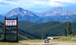
SaveKeystone area trails not including the Keystone Bike Park
Activities Click to view
- Mountain Bike
49 trails
- E-Bike
40 trails
- Gravel Bike
0 trails
- Adaptive Bike
0 trails
- Winter Fat Bike
0 trails
- Horse
4 trails
- Hike
21 trails
- Trail Running
16 trails
- Dirtbike/Moto
3 trails
- Snowshoe
3 trails
- Downhill Ski
148 trails
- Backcountry Ski
0 trails
- Nordic Ski
4 trails
Region Details
- 8
- 16
- 8
- 9
- 7
Region Status
Caution as of May 23, 2026Stats
- Avg Trail Rating
- Trails (view details)
- 194
- Trails Mountain Bike
- 49
- Trails E-Bike
- 40
- Trails Horse
- 4
- Trails Hike
- 21
- Trails Trail Running
- 16
- Trails Dirtbike/Moto
- 3
- Trails Observed Trials
- 1
- Trails ATV/ORV/OHV
- 3
- Trails Snowshoe
- 3
- Trails Downhill Ski
- 150
- Trails Nordic Ski
- 4
- Total Distance
- 126 miles
- Total Descent
- 81,096 ft
- Total Vertical
- 3,233 ft
- Highest Trailhead
- 12,291 ft
- Reports
- 1,530
- Photos
- 316
- Ridden Counter
- 33,653
Articles
Race Report: Catanzarite & Kelley win Revolution Enduro Round 4 at Keystone
Aug 7, 2025 from pinkbike.com
Two days of excellent racing on the notoriously rough, rugged and long trails at the Keystone bike park.
Sub Regions
-
Keystone Resort
- 11
- 5
- 9
- 7
Popular Keystone Mountain Biking Trails
• 100 ★ 4.4 • 3 miles • 905 ft • 913 •
Popular blue difficulty singletrack. This multi-use trail can be used both directions and has a moderate overall physical rating with a 905 ft blue climb. It features bridge. Trail visibility is always easy to follow. On average it takes 42 minutes to complete this trail.
• 100 ★ 3.5 • 1 mile • 50 ft • 625 •
Popular green difficulty singletrack. This multi-use trail can be used both directions. On average it takes 9 minutes to complete this trail.
• 90 ★ 3.4 • 4,738 ft • 34 ft • 257 •
Starts off with a bit off a steep descent off of the Aqueduct Trail, but once you cross Keystone Gulch it is a really flat and easy spin connecting to the resort access roads
• 75 ★ 3.8 • 1 mile • 0 ft • 212 •
Steep and can be difficult to climb up at the beginning and end to the connection
• 80 ★ 4.0 • 3,406 ft • 0 ft • 154 •
Fast and flowy start with some features in the trees. Only two stumps on the whole trail! Opens up down lower with some fun rocks.
• 65 ★ 3.0 • 1,207 ft • 7 ft • 125 •
Moderately popular green difficulty singletrack. This mountain bike primary trail can be used both directions and has a moderate overall physical rating with a 7 ft green climb. On average it takes 4 minutes to complete this trail.
• 60 ★ 3.0 • 3,166 ft • 0 ft • 111 •
Fast and flowy into rocky tech down lower has been removed in 2024. Replaced with machine graded flat and loose trail with poor corner support for bikers. All technical trail has been removed.
• 75 ★ 2.0 • 1,437 ft • 29 ft • 106 •
Scenic shortcut through big pines along the Snake River between the Mountain House and River Run base area.
Keystone Mountain Bike Routes
★ 5.0 • 22 miles • 3,181 ft • 16 • Loop •
This loop route is a great mid alpine tour! The majority of the climbing (1800') comes in the first 6...
5 miles • 508 ft • 2 •
41 miles • 5,890 ft • 11 • Loop •
1 mile • 1 • Point to Point •
★ 1.5 • 13 miles • 2,254 ft • 2 • Out & Back •
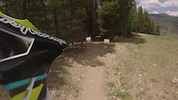
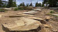
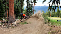
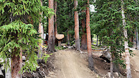
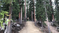
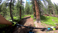
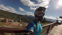
Photos of Keystone Mountain Bike
Videos of Keystone Mountain Bike
trail: Paid-in-Full
0:17 |
136 |
Jul 25, 2022
trail: High Speed Dirt
0:12 |
235 |
Jul 4, 2022

trail: Cowboy Up
0:12 |
136 |
Jul 9, 2020
trail: Cowboy Up
0:36 |
460 |
May 26, 2020
trail: Cowboy Up
0:36 |
|
May 26, 2020
trail: Cowboy Up
0:31 |
108 |
Aug 18, 2019
trail: West Ridge
3:23 |
259 |
Jul 29, 2019
trail: Jam Rock
0:58 |
336 |
Jan 12, 2017
Recent Trail Reports
| status | trail | date | condition | info | user |
|---|---|---|---|---|---|
| Incline | May 23, 2026 @ 5:10pm (America/Denver) May 23, 2026 | Dry | pbosque | ||
| West Ridge | May 18, 2026 @ 10:34am (America/Denver) May 18, 2026 | Dry | Vxindy | ||
| Two Stump | May 3, 2026 @ 11:41am (America/Denver) May 3, 2026 | Dry | ajerred | ||
| Frog (PAH-QWUN) Trail | Apr 4, 2026 @ 2:30pm (America/Denver) Apr 4, 2026 | Ideal | rocky-mtn-wheelworks SCoMBA | ||
| Summit Express Quad | Feb 10, 2026 @ 10:54am (America/Denver) Feb 10, 2026 | Unknown | markholloway Trailforks | ||
| Ina's Way | Feb 10, 2026 @ 10:53am (America/Denver) Feb 10, 2026 | Unknown | markholloway Trailforks | ||
| Granny's | Nov 12, 2025 @ 12:29pm (America/Denver) Nov 12, 2025 | Dry | J4m3z420 SCoMBA | ||
| Gulch Connector | Nov 12, 2025 @ 12:29pm (America/Denver) Nov 12, 2025 | Dry | J4m3z420 SCoMBA | ||
| Wild Thing | Nov 8, 2025 @ 11:41am (America/Denver) Nov 8, 2025 | Snow Covered | J4m3z420 SCoMBA | ||
| Suz’s Cruise | Nov 8, 2025 @ 11:41am (America/Denver) Nov 8, 2025 | Snow Covered | J4m3z420 SCoMBA |
Activity Feed
| username | action | type | title | date |
|---|---|---|---|---|
| Loulouq | wishlist | route | activity #97593333 | Jun 22, 2026 @ 5:09pm 2 days |
| Henryzuehls7 | ridden | trail | activity #97400150 | Jun 20, 2026 @ 8:46am Jun 20, 2026 |
| Stormlab | wishlist | route | activity #97315399 | Jun 19, 2026 @ 7:20am Jun 19, 2026 |
| kukla_707 | wishlist | region | activity #97295885 | Jun 18, 2026 @ 9:20pm Jun 18, 2026 |
| Kcalla56 | add | video | activity #97270651 | Jun 18, 2026 @ 12:43pm Jun 18, 2026 |
Recent Comments
| username | type | title | comment | date |
|---|---|---|---|---|
| trail | Just steep enough to get your heart rate up,... | Jun 4, 2026 @ 3:12pm Jun 4, 2026 | ||
| trail | Aptly named. At times you will share the trail... | May 29, 2026 @ 4:09pm May 29, 2026 | ||
| trail | Clear and dry. | May 23, 2026 @ 3:08pm May 23, 2026 | ||
| trail | It's rideable up, but most people are not... | Apr 3, 2026 @ 8:14pm Apr 3, 2026 | ||
| trail | FDRD may have had some trail days there, but... | Nov 13, 2025 @ 6:54am Nov 13, 2025 |
Local Badges
-

Top 10 Trails1 awarded -

Big Ride 30k1,044 awarded -

Epic Ride 50k328 awarded -

10 Expert Trails21 awarded -

Descent 100k Badge2 awarded -

Completionist0 awarded
Bike & Skill Parks
| name | type | city | rating |
|---|---|---|---|
| Keystone Resort | bike park | Keystone |
Local Mountain Biking Directory
-
Norski SportsBike Shop
Activity Type Stats
| activitytype | trails | distance | descent | descent distance | total vertical | rating | global rank | state rank | photos | reports | routes | ridelogs |
|---|---|---|---|---|---|---|---|---|---|---|---|---|
| Mountain Bike | 49 | 51 miles | 10,390 ft | 21 miles | 2,884 ft | #1,186 | #458 | 301 | 1,513 | 14 | 9,042 | |
| E-Bike | 40 | 37 miles | 9,961 ft | 18 miles | 2,513 ft | #3,024 | #1,117 | 795 | 172 | |||
| Horse | 4 | 6 miles | 154 ft | 5,154 ft | 951 ft | #2,389 | #1,320 | 239 | 1 | 1 | ||
| Hike | 21 | 24 miles | 1,129 ft | 4 miles | 2,884 ft | #6,109 | #2,146 | 1,478 | 3 | 498 | ||
| Trail Running | 16 | 24 miles | 1,129 ft | 4 miles | 2,884 ft | #6,105 | #1,963 | 1,478 | 3 | 134 | ||
| Dirtbike/Moto | 3 | 8 miles | 95 ft | 2,687 ft | #1,025 | #394 | 236 | 13 | ||||
| Observed Trials | 1 | 1 mile | 636 ft | 1 | ||||||||
| ATV/ORV/OHV | 3 | 8 miles | 95 ft | 2,687 ft | 185 | |||||||
| Snowshoe | 3 | 3 miles | 640 ft | 2 miles | 538 ft | #973 | #476 | 220 | 2 | 9 | ||
| Downhill Ski | 148 | 68 miles | 69,925 ft | 65 miles | 2,949 ft | #111 | #48 | 858 | 5,603 | |||
| Nordic Ski | 4 | 5 miles | 433 ft | 2 miles | 213 ft | #897 | #364 | 213 | 277 |
Frequently Asked Questions About Keystone
▼
What are the best places to ride in Keystone?
Keystone has 3 areas to explore for mountain biking. The top rated areas are:
▼
What are the highest rated mountain biking trails in Keystone?
The highest rated mountain biking trails in Keystone are:
- Jam Rock (4.6/5)
- Paid-in-Full (4.5/5)
- Eye of the Tiger (4.4/5)
- Cowboy Up (4.3/5)
- High Speed Dirt (4.3/5)
▼
What is the best time of the year to ride in Keystone?
Based on ride log data, the most popular months to ride in Keystone are:
- July (67 activities)
- August (53 activities)
- June (34 activities)
▼
Where can I park to ride in Keystone?
There are 15 parking locations listed in Keystone. The most popular parking spots are: View all parking and trailhead locations on the map to plan your visit.
Activities
Trails
- By J4m3z420
 SCoMBA & contributors
 - Admins: SCoMBA
- #4172 - 10,319 views
- keystone activity log | embed map of Keystone mountain bike trails | keystone mountain biking points of interest
Downloading of trail gps tracks in kml & gpx formats is enabled for Keystone.
You must login to download files.