close
-
Layers w
- Weather Layers
- Pro
- Pro
- Pro
- Pro
- Pro
- Pro
- More Layers
- Pro
- Pro
- Pro
- Pro
-
Upgrade to

3D
Trail Conditions
- Unknown
- Snow Groomed
- Snow Packed
- Snow Covered
- Snow Cover Partial
- Freeze/thaw Cycle
- Icy
- Prevalent Mud
- Wet
- Variable
- Ideal
- Dry
- Very Dry
Trail Flow (Ridden Direction)
Trailforks scans users ridelogs to determine the most popular direction each trail is ridden. A good flowing trail network will have most trails flowing in a single direction according to their intension.
The colour categories are based on what percentage of riders are riding a trail in its intended direction.
The colour categories are based on what percentage of riders are riding a trail in its intended direction.
- > 96%
- > 90%
- > 80%
- > 70%
- > 50%
- < 50%
- bi-directional trail
- no data
Trail Last Ridden
Trailforks scans ridelogs to determine the last time a trail was ridden.
- < 2 days
- < 1 week
- < 2 weeks
- < 1 month
- < 6 months
- > 6 months
Trail Ridden Direction
The intended direction a trail should be ridden.
- Downhill Only
- Downhill Primary
- Both Directions
- Uphill Primary
- Uphill Only
- One Direction
Contribute Details
Colors indicate trail is missing specified detail.
- Description
- Photos
- Description & Photos
- Videos
Trail Popularity ?
Trailforks scans ridelogs to determine which trails are ridden the most in the last 9 months.
Trails are compared with nearby trails in the same city region with a possible 25 colour shades.
Think of this as a heatmap, more rides = more kinetic energy = warmer colors.
- most popular
- popular
- less popular
- not popular
ATV/ORV/OHV Filter
Max Vehicle Width
inches
US Cell Coverage
Legend

Radar Time
Activity Recordings
Trailforks uses anonymized public activity data.
?
Activity Recordings
Trailforks uses anonymized public activity data.
?
Personal Heatmap
▶
Activity Types
all
/
none
▶
Options
2
Date range
month
–
Winter Trails
Warning
A routing network for winter maps does not exist. Selecting trails using the winter trails layer has been disabled.
Missing Trails
Most Popular
Least Popular
Trails are colored based on popularity. The more popular a trail is, the more red. Less popular trails trend towards green.
Jump Magnitude Heatmap
Heatmap of where riders jump on trails. Zoom in to see individual jumps, click circles to view jump details.
BC Backroad Status
![map legend]()
Service Road Atlas is a free to use, community-driven service for viewing and creating reports on the numerous back-country service roads around B.C. and Alberta.

Slope Aspect
Direction the slope faces
Trails Deemphasized
Trails are shown in grey.
Only show trails with no bike usage.
Suggested Layers
Based on selected activity type
Save the current map location and zoom level as your default home location whenever this page is loaded.
Save
No description for Kukës has been added yet!
Login or register to submit one.
Activities Click to view
- Mountain Bike
10 trails
- E-Bike
10 trails
- Adaptive Bike
- Horse
9 trails
- Hike
10 trails
- Trail Running
10 trails
- ATV/ORV/OHV
6 trails
Region Details
- 2
- 6
Region Status
Open as of Apr 8, 2025Stats
- Avg Trail Rating
- Trails (view details)
- 9
- Trails Mountain Bike
- 10
- Trails E-Bike
- 10
- Trails Horse
- 9
- Trails Hike
- 10
- Trails Trail Running
- 10
- Trails Dirtbike/Moto
- 1
- Trails ATV/ORV/OHV
- 6
- Trails Snowmobile
- 3
- Trails Snowshoe
- 1
- Total Distance
- 66 miles
- Total Descent
- 21,020 ft
- Total Vertical
- 5,091 ft
- Highest Trailhead
- 6,879 ft
- Reports
- 15
- Photos
- 62
- Ridden Counter
- 6
Popular Kukës Mountain Biking Trails
• 5 ★ 5.0 • 16 miles • 3,873 ft • 2 •
Less popular blue difficulty alpine singletrack. This multi-use trail can be used both directions and has a moderate overall physical rating with a 3,873 ft blue climb. It features a-frame, berm, rock garden and other. Trail visibility is sometimes hard to follow.
• 5 ★ 5.0 • 6 miles • 595 ft • 2 •
Less popular blue difficulty alpine singletrack. This mountain bike primary trail can be used downhill primary and has a moderate overall physical rating with a 595 ft blue climb. It features a-frame, berm, rock garden and other. Trail visibility is sometimes hard to follow.
• 5 ★ 3.0 • 2 miles • 2,203 ft • 2 •
Less popular blue difficulty alpine singletrack. This multi-use trail can be used both directions and has a moderate overall physical rating with a 2,203 ft blue climb. It features berm, rock face and rock garden. Winter use: Classic snow grooming. Trail visibility is sometimes hard to follow. A license is required to use this trail.
• 5 ★ 4.0 • 6 miles • 219 ft • 1 • • hike
Less popular blue difficulty alpine singletrack. This hike primary trail can be used downhill only and has a moderate overall physical rating with a 219 ft blue climb. It features berm, rock face and rock garden. Trail visibility is sometimes hard to follow.
• 5 ★ 0.0 • 1 mile • 0 ft •
Rruja mount that has a very wild vista when you see it from far away.One of the many trails that were situated above the two tunnels was even the “chestnut trail” a wild trail which was used by the habitants of the 3 small...
• 5 ★ 0.0 • 3 miles • 305 ft •
Less popular blue difficulty dirt/gravel road. This multi-use trail can be used both directions and has a moderate overall physical rating with a 305 ft blue climb. It features berm. Trail visibility is always easy to follow.
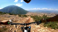
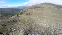
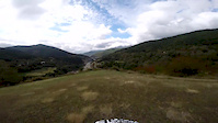
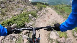
Photos of Kukës Mountain Bike
Videos of Kukës Mountain Bike
trail: Qafa e Zbinecit Trail
0:53 |
23 |
Jul 22, 2020
trail: Qafa e Kumbullës
0:43 |
2 |
Oct 16, 2019
trail: Thirrë Trail
0:57 |
7 |
Oct 11, 2019
trail: Shishtavec-Fshat Trail
3:49 |
273 |
Jul 4, 2021 , Kukës
Recent Trail Reports
no previous reports, add one now!
Activity Feed
| username | action | type | title | date |
|---|---|---|---|---|
| SCHROM | wishlist | trail | activity #68772325 and 1 more | Mar 31, 2025 @ 2:33pm Mar 31, 2025 |
| andiqyqja | update | trail | activity #51661624 | Apr 25, 2024 @ 2:08am Apr 25, 2024 |
| Benediktujrc4 | wishlist | trail | activity #44818218 and 1 more | Oct 3, 2023 @ 3:06am Oct 3, 2023 |
| derbikedude | wishlist | trail | activity #44314342 | Sep 20, 2023 @ 1:21am Sep 20, 2023 |
| Driesvho | wishlist | trail | activity #44260347 | Sep 18, 2023 @ 1:09pm Sep 18, 2023 |
Activity Type Stats
| activitytype | trails | distance | descent | descent distance | total vertical | rating | global rank | state rank | photos | reports | routes | ridelogs |
|---|---|---|---|---|---|---|---|---|---|---|---|---|
| Mountain Bike | 10 | 66 miles | 21,020 ft | 35 miles | 5,092 ft | #1,638 | #3 | 62 | 15 | 15 | ||
| E-Bike | 10 | 66 miles | 21,020 ft | 35 miles | 5,092 ft | #914 | #7 | 15 | ||||
| Horse | 9 | 60 miles | 16,686 ft | 30 miles | 4,967 ft | #199 | #6 | 2 | ||||
| Hike | 10 | 66 miles | 21,020 ft | 35 miles | 5,092 ft | #1,449 | #10 | 15 | 11 | |||
| Trail Running | 10 | 66 miles | 21,020 ft | 35 miles | 5,092 ft | #1,074 | #7 | 15 | ||||
| Dirtbike/Moto | 1 | 3 miles | 341 ft | 1 mile | 157 ft | |||||||
| ATV/ORV/OHV | 6 | 42 miles | 9,567 ft | 19 miles | 4,967 ft | #122 | #6 | |||||
| Snowmobile | 3 | 34 miles | 9,177 ft | 17 miles | 4,498 ft | |||||||
| Snowshoe | 1 | 2 miles | 3 ft | 240 ft | 2,198 ft |
Frequently Asked Questions About Kukës
▼
What are the highest rated mountain biking trails in Kukës?
The highest rated mountain biking trails in Kukës are:
- Gryka e Cajës Trail (4.1/5)
- Shishtavec-Fshat Trail (4.1/5)
- Bicaj - Kroi Kuq Trail (4/5)
- Qafa e Zbinecit Trail (3.8/5)
- Thirrë Trail (0/5)
▼
What is the best time of the year to ride in Kukës?
Based on ride log data, the most popular months to ride in Kukës are:
- August (1 activities)
▼
Where can I park to ride in Kukës?
Check the Kukës trail map for trailhead and parking information. Community members regularly update access and parking details for trails in the area.
▼
What is the longest trail in Kukës?
The longest trail in Kukës is Shishtavec-Fshat Trail at 25.9 km. View all trails sorted by distance.
Activities
Trails
Points of Interest
- By andiqyqja
 TRAILFORKS & contributors
 - Admins: andiqyqja
- #30183 - 1,281 views
- kukës activity log | embed map of Kukës mountain bike trails |
Downloading of trail gps tracks in kml & gpx formats is enabled for Kukës.
You must login to download files.