close
-
Layers w
- Weather Layers
- Pro
- Pro
- Pro
- Pro
- Pro
- Pro
- More Layers
- Pro
- Pro
- Pro
- Pro
-
Upgrade to

3D
Trail Conditions
- Unknown
- Snow Groomed
- Snow Packed
- Snow Covered
- Snow Cover Partial
- Freeze/thaw Cycle
- Icy
- Prevalent Mud
- Wet
- Variable
- Ideal
- Dry
- Very Dry
Trail Flow (Ridden Direction)
Trailforks scans users ridelogs to determine the most popular direction each trail is ridden. A good flowing trail network will have most trails flowing in a single direction according to their intension.
The colour categories are based on what percentage of riders are riding a trail in its intended direction.
The colour categories are based on what percentage of riders are riding a trail in its intended direction.
- > 96%
- > 90%
- > 80%
- > 70%
- > 50%
- < 50%
- bi-directional trail
- no data
Trail Last Ridden
Trailforks scans ridelogs to determine the last time a trail was ridden.
- < 2 days
- < 1 week
- < 2 weeks
- < 1 month
- < 6 months
- > 6 months
Trail Ridden Direction
The intended direction a trail should be ridden.
- Downhill Only
- Downhill Primary
- Both Directions
- Uphill Primary
- Uphill Only
- One Direction
Contribute Details
Colors indicate trail is missing specified detail.
- Description
- Photos
- Description & Photos
- Videos
Trail Popularity ?
Trailforks scans ridelogs to determine which trails are ridden the most in the last 9 months.
Trails are compared with nearby trails in the same city region with a possible 25 colour shades.
Think of this as a heatmap, more rides = more kinetic energy = warmer colors.
- most popular
- popular
- less popular
- not popular
ATV/ORV/OHV Filter
Max Vehicle Width
inches
US Cell Coverage
Legend

Radar Time
Activity Recordings
Trailforks uses anonymized public activity data.
?
Activity Recordings
Trailforks uses anonymized public activity data.
?
Personal Heatmap
▶
Activity Types
all
/
none
▶
Options
2
Date range
month
–
Winter Trails
Warning
A routing network for winter maps does not exist. Selecting trails using the winter trails layer has been disabled.
Missing Trails
Most Popular
Least Popular
Trails are colored based on popularity. The more popular a trail is, the more red. Less popular trails trend towards green.
Jump Magnitude Heatmap
Heatmap of where riders jump on trails. Zoom in to see individual jumps, click circles to view jump details.
BC Backroad Status
![map legend]()
Service Road Atlas is a free to use, community-driven service for viewing and creating reports on the numerous back-country service roads around B.C. and Alberta.

Slope Aspect
Direction the slope faces
Trails Deemphasized
Trails are shown in grey.
Only show trails with no bike usage.
Suggested Layers
Based on selected activity type
Save the current map location and zoom level as your default home location whenever this page is loaded.
Save
No description for Lévis has been added yet!
Login or register to submit one.
Activities Click to view
- Mountain Bike
72 trails
- E-Bike
72 trails
- Gravel Bike
0 trails
- Adaptive Bike
0 trails
- Winter Fat Bike
0 trails
- Hike
17 trails
- Trail Running
26 trails
- Snowshoe
12 trails
- Nordic Ski
31 trails
Region Details
- 6
- 1
- 26
- 24
- 11
- 3
Region Status
Caution as of May 16, 2026Stats
- Avg Trail Rating
- Trails (view details)
- 105
- Trails Mountain Bike
- 72
- Trails E-Bike
- 72
- Trails Hike
- 17
- Trails Trail Running
- 26
- Trails Dirtbike/Moto
- 1
- Trails Snowshoe
- 12
- Trails Nordic Ski
- 31
- Total Distance
- 85 miles
- Total Descent
- 4,259 ft
- Total Vertical
- 273 ft
- Highest Trailhead
- 361 ft
- Reports
- 548
- Photos
- 713
- Ridden Counter
- 11,648
Sub Regions
-
Centre Plein-Air Lévis
- 2
- 1
-
Les Sentiers La Balade
- 10
- 12
- 4
- 2
-
Parc Les Écarts Valéro
- 7
- 3
- 2
-
Pintendre
- 9
- 6
- 4
Popular Lévis Mountain Biking Trails
• 100 ★ 4.9 • 1,785 ft • 0 ft • 382 •
Sentier plus difficile, offrant des défis techniques intéressants. Plusieurs ponts, "Berns" et sauts
• 90 ★ 2.9 • 3,261 ft • 8 ft • 352 •
Niveau débutant 1,5 Km, assez linéaire, plusieurs virages et ... quelque petits ponceaux !
• 80 ★ 3.7 • 1,601 ft • 21 ft • 343 •
Popular green difficulty singletrack. This mountain bike primary trail can be used downhill primary. On average it takes 3 minutes to complete this trail.
• 100 ★ 4.1 • 2,408 ft • 0 ft • 339 •
Sentier intermédiaire offrant plusieurs défis. Partie longeant la rivière à la scie superbe !
• 100 ★ 4.5 • 925 ft • 0 ft • 331 •
Sentier intermédiaire qui longe la rivière à la scie, section technique de 400 m. Au-dela des attentes! Plusieurs ponts et ponceaux
• 100 ★ 4.0 • 1,453 ft • 3 ft • 318 •
Petit détour pour améliorer la sécurité et éviter de rouler dans le chemin. Belle section a l'abris de la poussière du chemin. Agréable de passer dans la plantation d'épinettes.
• 95 ★ 4.5 • 3,848 ft • 0 ft • 309 •
« Sentier de calibre débutant commençant après la traversée d’un superbe pont en bois. Montée en lacets le long d’une belle petite rivière suivi d’une arrivée sur un plateau dans un parcours boisé étroit...Tout à fait...
Lévis Mountain Bike Routes
★ 2.0 • 7 miles • 524 ft • 12 • Out & Back •
Petit loop SLB qui passe par la pluspart des piste coté saint jean
• 5 miles • 211 ft • 8 •
• 5 miles • 38 ft • 10 •
• 5 miles • 47 ft • 14 •
• 6 miles • 496 ft • 12 •
• 9 miles • 73 ft • 19 •
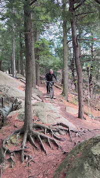
Photos of Lévis Mountain Bike
Videos of Lévis Mountain Bike
trail: Panorama slabing
0:35 |
48 |
Oct 18, 2025
trail: La Clin D'Oeil
0:09 |
|
May 23, 2020

0:51 |
28 |
Dec 13, 2025

trail: La Clin D'Oeil
31:44 |
281 |
Feb 10, 2023 , Lévis

trail: La Crête en Tête
31:44 |
84 |
Feb 10, 2023 , Lévis

trail: La Passe à Jack
31:44 |
82 |
Feb 10, 2023 , Lévis
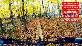
trail: Les Ti-Ponceaux
31:44 |
108 |
Feb 10, 2023 , Lévis

trail: La Ouate... Chez-vous!
31:44 |
147 |
Feb 10, 2023 , Lévis
Recent Trail Reports
| status | trail | date | condition | info | user |
|---|---|---|---|---|---|
| Alcatraz w | May 16, 2026 @ 10:54am (America/Toronto) May 16, 2026 | Unknown | altair1 | ||
| Manon des sources | May 13, 2026 @ 4:12pm (America/Toronto) May 13, 2026 | Variable | 2nepy9 | ||
| Le Grand Écart | May 13, 2026 @ 4:11pm (America/Toronto) May 13, 2026 | Variable | 2nepy9 | ||
| Chic la Yanik | May 13, 2026 @ 4:10pm (America/Toronto) May 13, 2026 | Variable | 2nepy9 | ||
| P’tit Écart | May 13, 2026 @ 4:09pm (America/Toronto) May 13, 2026 | Variable | 2nepy9 | ||
| Pierres tombales | Apr 27, 2026 @ 1:48pm (America/Moncton) Apr 27, 2026 | Ideal | a-algora | ||
| L'aventurière | Apr 27, 2026 @ 1:48pm (America/Moncton) Apr 27, 2026 | Ideal | a-algora | ||
| Guébin | Apr 27, 2026 @ 1:48pm (America/Moncton) Apr 27, 2026 | Ideal | a-algora | ||
| Électrisante Alt | Apr 27, 2026 @ 1:48pm (America/Moncton) Apr 27, 2026 | Ideal | a-algora | ||
| Électrisante | Apr 27, 2026 @ 1:48pm (America/Moncton) Apr 27, 2026 | Ideal | a-algora |
Activity Feed
| username | action | type | title | date |
|---|---|---|---|---|
| RaphalXesoqs | ridden | trail | activity #97069318 | Jun 15, 2026 @ 3:32pm 2 days |
| DoomTheFlame | add | photo | activity #97034196 and 7 more | Jun 15, 2026 @ 5:22am 2 days |
| DoomTheFlame | update | trail | activity #97033936 | Jun 15, 2026 @ 5:15am 2 days |
| DoomTheFlame | ridden | trail | activity #96198382 | Jun 3, 2026 @ 6:40pm Jun 3, 2026 |
| DoomTheFlame | vote | trail | activity #96198373 | Jun 3, 2026 @ 6:40pm Jun 3, 2026 |
Recent Comments
| username | type | title | comment | date |
|---|---|---|---|---|
| report | Quelque spot mou mais faut la rouler pour la... | Oct 20, 2025 @ 11:22am Oct 20, 2025 | ||
| report | Piste en construction Glaise profonde ne pas... | Jun 17, 2022 @ 11:52am Jun 17, 2022 | ||
| trail | Très belle piste, de très beau berm mais un... | Oct 5, 2020 @ 4:22pm Oct 5, 2020 | ||
| trail | Superbe place à aller découvrir | Aug 3, 2020 @ 9:40am Aug 3, 2020 | ||
| trail | Sentier plus difficile, avec de bons défis.... | Jun 27, 2020 @ 4:21am Jun 27, 2020 |
Local Badges
-

Epic Ride Climb 2k2 awarded -

Climbing 10k Badge20 awarded -

Climbing 100k Badge0 awarded -

Epic Ride Descent 2k2 awarded -

Descent 10k Badge19 awarded -

Descent 100k Badge1 awarded
Bike & Skill Parks
| name | type | city | rating |
|---|---|---|---|
| Pump Track Umano | skill park | Lévis | |
| Parc d'habilleté | skill park | Lévis |
Activity Type Stats
| activitytype | trails | distance | descent | descent distance | total vertical | rating | global rank | state rank | photos | reports | routes | ridelogs |
|---|---|---|---|---|---|---|---|---|---|---|---|---|
| Mountain Bike | 72 | 40 miles | 2,411 ft | 11 miles | 220 ft | #1,452 | #19 | 712 | 540 | 1 | 11,996 | |
| E-Bike | 72 | 51 miles | 2,982 ft | 15 miles | 210 ft | #2,436 | #18 | 501 | 1 | 316 | ||
| Hike | 17 | 13 miles | 814 ft | 4 miles | 220 ft | #6,456 | #58 | 483 | 302 | |||
| Trail Running | 26 | 17 miles | 1,152 ft | 5 miles | 220 ft | #5,294 | #43 | 1 | 487 | 437 | ||
| Dirtbike/Moto | 1 | 1,447 ft | 62 ft | 1,119 ft | 66 ft | 50 | 2 | |||||
| Snowshoe | 12 | 8 miles | 650 ft | 2 miles | 148 ft | #739 | #23 | 28 | 120 | |||
| Nordic Ski | 31 | 42 miles | 1,293 ft | 11 miles | 262 ft | #331 | #12 | 10 | 1 | 1,337 |
Frequently Asked Questions About Lévis
▼
What are the best places to ride in Lévis?
Lévis has 7 areas to explore for mountain biking. The top rated areas are:
▼
What are the highest rated mountain biking trails in Lévis?
The highest rated mountain biking trails in Lévis are:
- La Clin D'Oeil (4.6/5)
- La Crête en Tête (4.3/5)
- La Crête en tête ( Parti difficile ) (4.3/5)
- La Ouate... Chez-vous! (4.3/5)
- Fourmi Atomique (4.2/5)
▼
What is the best time of the year to ride in Lévis?
Based on ride log data, the most popular months to ride in Lévis are:
- July (314 activities)
- August (256 activities)
- June (227 activities)
▼
Where can I park to ride in Lévis?
There are 8 parking locations listed in Lévis. The most popular parking spots are: View all parking and trailhead locations on the map to plan your visit.
Activities
Trails
- By StephaneMarceau
 TRAILFORKS & contributors
 - Admins: VQ, bigjay, StephaneMarceau, Canadmos
- #8930 - 16,278 views
- lévis activity log | embed map of Lévis mountain bike trails | lévis mountain biking points of interest polygons
Downloading of trail gps tracks in kml & gpx formats is enabled for Lévis.
You must login to download files.