close
-
Layers w
- Weather Layers
- Pro
- Pro
- Pro
- Pro
- Pro
- Pro
- More Layers
- Pro
- Pro
- Pro
- Pro
-
Upgrade to

3D
Trail Conditions
- Unknown
- Snow Groomed
- Snow Packed
- Snow Covered
- Snow Cover Partial
- Freeze/thaw Cycle
- Icy
- Prevalent Mud
- Wet
- Variable
- Ideal
- Dry
- Very Dry
Trail Flow (Ridden Direction)
Trailforks scans users ridelogs to determine the most popular direction each trail is ridden. A good flowing trail network will have most trails flowing in a single direction according to their intension.
The colour categories are based on what percentage of riders are riding a trail in its intended direction.
The colour categories are based on what percentage of riders are riding a trail in its intended direction.
- > 96%
- > 90%
- > 80%
- > 70%
- > 50%
- < 50%
- bi-directional trail
- no data
Trail Last Ridden
Trailforks scans ridelogs to determine the last time a trail was ridden.
- < 2 days
- < 1 week
- < 2 weeks
- < 1 month
- < 6 months
- > 6 months
Trail Ridden Direction
The intended direction a trail should be ridden.
- Downhill Only
- Downhill Primary
- Both Directions
- Uphill Primary
- Uphill Only
- One Direction
Contribute Details
Colors indicate trail is missing specified detail.
- Description
- Photos
- Description & Photos
- Videos
Trail Popularity ?
Trailforks scans ridelogs to determine which trails are ridden the most in the last 9 months.
Trails are compared with nearby trails in the same city region with a possible 25 colour shades.
Think of this as a heatmap, more rides = more kinetic energy = warmer colors.
- most popular
- popular
- less popular
- not popular
ATV/ORV/OHV Filter
Max Vehicle Width
inches
US Cell Coverage
Legend

Radar Time
Activity Recordings
Trailforks uses anonymized public activity data.
?
Activity Recordings
Trailforks uses anonymized public activity data.
?
Personal Heatmap
▶
Activity Types
all
/
none
▶
Options
2
Date range
month
–
Winter Trails
Warning
A routing network for winter maps does not exist. Selecting trails using the winter trails layer has been disabled.
Missing Trails
Most Popular
Least Popular
Trails are colored based on popularity. The more popular a trail is, the more red. Less popular trails trend towards green.
Jump Magnitude Heatmap
Heatmap of where riders jump on trails. Zoom in to see individual jumps, click circles to view jump details.
BC Backroad Status
![map legend]()
Service Road Atlas is a free to use, community-driven service for viewing and creating reports on the numerous back-country service roads around B.C. and Alberta.

Slope Aspect
Direction the slope faces
Trails Deemphasized
Trails are shown in grey.
Only show trails with no bike usage.
Suggested Layers
Based on selected activity type
Save the current map location and zoom level as your default home location whenever this page is loaded.
Save
No description for Lienz has been added yet!
Login or register to submit one.
Links
This region uses the Uk/Euro style trail grading system.
Activities Click to view
- Mountain Bike
6 trails
- E-Bike
6 trails
- Adaptive Bike
0 trails
- Winter Fat Bike
0 trails
- Hike
2 trails
- Trail Running
2 trails
Region Details
- 1
- 2
- 2
- 1
Region Status
Open as of Oct 1, 2025Stats
- Avg Trail Rating
- Trails (view details)
- 6
- Trails Mountain Bike
- 6
- Trails E-Bike
- 6
- Trails Hike
- 2
- Trails Trail Running
- 2
- Total Distance
- 14 miles
- Total Descent Distance
- 8 miles
- Total Descent
- 5,078 ft
- Total Vertical
- 5,089 ft
- Highest Trailhead
- 7,314 ft
- Reports
- 42
- Photos
- 35
- Ridden Counter
- 1,054
Sub Regions
-
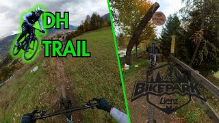
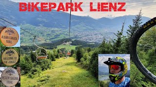
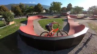
Bikepark Lienz
- 1
- 2
- 1
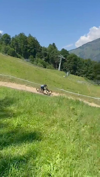
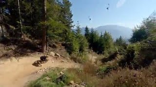
Popular Lienz Mountain Biking Trails
• 50 ★ 3.8 • 3 miles • 51 ft • 185 •
Flowy trail with a mellow decline that's suitable for beginners but offers lots of fun (in terms of airtime) for experienced riders.
• 70 ★ 4.6 • 3 miles • 156 ft • 162 •
The starts at the Moosalm at approx. 1000 m above sea level. From there the newly created trail of 4 kilometres length winds through the shady forest towards Bruck Castle and on to the valley station. About 340 metres of difference in...
• 85 ★ 3.6 • 1 mile • 17 ft • 158 •
https://www.osttirol.com/osttirol-erleben/sommerurlaub-osttirol/radsport/bikepark-lienz.html
• 35 ★ 3.2 • 2,083 ft • 6 ft • 147 •
Palmen, Sandstrand und Cocktails wirst du auf der neuen “Welcome to the Jungle Line“ vergeblich suchen, dafür aber einen schwarzen Trail, der es in sich hat. Knackige 600 Meter ist die neue Variante lang und zieht sich entlang der...
• 100 ★ 4.0 • 3 miles • 358 ft • 10 •
Gestartet wird der shared-Trail am Endpunkt der MTB-Route Golzentipp (MTB 157) am Folmasaisattel. Auf dem hügeligen Bergrücken von Bergwiesen oberhalb des Waldes schlängelt sich der naturbelassene shared-Trail mit viel Flow in...
Photos of Lienz Mountain Bike
Videos of Lienz Mountain Bike
trail: Lakata Trail
0:16 |
28 |
Apr 30, 2025
trail: Lakata Trail
6:28 |
230 |
Nov 29, 2023 , Lienz
trail: Flow Family Trail
6:39 |
265 |
Nov 8, 2023 , Lienz

trail: Lakata Trail
12:27 |
336 |
Oct 23, 2021 , Lienz

trail: Welcome to the Jungle
12:27 |
436 |
Oct 23, 2021 , Lienz
trail: Peter Sagan Trail
12:27 |
888 |
Oct 23, 2021 , Lienz
0:21 |
657 |
Oct 4, 2018
trail: Lakata Trail
4:41 |
692 |
Oct 3, 2018 , Lienz
Recent Trail Reports
| status | trail | date | condition | info | user |
|---|---|---|---|---|---|
| Bergwiesentrail | Aug 25, 2025 @ 11:18am Aug 25, 2025 | Dry | SlayerHippie | ||
| Lakata Trail | Aug 14, 2025 @ 8:25am Aug 14, 2025 | Dry | crisotop UpperTrails | ||
| Flow Family Trail | Aug 14, 2025 @ 8:24am Aug 14, 2025 | Dry | crisotop UpperTrails | ||
| Peter Sagan Trail | Aug 14, 2025 @ 8:19am Aug 14, 2025 | Dry | crisotop UpperTrails | ||
| Welcome to the Jungle | Aug 23, 2023 @ 2:32am Aug 23, 2023 | Dry | kevin-vnc | ||
| Connector: Peter-Sagan-Trail –> Lakata-Trail | Jun 7, 2021 @ 12:01am Jun 7, 2021 | Unknown | ktm-boy-69 TRAILFORKS |
Activity Feed
| username | action | type | title | date |
|---|---|---|---|---|
| micmuec | ridden | trail | activity #96318279 and 2 more | Jun 5, 2026 @ 1:31pm 2 days |
| MartasBC | ridden | trail | activity #91277901 and 1 more | Mar 25, 2026 @ 12:13pm Mar 25, 2026 |
| MartasBC | wishlist | trail | activity #91277859 | Mar 25, 2026 @ 12:12pm Mar 25, 2026 |
| bryckels | wishlist | trail | activity #89075382 | Feb 17, 2026 @ 8:21am Feb 17, 2026 |
| Molitracer | wishlist | region | activity #88734640 | Feb 11, 2026 @ 10:42am Feb 11, 2026 |
Recent Comments
| username | type | title | comment | date |
|---|---|---|---|---|
| trail | Hammertrail mit großartigem Panorama.... | Aug 25, 2025 @ 11:26am Aug 25, 2025 | ||
| trail | Sehr ausgefahren und erodiert. Ziemlich... | Aug 14, 2025 @ 8:25am Aug 14, 2025 | ||
| trail | Braucht ein paar Runs bis man die Sprünge... | Aug 14, 2025 @ 8:23am Aug 14, 2025 | ||
| trail | Unklare bis nicht vorhandene Linienführung.... | Aug 14, 2025 @ 8:21am Aug 14, 2025 | ||
| trail | Kann mich nur anschließen, seltsamer... | Aug 14, 2025 @ 8:20am Aug 14, 2025 |
Bike & Skill Parks
| name | type | city | rating |
|---|---|---|---|
| Bikepark Lienz | bike park | Lienz | |
| Pumptrack Bikepark Lienz | skill park | Lienz |
Activity Type Stats
| activitytype | trails | distance | descent | descent distance | total vertical | rating | global rank | state rank | photos | reports | routes | ridelogs |
|---|---|---|---|---|---|---|---|---|---|---|---|---|
| Mountain Bike | 6 | 14 miles | 5,079 ft | 8 miles | 5,089 ft | #3,399 | #32 | 36 | 42 | 1,253 | ||
| E-Bike | 6 | 14 miles | 5,079 ft | 8 miles | 5,089 ft | #2,201 | #29 | 38 | 73 | |||
| Hike | 2 | 7 miles | 817 ft | 2 miles | 5,059 ft | #3,984 | #49 | 29 | 313 | |||
| Trail Running | 2 | 7 miles | 817 ft | 2 miles | 5,059 ft | #3,388 | #40 | 29 | 27 |
Frequently Asked Questions About Lienz
▼
What are the best places to ride in Lienz?
Lienz has 1 areas to explore for mountain biking. The top rated areas are:
▼
What are the highest rated mountain biking trails in Lienz?
The highest rated mountain biking trails in Lienz are:
- Flow Family Trail (4.3/5)
- Peter Sagan Trail (3.9/5)
- Lakata Trail (3.7/5)
- Welcome to the Jungle (3.5/5)
- Bergwiesentrail (0/5)
▼
What is the best time of the year to ride in Lienz?
Based on ride log data, the most popular months to ride in Lienz are:
- July (11 activities)
- October (6 activities)
- June (6 activities)
▼
Where can I park to ride in Lienz?
There are 2 parking locations listed in Lienz. The most popular parking spots are:
Trails
- By lines
 TRAILFORKS & contributors
 - Admins: PatrickMeraner
- #25557 - 4,444 views
- lienz activity log | embed map of Lienz mountain bike trails | lienz mountain biking points of interest
Downloading of trail gps tracks in kml & gpx formats is enabled for Lienz.
You must login to download files.