close
-
Layers w
- Weather Layers
- Pro
- Pro
- Pro
- Pro
- Pro
- Pro
- More Layers
- Pro
- Pro
- Pro
- Pro
-
Upgrade to

3D
Trail Conditions
- Unknown
- Snow Groomed
- Snow Packed
- Snow Covered
- Snow Cover Partial
- Freeze/thaw Cycle
- Icy
- Prevalent Mud
- Wet
- Variable
- Ideal
- Dry
- Very Dry
Trail Flow (Ridden Direction)
Trailforks scans users ridelogs to determine the most popular direction each trail is ridden. A good flowing trail network will have most trails flowing in a single direction according to their intension.
The colour categories are based on what percentage of riders are riding a trail in its intended direction.
The colour categories are based on what percentage of riders are riding a trail in its intended direction.
- > 96%
- > 90%
- > 80%
- > 70%
- > 50%
- < 50%
- bi-directional trail
- no data
Trail Last Ridden
Trailforks scans ridelogs to determine the last time a trail was ridden.
- < 2 days
- < 1 week
- < 2 weeks
- < 1 month
- < 6 months
- > 6 months
Trail Ridden Direction
The intended direction a trail should be ridden.
- Downhill Only
- Downhill Primary
- Both Directions
- Uphill Primary
- Uphill Only
- One Direction
Contribute Details
Colors indicate trail is missing specified detail.
- Description
- Photos
- Description & Photos
- Videos
Trail Popularity ?
Trailforks scans ridelogs to determine which trails are ridden the most in the last 9 months.
Trails are compared with nearby trails in the same city region with a possible 25 colour shades.
Think of this as a heatmap, more rides = more kinetic energy = warmer colors.
- most popular
- popular
- less popular
- not popular
ATV/ORV/OHV Filter
Max Vehicle Width
inches
US Cell Coverage
Legend

Radar Time
Activity Recordings
Trailforks uses anonymized public activity data.
?
Activity Recordings
Trailforks uses anonymized public activity data.
?
Personal Heatmap
▶
Activity Types
all
/
none
▶
Options
2
Date range
month
–
Winter Trails
Warning
A routing network for winter maps does not exist. Selecting trails using the winter trails layer has been disabled.
Missing Trails
Most Popular
Least Popular
Trails are colored based on popularity. The more popular a trail is, the more red. Less popular trails trend towards green.
Jump Magnitude Heatmap
Heatmap of where riders jump on trails. Zoom in to see individual jumps, click circles to view jump details.
BC Backroad Status
![map legend]()
Service Road Atlas is a free to use, community-driven service for viewing and creating reports on the numerous back-country service roads around B.C. and Alberta.

Slope Aspect
Direction the slope faces
Trails Deemphasized
Trails are shown in grey.
Only show trails with no bike usage.
Suggested Layers
Based on selected activity type
Save the current map location and zoom level as your default home location whenever this page is loaded.
Save
No description for Madera has been added yet!
Login or register to submit one.
Activities Click to view
- Mountain Bike
8 trails
- Hike
8 trails
- Trail Running
8 trails
Region Details
- 2
- 5
Region Status
Open as of Nov 30, 2025Stats
- Avg Trail Rating
- Trails (view details)
- 7
- Trails Mountain Bike
- 8
- Trails E-Bike
- 2
- Trails Gravel Bike
- 2
- Trails Adaptive Bike
- 1
- Trails Horse
- 3
- Trails Hike
- 8
- Trails Trail Running
- 8
- Total Distance
- 6 miles
- Total Descent
- 758 ft
- Total Vertical
- 212 ft
- Highest Trailhead
- 741 ft
- Reports
- 25
- Photos
- 55
- Ridden Counter
- 481
Sub Regions
-
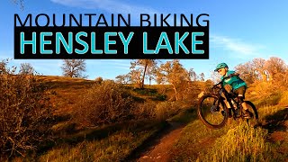
Hensley Lake Recreation Area
- 5
Popular Madera Mountain Biking Trails
• 100 ★ 0.0 • 1 mile • 48 ft • 132 •
Popular green difficulty singletrack. This multi-use trail can be used downhill primary. On average it takes 16 minutes to complete this trail.
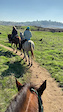
• 90 ★ 0.0 • 2 miles • 289 ft • 100 • • horse
Popular green difficulty singletrack. This horse primary trail can be used downhill primary. On average it takes 31 minutes to complete this trail.
• 75 ★ 3.0 • 1,175 ft • 2 ft • 77 •
Popular green difficulty singletrack. This mountain bike primary trail can be used downhill primary. On average it takes minutes to complete this trail.
• 60 ★ 0.0 • 3,682 ft • 143 ft • 63 •
Moderately popular green difficulty singletrack. This mountain bike primary trail can be used downhill primary. On average it takes 8 minutes to complete this trail.
• 5 ★ 3.4 • 1 mile • 251 ft • 59 •
This is a great place to learn because of its figure 8 configuration. It is rolling hills with some nice singletrack and a couple of very short technical sections for you to learn some skills. You are never more than a couple miles from...
Madera Mountain Bike Routes
★ 5.0 • 2,493 ft • 104 ft • 4 • Loop •
Technical part of the trail, jumps, and berms, big rocks and steep downhills next to few cliffs. The trail...
Photos of Madera Mountain Bike
Videos of Madera Mountain Bike

trail: Buck Ridge Loop
18:46 |
298 |
Mar 6, 2023 , Madera

trail: Buck Ridge Loop
18:46 |
251 |
Mar 6, 2023 , Madera
trail: Buck Ridge Loop
18:46 |
150 |
Mar 6, 2023 , Madera

trail: Buck Ridge Loop
18:46 |
162 |
Mar 6, 2023 , Madera
trail: Buck Ridge Loop
0:17 |
8 |
Dec 23, 2023
Recent Trail Reports
| status | trail | date | condition | info | user |
|---|---|---|---|---|---|
| Buck Ridge Loop | Nov 30, 2025 @ 11:59am (America/Los_Angeles) Nov 30, 2025 | Ideal | Darrelp | ||
| Buck Ridge Loop | Nov 30, 2025 @ 11:59am (America/Los_Angeles) Nov 30, 2025 | Ideal | Darrelp | ||
| Buck Ridge Loop | May 4, 2024 @ 1:56pm May 4, 2024 | Ideal | Lucas6dhfy | ||
| Buck Ridge Loop | Dec 31, 2021 @ 10:49am Dec 31, 2021 | Ideal | Darrelp | ||
| Buck Ridge Loop | May 16, 2021 @ 9:55am May 16, 2021 | Dry | TT400ex |
Activity Feed
| username | action | type | title | date |
|---|---|---|---|---|
| dirtydynamo | add | trail | activity #94635335 and 1 more | May 13, 2026 @ 10:13am May 13, 2026 |
| NumquamEodem | wishlist | trail | activity #87194354 and 3 more | Jan 14, 2026 @ 12:11pm Jan 14, 2026 |
| Darrelp | add | report | activity #85069203 and 1 more | Dec 2, 2025 @ 12:34pm Dec 2, 2025 |
| BikeRegCom | add | event | activity #83959875 | Nov 11, 2025 @ 6:36am Nov 11, 2025 |
| janet7575 | ridden | trail | activity #83452660 | Nov 2, 2025 @ 9:10am Nov 2, 2025 |
Recent Comments
| username | type | title | comment | date |
|---|---|---|---|---|
| trail | This trail is definitely not a green, but... | Sep 30, 2021 @ 8:51pm Sep 30, 2021 | ||
| trail | Trailforks says I gave this ride 1 star on... | Jul 15, 2020 @ 8:17pm Jul 15, 2020 |
Activity Type Stats
| activitytype | trails | distance | descent | descent distance | total vertical | rating | global rank | state rank | photos | reports | routes | ridelogs |
|---|---|---|---|---|---|---|---|---|---|---|---|---|
| Mountain Bike | 8 | 6 miles | 758 ft | 2 miles | 213 ft | #8,365 | #2,701 | 53 | 25 | 1,132 | ||
| E-Bike | 2 | 21 | 104 | |||||||||
| Gravel Bike | 2 | #7,163 | #2,240 | 9 | ||||||||
| Adaptive Bike | 1 | #7,172 | #2,239 | |||||||||
| Horse | 3 | 3 miles | 197 ft | 4,865 ft | 200 ft | 4 | 10 | |||||
| Hike | 8 | 6 miles | 758 ft | 2 miles | 213 ft | #12,984 | #4,684 | 26 | 1 | 51 | ||
| Trail Running | 8 | 6 miles | 758 ft | 2 miles | 213 ft | #12,493 | #4,376 | 26 | 1 | 22 |
Frequently Asked Questions About Madera
▼
What are the best places to ride in Madera?
Madera has 1 areas to explore for mountain biking. The top rated areas are:
▼
What are the highest rated mountain biking trails in Madera?
The highest rated mountain biking trails in Madera are:
- Buck Ridge Loop (3.8/5)
- Buck Ridge Loop (3.8/5)
- Buck Ridge Loop (0/5)
- Buck Ridge Loop (0/5)
- Buck Ridge Loop (0/5)
▼
What is the best time of the year to ride in Madera?
Based on ride log data, the most popular months to ride in Madera are:
- December (12 activities)
- November (11 activities)
- October (9 activities)
▼
Where can I park to ride in Madera?
There are 1 parking locations listed in Madera. The most popular parking spots are:
Trails
Points of Interest
- By aoneal & contributors
- Admins: TheAngryTomato
- #13635 - 2,504 views
- madera activity log | embed map of Madera mountain bike trails | madera mountain biking points of interest
Downloading of trail gps tracks in kml & gpx formats is enabled for Madera.
You must login to download files.