close
-
Layers w
- Weather Layers
- Pro
- Pro
- Pro
- Pro
- Pro
- Pro
- More Layers
- Pro
- Pro
- Pro
- Pro
-
Upgrade to

3D
Trail Conditions
- Unknown
- Snow Groomed
- Snow Packed
- Snow Covered
- Snow Cover Partial
- Freeze/thaw Cycle
- Icy
- Prevalent Mud
- Wet
- Variable
- Ideal
- Dry
- Very Dry
Trail Flow (Ridden Direction)
Trailforks scans users ridelogs to determine the most popular direction each trail is ridden. A good flowing trail network will have most trails flowing in a single direction according to their intension.
The colour categories are based on what percentage of riders are riding a trail in its intended direction.
The colour categories are based on what percentage of riders are riding a trail in its intended direction.
- > 96%
- > 90%
- > 80%
- > 70%
- > 50%
- < 50%
- bi-directional trail
- no data
Trail Last Ridden
Trailforks scans ridelogs to determine the last time a trail was ridden.
- < 2 days
- < 1 week
- < 2 weeks
- < 1 month
- < 6 months
- > 6 months
Trail Ridden Direction
The intended direction a trail should be ridden.
- Downhill Only
- Downhill Primary
- Both Directions
- Uphill Primary
- Uphill Only
- One Direction
Contribute Details
Colors indicate trail is missing specified detail.
- Description
- Photos
- Description & Photos
- Videos
Trail Popularity ?
Trailforks scans ridelogs to determine which trails are ridden the most in the last 9 months.
Trails are compared with nearby trails in the same city region with a possible 25 colour shades.
Think of this as a heatmap, more rides = more kinetic energy = warmer colors.
- most popular
- popular
- less popular
- not popular
ATV/ORV/OHV Filter
Max Vehicle Width
inches
US Cell Coverage
Legend

Radar Time
Activity Recordings
Trailforks uses anonymized public activity data.
?
Activity Recordings
Trailforks uses anonymized public activity data.
?
Personal Heatmap
▶
Activity Types
all
/
none
▶
Options
2
Date range
month
–
Winter Trails
Warning
A routing network for winter maps does not exist. Selecting trails using the winter trails layer has been disabled.
Missing Trails
Most Popular
Least Popular
Trails are colored based on popularity. The more popular a trail is, the more red. Less popular trails trend towards green.
Jump Magnitude Heatmap
Heatmap of where riders jump on trails. Zoom in to see individual jumps, click circles to view jump details.
BC Backroad Status
![map legend]()
Service Road Atlas is a free to use, community-driven service for viewing and creating reports on the numerous back-country service roads around B.C. and Alberta.

Slope Aspect
Direction the slope faces
Trails Deemphasized
Trails are shown in grey.
Only show trails with no bike usage.
Suggested Layers
Based on selected activity type
Save the current map location and zoom level as your default home location whenever this page is loaded.
SaveDwellingup Adventure Trails - Dwellingup Mountain Bike Trails
Covering Dwellingup town, Marrinup circuit, and Turner Hill trails, as well as a section of the Munda Biddi trail.
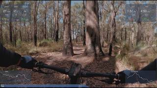
Set among the towering jarrah forests north-east of Dwellingup town, the Dwellingup Mountain Bike Trails network delivers one of the region’s most distinctive mountain bike experiences: a purpose-built system where flowing descents, hand-built cross-country character and a deep forest atmosphere combine to create riding that feels both accessible and rewarding. As one of the cornerstone riding areas within the broader Dwellingup Adventure Trails network, Marrinup offers trails suited to progressing riders while still providing enough technical depth, terrain variation and trail personality to keep experienced mountain bikers engaged.
Unlike gravity-focused destinations built around shuttle access, these trails reward riders who enjoy earning their descents. Trails weave through native forest on a combination of ridgelines, gullies and granite-studded slopes, producing a riding experience defined by short climbs, flowing berms, natural rock features and traditional cross-country terrain. The network blends modern machine-built flow with older-style technical singletrack, creating a varied experience where riders can link short descents, scenic traverses and longer loops into rides of different lengths and difficulty.
At the heart of the network sits the Marrinup Circuit, one of Western Australia’s original cross-country mountain bike trails. The 7.7 km loop remains a defining feature of the riding area, offering mild terrain and a hand-built, technical character that provides something for nearly every rider. Rather than relying on sustained elevation, the circuit uses the natural contours of the landscape to deliver a rewarding rhythm of climbing, descending and technical interest through the forest.
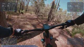
From the circuit, riders can branch into an increasingly diverse collection of purpose-built trails. Cuckoo introduces a classic Marrinup ride profile, beginning with an approximately 800-metre cross-country climb over rocks and roots before opening into an extended descent through the forest. Cloak and Dagger balances effort and reward with a steady climb followed by a flowing, gradual descent, making it a popular linking trail for longer loops. BFG and Blaze deliver progressively more spirited descending, featuring berms, rock rollovers, tabletops and optional technical features that appeal to riders seeking more speed and progression.
Closer to the lower slopes and trailhead zones, shorter trails such as Bullish, Electric Blue, Whistler, Ripper and Skipper provide compact but rewarding riding. Bullish is designed as an easy all-mountain descent with flowing berms, while Electric Blue packs tight turns, tabletop features and rock rollovers into a short descending trail. Whistler adds a more traditional cross-country feel with optional technical lines for confident riders, while Ripper serves as a gentler climbing return trail to reconnect riders with the Marrinup Circuit. Skipper, despite its short length, offers a quick climb that helps riders link surrounding descents into repeatable loops.
For riders seeking a more relaxed experience or a gentler introduction to the terrain, Emu Run and Shingleback provide approachable cross-country riding that can be linked with the Munda Biddi Trail to create enjoyable loops from town or the Marrinup Camping Area. The Munda Biddi itself passes through the network as a dual-direction touring trail, adding broader regional connectivity and requiring riders to remain alert for oncoming cyclists. The shared-use World Away trail also links key points of interest, connecting the Marrinup Camping Area with the Marrinup POW Camp Walk and the Cloak and Dagger mountain bike trail, creating opportunities to combine riding with short heritage or walking experiences.
Land Managers and Trail Stewardship
The network is located on public forest lands managed by the Department of Biodiversity, Conservation and Attractions (DBCA) through the Parks and Wildlife Service, which oversees the surrounding state forest estate and recreational infrastructure. The trails form part of the broader Dwellingup Adventure Trails network, a regional initiative promoting nature-based recreation across Dwellingup and surrounding areas. Visitor services and local trail information are supported through the Dwellingup Trails and Visitor Centre, while regional tourism promotion occurs under the Dwellingup Adventure Trails identity. The network passes through lands of deep cultural significance to the Binjareb/Pinjarup and Wilman people of the Noongar Nation, whose enduring connection to country is acknowledged throughout the Dwellingup trail system.
Covering Dwellingup town, Marrinup circuit, and Turner Hill trails, as well as a section of the Munda Biddi trail.
Set among the towering jarrah forests north-east of Dwellingup town, the Dwellingup Mountain Bike Trails network delivers one of the region’s most distinctive mountain bike experiences: a purpose-built system where flowing descents, hand-built cross-country character and a deep forest atmosphere combine to create riding that feels both accessible and rewarding. As one of the cornerstone riding areas within the broader Dwellingup Adventure Trails network, Marrinup offers trails suited to progressing riders while still providing enough technical depth, terrain variation and trail personality to keep experienced mountain bikers engaged.
Unlike gravity-focused destinations built around shuttle access, these trails reward riders who enjoy earning their descents. Trails weave through native forest on a combination of ridgelines, gullies and granite-studded slopes, producing a riding experience defined by short climbs, flowing berms, natural rock features and traditional cross-country terrain. The network blends modern machine-built flow with older-style technical singletrack, creating a varied experience where riders can link short descents, scenic traverses and longer loops into rides of different lengths and difficulty.
At the heart of the network sits the Marrinup Circuit, one of Western Australia’s original cross-country mountain bike trails. The 7.7 km loop remains a defining feature of the riding area, offering mild terrain and a hand-built, technical character that provides something for nearly every rider. Rather than relying on sustained elevation, the circuit uses the natural contours of the landscape to deliver a rewarding rhythm of climbing, descending and technical interest through the forest.
From the circuit, riders can branch into an increasingly diverse collection of purpose-built trails. Cuckoo introduces a classic Marrinup ride profile, beginning with an approximately 800-metre cross-country climb over rocks and roots before opening into an extended descent through the forest. Cloak and Dagger balances effort and reward with a steady climb followed by a flowing, gradual descent, making it a popular linking trail for longer loops. BFG and Blaze deliver progressively more spirited descending, featuring berms, rock rollovers, tabletops and optional technical features that appeal to riders seeking more speed and progression.
Closer to the lower slopes and trailhead zones, shorter trails such as Bullish, Electric Blue, Whistler, Ripper and Skipper provide compact but rewarding riding. Bullish is designed as an easy all-mountain descent with flowing berms, while Electric Blue packs tight turns, tabletop features and rock rollovers into a short descending trail. Whistler adds a more traditional cross-country feel with optional technical lines for confident riders, while Ripper serves as a gentler climbing return trail to reconnect riders with the Marrinup Circuit. Skipper, despite its short length, offers a quick climb that helps riders link surrounding descents into repeatable loops.
For riders seeking a more relaxed experience or a gentler introduction to the terrain, Emu Run and Shingleback provide approachable cross-country riding that can be linked with the Munda Biddi Trail to create enjoyable loops from town or the Marrinup Camping Area. The Munda Biddi itself passes through the network as a dual-direction touring trail, adding broader regional connectivity and requiring riders to remain alert for oncoming cyclists. The shared-use World Away trail also links key points of interest, connecting the Marrinup Camping Area with the Marrinup POW Camp Walk and the Cloak and Dagger mountain bike trail, creating opportunities to combine riding with short heritage or walking experiences.
Land Managers and Trail Stewardship
The network is located on public forest lands managed by the Department of Biodiversity, Conservation and Attractions (DBCA) through the Parks and Wildlife Service, which oversees the surrounding state forest estate and recreational infrastructure. The trails form part of the broader Dwellingup Adventure Trails network, a regional initiative promoting nature-based recreation across Dwellingup and surrounding areas. Visitor services and local trail information are supported through the Dwellingup Trails and Visitor Centre, while regional tourism promotion occurs under the Dwellingup Adventure Trails identity. The network passes through lands of deep cultural significance to the Binjareb/Pinjarup and Wilman people of the Noongar Nation, whose enduring connection to country is acknowledged throughout the Dwellingup trail system.
Primary Trail Type: Cross-Country
AKA: Marrinup
Land Status: State Forest
 google parking directions
 Access Info:
Trailheads and Access
The trails can be accessed through several entry points, giving riders flexibility in how they experience the network. The principal access point is the Marrinup Trailhead, located adjacent to the Marrinup Camping Area south of Dwellingup, where riders can directly access the Marrinup Circuit and surrounding trail clusters. Parking is available, and the nearby campground provides amenities including camping areas, toilets and facilities for longer stays. Additional access is possible via the Dwellingup South Trailhead, allowing riders to link from town into the southern sections of the network, while some loops can also be approached using Munda Biddi connections. The Dwellingup Trails and Visitor Centre in town serves as the central visitor information point for the broader Dwellingup Adventure Trails system and provides maps, local advice and orientation before riding.
The trails can be accessed through several entry points, giving riders flexibility in how they experience the network. The principal access point is the Marrinup Trailhead, located adjacent to the Marrinup Camping Area south of Dwellingup, where riders can directly access the Marrinup Circuit and surrounding trail clusters. Parking is available, and the nearby campground provides amenities including camping areas, toilets and facilities for longer stays. Additional access is possible via the Dwellingup South Trailhead, allowing riders to link from town into the southern sections of the network, while some loops can also be approached using Munda Biddi connections. The Dwellingup Trails and Visitor Centre in town serves as the central visitor information point for the broader Dwellingup Adventure Trails system and provides maps, local advice and orientation before riding.
Disclaimer:
Permits, Fees and Rider Requirements
No permit or trail access fee is required to ride the Marrinup Trail Network itself. Public access to the mountain bike trails is free. However, riders planning to stay overnight at the Marrinup Camping Area should note that camping fees apply, with bookings and payment requirements administered through Western Australia’s parks system. Riders are encouraged to check current arrangements and any seasonal access information before travelling, particularly during periods of elevated fire risk or temporary trail closures.
Rules, Trail Etiquette and Safety
Marrinup is designed to be welcoming to a broad range of riders, but responsible trail use remains essential. Riders are encouraged to select trails appropriate to their ability, ride within their limits and remain in control at all times. Many trails within the network are directional, while dual-direction sections such as the Munda Biddi Trail require awareness of approaching riders. On shared trails, courteous passing and clear communication are expected. Riders should remain on designated trails, avoid riding muddy conditions where possible to reduce the spread of dieback disease, and carry out all rubbish. Mobile phone coverage in the forest can be limited, and riders are encouraged to ride with a companion and prepare appropriately for emergencies. In an emergency, Triple Zero (000) should be contacted where coverage exists.
Links
Activities Click to view
- Mountain Bike
48 trails
- E-Bike
48 trails
- Hike
18 trails
- Trail Running
22 trails
Region Details
- 14
- 16
- 18
Region Status
Open as of Jun 16, 2026Stats
- Avg Trail Rating
- Trails (view details)
- 51
- Trails Mountain Bike
- 48
- Trails E-Bike
- 48
- Trails Gravel Bike
- 6
- Trails Adaptive Bike
- 3
- Trails Hike
- 18
- Trails Trail Running
- 22
- Total Distance
- 79 miles
- Total Descent Distance
- 33 miles
- Total Descent
- 7,517 ft
- Total Vertical
- 545 ft
- Highest Trailhead
- 1,121 ft
- Reports
- 234
- Photos
- 22
- Ridden Counter
- 1,327
Popular Dwellingup Mountain Bike Trails Trails
• 100 ★ 4.0 • 2 miles • 56 ft • 361 •
Popular blue difficulty singletrack. This multi-use trail can be used one direction. It features berm, drop, jump and gap jump. On average it takes 9 minutes to complete this trail.
• 100 ★ 4.0 • 2 miles • 206 ft • 343 •
A cross-country rider's dream, this trail has long, fast descents combined with rock gardens, tabletops and rock rollovers. Something for everyone as you make your way to the .
• 100 ★ 4.4 • 4,918 ft • 40 ft • 324 •
A gentle cross-country trail through young jarrah forest. Return on the Munda Biddi for an enjoyable short loop from town.
• 95 ★ 4.5 • 4,134 ft • 133 ft • 247 •
Popular blue difficulty singletrack. This mountain bike primary trail can be used one direction and has a moderate overall physical rating with a 133 ft blue climb. It features berm and jump. Trail visibility is always easy to follow. On average it takes 6 minutes to complete this trail.
• 90 ★ 0.0 • 751 ft • 26 ft • 195 •
Popular green difficulty singletrack. This mountain bike primary trail and has a moderate overall physical rating with a 26 ft green climb. On average it takes 1 minutes to complete this trail.
• 95 ★ 3.0 • 1 mile • 9 ft • 188 •
Part of the new Dwellingup trails Project. Easy Blue with some jumps that are avoidable. Not very hilly, no major climbs.
• 80 ★ 4.6 • 5 miles • 480 ft • 183 •
Proceeding clockwise, this easy to follow loop trail starts at the old Marrinup townsite which was destroyed by bush fire in 1961. It is an eight kilometre single track suitable for both the novice and experienced rider. The trail can...
Mountain Bike Routes
★ 5.0 • 18 miles • 1,134 ft • 2 • Point to Point •
Outdoor Recreation students will be arriving by bus to Marrinup and will be riding the Munda Biddi...
37 miles • 3,688 ft • 0 • Loop •
• 14 miles • 1,162 ft • 3 •
• 14 miles • 1,353 ft • 7 •
• 1 mile • 180 ft • 0 •
• 10 miles • 844 ft • 4 •
Photos of Dwellingup Mountain Bike Trails Mountain Bike


Recent Trail Reports
| status | trail | date | condition | info | user |
|---|---|---|---|---|---|
| Ol Skool Hollywood | Jun 17, 2026 @ 12:13pm (Australia/Perth) Jun 16, 2026 | Unknown | sweatytechie MTBWA | ||
| Mother Hubbard | Jun 17, 2026 @ 12:13pm (Australia/Perth) Jun 16, 2026 | Unknown | sweatytechie MTBWA | ||
| World Away | Jun 12, 2026 @ 7:41pm (Australia/Perth) Jun 12, 2026 | Ideal | WillieJacobsz Trailforks | ||
| Whistler | Jun 12, 2026 @ 7:41pm (Australia/Perth) Jun 12, 2026 | Ideal | WillieJacobsz Trailforks | ||
| Watts Road | Jun 12, 2026 @ 7:41pm (Australia/Perth) Jun 12, 2026 | Ideal | WillieJacobsz Trailforks | ||
| The Mack | Jun 12, 2026 @ 7:41pm (Australia/Perth) Jun 12, 2026 | Ideal | WillieJacobsz Trailforks | ||
| Solitary | Jun 12, 2026 @ 7:41pm (Australia/Perth) Jun 12, 2026 | Ideal | WillieJacobsz Trailforks | ||
| Skipper | Jun 12, 2026 @ 7:41pm (Australia/Perth) Jun 12, 2026 | Ideal | WillieJacobsz Trailforks | ||
| Shingleback | Jun 12, 2026 @ 7:41pm (Australia/Perth) Jun 12, 2026 | Ideal | WillieJacobsz Trailforks | ||
| Scarp Road | Jun 12, 2026 @ 7:41pm (Australia/Perth) Jun 12, 2026 | Ideal | WillieJacobsz Trailforks |
Activity Feed
| username | action | type | title | date |
|---|---|---|---|---|
| sweatytechie | update | trail | activity #98620936 | Jul 6, 2026 @ 11:03pm Jul 6, 2026 |
| Bmend1 | rsvp | event | activity #98562299 | Jul 6, 2026 @ 2:52am Jul 6, 2026 |
| sweatytechie | update | trail | activity #97233206 | Jun 17, 2026 @ 10:33pm Jun 17, 2026 |
| ChrisBan21 | update | trail | activity #97184233 | Jun 17, 2026 @ 8:03am Jun 17, 2026 |
| ChrisBan21 | update | trail | activity #97174490 | Jun 17, 2026 @ 4:51am Jun 17, 2026 |
Recent Comments
| username | type | title | comment | date |
|---|---|---|---|---|
| trail | Fantastic new trail. The climb is pretty solid... | May 20, 2026 @ 10:28pm May 20, 2026 | ||
| trail | Beware of loose gravel in some of the berms. ... | Feb 2, 2024 @ 7:05pm Feb 2, 2024 | ||
| trail | Dry and some loose gravel in parts. Fun run | Feb 2, 2024 @ 7:04pm Feb 2, 2024 | ||
| trail | Dry but fairly clear of loose gravel. Good run | Feb 2, 2024 @ 7:03pm Feb 2, 2024 | ||
| trail | This trail is green according to the... | Dec 30, 2023 @ 10:40pm Dec 30, 2023 |
Nearby Areas
| name | distance | ||||
|---|---|---|---|---|---|
| Turner Hill | 2 | 3 | 1 | 4.7 km | |
| Tom's Crossing MTB | 2 | 1 | 5.5 km | ||
| Murray Valley | 8 | 9 | 2 | 6.9 km | |
| Wetlands Park | 1 | 26.2 km | |||
| Langford Park | 2 | 8 | 27.2 km |
Activity Type Stats
| activitytype | trails | distance | descent | descent distance | total vertical | rating | global rank | state rank | photos | reports | routes | ridelogs |
|---|---|---|---|---|---|---|---|---|---|---|---|---|
| Mountain Bike | 48 | 78 miles | 7,310 ft | 33 miles | 472 ft | #2,170 | #116 | 22 | 233 | 2 | 1,953 | |
| E-Bike | 48 | 78 miles | 7,310 ft | 33 miles | 472 ft | #2,129 | #100 | 221 | 109 | |||
| Gravel Bike | 6 | 11 miles | 673 ft | 5 miles | 367 ft | #3,082 | #216 | 16 | 3 | |||
| Adaptive Bike | 3 | 5 miles | 361 ft | 2 miles | 230 ft | #3,092 | #218 | 6 | ||||
| Hike | 18 | 30 miles | 2,418 ft | 14 miles | 545 ft | #6,951 | #216 | 200 | 14 | |||
| Trail Running | 22 | 36 miles | 2,733 ft | 16 miles | 545 ft | #5,418 | #174 | 212 | 40 |
Frequently Asked Questions About Dwellingup Mountain Bike Trails
▼
What are the highest rated mountain biking trails in Dwellingup Mountain Bike Trails?
The highest rated mountain biking trails in Dwellingup Mountain Bike Trails are:
- Blaze (4.5/5)
- Marrinup Circuit (4.3/5)
- Cloak And Dagger (4.1/5)
- Ripper (4.1/5)
- Emu Run (4.1/5)
▼
What is the best time of the year to ride in Dwellingup Mountain Bike Trails?
Based on ride log data, the most popular months to ride in Dwellingup Mountain Bike Trails are:
- October (34 activities)
- September (27 activities)
- March (24 activities)
▼
Where can I park to ride in Dwellingup Mountain Bike Trails?
▼
What is the longest trail in Dwellingup Mountain Bike Trails?
The longest trail in Dwellingup Mountain Bike Trails is Munda Biddi - Oakley Dam To Nanga (North Section) at 5.2 miles. View all trails sorted by distance.
Activities
Trails
- Hard trails in Dwellingup Mountain Bike Trails
- Easy trails in Dwellingup Mountain Bike Trails
- Favorite trails in Dwellingup Mountain Bike Trails
- Most ridden trails in Dwellingup Mountain Bike Trails
- Singletrack in Dwellingup Mountain Bike Trails
- Viewpoint trails in Dwellingup Mountain Bike Trails
- Trails with technical features in Dwellingup Mountain Bike Trails
- By WillieJacobsz
 Trailforks SBP SWW & contributors
 - Admins: apply
- #9326 - 4,824 views
- dwellingup mountain bike trails activity log | embed map of Dwellingup Mountain Bike Trails mountain bike trails | dwellingup mountain bike trails mountain biking points of interest
Downloading of trail gps tracks in kml & gpx formats is enabled for Dwellingup Mountain Bike Trails.
You must login to download files.